
I have been living in San Diego for about 4 months, so I'm out of touch! Are the trails from Lake Avenue in the Pasadena area closed? Was the fire there? So now mudslides?
Thanks!
Liz
Sam Merrill Trail (Echo Mountain)
-
AlanK

- Posts: 1069
- Joined: Thu Sep 27, 2007 9:28 pm
The trail to Echo Mountain is open. So is Castle Canyon. Nothing is open beyond Inspiration Point. The last time I was up, the Upper Sam Merrill Trail was closed.
-
HikeUp

- Posts: 4070
- Joined: Thu Sep 27, 2007 9:21 pm
Based on my observations of trail signs over the last couple of months, this is what I think the current state is...
Lower Sam Merrill is open from Lake to Echo Mountain.
Middle and Upper Sam Merrill Trails are closed.
East Mt. Lowe Trail is closed.
Castle Canyon is open up to Inspiration Point. From Inspiration Point you can go south to Muir Peak.
Idlehour Trail is closed.
I think the trail from Echo Mountain to Cape of Good Hope (the old rail bed) is closed too but this may not be true.
-
blueshammer
- Posts: 105
- Joined: Wed Nov 25, 2009 1:03 pm
I was there in late January and observed no closure signs on the old rail bed trail between Cape of Good Hope and Echo Mtn. There was a big trail closure sign further up the Mt. Lowe road heading northeast from the cape, however.
The Middle (or is that called Upper?) Sam Merrill trail previously had trail closure signs months earlier (both on Echo Mtn. and near Inspiration Point), but I didn't see them last month. Someone may have taken them down?
Sorry, my observations are a month old and may not be accurate...
The Middle (or is that called Upper?) Sam Merrill trail previously had trail closure signs months earlier (both on Echo Mtn. and near Inspiration Point), but I didn't see them last month. Someone may have taken them down?
Sorry, my observations are a month old and may not be accurate...
-
Ze Hiker

- Posts: 1432
- Joined: Mon Jul 28, 2008 7:14 pm
how do you know idlehour is closed, HikeUp?
-
HikeUp
- Posts: 4070
- Joined: Thu Sep 27, 2007 9:21 pm
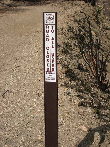
On Feb 13th, I took the following pictures where the Idelhour Trail meets the Mt. Wilson Toll Road...Zé wrote:how do you know idlehour is closed, HikeUp?


If one end is closed, the other is most likely closed too. Also, I think AlanK posted a pic of a 'closed' sign on the road that leads north from Inspiration Point. That along with all the other closures in the area puts the other end of the trail in a closure area.
That being said, signs have been mysteriously disappearing. Not that everyone is paying attention to the signs...
-
AlanK
- Posts: 1069
- Joined: Thu Sep 27, 2007 9:28 pm
I took this picture on January 9. It is of the trail leading north from Inspiration Point.HikeUp wrote:If one end is closed, the other is most likely closed too. Also, I think AlanK posted a pic of a 'closed' sign on the road that leads north from Inspiration Point. That along with all the other closures in the area puts the other end of the trail in a closure area.

-
cougarmagic

- Posts: 1411
- Joined: Wed May 07, 2008 5:21 pm
The back sides of those signs don't say anything....If one end is closed, the other is most likely closed too.
-
HikeUp
- Posts: 4070
- Joined: Thu Sep 27, 2007 9:21 pm
The Forest Service is loving this discussion!
-
Ze Hiker
- Posts: 1432
- Joined: Mon Jul 28, 2008 7:14 pm
I hope they are. In that case...
Hey Forest Service, tell me what's the logic in designating the boundaries of the closure areas along trails, so that we aren't sure if they are actually open or closed? Toll road open, but Idlehour closed?
-
Liz
- Posts: 218
- Joined: Mon Dec 22, 2008 8:59 am
Cool! Thanks for all the replies! I miss the area!
-
PackerGreg

- Posts: 623
- Joined: Sat Sep 12, 2009 9:31 pm
-
simonov

- Posts: 1108
- Joined: Tue Nov 27, 2007 5:44 pm
- Location: Reno, NV
That map suggests the old railway bed is closed.
I am thinking about taking a group up to Echo Mountain, then to Inspiration Point. We could go up Castle Canyon and back, but it would be better if we could loop back via the rail bed.
I am thinking about taking a group up to Echo Mountain, then to Inspiration Point. We could go up Castle Canyon and back, but it would be better if we could loop back via the rail bed.
Nunc est bibendum
-
AlanK
- Posts: 1069
- Joined: Thu Sep 27, 2007 9:28 pm
I believe that you are stuck with Castle Canyon both ways.simonov wrote:That map suggests the old railway bed is closed.
I am thinking about taking a group up to Echo Mountain, then to Inspiration Point. We could go up Castle Canyon and back, but it would be better if we could loop back via the rail bed.
-
SoCal Canyoneer
- Posts: 3
- Joined: Sat May 24, 2008 6:32 pm
The Middle Merrill Trail is officially open so you could make a loop out of it along with Castle Canyon.simonov wrote:I am thinking about taking a group up to Echo Mountain, then to Inspiration Point. We could go up Castle Canyon and back, but it would be better if we could loop back via the rail bed.
-
Taco

- Snownado survivor
- Posts: 6192
- Joined: Thu Sep 27, 2007 4:35 pm
I went into a closed area the other day. Many hillsides caught fire, baby elephants were killed, and special interest groups were oppressed and had their feelings hurt as a result. I also had no idea it was "closed".
-
fortified
- Posts: 105
- Joined: Sat Mar 02, 2013 10:03 pm
On the top of Lake Ave. in Altadena is the old Cobb estate that leads to the Sam Merrill Trail. Their seams to be a growing crowd of kids who have heard about the Cobb estate being haunted. Something about "hearing the footsteps of a dead hiker if you are quiet". Google it. AND THEY ALL HAVE HEADLAMPS BLARING LIGHT DIRECTLY AT EVERYYONES FACE. Their is nothing like going down a trail in the dark and suddenly having five headlamps blaring directly at ones eyes. Nothing shouts newbie like as well. It seems half of the people going up after dark are out there trying to scare each other. OK, fine. I get it. Nothing wrong with a little fun, but please, drop the light. And what is it with these new lights I have seen a couple times recently? The lights could light a mountainside for three miles. And for those wondering, I have gone up that trail a couple hundred times, and never seen a ghost.....And oh...just because I am hiking alone without a flashlight, and coming around the corner of the trail, doesn't mean that I am the ghost!! So if that makes you jump 15 feet in the air and scream, you might want to have one of the others in the lead.
-
VermillionPearlGirl
- Posts: 239
- Joined: Wed Apr 06, 2011 9:57 am
I hike Sam Merrill at night a lot and what bothers me a whole bunch more is all the drinking. Kids and adults go up there to drink, particularly on the weekends. It's like a frat house sometimes, it's amazing.
Haven't run into this though, weird stuff. Usually people eventually figure out not to shine their lamps into people's faces, they just have to have it happen to them a couple times until they get it.
Haven't run into this though, weird stuff. Usually people eventually figure out not to shine their lamps into people's faces, they just have to have it happen to them a couple times until they get it.