
Mt. Baldy via Big Horn Ridge?


Perhaps a good weekend to go to the top and look down the ridge. I think I'll plan to go up the Ski Hut Trail Sunday morning and stroll on over to the top of the Big Horn Ridge.
Edit: Switching to Saturday 10th because I can and because I like the weather outlook better.
Edit: Switching to Saturday 10th because I can and because I like the weather outlook better.
Oh well. Only made it as far up as the ski hut this morning so...no new info. Mid 40's and windy at the hut at 8:00a.I think I'll plan to go up the Ski Hut Trail Sunday morning and stroll on over to the top of the Big Horn Ridge.
Edit: Switching to Saturday 10th because I can and because I like the weather outlook better.
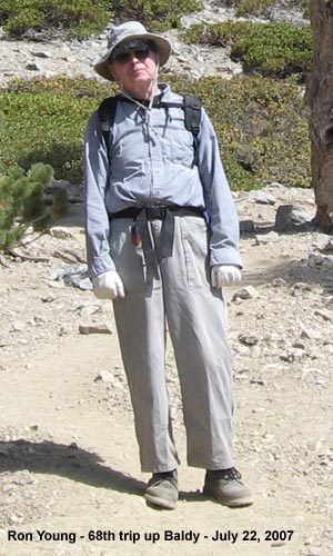
On a side note: As I was sitting at the hut trying to fight off an asthma attack, an older gentleman made his way slowly up to the hut. We said a few words to each other. It wasn't till after he headed on up to Baldy that I figured out who he looked like - John W. Robinson. Is he still an active hiker?
Edit: It wasn't Robinson it reminded me of...it was a guy (Ron Young) whose picture I had seen on Dan Simpson's Hiking site.

Saturday hiked the Bear Flats trail to the summit of Baldy (2h55m) and one of my goals was to scout out a X-Country hike to the summit..
My observations is that this is very doable but quite rugged.
Start at Cow Saddle and follow one of the routes on the Sierra Club Peak baggers to Lookout Peak. About 3/4 of the way up the firebreak to Lookout Peak traverse North to saddle. From here for about 2 miles there is a decent trace trail on the ridge that I had mentioned a few weeks ago on Lookout Peak. Continue on this ridge and it will eventually hit the BearFlats trail at about 8800ft. This ridge drops quite a bit and then gains and then drops and looks quite rugged. It was difficult to see the last 500 ft or so climb until you hit BF trail but if it that was too steep --- traverse East and you will still hit the trail and to the summit.
After I do this ridge the next ridge on the West side of Coldwater Canyon from somewhere near East Fork looks like a completely different and another great adventure!
Playing more and more WEST!
D
dhstein31, on Saturday (11/10/2007) from Ski Hut Trail I had a good view of adventurers like you slugging your way along the wind-exposed "backbone" of Bear Canyon Trail. My heart went out to you. On Ski Hut Trail I didn't feel the northern wind until I reached Baldy Summit.

For the approach from Heaton Flats....
Does anyone have an idea why the old trail did not just use Fossil Canyon ridge to get to Big Horn?
"In the early years of the
present century, a rough trail was built up the long
southwest ridge of Baldy from Weber’s Camp in
Coldwater Canyon. With the demise of Weber’s Camp in
the late 1920s, the trail fell into disuse and disappeared."
Hehehe, Im starting to get interested in this task. A concern from Heaton Flats is all this private property. Is Weber camp off limits?
If not, then I would take a look at leaving Heaton Flats at
http://www.topozone.com/map.asp?lat=34. ... &layer=DRG
I suppose the return route for a recon would be via the regular Heaton Flats trail or legal to return via Coldwater canyon?
Good question about private property. I've heard gun fire down there in Coldwater Canyon (target practice probably) before. Then again maybe that's how they deal with trespassers. Is Cattle Canyon also private property? I noticed some structures, a couple dozers, and what looked like a mining road.
The old trail (I posted something earlier in this thread about it's course via a few UTM points) left Coldwater Canyon approx. where the Heaton Flats Trail enters. I assume the HF trail was the primary route into upper Coldwater, probably well built and heavily travelled due to mining activity. I speculate that the BHR trail took off from that point simply because that's the most logical place to take off from if you're entering Coldwater via the Heaton Flats trail. I believe Weber's Camp came along later and probably just used the existing BHR trail.
I never did take a look at Robinson's The San Gabriels re this subject. Maybe I'll get a chance tonight and see if it mentions anything.
I'm not sure if there's anything much left at Weber's Camp anymore. Maybe a few relics. As I recall, and my memory is a little challenged here, all of the structures were in and around what's marked on the topo map as Widman Ranch. I seem to recall that the area around Weber's didn't have any structures.
I don't think you're supposed to cut through Widman Ranch, but if you dropped off the HF trail prior to Heaton Saddle, and went straight down the ridge to Weber's and cut directly across the canyon to the N ridge of Fossil Canyon, I think you'd avoid the private property. There's a trail marked that goes down the ridge from the HF trail to Weber's, but I'm more than a little skeptical as to its continued existance.
1) From an historic perspective it would be really cool to recreate the old trail from near Widman Ranch up to point 4652'. Epic bushwhacking would greatly diminish the cool factor though! Perhaps leave it as a long range goal.
2) Starting near Weber camp and going up the ridge on the north side of Fossil Canyon is about 2800' of vertical bushwhackery to point 6388' on BHR.
3) Starting on the east side in Cattle Canyon at ~4000' and going up to point 5700' on BHR is a mere 1700' of vertical bush wrangling. This is the route shown on Travis' map.
In my mind, option 3 is the obvious choice for a first attempt/scouting trip. Seems like the best chance to get onto BHR. Once there it's grunt work all the way to the top.
- relatively easy access to Cattle Canyon from Cow Canyon Saddle. Only potential problem I see is that Coldwater Truck Trail is labeled "No Public Access" on my Harrison Map (any one know about this?). Access through Mt. Baldy Ranch is no problem, and I don't know of any private property in Cattle Canyon.
- most likely is the least amount of bushwhacking
- easiest car shuttle in case Baldy is obtained
- easiest retreat route if the ridge cannot be obtained
- if BHR cannot be obtained, we get to explore Cattle Canyon as far up as we can go, including the mining road shown in Rick's photo. Who knows, maybe we can even draw fire!
Just my opinion. As of 11/12, I'm available the next 2 weekends and could join in on the festivities.
Found this on the socal mtb site regarding the truck trail from cow canyon saddle to cattle canyon....add of course that the hike would have to start from Mt.Baldy Ranch.
"
Epic_Mtn_Biker
STR Veteran
Last time i rode that fireroad it as about 10 years ago before there a "no trespassing" sign at the top. down at the bottom there was or is supposed to be a tungsten mine. not sure of the status of it now, but it was 7 miles from the top down to the wash. "
"Pain Freak
Directionally Challenged
I've rode it twice and it is a private road and there is a fellow who told me he'd have me arrested if I came back. It is a hard ride with a lot of ruts and even more deep sand. We rode last time from Cow Saddle down to East fork, then to Azusa Canyon "
"dirttorpeedo
drive monkey, drive!
dean we did cow canyon in sept. like mr freak said tungsten mine and old dood w/ a gun.
"
"
Epic_Mtn_Biker
STR Veteran
Last time i rode that fireroad it as about 10 years ago before there a "no trespassing" sign at the top. down at the bottom there was or is supposed to be a tungsten mine. not sure of the status of it now, but it was 7 miles from the top down to the wash. "
"Pain Freak
Directionally Challenged
I've rode it twice and it is a private road and there is a fellow who told me he'd have me arrested if I came back. It is a hard ride with a lot of ruts and even more deep sand. We rode last time from Cow Saddle down to East fork, then to Azusa Canyon "
"dirttorpeedo
drive monkey, drive!
dean we did cow canyon in sept. like mr freak said tungsten mine and old dood w/ a gun.
"
What time were you on the trail? We might have crossed paths as I was heading down from the ski hut between 8:15a and 9:15a, wearing an orange jacket and black cap. It was fairly breezy at the hut around 8:00a.Rob wrote:dhstein31, on Saturday (11/10/2007) from Ski Hut Trail I had a good view of adventurers like you slugging your way along the wind-exposed "backbone" of Bear Canyon Trail. My heart went out to you. On Ski Hut Trail I didn't feel the northern wind until I reached Baldy Summit.
HikeUp wrote:
When I reached Ski Hut I socialized with others on the lee (sunny south) side of Ski Hut, and the subject of conversation was the lost hiker on SJ. At Ski Hut there was one ill-looking hiker sitting with his head down shivering under a poncho; I spoke to him, and he replied that he was going to be OK.
Ski Hut Trail was fairly busy on Saturday morning. Good thing I skipped my morning coffee (testing coffee vs. altitude effects). At Baldy Summit the population was ~12 with hikers arriving and departing steadily and abbreviating their stay at Summit IVO wind chill. I descended via Devil's Backbone and after those first few hundreds of exposed yards off the summit I was very happy to step into quiet air behind the first ridge.
On Saturday at Baldy Summit another hiker broached the subject of Rick Kent's legendary IronMtn/MankerFlatSnackBar traverse, and he quoted from Rick K's TR. On a different occasion, when I was at Baldy Summit in September, I asked a young lady (who described herself as a frequent Baldy Summit visitor) to point out Iron Mtn. I mentioned the name Rick Kent and the young lady to whom I was speaking genuflected, quoted from Rick K's traverse TR, and praised his participation in Sierra Challenge. I should have gotten her phone number for Rick K.
HikeUp, last Saturday I started up Ski Hut Trail solo from Manker Flat TH at 9:00 a.m. for a calibration hike wearing my wife-approved, SAR-friendly, "please don't shoot me" orange fleece and orange knit cap. Perhaps when we crossed paths on the road, just above the Falls, I complimented you on getting an early start, and you confessed that you didn't go all the way to the top?What time were you on the trail? We might have crossed paths as I was heading down from the ski hut between 8:15a and 9:15a, wearing an orange jacket and black cap. It was fairly breezy at the hut around 8:00a.
When I reached Ski Hut I socialized with others on the lee (sunny south) side of Ski Hut, and the subject of conversation was the lost hiker on SJ. At Ski Hut there was one ill-looking hiker sitting with his head down shivering under a poncho; I spoke to him, and he replied that he was going to be OK.
Ski Hut Trail was fairly busy on Saturday morning. Good thing I skipped my morning coffee (testing coffee vs. altitude effects). At Baldy Summit the population was ~12 with hikers arriving and departing steadily and abbreviating their stay at Summit IVO wind chill. I descended via Devil's Backbone and after those first few hundreds of exposed yards off the summit I was very happy to step into quiet air behind the first ridge.
On Saturday at Baldy Summit another hiker broached the subject of Rick Kent's legendary IronMtn/MankerFlatSnackBar traverse, and he quoted from Rick K's TR. On a different occasion, when I was at Baldy Summit in September, I asked a young lady (who described herself as a frequent Baldy Summit visitor) to point out Iron Mtn. I mentioned the name Rick Kent and the young lady to whom I was speaking genuflected, quoted from Rick K's traverse TR, and praised his participation in Sierra Challenge. I should have gotten her phone number for Rick K.
I remember you well. Sorry I wasn't more conversational, but I was focusing on my breathing due to my earlier asthma attack. I too made a conscious decision on the color of my orange jacket!Rob wrote:"please don't shoot me" orange fleece and orange knit cap
Congrats on the summit.
I passed a good 25 or 30 people (including some behind you) on my way down. I guess there were a lot of people anxious to get back on the trails after the forest closure. One guy behind you asked if he was on the 11 mile Manker Loop - I confessed to not having a clue as to what he was talking about and suggested he could go up to the notch and take the ski lift down. It looked like he had no water. *shrug*
LOL.Rob wrote:I should have gotten her phone number for Rick K
-
graham
I hiked the Big Baldy Loop last Sunday (11/18/07) and took some photos of the Bighorn Ridge from the Bear Canyon ridge. Hopefully this beta is a help to those thinking of hiking up this burly ridge.
Also, saw some significant earth-moving going on over at the Baldy Notch on the road up to Thunder Mt.
Here are some photos
http://grahamcracker.myphotoalbum.com/v ... me=album97
Happy Thanksgiving,
RickG
Also, saw some significant earth-moving going on over at the Baldy Notch on the road up to Thunder Mt.
Here are some photos
http://grahamcracker.myphotoalbum.com/v ... me=album97
Happy Thanksgiving,
RickG
Bumping this to add a link to a post on another thread by AW regarding a possible route down into Cattle Canyon from the road coming down from Cow Canyon Saddle. Certainly would cut off a fair bit of distance on the way to Big Horn Ridge.
https://eispiraten.com/s ... ight=#1717
https://eispiraten.com/s ... ight=#1717

I revised the route to include this shortcut, it looks like it will go without too much bush. I am motivated to give this route a try once the snow clears.
Here is a Topo map along with elevation profile. just shy of 13 miles 7500 ft. Sound like fun (note: The elevation profile is backwards, anyone know how to change this in TOPO?)
http://www.class3hiking.com/bighornridg ... ortcut.JPG
Here is a Topo map along with elevation profile. just shy of 13 miles 7500 ft. Sound like fun (note: The elevation profile is backwards, anyone know how to change this in TOPO?)
http://www.class3hiking.com/bighornridg ... ortcut.JPG
The shortcut appears to be reversable....

Hard to call not having even been in that area, but earlier aeriel images show this "shortcut" was brush filled at one time making for a miserable shortcut if that. However(now burnt out?) if the ridge in yellow can be obtained and is not some super steep cliff band, and that should be apparent from leaving the trail, then the question is what about getting to the bottom of the drainage....from the ending of the yellow line,topo says its 50ft or less to the drainage with a gradual 200ft of elev loss after that to Cattle canyon. At worse, 200 ft going downhill could be a bushwack indeed, but more than likely a solution will present itself, as it looks quite brush free out of the drainage itself.
BTW,I took a closer look at Rick Kent's photos....the structures he photographed in the canyon are further upstream than the approach point and actually are visible on google. So the risk of staring down a gun should be quite minimal.
Here is his photo of the shortcut...
http://www.rickkent.net/ViewerPlus/view ... x?ID=89758
You think it would be better in the snow? I just thought it is always a lot harder and more effort exerted traveling in snow, but I have not tried snowshoeing anything like this. Would you take snowshoes?TacoDelRio wrote:Good info, AW. Thanks for adding it.
I'm up for this sometime relatively soon, snow or no snow (prefer snow). 8)