Trip planning, history, announcements, books, movies, opinions, etc.
Sean
Cucamonga
Posts: 4178 Joined: Wed Jul 27, 2011 12:32 pm
Post
by Sean Mon Jan 20, 2020 2:24 pm
I don't even know which bump is the peak. It's in the Gabes?
David R
OG of the SG
Posts: 599 Joined: Sun Jun 12, 2011 10:28 pm
Post
by David R Mon Jan 20, 2020 2:46 pm
Sean wrote: I don't even know which bump is the peak. It's in the Gabes?
I think its the peak in the background, my guess is this pic is taken coming up South Fork next to the Punchbowl.
HikeUp
Posts: 3991 Joined: Thu Sep 27, 2007 9:21 pm
Post
by HikeUp Mon Jan 20, 2020 2:53 pm
David R wrote: Sean wrote: I don't even know which bump is the peak. It's in the Gabes?
I think its the peak in the background, my guess is this pic is taken coming up South Fork next to the Punchbowl.
Would that make it
Will Thrall ? I meant Williamson.
David R
OG of the SG
Posts: 599 Joined: Sun Jun 12, 2011 10:28 pm
Post
by David R Mon Jan 20, 2020 3:09 pm
HikeUp wrote: David R wrote: Sean wrote: I don't even know which bump is the peak. It's in the Gabes?
I think its the peak in the background, my guess is this pic is taken coming up South Fork next to the Punchbowl.
Would that make it
Will Thrall ? I meant Williamson.
Williamson would be on the same side of the canyon as the trail and not viewable.
Elwood
Posts: 617 Joined: Fri Aug 15, 2008 5:23 pm
Post
by Elwood Mon Jan 20, 2020 4:02 pm
Unambiguously the Gabes. Unfortunately guessing at the wrong canyon.
Sean
Cucamonga
Posts: 4178 Joined: Wed Jul 27, 2011 12:32 pm
Post
by Sean Mon Jan 20, 2020 6:03 pm
I'm going to guess Markham and San Gabriel from somewhere along or near the Idlehour Trail.
Elwood
Posts: 617 Joined: Fri Aug 15, 2008 5:23 pm
Post
by Elwood Mon Jan 20, 2020 6:37 pm
Think something approximately 1,846 feet taller than San Gabriel.
Sean
Cucamonga
Posts: 4178 Joined: Wed Jul 27, 2011 12:32 pm
Post
by Sean Mon Jan 20, 2020 7:49 pm
Okay, but I still don't recognize the angle.
HikeUp
Posts: 3991 Joined: Thu Sep 27, 2007 9:21 pm
Post
by HikeUp Mon Jan 20, 2020 11:09 pm
Sean wrote: Okay, but I still don't recognize the angle.
me neither. Fe#1, but from where?
Taco
Snownado survivor
Posts: 6059 Joined: Thu Sep 27, 2007 4:35 pm
Post
by Taco Mon Jan 20, 2020 11:17 pm
Lytle Creek a lil south of telegraph?
dima
Posts: 1593 Joined: Wed Feb 12, 2014 1:35 amLocation: Los Angeles
Post
by dima Tue Jan 21, 2020 12:36 am
On the traverse trail between Allison Mine and the saddle. Close to Allison Mine.
Elwood
Posts: 617 Joined: Fri Aug 15, 2008 5:23 pm
Post
by Elwood Tue Jan 21, 2020 5:34 am
Dima for the win! Your turn. The peak is (maybe-not-so) obviously Big Iron and hi Taco.
walker
Posts: 248 Joined: Mon Apr 08, 2013 11:14 pm
Post
by walker Wed Jan 22, 2020 10:14 pm
Elwood wrote: Dima for the win! Your turn. The peak is (maybe-not-so) obviously Big Iron and hi Taco.
"hi Taco" is definitely my favorite peak in the entire range.
dima
Posts: 1593 Joined: Wed Feb 12, 2014 1:35 amLocation: Los Angeles
Post
by dima Wed Jan 22, 2020 10:30 pm
I'm in the middle of 5 things right now, so... Walker, you're nominated!
walker
Posts: 248 Joined: Mon Apr 08, 2013 11:14 pm
Post
by walker Wed Jan 22, 2020 11:11 pm
Okay, I'm game. Thanks!
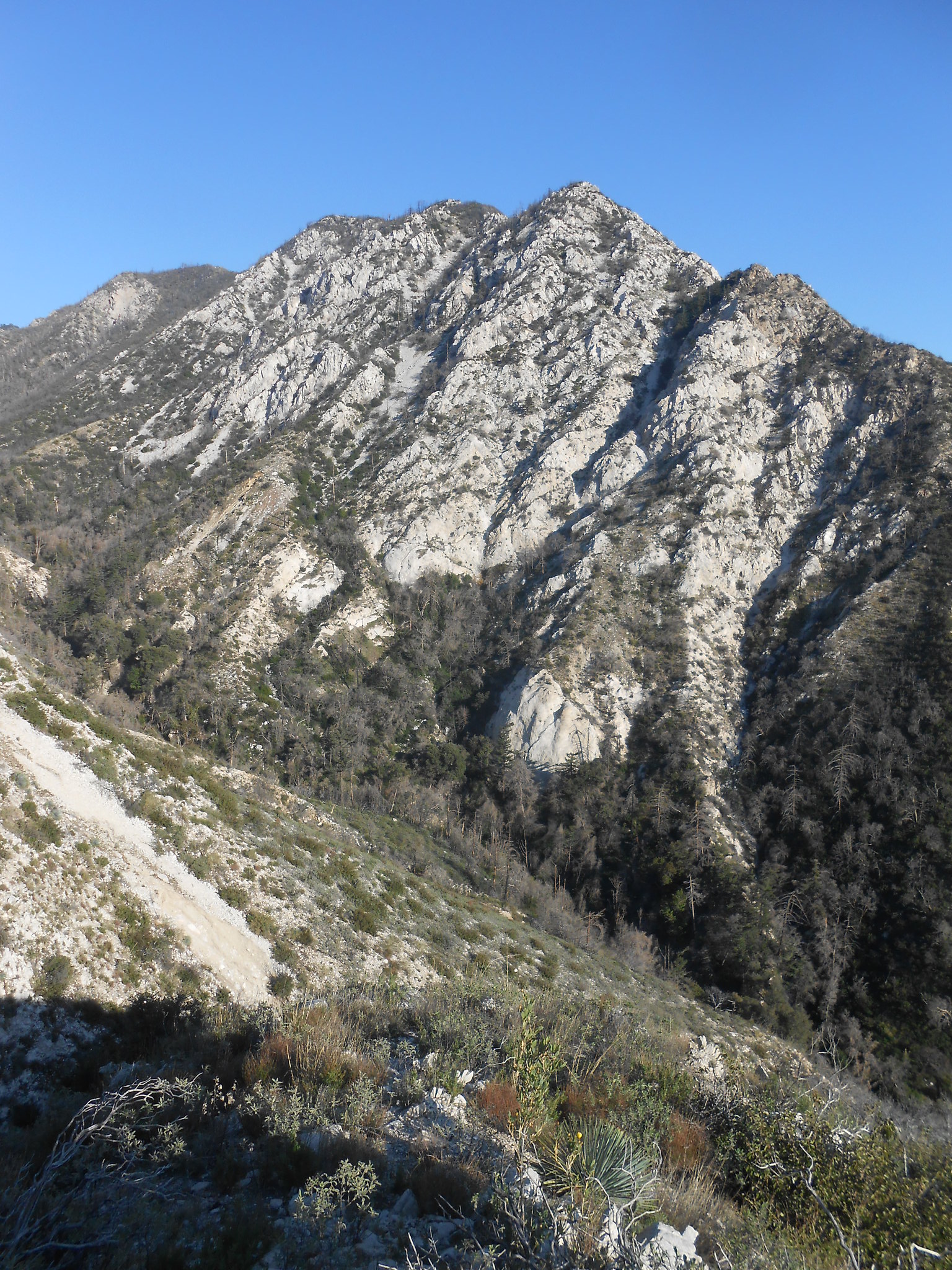
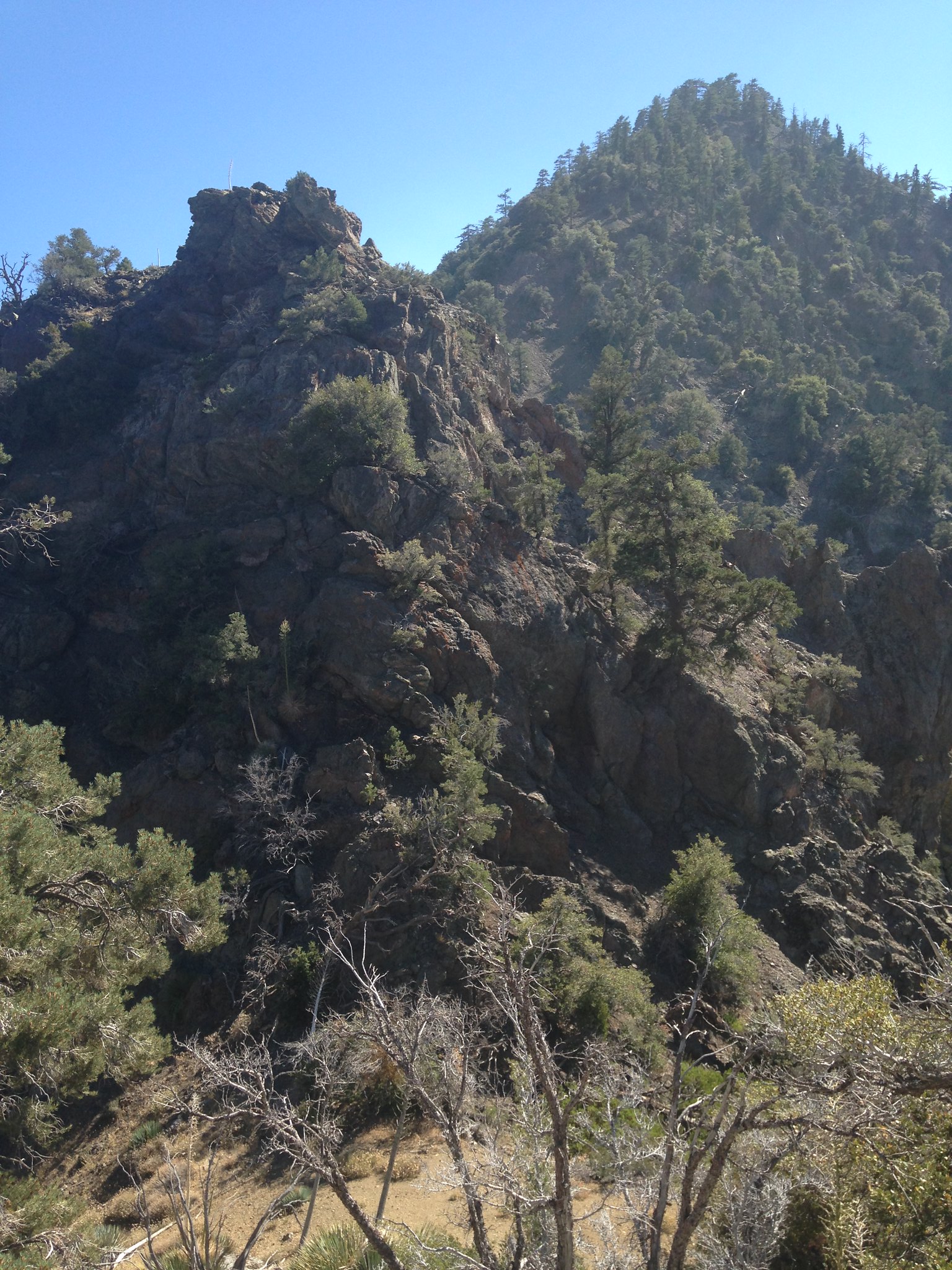
Here are two, just for fun.
Location number one:
Location number two:
Elwood
Posts: 617 Joined: Fri Aug 15, 2008 5:23 pm
Post
by Elwood Thu Jan 23, 2020 7:37 am
One kinda' looks like Mount Lowe and two looks like either that crappy downclimb to Rattlesnake or San Antonio Ridge.
David R
OG of the SG
Posts: 599 Joined: Sun Jun 12, 2011 10:28 pm
Post
by David R Thu Jan 23, 2020 8:31 pm
Peak 5,058 (I was also there) and NW ridge to Williamson. Pass to Sean.
dima
Posts: 1593 Joined: Wed Feb 12, 2014 1:35 amLocation: Los Angeles
Post
by dima Thu Jan 23, 2020 8:49 pm
Where's 5058?
Sean
Cucamonga
Posts: 4178 Joined: Wed Jul 27, 2011 12:32 pm
Post
by Sean Fri Jan 24, 2020 12:58 am
David R wrote: Peak 5,058 (I was also there) and NW ridge to Williamson. Pass to Sean.
I think you meant the
NE ridge . Dima, do a search for peak 5058.
Here are a couple slightly easier ones for those who haven't guessed correctly yet.
#1
Hint: This peak is within a six-mile radius of Baldy. Bonus: Where am I standing?
#2
Hint: There are two peaks visible in the distance. Bonus: Where am I standing?
walker
Posts: 248 Joined: Mon Apr 08, 2013 11:14 pm
Post
by walker Fri Jan 24, 2020 7:08 am
David R wrote: Peak 5,058 (I was also there) and NW ridge to Williamson. Pass to Sean.
Dang, nailed it! - but NE ridge. ?
dima
Posts: 1593 Joined: Wed Feb 12, 2014 1:35 amLocation: Los Angeles
Post
by dima Fri Jan 24, 2020 11:37 am
We're looking at 5058 from the North? That's Little Bear Canyon in front of it?
Uncle Rico
Posts: 1466 Joined: Thu Mar 20, 2008 7:48 pm
Post
by Uncle Rico Sat Jan 25, 2020 8:21 am
I'll take a stab Sean.
Sean
Cucamonga
Posts: 4178 Joined: Wed Jul 27, 2011 12:32 pm
Post
by Sean Sat Jan 25, 2020 9:53 pm
Nope, I guess we can open it up to anyone, since there aren't many of us guessing.
Elwood
Posts: 617 Joined: Fri Aug 15, 2008 5:23 pm
Post
by Elwood Mon Jan 27, 2020 6:38 am
How about Dawson from the Fish Fork Trail and Burnham, Baden-Powell from Ross.
dima
Posts: 1593 Joined: Wed Feb 12, 2014 1:35 amLocation: Los Angeles
Post
by dima Mon Jan 27, 2020 12:35 pm
Baden-Powell is bald, as seen from Ross...
Elwood
Posts: 617 Joined: Fri Aug 15, 2008 5:23 pm
Post
by Elwood Mon Jan 27, 2020 3:13 pm
As well would I be as seen from Ross. Or anywhere else in the San Gabriels.
AW~
Posts: 2077 Joined: Mon Oct 01, 2007 12:00 pm
Post
by AW~ Mon Jan 27, 2020 3:40 pm
I'll second Ross...but I think Copter Ridge
David R
OG of the SG
Posts: 599 Joined: Sun Jun 12, 2011 10:28 pm
Post
by David R Mon Jan 27, 2020 3:45 pm
#2 is Sadie Hawkins and South Hawkins probably from Middle Hawkins, dunno about #1 thought Pine but the ridge line and incline is all wrong.
Sean
Cucamonga
Posts: 4178 Joined: Wed Jul 27, 2011 12:32 pm
Post
by Sean Mon Jan 27, 2020 10:49 pm
AW~ wrote: I'll second Ross...but I think Copter Ridge
The first one looks like Icehouse....so looking at the topo, Sugarloaf?
Copter Ridge is right. That's where I'm standing in #2, looking north with Hawkins in the distance and Throop barely visible on the right edge. You have the right canyon for #1 so I'll give it to you: it's actually Timber from below Cedar Glen.
Your turn, AW!
AW~
Posts: 2077 Joined: Mon Oct 01, 2007 12:00 pm
Post
by AW~ Wed Jan 29, 2020 3:02 pm
OK, lets go difficult then...the one in the background left is named. The 2 in the foreground are not. And this view is from close to the ACH. The background one is in SBNF admin of the ANF...and maybe you can notice down bottom center there is a major road