Raining below the hut, windy, drizzle, and cold above the south ridge to the summit, 2-6 inches of slushy snow, but tonight will bring more snow, that which has been traveled on will freeze tonight, more snow expected, more rain expected below the hut.
Be safe, bring all the equipment and hope that the snow is soft enough to enjoy and travel across without having to put on the crampons to early.
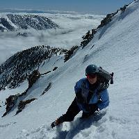
The wind gust on top were in the 35-40 range, spent less than ten minutes on the summit. Rim ice is thick on the trees, it's falling off as the temperature rises around noon, be aware that there's some huge chunks, some of it was three feet long point north east and then curled upwards from there, that's how brisk the wind is during this storm.
I just heard from a group that went up today starting from Manker. There is snow from Manker to the summit and it is deep and powdery. Too much to take the bowl, they went West Bowl and trail down.
They also said the road from Ice House to Manker was really icy and chains were mandatory. What time you going to be there tomorrow? I'm thinking 7-8am to get the road defrosted a bit. Or maybe Bear Canyon.
In keeping with the "conditions tomorrow?" thread...
I'm hoping to take my wife and kids snowshoeing up Icehouse Cyn for a couple miles. Since getting the family rolling early is a challenge, I was figuring on hitting the exit from 210 shortly before 8:00. Is that too late to park at Icehouse on a Holiday Monday after snowfall?
Great idea! 8am might be ok hard to say. 7am on New Years Day Manker was filling up fast so I would guess Ice House filled up too. Parking in the morning was much easier than driving out in the afternoon. That took hours to get back to the 210.
Gotcha. I don't mean to step on toes, but isn't that the south side? The West Bowl of Baldy actually starts near Coldwater Canyon near Iron Mountain, and forms the west face.
Taco wrote: Gotcha. I don't mean to step on toes, but isn't that the south side? The West Bowl of Baldy actually starts near Coldwater Canyon near Iron Mountain, and forms the west face.
Taco, you are right, it is left side of the bowl. It appears to veer northwest from the hut whereas the trail heads due west across the bottom of the bowl before going uphill.
So I guess the bowl side of the mountain doesn't face west at all. I think I meant the direction you walk/climb/slog in. I say think I meant because now I can't really remember.
The SA ridge side faces west on the other side of the hill (can I call Baldy a hill?).
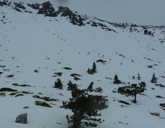
Maybe you have witnessed this phenomenon, Sunday was my first experience. I had a later than usual start up the ski hut trail and when i got to the bowl witnessed my first Conga Line to the top. Not having worked on my Latin dance moves in a while i headed west (or south Taco!) since i was intimidated by their footwork Crazy insane vision! We counted 35 climbers in the Conga Line at one time ascending Zen Chute.
Second weirdest thing... we were alone on the summit and only passed about 8 hikers coming down. Where did they all go?... Havana?
Interesting post Norma. I went up Saturday, started early, and did not see another person until I was about 60% up the bowl, they were at the bottom. I did notice several very fast moving rock and ice missiles zinging past as I ascended, including one softball sized ice chunk that passed between my legs (that was as close as I came to dancing).
On my return I took one look at the 40+ people coming up, each with the potential to knock an ice chunk loose and decided there was no way I was going down with my back to them. I took the long way back, some fun deep snow in the trees.
Tracie is correct...Aetherians do not summit!
If anyone is interested there were three shallow slides that probably fell from the rocks above.
Frank, your photo posted on the Whitney board of a similar line of hikers is way better than mine. You should post it here. The slide in this photo closest to foreground made us take a double-take as we descended. We, Mark and I, didn't remember seeing it in the morning. I looked back at my pix and i did not have a shot of that section of the bowl since i was focused on the Conga Line. Do you know if that happened Sunday? The slide with the rocks (furthest back) was there Tuesday.
p.s. just re-read your post. you were there Saturday. nevermind!...
Hello. I am new to the forum. Thanks for all the great information being provided here.
I live in the high desert and I want to take my son who is 7 hiking in the Baldy area. We have been doing a lot of desert hikes and I am getting anxious to get back into the mountains, especially with the recent warm weather. I just wanted to get an idea of the current conditions before I make the drive.
I was either thinking the Ski Hut Trail or Icehouse. We do not have crampons/snowshoes so we cant trek into icy areas. As far as the Ski Hut Trail I gather that we should be fine up to the ski hut. For Icehouse it looks like we should be ok to Icehouse Saddle. Can anyone confirm this?
Thanks for any input. I would hate to get his hopes up about a new hike and not be able to safely proceed. If we can't make it up we will probably hit up JTree!