Stanley-Miller Mine via Wetwater Trail

TRs for the San Gabriel Mountains.
Post Reply
User avatar
Blaise
Posts: 24
Joined: Sat Nov 17, 2018 5:46 pm

Post by Blaise »

I've had the idea of doing this hike for a while, and I finally got the opportunity yesterday. The plan was for my Dad and me to hike to the Narrows from the Bridge to Nowhere trailhead and head up to the narrows, where I hoped I could take a look at and attempt the Wetwater Trail, then follow it, hoping it would take us around to the Stanley-Miller Mine. All the info for the Wetwater Trail I had to go on was this picture (CLICK) and John Robinson's description of "The airy Wetwater Trail, terror of the pack mules with its dripping water, was hacked out of the cliffs above the Narrows to gain access (to the Stanley-Miller mine)" Using the 1950s topo map, I was able to get a pretty good idea of where it went. I attempted to scout out this route about a month ago but was forced to turn around just a couple hundred feet from the start of the mine trail by the high river at an especially dangerous crossing.

We started at 6 o'clock and made it to the hobo hut and Oliver Justice's cabin ruins before 9. From the river, we already had a pretty good view of the trail (or what was left of it).

We started up the direct route for the Stanley-Miller mine and then cut across to the trail when we were high enough. Finally, we were on the Wetwater Trail!
IMG_9288.JPG


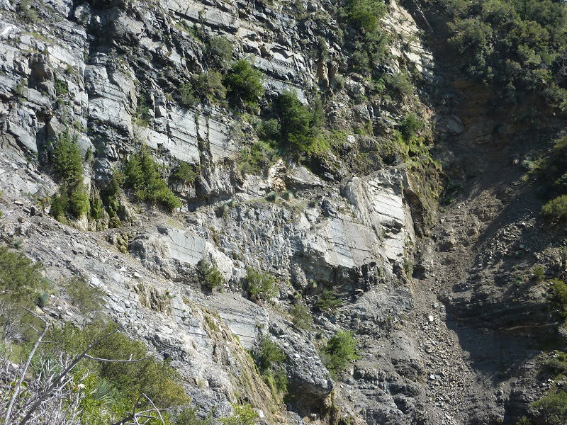
The views (and the exposure) were incredible.
IMG_9297.JPG
IMG_9299.JPG


This super exposed section is still all there, hacked out of the sheer cliff by Ben Miller, Stanley's partner in the mining operation. It is generally 2-3 feet wide, with some narrower points. A fall here means falling 300+ feet to the river below. The trail wasn't much wider when it was made than it is now, yet somehow the miners were able to haul up tons of machinery on this trail. There are two points where water flows over the trail, making the rock slippery and giving the trail its name.


IMG_9304.JPG
After this section, the trail stays near the cliff but is wider and less exposed. We found the remnants of a pack that looked like it had been baking in the sun for centuries, as well as some rusted metal. There were no signs of a recent visit to this trail. After a while it veers south, away from the cliff and comes to a dead end in a sea of bushes and trees that are so dense that you practically have to swim through it, rarely placing your feet on the ground. The next two and a half hours we spent bushwhacking up the mountainside, about 1000 verticle feet in elevation from where we lost the trail. Once we were at the right elevation, we cut across, heading north towards the mine until we hit the big steel pipe the runs up and down the hill. From there we descended about 400 feet in elevation until we came to the ruins of the mill and the mine.

The mine is surprisingly large, with several branching passages that loop around. There is even a significant second level that isn't too hard to climb up into.

There's the famous ore cart, which is in very good condition.
IMG_9323.JPG

The mine seemed fairly stable in general, but the end of one passage had a significant cave-in. It looked like the passage continued beyond it, but we didn't attempt it.
IMG_9339.JPG
IMG_9345.JPG


In 1953, the mill's supports burned in a forest fire, sending the mill and much of its equipment crashing down to the bottom of the canyon 1000 feet below. The mountainside is still littered with parts of the mill.

After taking a quick look at the significant remains of the mill foundation and its equipment, we headed north to the cabin. On the way, we saw some stone walls, either shoring or foundations. We also found the large stove, now covered in spring flowers. Soon we were at the cabin and we took some photos and had a break before heading down. There was still a significant amount of metal artifacts, pots, and pans, but not as many as I'd seen in older posts about the mine and cabin.

From the cabin, we descended following a cable part of the way and shooting for the hobo hut. The descent is very steep, descending over 1000 feet in about a third of a mile.

On the way back in the while about to cross the river in the narrows, we had a scare. A big rock shot out from the cliff above our heads and exploded on the opposite wall of the canyon, sounding like a gunshot. We ducked for cover as more rocks came down into the river around us. Just another reminder of how dangerous canyons like that can be. From there, it was just six miles of river crossings and trekking back to the trailhead.

Overall, I would say the trip was a great success. The Wetwater trail is no shortcut though. I would be interested to see if the trail continues at all past the place where it hit a dead end in the sea of vegetation. We just headed straight up the mountain after we lost the trail, but we did see some potential signs further away of a trail continuing further on. We never rejoined any sort of trail until we found the pipe above mine and mill. It also seems like there's no good route to the mine unless a 2-3 hour bushwhack/1000 foot climb is your thing. It has also been said that Oliver Justice was buried 'on a hill behind his cabin.' Would that mean that he could be buried somewhere along the trail? In any case, his 90-year peace hasn't been disturbed yet.
User avatar
Blaise
Posts: 24
Joined: Sat Nov 17, 2018 5:46 pm

Post by Blaise »

Here are some more photos from our adventure.
IMG_9363.JPG

The old stove, now covered in flowers.

IMG_9369.JPG

The cabin as it looks now.
IMG_9374.JPG

IMG_9386 (1)-PANO.jpg
The water that gave the Wetwater trail its name. (from below)
User avatar
Sean
Posts: 3748
Joined: Wed Jul 27, 2011 12:32 pm

Post by Sean »

Thanks for the report! That's a cool bit of old trail. I can't think of any other SGM trails with that much of a rock overhang.
User avatar
tekewin
Posts: 1194
Joined: Thu Apr 11, 2013 5:07 pm

Post by tekewin »

Cool discovery and great report. Doesn't look like much of a trail in that first photo, and other photos where I can make out a trail, it doesn't look like much of a trail. I don't think it would be my preferred approach. Nice mine photos, too. Glad there were no mishaps along the way.
User avatar
Blaise
Posts: 24
Joined: Sat Nov 17, 2018 5:46 pm

Post by Blaise »

tekewin wrote: Doesn't look like much of a trail in that first photo, and other photos where I can make out a trail, it doesn't look like much of a trail. I don't think it would be my preferred approach.
Yes this definitely isn't the fastest way to the mine. I did want to check out this trail specifically because it was the historic route to the mine and I was hoping to find more of the original trail still there. Also just because it's such a cool section of trail. The trail up the cliff is fairly decent though, and as long as you're careful, it should be safe enough. Unfortunately, it appears as if the trail is too overgrown past a certain point to follow anymore.
User avatar
dima
Posts: 1319
Joined: Wed Feb 12, 2014 1:35 am

Post by dima »

Thanks for writing this up! Every time I'm in that canyon I look over at the wall, trying to find signs of the trail, and it was never clear to me where it was. Super cool to see the remaining chunks. Have you ever tried to find the old trail between Stanley-Miller and Allison mines? That's another one that's probably long gone.
User avatar
Blaise
Posts: 24
Joined: Sat Nov 17, 2018 5:46 pm

Post by Blaise »

dima wrote: Have you ever tried to find the old trail between Stanley-Miller and Allison mines? That's another one that's probably long gone.
I've never tried. This is actually only my second Iron Mountain mine, I got the Gold Dollar back in November. Have you seen any signs of a trail from the Allison Mine to the Stanley-Miller in your explorations? There are probably parts of it still left, but brush is probably a major problem.
Screen Shot 2019-04-28 at 9.09.50 PM.png

Here's where the trail is in the 1955 topo map. (As a side note, I circled where the Wetwater trail is. We lost it about where the switchbacks start.)
User avatar
dima
Posts: 1319
Joined: Wed Feb 12, 2014 1:35 am

Post by dima »

I maybe found the start of it a few weeks ago near Allison mine (allison-mine-to-iron-mountain-t8026.html). Haven't followed it though. If anything is still there, there would be a LOT of brush, as you say. Thanks for the map, I'll look next time I'm there!
User avatar
CrazyHermit
Posts: 343
Joined: Mon Sep 07, 2015 1:03 pm

Post by CrazyHermit »

Just put up a new Stanley Miller video. Still haven't tried the Wetwater Trail.

User avatar
Gene
Posts: 197
Joined: Mon Dec 26, 2011 7:54 pm

Post by Gene »

Whoa! The video quality is top level, excellent job!

"The best yet, excellent video and very "arty" the view at 14:06 would have made Ansel Adams jealous."

I think the compressor was actually a hit miss engine, e.g.:
Post Reply