
*Had trouble embedding the video. Here is a link to our trip*
Wrightwood to Vincent Gap via Prairie Fork
Some time gone and several other trips into upper Prairie Fork allowed for exploring Upper Fish Fork camp & bag Wild View Pk/Pine Mt Ridge. Still never going further than Lupine Campground.
Enough putting things off. Another buddy answered the call and we met at the "face-lifted" Baden Powell parking lot. Left one car here & drove over to the also "face-lifted" Acorn Trailhead parking. Very nice all around I must say. Up the Acorn Trail, always gorgeous, making me wish I had this access in my backyard. Crossed paths with a few PCT hikers. We walked north on the Blue Ridge Road one bend & dropped onto a mellow ridge that connected us down to the lower road (3N39) leading into Lupine CG. Easy travel on game trails, perfect views of Pine Mt.
Had lunch at Lupine Campground. Memorial Day weekend (Saturday) saw 4 sites taken. Stout rigs from Jeeps to 4Runners making it over the rough washout mid canyon. Onward down the old road. Earlier assuming this was going to be hot & a "sprint to Cabin Flat" to find water, but it turned out to be a wild flower madhouse! Whole sections of the road were full of Lupine & Indian Paintbrush. Definitely the best display I've ever seen in the Gabes. Anyone have info on the fire history in this area?
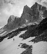
Below Lupine Campground
Down at Cabin Flat it was a different story. Over head high chaparral surrounded the camp. Bathrooms fairly intact still. We wandered back and worth looking for the right way to broach all the vegetation accessing the creek. Many low level game trails looked hard & a bit to early in the trip too be crawling. The key was to go east of the bathroom about 30 yards and look for the overgrown car camp site on the right. While in the camp, looking down canyon from that site there is a large fallen/burnt tree with a brown plastic "Wilderness Marker" (boy scout trip report below has a photo of this spot). Go to that marker and the path will reveal itself. Godspeed.
First water. Bear prints on both sides of the creek.
Filtering water & assessing the absolute 180 degree turn in vegetation we now were facing, things became slower & more focused. Fortunately the good folks at EisParaten.com had some insight on the now "off trail" adventure we are in. There are varying degrees of which travelers have felt about the 2ish miles between Cabin Flat & Vincent/Mine Gulch. The local legend that is Elwood made pretty quick work of the area. Knowing his hiking depth, we were not going to be on his level for pace. Right up there with Elwood is HeadSizeBurrito who also is quite the serious hiker. His account of this area turned out to be the most spot on while knowing his abilities. Lastly, the true champs, the boy scouts that battled this section on their high country mission. Between these three reports & all the lovely bad decisions in San Gabriel canyons prior, assumption of a rough, but memorable time was to come.
Not bad travel
Old road bed?! Anyone with info? Not far below Cabin Flat
After breaking into the interior, the old path would reveal itself often. More so than either of us had expected. The one thing this portion did take was both of us pretty much constantly looking for the signs of a "walked path" on ground (smashed leaves, broken tree branches, small crunched rocks). Not to say it was hard, but vigilance really kept the backtracking to a serious minimum (& thrashing very light). We never bushwhacked into anything ominous the entire time & if we ever faced that, it meant we had just made a wrong move about 15 ft back almost every time. Re-check & locate the route.
It worked well to cross the creek & find the flood plains & old stream beds
The sun went behind Baden in the last little stretch before meeting Vincent Gulch. This portion was a bit more braided with lots of paths through more of a chaparral setting. Without expecting it we were standing right next to the broken down trail sign that had sparked my interest so many years ago. It had taken us 2 hours and 40 minutes to go from Cabin Flat to the confluence with a couple solid breaks to enjoy the remoteness. The mellow pace in this part turned out to be the true success, keeping frustrating fails that we had expected to an amazing minimum. No fires in the backcountry anyways, so why not walk till late evening.
Surprisingly not a soul around, we had the Mine Gulch trail camp to ourselves & welcomed the solitude.
Mine Gulch trail camp. 4.5 mylar balloons on this outing.
Nothing eventful on the way out via Vincent Gulch Trail the next morning. Saw the plane wreck from a distance, no need to see it up close again. Stopped off at Vincent's Cabin for a last little break in the pines before city things. Wrightwood was a buzz for the holiday weekend when we headed back to pick up the other car.
Successful all around. Hope this info helps others & inspires some to check the less visited corners of the local mountains.

