JMunaretto wrote:Need a decent hike this weekend, and haven't bagged Josephine or Lawlor, so might as well go for a big loop. I don't want needless miles however, so I'm not sure if there's any benefit to taking the fire road as opposed to the Colby Canyon trail.
Tentative for Saturday
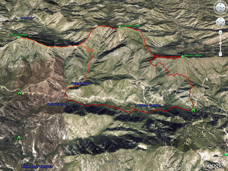
Park at CC trailhead (or Switzers) and head up to Josephine saddle ~ 2 miles
Head west, ideally along SE ridge all the way to Josephine as opposed to the trail, has anyone done this? ~1.5 miles
Back to Josephine saddle ~ 2 miles
Up Strawberry's west face, and down to Strawberry-Lawlor saddle ~ 2.5 - 3 miles
Up Lawlor ~ .75 miles
Down Lawlor to Redbox ~ 3 miles (I don't want to take that south ridge all the way down, but is the lower portion less harsh than the upper? It appears the trail intersects with the ridge at an obvious point as shown on the map).
Redbox to Switzers/Colby trailhead ~4 miles
Seems like a 13-14 mile hike. Estimates reasonable? If I ascend the Josephine fire road instead of CC, will that add to mileage?
Joseph: I think you'd do better by hiking from the Colby Canyon trailhead. I think it's nicer than going up the fire road. Fire road =

.
When you hit the ridge, you'd have to turn left (west) to hit Josephine and then back track to the point where the trail up Colby Canyon comes in. The backtracking adds some mileage, but just based on a gut feeling, you might come out about equal since the fire road is a much longer way to reach the Josephine - Strawberry ridge.
Also, when you get to Switzer's, it's not far from where the little road down into Switzer's hits ACH to get to Colby, so you wouldn't need a car shuttle. There is a trail from Switzer's to the Clear Creek Information Station which is very near to where the fire road to Josephine starts, so if you did choose the road, you still wouldn't need a car shuttle.
The descent from Lawlor to "pole saddle" is pretty steep on crappy DG, and there is some yucca, but I don't think the yucca is particularly bad. It's certainly doable; I've seen and/or read about people doing it. I suppose it would just depend on the group. It would definitely be a significant time savings.
I haven't ever directly gone up to Josephine from the east, so I can't comment on the brush or anything like that.
Even though it's not supposed to be particularly hot this weekend, I'd get an early start on the Colby Canyon trail (or the fire road). It's pretty exposed and can be unpleasant on a sunny day. Based on your past TR's, I'd bet that you would get an early start anyway, but I thought I'd mention it. That trail is no fun at all on a summer's day unless you start really early.
Sounds like a good hike. The ascent up the class 3 west ridge of Strawberry is a favorite of mine. Have fun!
HJ


 [/u]
[/u]