
I'm curious about what condition the Ken Burton Trail is in. It climbs from the Oakwilde trail camp in the Arroyo Seco up to Brown Mt. Fire Road (I think that's what it is called). Any info would be appreciated - even if it is old info. Also interested on whether there is a trail from the CGC Ridge down to Oakwilde TC. And while I'm in the area, any one know if it is possible to ascend the west ridge of Brown Mt.? Easy, hard, bushwhack???
Not finding much info by searching (FAIL!), so thanks in advance.
Ken Burton Trail
-
Hikin_Jim

- Posts: 4688
- Joined: Thu Sep 27, 2007 9:04 pm
The Ken Burton trail links the Arroyo Seco with the Brown Mtn Fire Road. I don't believe there's a trail from CCC ridge down to Oakwilde. Three used to be a route up Dark Canyon, but I haven't been up it in years. Last I heard it had gotten heavily washed out.
Here's a current USGS topo snippet:
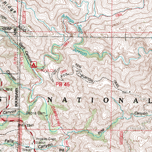
The map shows the Ken Burton Trail pretty accurately as it climbs from Oakwilde to the Brown Mtn Fire Road.
The map also shows a route going up Dark Canyon, but you'd have to scout that yourself. Like I say, last I heard it was washed out by a fairly big landslide.
As for an ascent up Brown Mtn via the W Ridge, I can't really say. I know there's a use trail from Tom Sloan Saddle to the summit, and I recall seeing a faint use trail continuing west from the summit, presumably linking up with the Ken Burton Trail, but I haven't actually taken the West Ridge myself.
Here's a current USGS topo snippet:
The map shows the Ken Burton Trail pretty accurately as it climbs from Oakwilde to the Brown Mtn Fire Road.
The map also shows a route going up Dark Canyon, but you'd have to scout that yourself. Like I say, last I heard it was washed out by a fairly big landslide.
As for an ascent up Brown Mtn via the W Ridge, I can't really say. I know there's a use trail from Tom Sloan Saddle to the summit, and I recall seeing a faint use trail continuing west from the summit, presumably linking up with the Ken Burton Trail, but I haven't actually taken the West Ridge myself.
-
HikeUp

- Posts: 4107
- Joined: Thu Sep 27, 2007 9:21 pm
Thanks HJ. That agrees with what I've been able to find as well as what I remember from my only visit to Brown Mt. via Tom Sloan Saddle. I only have a few hours to play with this weekend so I might explore how to get to Oakwilde from ACH - satellite images have given me a couple ideas.
-
Hikin_Jim
- Posts: 4688
- Joined: Thu Sep 27, 2007 9:04 pm
Here are some conditions postings on a MTB forum:
http://www.socalmtb.com/socal/trails/br ... st=reviews
Here is a video of the Ken Burton Trail:
This hiker appears to have gone down the West Ridge of Brown: http://outdoors.webshots.com/album/5585 ... Cd?start=0
This Summitpost write up indicates that it's possible to ascend Brown Mtn. from the Ken Burton Trail http://www.summitpost.org/view_object.p ... _id=224172
Here, you can pick up the steep east ridge [I think they mean going east on the west ridge] of Brown Mountain and follow it about 2 miles with 1600 feet of gain to the summit (4,466 ft.). Alternatively, you can hop onto the Ken Burton Trail (a wooden sign marks the start) which trail takes you on a 3 mile descent into Arroyo Seco Creek.
-
Hikin_Jim
- Posts: 4688
- Joined: Thu Sep 27, 2007 9:04 pm
Gotcha. I'd be curious as to what you find out. As I recall, the route down Dark Canyon was fairly steep. Here's a view of the section in question:HikeUp wrote:Thanks HJ. That agrees with what I've been able to find as well as what I remember from my only visit to Brown Mt. via Tom Sloan Saddle. I only have a few hours to play with this weekend so I might explore how to get to Oakwilde from ACH - satellite images have given me a couple ideas.
Christopher Brennan has an alternative to the Dark Canyon route described here http://www.dankat.com/advents/ccccyn.htm. The route he describes sounds more like the route I took. I don't know, but I wonder if he describes his Twin Canyon route because the Dark Canyon Route is so difficult. Complete speculation on my part.
I just Googled the current edition of Trails of the Angeles. I did a search inside on "Dark Canyon." I found the following:
This quote is consistent with my memory.The historic Dark Canyon Trail is temporarily impassable because of a massive slide.
When you do decide to head up the W Ridge:
-
JMunaretto
- Posts: 370
- Joined: Thu Feb 07, 2008 11:03 am
Funny b/c as I've driven up the ACH, I wondered what that trail was going up the west side of Brown. If you check it out in gEarth (or gMaps I suppose), that trail is quite visible (as it is from what I saw from the ACH).
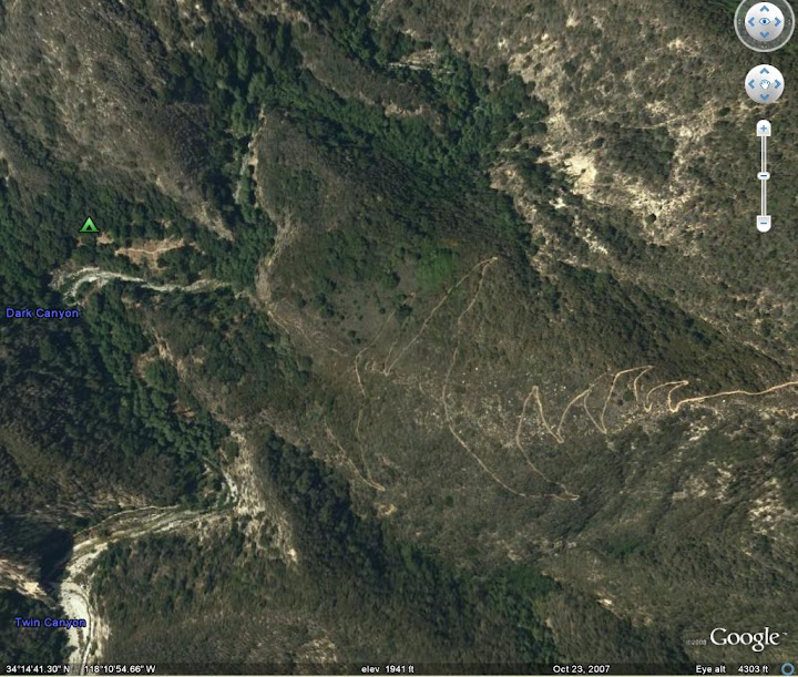
As for coming off that ridge down into Dark Canyon, you can pretty clearly see a trail for the first part of the descent heading west, but the trail seems to disappear (either under trees or gone!).
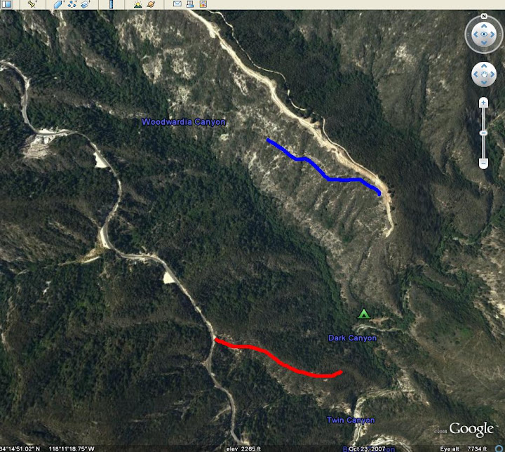
If you also look around the red, there appears to be a use trail heading down, but I'm not sure if it goes all the way down.
As for coming off that ridge down into Dark Canyon, you can pretty clearly see a trail for the first part of the descent heading west, but the trail seems to disappear (either under trees or gone!).
If you also look around the red, there appears to be a use trail heading down, but I'm not sure if it goes all the way down.
-
cougarmagic

- Posts: 1414
- Joined: Wed May 07, 2008 5:21 pm
The Twin Canyon trail is the way to go - I've been down it a few times. It's short, fast, and easy to follow. Gets you to Oakwilde in probably 15 minutes. It's hard to find the turnout where it starts though - maybe Matt knows the mile marker for it?
Been curious about the Ken Burton trail myself...I'd like to go, but I think I have to work on Saturday.
mountain bikers claim to have seen a mountain lion on the top of that trail, where it meets the Brown mountain fire road, several times...but who knows, don't believe everything you read on the internet....
but look for tracks!
-
HikeUp
- Posts: 4107
- Joined: Thu Sep 27, 2007 9:21 pm
Thanks everyone.
Joe, that red route you show is what I was going to explore. It clearly goes out to the power line tower, and it looks like some trace of a trail heads north down towards Oakwilde. Is this what you guys are referring to as the Twin Canyon route? or is that actually IN Twin Canyon further to the south of the red route?
Joe, that red route you show is what I was going to explore. It clearly goes out to the power line tower, and it looks like some trace of a trail heads north down towards Oakwilde. Is this what you guys are referring to as the Twin Canyon route? or is that actually IN Twin Canyon further to the south of the red route?
-
cougarmagic
- Posts: 1414
- Joined: Wed May 07, 2008 5:21 pm
Yes - the route in red is the so-called "Twin Canyon Trail". Once you're on it, you can't miss it or take any wrong turns. it takes you right down there. A couple of steep sections, but nothing to worry about.
-
Hikin_Jim
- Posts: 4688
- Joined: Thu Sep 27, 2007 9:04 pm
I think the red line in Joseph's sat photo is the old Dark Canyon Road on CCC Ridge. The Twin Canyon Route is further south.
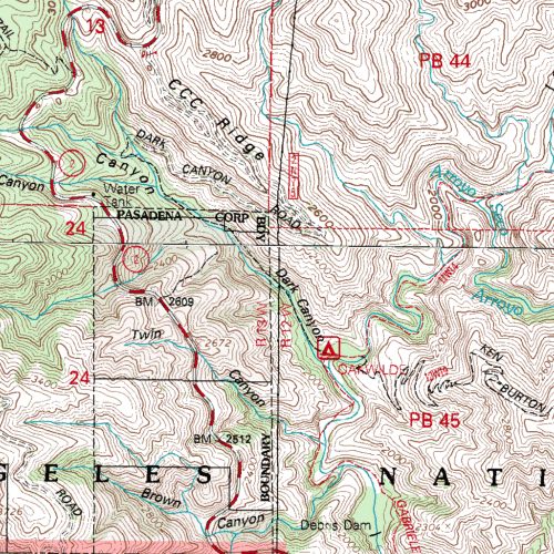
This map might be helpful:

The old Dark Canyon Road on CCC Ridge is shown first in Red and then in pink as it heads to Oakwilde. The Twin Canyon route, shown in pink, starts at the mouth of Dark Canyon and heads steeply (as I recall) up this side, meeting the road (ACH) at Twin Canyon. The more I think about it, the more sure I am that the route I took last I was there was the Twin Canyon route.
This map might be helpful:
The old Dark Canyon Road on CCC Ridge is shown first in Red and then in pink as it heads to Oakwilde. The Twin Canyon route, shown in pink, starts at the mouth of Dark Canyon and heads steeply (as I recall) up this side, meeting the road (ACH) at Twin Canyon. The more I think about it, the more sure I am that the route I took last I was there was the Twin Canyon route.
-
JMunaretto
- Posts: 370
- Joined: Thu Feb 07, 2008 11:03 am
The CCC ridge on your map is the ridge above the blue line in my pic, I believe. You can also line up the red line in my map based on the 2 loop sections of the ACH with the ACH on your map
-
Hikin_Jim
- Posts: 4688
- Joined: Thu Sep 27, 2007 9:04 pm
Hmm. OK, I should've looked more closely at those photos.JMunaretto wrote:The CCC ridge on your map is the ridge above the blue line in my pic, I believe. You can also line up the red line in my map based on the 2 loop sections of the ACH with the ACH on your map
-
Hikin_Jim
- Posts: 4688
- Joined: Thu Sep 27, 2007 9:04 pm
Time for some Acmefu: The ridge that Joseph marked with a red line clearly has a trail going from the ACH at approximately "A" down to the transmission line towers at "B." Beyond "B," one can see what appear to be traces of trail at "C," "D, and "E." I can't make it out completely, but a trail could then wind down to point "F" where another trace of what appears to be a trail exists, and then perhaps from there to the Gabrieleno Trail, appropriately marked with a "G."
Other notes: I've marked the start of the Ken Burton Trail with an "H." If one follows the trail up (generally east) from there, one can see that in fact there is a faint use trail on the west ridge of Brown Mtn. It might be an interesting hike to start at Millard CG, hike up to the Dawn Mine and then Tom Sloane Saddle, then proceed to Brown Mtn, descend the west ridge and then take the fire road back to Millard CG. Sounds doable but a fair number of miles. Nice winter hike if you want something snow free.
Other notes: I've marked the start of the Ken Burton Trail with an "H." If one follows the trail up (generally east) from there, one can see that in fact there is a faint use trail on the west ridge of Brown Mtn. It might be an interesting hike to start at Millard CG, hike up to the Dawn Mine and then Tom Sloane Saddle, then proceed to Brown Mtn, descend the west ridge and then take the fire road back to Millard CG. Sounds doable but a fair number of miles. Nice winter hike if you want something snow free.
-
Hikin_Jim
- Posts: 4688
- Joined: Thu Sep 27, 2007 9:04 pm
Doh!  Now I'm embarassed. The route that Joseph ID'd in the sat photo looks like it is the Twin Canyon route. If you look at that last Acmefu I posted, the traces do indeed appear to be the trail if you compare them to Brennan's posted map:
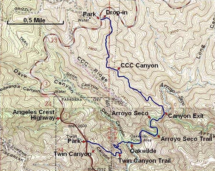
The LA Trails.com map that I posted and referred to earlier shows an entirely different route. Brennan's maps are usually very accurate. I'd bet on Brennan, particularlly since the sat photo corroborates Brennan. I guess the LA Trails.com map should be used as more of a catalog of trails than as an exact representation of their location.
Interestingly, Brennan's map shows a trail proceeding into the canyon area from BM 2609.
-
HikeUp
- Posts: 4107
- Joined: Thu Sep 27, 2007 9:21 pm
You can see that as a purple trace on the ACME topo too. No sign of it on the sat photo.Hikin_Jim wrote:Interestingly, Brennan's map shows a trail proceeding into the canyon area from BM 2609.
OK, enough of this. Time to go see things for myself. Don't know when though.
More info than I could have ever expected - thanks!
-
Augie

- Posts: 345
- Joined: Fri Sep 28, 2007 2:17 pm
There is definitely a use trail trail on Brown Mtn's west ridge. It is steeper than the east ridge route to the summit (that's my page on Brown Mtn. on SummitPost).
I have done the route someone mentioned: Millard Campground to Dawn Mine to Sloan Saddle, up the east ridge to Brown Mtn summit, down its west ridge and finally the long boring fire road (about 6 miles) back to Millard Campground.
One of my favorite trail runs is the Brown Mtn Fire Road from Millard Camground to the junction with the Burton Trail. Sometimes I run a little ways (about a mile) down the Burton Trail and back up.
I mountain biked the Ken Burton Trail down to Oakwilde about 5 years ago. It was a fun descent with lots of tight switchbacks. Once down to the river bed, turn left and there is Oakwilde. I started and ended at the JPL/Windsor Gabrielino trailhead. Don't know what conditions on the Burton trail all the way down are currently.
About 2-3 years ago I tried to descend down to Oakwilde from the CCC ridge. It didn't take long before I got to an impassable part. At that time, there was a sign at the start of the trail that basically said the trail is washed out and unstable.
-
Hikin_Jim
- Posts: 4688
- Joined: Thu Sep 27, 2007 9:04 pm
Hey, Augie, have you got a total mileage for that loop?Augie wrote:There is definitely a use trail trail on Brown Mtn's west ridge. It is steeper than the east ridge route to the summit (that's my page on Brown Mtn. on SummitPost).
I have done the route someone mentioned: Millard Campground to Dawn Mine to Sloan Saddle, up the east ridge to Brown Mtn summit, down its west ridge and finally the long boring fire road (about 6 miles) back to Millard Campground.
I've got a friend coming out in January, and I'm looking for a good two day backpack. The Brown Mtn loop wouldn't be ideal, but perhaps a side trip to camp at either Bear Canyon or Oakwilde would make a nice backpack.
If we had an extra day, we might even be able to head up from Millard CG to Bear Canyon TC the first day, Oakwilde the 2nd day, and then hike up the Ken Burton and back to Millard CG on the 3rd day.
-
mattmaxon

- Posts: 1137
- Joined: Mon Mar 24, 2008 12:48 pm
The last time I was out on the Ken Burton Trail was 3/24/2005, it was in decent shape then.
Like Jim sez the map for once is accurate! How'd that happen?
The Dark Canyon Trail is an old road grade, and while there are slides from 2005 deluge I personally wouldn't consider it impassable. The segment in the canyon is a canyon bottom boulder hop/scramble
This map shows what I call the "Twin Canyon Trail" while it is really an XC route it is shorter than Dark Cyn by a long way and probably in better shape. I last used this a few months ago.
Chris Brennen's map is an approximation not done with a GPS
As to Brown Mtn, I don't know looks doable let us know what you find!
Matt
-
Hikin_Jim
- Posts: 4688
- Joined: Thu Sep 27, 2007 9:04 pm
Hi, Matt,
Thanks for posting that more exact map and for posting the mile marker number.
HJ
Thanks for posting that more exact map and for posting the mile marker number.
HJ
-
mdougherty
- Posts: 3
- Joined: Tue Nov 11, 2008 10:45 pm
I did the Brown Mountain Loop as Augie described back in March. It's hike 21 in the most recent edition of Trails of the Angeles. Robinson writes that it's 12 miles with 2500 feet of gain, which sounds about right to me. It's a nice hike, aside from the aforementioned fire road, which does get fairly tedious.Hey, Augie, have you got a total mileage for that loop?
I understand you can or once could find the grave stone of one of the Brown brothers up there somewhere, but I don't know precisely where.
-
Hikin_Jim
- Posts: 4688
- Joined: Thu Sep 27, 2007 9:04 pm
Only 12 miles? That's not too bad. Hmm. I'm going to have to do that loop.mdougherty wrote:I did the Brown Mountain Loop as Augie described back in March. It's hike 21 in the most recent edition of Trails of the Angeles. Robinson writes that it's 12 miles with 2500 feet of gain, which sounds about right to me. It's a nice hike, aside from the aforementioned fire road, which does get fairly tedious.Hey, Augie, have you got a total mileage for that loop?
There have been a number of access disputes in Altadena where long established trails cross private land. A popular hike was to go to the Brown boys' grave markers. A landowner tried to stop people from coming on to his land to see the grave markers, which caused a lot of controversy. "Mysteriously," the grave markers just up and disapeared in the middle of the controversy. There's strong suspicion that the land owner "took matters into his own hands" but no one can prove anything.mdougherty wrote:I understand you can or once could find the grave stone of one of the Brown brothers up there somewhere, but I don't know precisely where.
I saw the markers once. I guess I'm lucky.
-
Augie
- Posts: 345
- Joined: Fri Sep 28, 2007 2:17 pm
Those stats are my estimate as well. Jim, could be mighty wet in the Arroyo to Dawn Mine or in Bear Canyon in January. Ah, but that's part of the adventure.mdougherty wrote:I did the Brown Mountain Loop as Augie described back in March. It's hike 21 in the most recent edition of Trails of the Angeles. Robinson writes that it's 12 miles with 2500 feet of gain, which sounds about right to me. It's a nice hike, aside from the aforementioned fire road, which does get fairly tedious.Hey, Augie, have you got a total mileage for that loop?
I understand you can or once could find the grave stone of one of the Brown brothers up there somewhere, but I don't know precisely where.
The gravestone of Owen Brown is not along the above route.
-
HikeUp
- Posts: 4107
- Joined: Thu Sep 27, 2007 9:21 pm
Info on Owen Brown Grave...Augie wrote:The gravestone of Owen Brown is not along the above route.
http://www.altadenatrails.org/kingday2007.html
-
JMunaretto
- Posts: 370
- Joined: Thu Feb 07, 2008 11:03 am
Okay I'm gonna be checking out a bunch of this Saturday. Gonna start of the ACH and take down the Twin Canyon use trail to Oakwilde, pick up the Ken Burton trail, then ascend the west ridge to Brown Mountain.
After, will likely continue east all the way to Mt. Lowe. Then, turn around the same way we came, or make a loop down to Dawn Mine, Millard Campground, and some combinations of fireroad/trail back to Oakwilde.
After, will likely continue east all the way to Mt. Lowe. Then, turn around the same way we came, or make a loop down to Dawn Mine, Millard Campground, and some combinations of fireroad/trail back to Oakwilde.
-
HikeUp
- Posts: 4107
- Joined: Thu Sep 27, 2007 9:21 pm
I was thinking the same thing for Saturday (or maybe Sunday). At least up to Brown - I'd reverse the route to return to the car.JMunaretto wrote:Okay I'm gonna be checking out a bunch of this Saturday. Gonna start of the ACH and take down the Twin Canyon use trail to Oakwilde, pick up the Ken Burton trail, then ascend the west ridge to Brown Mountain.
After, will likely continue east all the way to Mt. Lowe. Then, turn around the same way we came, or make a loop down to Dawn Mine, Millard Campground, and some combinations of fireroad/trail back to Oakwilde.
Have you estimated mileage and gain yet?
-
JMunaretto
- Posts: 370
- Joined: Thu Feb 07, 2008 11:03 am
my quick estimations:
out and back to brown, 8-9 miles, 3500 ft gain.
all the way to lowe, 14 miles 5000 ft.
out and back to brown, 8-9 miles, 3500 ft gain.
all the way to lowe, 14 miles 5000 ft.
-
HikeUp
- Posts: 4107
- Joined: Thu Sep 27, 2007 9:21 pm
My estimate agrees with that. Thanks. Might see ya out there.
-
JMunaretto
- Posts: 370
- Joined: Thu Feb 07, 2008 11:03 am
well I'm still debating this. I haven't been on the trails on these routes so don't know how much danger there would be with snow, but then I think the snow level might not be much until ascending Lowe. I'm split on doing t his versus some hike I mapped on on the backbone trail in Santa Monica mtns...
-
Uncle Rico

- Posts: 1486
- Joined: Thu Mar 20, 2008 7:48 pm
Was up at the saddle yesterday where the Ken Burton trail intersects with the Brown Mountain fire road and ran into a couple of Forest Service folks. They had come up the Ken Burton Trail from the Arroyo Seco and said that the trail, although imperfect, was passable the entire way and that its re-opening was imminent. Take that for whatever it's worth.
I didn't think to ask until after they had already left the status of the Gabrieleno Trail through Long Canyon to Switzer.
I didn't think to ask until after they had already left the status of the Gabrieleno Trail through Long Canyon to Switzer.
-
dima

- Posts: 1941
- Joined: Wed Feb 12, 2014 1:35 am
- Location: Los Angeles
That is very good to know; thanks. Opens up a number of loops. As for the Gabrielino, from Oakwilde to where the trail leaves Long canyon it's relatively open. There's a bit of brush and some deadfall, but it's very passable overall. I haven't been on the section where the trail traverses between Long canyon and Switzer's, but I heard that's passable as well.