GPS discussion

Clothes, tools, technology, nutrition, training, techniques, etc.
Post Reply
User avatar
AlanK
Posts: 1069
Joined: Thu Sep 27, 2007 9:28 pm

Post by AlanK »

There have been several discussions recently related to the accuracy of GPS receivers. One opinion that has been expressed several times is that handheld or wrist GPS receivers can't possibly work well. I have presented some empirical evidence to the contrary. For example, I measured the distance to the 1 and 2 mile markers on the Lower Sam Merrill Trail in Pasadena. These markers are general regarded as accurate. My Garmin Forerunner 305 GPS watch measured 1 and 2 miles to better than 1%. I thought that was a nice little test. Even if you question the accuracy of the mile markers, the fact that the GPS readings up and down agreed to better than 1% by itself shows that the random errors that people talk about with GPS are smaller than 1% (with respect to cumulative distance) under good conditions.

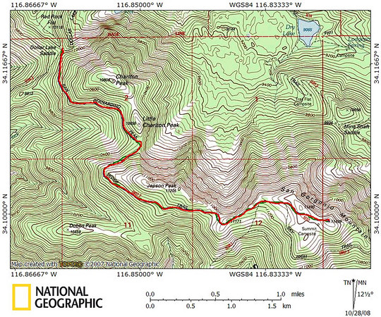
Here is another simple test. The map below shows a hike from Dollar Lake Saddle to the summit of Mt. San Gorgonio. There are three traces. One (green, 3.52 miles) is a trace of the trail on the map, drawn as accurately as I could make it. The others are tracks from the aforementioned GPS watch going up (red, 3.53 miles) and down (blue, 3.56 miles). The traces agree remarkably well and the distances agree to about 1%. You can talk all you want about random errors, arm motion, etc. This is an empirical example of what those errors actually mean. For hiking purposes, a portable GPS receiver performs wonderfully well under a wide variety of conditions (in my experience).

Image

There has also been discussion of the relative accuracy of GPS receivers and measuring wheels. As I clearly stated on another thread, I don't care which is inherently more accurate. A wheel is certainly better on a smooth surface, although it can be problematic on a rocky trail. But it is a silly "issue." I have met thousands of people hiking and never seen one with a measuring wheel. I have met hundreds of people who themselves have met thousands of people without encountering one with a wheel. If 1 out of 1,000,000 (or 100,000 or even 10,000) people hike with a wheel, they are the exception that proves the rule. People don't rely on wheels to measure their hikes. Tom Harrison may have used a wheel to measure some trails for his maps, but even those cases are exceptional. For those of us who go off-trail, the whole business of measuring wheels is moot.
User avatar
JMunaretto
Posts: 370
Joined: Thu Feb 07, 2008 11:03 am

Post by JMunaretto »

Another way to evaluate accuracy when doing out and back hikes is to calculate the average error between the out and back tracks quantitatively. Given that data points are not collected at the same locations, some interpolating needs to be done, but it should work.

I took a brief jaunt to Switzer Falls and comparing tracks to each other and topo could easily see that in the tighter spots, and especially in the canyon bottom, the error increased relative to the rest of the trail (obvious). I'll have to post that, but still pretty accurate.

As for the swinging phenomenon, right now GPS are not at the accuracy to where that would even have an effect. When they do, I would imagine it would not be too hard to filter out given its frequency.
User avatar
HikeUp
Posts: 3861
Joined: Thu Sep 27, 2007 9:21 pm

Post by HikeUp »

Let's expand the discussion to how accurate GPS (ones that do not use altimeters) is at determining elevation and cumulative elevation gain/loss.

My understanding is that GPS units are better at determining longitude and latitude than altitude due to triangulation issues (I'm not convinced why this would be the reason. I also do not have a link or a source for where I read this). I assume elevation is determined by triangulation versus some database of elevations vs. x-y coordinate.

Empirically, I have seen elevation profiles that have a lot of static, noise, or whatever you call it. Seems like that bouncing up and down can add up to quite a bit of error in the accumulative gain/loss. The trend of the profile certainly looks very good, so perhaps a filter could be used to smooth the data before the gain/loss is calculated. This seems to be a software issue instead of a GPS issue and could also apply to distance (as Joe mentioned regarding arm swinging).
User avatar
Hikin_Jim
Posts: 4686
Joined: Thu Sep 27, 2007 9:04 pm

Post by Hikin_Jim »

I guess it would also matter as to which model of GPS one were to use. I understand that some of the newer models work a lot better under tree canopies and in canyons than the older models.

The route from Dollar Lake Saddle to the summit of San Gorgonio is high, relatively straight (vs. a lot of tight switchbacks), and fairly open (if I recall correctly), all of which are good conditions for a GPS unit. I imagine that down in the bottom of the Arroyo Seco below Switzer Falls, a GPS unit would be less accurate.

I also wonder what the accuracy would be on switchbacks. For example, if we approach the summit from Mine Shaft Saddle instead of Dollar Lake Saddle. Would a GPS unit be as accurate?

Still, Alan's results are significant. He's shown that a GPS can have a high degree of accuracy on trail. I'm just curious about exceptions to that accuracy.
User avatar
mattmaxon
Posts: 1137
Joined: Mon Mar 24, 2008 12:48 pm

Post by mattmaxon »

AlanK wrote:There have been several discussions recently related to the accuracy of GPS receivers.
One major factor in the accuracy equation is the chipset the unit is based on.

SiRF II used in the newer units has superior sensitivity essential for maintaining sat lock under tree and brush cover

This is enhanced when combined with an external antenna which generally amplifies the signal as well.

Since GPS is line of sight when I want maximum accuracy I place this antenna at the highest point near me (the top of my head)

Since WAAS now has additional sats over the continental US WAAS corrections can be received in many many more areas further improving accuracy, I now mostly have "D" on all sats most of the time.

While not survey quality GPS (cm) this IMO is plenty good (1-3m)

My totally unscientific observations of GPS vs Barometric elevations on my unit(s) is they mostly agree, this is assuming a bomber sat lock and "D"'s galore

Apparently the GPS elevation is a good indication of the quality of the position quality, or the bigger the error (elev) the worst the position fix.

But even with SA enabled if you need to know roughly where you are a 3 sat fix is gonna get you somewhere in the ball park, with a map, compass, & altimeter most competent adventurers can pin point their position, assuming they have no clue where they are.

Matt
User avatar
AlanK
Posts: 1069
Joined: Thu Sep 27, 2007 9:28 pm

Post by AlanK »

JMunaretto wrote:Another way to evaluate accuracy when doing out and back hikes is to calculate the average error between the out and back tracks quantitatively. Given that data points are not collected at the same locations, some interpolating needs to be done, but it should work.

I took a brief jaunt to Switzer Falls and comparing tracks to each other and topo could easily see that in the tighter spots, and especially in the canyon bottom, the error increased relative to the rest of the trail (obvious). I'll have to post that, but still pretty accurate.

As for the swinging phenomenon, right now GPS are not at the accuracy to where that would even have an effect. When they do, I would imagine it would not be too hard to filter out given its frequency.
I have lots of GPS data, as do many others. I have slowly been playing with analyzing pieces of it but it is a slow process. Also, my motivation is not high because there are many good discussions of GPS accuracy out there (I mean technical ones, not conversations with a Garmin customer service rep).

What I was trying to do with my recent posts was to use simple examples to dispel the notion that inherent random errors (e.g., due to arm swinging) are a problem for use with hiking.

I can certainly show tracks that are less accurate than the one I used. A discussion of such tracks, and how to know when there are problems, is worthwhile and I would be happy to contribute. But I first wanted to get past the idea that the things don't work well most of the time -- they do.

For my examples, I picked the trail to Echo Mountain because its distance is well-known and it has many switchbacks. To compare a track with a trail, I picked San Gorgonio because I know that trail segment has not changed since the map data were accumulated many years ago.

Overall, as I've said that in earlier posts, a GPS unit is not always 1% accurate for distance measurements. But, in my experience, is is almost accurate to a couple of percent, which is, in my opinion, good enough for hiking.

Finally, as I have also said before, the thing about arm swinging is that the error involved (a) is tiny and (b) tends to cancel out because the overestimates are balanced by underestimates.
User avatar
AlanK
Posts: 1069
Joined: Thu Sep 27, 2007 9:28 pm

Post by AlanK »

mattmaxon wrote:
AlanK wrote:There have been several discussions recently related to the accuracy of GPS receivers.
One major factor in the accuracy equation is the chipset the unit is based on.
...
Matt -- you are a great addition to this board. I would love to meet you some time and talk at length. I have been posting mostly about "good enough for hiking" GPS use and have concentrated for now on integrated distance estimates. You actually discuss getting greater accuracy out of GPS, which is a more complicated subject and worthy of even more (and more arcane?) discussion.

I did some analysis of elevation data from my John Muir Trail hike in 2006. I'll try to dig it up. I found that the distribution of elevation data (compared to known elevations) was Gaussian with a standard deviation that was about what was listed in the manual for my eTrex receiver. As you said, with good sat lock, the data were fine.
User avatar
mattmaxon
Posts: 1137
Joined: Mon Mar 24, 2008 12:48 pm

Post by mattmaxon »

AlanK wrote: There has also been discussion of the relative accuracy of GPS receivers and measuring wheels. As I clearly stated on another thread, I don't care which is inherently more accurate. A wheel is certainly better on a smooth surface, although it can be problematic on a rocky trail. But it is a silly "issue." I have met thousands of people hiking and never seen one with a measuring wheel. I have met hundreds of people who themselves have met thousands of people without encountering one with a wheel. If 1 out of 1,000,000 (or 100,000 or even 10,000) people hike with a wheel, they are the exception that proves the rule. People don't rely on wheels to measure their hikes. Tom Harrison may have used a wheel to measure some trails for his maps, but even those cases are exceptional. For those of us who go off-trail, the whole business of measuring wheels is moot.
I bought a wheel and compared it directly to my GPS, the values agreed within 0.04 miles every time over distances of 8-16 miles.

As to the GPS I personally agree. If I say I got value X for distance and tell someone to go that distance they will get to the right spot without a waypoint

I do feel however for off trail / XC accurate elevations are more important

"Go south on the ridge to 3250ft and follow gully on right down to 3145ft "
yada yada yada is more useful.

Matt
User avatar
simonov
Posts: 1087
Joined: Tue Nov 27, 2007 5:44 pm
Location: Reno, NV
Contact:

Post by simonov »

I've had very bad luck with my GPS, but I seem to have narrowed the problem down to the antenna.

I don't know why a small GPS would be any less accurate than a bigger one, since as Matt indicates it's all about the chipset and antenna. I find my GPS is worthless if I wear it on my chest or belt where I can get to it easily, because the antenna is not good enough to get accurate readings through my body. On the other hand, I get pretty accurate tracks if I attach it to the top of my pack, where it is otherwise of no practical use to me on the trail.

I'd like to play some more with GPS, but I won't until I get a unit with a better antenna or a detachable one I can put in my hat or my pack.
Nunc est bibendum
User avatar
JMunaretto
Posts: 370
Joined: Thu Feb 07, 2008 11:03 am

Post by JMunaretto »

So my question is, as a GPS newbie, what are you using to compare known elevations to recorded? I have that Garmin Software in which you use their topo or upload others, and I know you can place routes on their that use their topography, but I'm not yet sure how to take recorded tracks that have their own elevation data to also get another estimate from the topo maps.

Further, all I am exporting are .gpx files, which contain lat/lon/ele track points. The elevation points are from the altimeter, and nowhere do I see elevation estimates alone from GPS triangulation. Can I get this information out?

Sorry this is a little off topic, if anyone could suggest a good forum for these sorts of questions I would appreciate it.

One personal interest in elevation estimates is to evaluate energy expenditure, which doesn't need to be evaluated in real time. I don't have the data on me, but I have plotted cumulative elevation gain as a function of time and filtering (ghetto moving average filter until I do some resampling of data to fixed intervals). Obviously the unfiltered data will estimate high cumulative gains as any +/- 5 ft error will just add up as more gain.

For instance, doing the C2C hike, I believe my unfiltered estimate of gain was like 12,000 ft. Averaging with 1 point on each side reduced the estimate to about 11,000. Ideally, I would take a trail that has a lot of ups and downs and a good high-res topo map and figure out what sort of filtering best fits topo estimates.

That's why it would be interesting to use various methods of estimating elevation to come up with a 'best estimate'. Using topo maps / altimeter / gps triangulation together in some algorithm would work well, I don't know what's been done with this.
User avatar
AlanK
Posts: 1069
Joined: Thu Sep 27, 2007 9:28 pm

Post by AlanK »

Joe -- your questions are good ones and someone like Matt can probably answer them off the top of his head. I need to dig a bit. I recall having (for the JMT) abut 100 data points at known elevations obtained by writing down GPS readings in a notebook. That distribution is the one I mentioned earlier. I also played with many more data points from gpx files but never completed that analysis because I had too many more immediately interesting things to do. If I find time, I will look up my files on that subject.

The use of GPS vs barometric altimeter data is interesting. As I recall from reading ~10 years ago, some GPS units use internal barometric altimeters to smooth data but don't use altimeter data exclusively. I'm sure there are different approaches in different instruments, and things have probably evolved in the past decade. I need to do some reading. Again, Matt probably knows this stuff backward and forward.
User avatar
mattmaxon
Posts: 1137
Joined: Mon Mar 24, 2008 12:48 pm

Post by mattmaxon »

Joe
In general GPS units don't record the data to do the Post Processing needed to do what you want to do

Can't do it with track data. Or waypoints for that matter

There is a consumer level Post Processing package from delorme.

GPS PostPro 2.0

When I start out I try to calibrate the barometric altimeter to a known elevation.

These come from various sources, but mostly from USGS maps, I do try to access survey data from various city and government agencies for bench marks and spot elevations, these would be more accurate than what is on the maps.

I happen to know the elevation at my computer at home is 1325 ft and check it by having it on as I pass intersections with x or BM VABM elevations...

Hope this helps
Matt
FIGHT ON

Post by FIGHT ON »

Let's measure a "trail" using a gps.
How accurate could it be?
Well you be the judge.
Let's use the Garmin Forerunner 305 model.

To be fair and above all "accurate" let's be specific on where the placement of the gps is to be in relation to the trail.
Also let's say you will measure trails in the San Gabriel, San Jacinto, San Gorgonio mountains.
Let's put it on your wrist.
Also let's say you hike on the trail to be measured at no slower than 2mph and no faster than 5 mph.
How far is the wrist above the surface of the trail?
You would have to measure that distance.
Whatever that distance is must be consistent to be accurate.
Hiking while not moving your wrist to maintain that distance? You figure that out!
But, you would have to hike in such a way to maintain that margin to be accurate.
If you use hiking poles then your wrist also moves up and down as you complete each stride.
That motion would not follow the "trail" contours.
Attempts to calculate and cancel out this motion would be the same as trying to be accurate with a pedometer. Pedometers are approximate, not accurate because your stride changes. It's not consistent. At best you would end up with some "approximation". And we are not talking about being approximate.
The Forerunner 305 is inaccurate according to the manufacture. Anyone can call the Garmin and they will tell you.
Draw a circle around where ever the gps unit is. Any of the Garmin units.
That circle is 18 feet from one side to the other. This circle represents an area where the folks at Garmin say is where the Forerunner 305 could take a reading. Anywhere in that circle. And that's when it's working at it's best.
When enough satellites are in view. Trees, cloud cover, adjacent vertical objects such as steep terrain could block them to further make matters worse. The unit does not alert the user to when it does not have enough in view with a audible beep or flash other than something on the screen. You would have to be looking at it all the time to see if and when it does. I guess then you would have to stop and wait until you get enough satellites and then go on. To be accurate.
What does happen if you don't notice it is that it draws a straight line from when it lost reception to when it regains reception. And as you know, trails don't go that way.
Then there is the fact that trails don't incline at a straight line either. Trails go up and down.
This unit does figure in that info but like the 18 foot circle that goes around, there is an error perimeter circle that goes above and below the unit. That one is a bit bigger. 100 feet. 50 feet below and 50 feet above where ever the gps unit is. To me that's not accurate.

Then there is .01 experiment as being accurate.
.01 of a mile? That's 52.8 feet!
So measuring a trail and being within .01 on the return confirms accuracy?
What part of 52.8 feet was it off?
To me it confirms how inaccurate it is.
So the way I see it is this.
You have a unit that is not reliable for measuring distances on uneven surfaces such as the trails. The trails are there. They have a distance. Measuring them with a Forerunner 305 is inaccurate.

Some day when it does become accurate. You would have to drag it on the trail to get the correct information.
But for now if you are looking for general, approximate, indefinite,
rounded off information, then gps is for you.
And if you want to know how long a trail is, use a wheel. No batteries required!
User avatar
Tim
Posts: 560
Joined: Tue Apr 08, 2008 8:55 pm

Post by Tim »

I don't have a clear answer on the GPS altitude question, but I wanted to mention another issue with GPS altitude besides just accuracy of the triangulation.

GPS altitude is reported as the height above a theoretical ellipsoid (HAE). This ellipsoid is known as the WGS84 datum. However, this datum isn't the mean sea level (MSL) because MSL is not uniform due to variations in the gravitational field on earth. Fortunately we do have a mathematical model of MSL known as the Geoid. Some GPS receivers have a grid implemented inside where they can obtain the WGS84 geoid height over the WGS ellipsoid from the current position. Then they are able to correct the height above WGS ellipsoid to the height above WGS84 geoid. So some GPS units and chipsets may or may not do this correction and/or some may do it better than others. Also, it's not clear which units do this or do not (except I do know starting with V2.3.3 on SiRFII , V2.1.1 on XTrac, and V3.1.0 with SiRFstarIII, the Geoid separation is now reflected in GGA field 9 to show MSL altitude).

Topo maps are based on the National Geodetic Vertical Datum of 1929 or NAVD 88. This datum is defined by the observed heights of mean sea level at 26 tide gauges and by the set of elevations of all bench marks resulting from the adjustment. This datum was not mean sea level, the geoid, or any other equipotential surface.

So you might be asking, why don't the manufactures just correct the GPS HAE altitude to NAVD 1929 or NAVD 88? I don't know. Maybe the difference isn't important enough to worry about in a consumer product. The main thing to understand is that by default GPS reports altitude above the WGS84 ellipsoid. If you compare this altitude to other frames of references like MSL or topo maps that use other datums, there could be disagreements between the reported values.

Btw, I agree with Matt about the chipset issues. I have a Vista HCx and there have been a lot of complaints about drift and odometers errors in this unit (which I've also experienced). Many blame it on the chipset because it's a high sensitivity chip (but not a SiRF chip), but this also means it's more likely to sample poor signals and process it incorrectly. My older 60CS seems to be more accurate and reliable but it lost signal all the time in difficult areas. There is also a weird issue with the baro altimeter on my Vista HCx and I don't trust it anymore. I now load my GPS with topo maps with 40 ft or even 20 ft contours and just read the elevation off the contour line.

Joseph, for GPS message boards, try GPSpassion.com, the geocaching.com forums or http://gpsinformation.org/forum/index.php
User avatar
Hikin_Jim
Posts: 4686
Joined: Thu Sep 27, 2007 9:04 pm

Post by Hikin_Jim »

Matt, out of curiousity, what model of GPS do you have?

Tim, compared to the elevation shown on a topo map, about what difference would a GPS show due to the geoid etc. issue? In other words, would a GPS show something 10' off of what the contours show? 20'? 100'? Would the difference shown be consistent or would it vary? I assume consistent. Would the GPS generally show a higher elevation value or a lower elevation value.

I'm just trying to get a bound on the magnitude of the issue here.
User avatar
mattmaxon
Posts: 1137
Joined: Mon Mar 24, 2008 12:48 pm

Post by mattmaxon »

Hikin_Jim wrote:Matt, out of curiousity, what model of GPS do you have?
Garmin GPSmap76CSx is my current GPS
User avatar
Tim
Posts: 560
Joined: Tue Apr 08, 2008 8:55 pm

Post by Tim »

Hikin_Jim wrote:Tim, compared to the elevation shown on a topo map, about what difference would a GPS show due to the geoid etc. issue? In other words, would a GPS show something 10' off of what the contours show? 20'? 100'? Would the difference shown be consistent or would it vary? I assume consistent. Would the GPS generally show a higher elevation value or a lower elevation value.

I'm just trying to get a bound on the magnitude of the issue here.
To be honest, I don't really know. I haven't done any experiments to compare GPS calculated elevation against topo maps or known benchmarks. People use to say that GPS derived altitude could be off by hundreds of feet. I'm not sure if the newer units are like this. I've never paid that much attention to GPS altitude because conventional wisdom used to be that baro altitude is more accurate than GPS derived altitude if it's calibrated to a known elevation or local baro pressure. Since my GPS units have all had baro altimeters I've always use the altimeter to determine elevation. I guess I'm not really a GPS power user so I've never looked that closely at how accurate everything is. Most of the time it's good enough for my purposes, which is only light duty use and no data collection.

Btw, my Vista HCx and the newer Garmin units have an auto-calibrate feature for the baro altimeter. No one really knows exactly how this works but it seems to tweak the altimeter reading to the GPS elevation. The following comes from Dale DePriest's downloadable PDF e-book "A GPS User Manual - Working With Garmin Receivers":
The automatic GPS calibration is not described in Garmin documentation, but here are some observations. Above about 15,000 feet it will correct the altimeter fairly rapidly once you have a lock fairly rapidly. On the ground it assumes you should be within 1000 feet of where the altimeter says you are and if the GPS altitude shows a bigger difference than that the unit will wait for you to correct it. Within 1000 feet it applies the GPS correction averaged over time and will correct half the error in about 22 minutes on an exponential curve that will eventually converge to the correct altitude. If you power it up with a different altitude after having been off for a while it will correct it in about 5 minutes. Of course if you don’t have a 3D fix the altimeter altitude will be trusted to display a 3D solution. As a matter of fact these units never display the GPS computed solution and always indicate a 3D fix by using the built in altimeter. The tracklog also displays the altimeter altitude and this is what is used to display the vertical profile on the altimeter page.
My guess is the error would not be consistent. It depends on where you are geographically. The WGS 84 ellipsoid is basically a perfect shape (geocentric and globally consistent within ±1 m), while the Geoid varies up and down.
User avatar
AlanK
Posts: 1069
Joined: Thu Sep 27, 2007 9:28 pm

Post by AlanK »

One basic question that comes up regularly in discussing topo maps, GPS, etc. is whether, for a course with significant elevation gain/loss, the distance reported is the "horizontal" distance along the Earth's surface (which is close to flat for typical hikes) or the distance along the sloping path. In one of the recent discussions on this board, this "issue" was cited as another inaccuracy connected with GPS.

For the most part, this is a red herring. A typical hiking trail has an average slope of 10% (528 feet gained/lost per mile) or less. For a 10% slope, the distance traveled along the sloping path is 0.5% further than the horizontal distance. Even on a steep trail (1000' per mile), the distance along the path is only 1.8% longer than the horizontal distance. This may be worth noting, but few hikes are measured that accurately.

This brings up the question of how accurately one needs ot know hiking distances. The practical answer is usually "not very." I think that getting distances to 1-2% is doing well. I would be interested in other opinions.
User avatar
Hikin_Jim
Posts: 4686
Joined: Thu Sep 27, 2007 9:04 pm

Post by Hikin_Jim »

AlanK wrote:This brings up the question of how accurately one needs ot know hiking distances. The practical answer is usually "not very." I think that getting distances to 1-2% is doing well. I would be interested in other opinions.
Knowing distances to within perhaps 0.25 mi or possibly even 0.5 mi should be enough for decision making. Should I press on to the next camp before nightfall? Is it worth the side trip to get water? If I had GPS data that indicated the mileages, I think I could make reasonable decisions for the preceeding two questions. A greater degree of precision is unnecessary. We're not trying to fire a missle down Saddam Hussein's ventilation shaft here.
FIGHT ON

Post by FIGHT ON »

AlanK wrote:One basic question that comes up regularly in discussing topo maps, GPS, etc. is whether, for a course with significant elevation gain/loss, the distance reported is the "horizontal" distance along the Earth's surface (which is close to flat for typical hikes) or the distance along the sloping path. In one of the recent discussions on this board, this "issue" was cited as another inaccuracy connected with GPS.

For the most part, this is a red herring. A typical hiking trail has an average slope of 10% (528 feet gained/lost per mile) or less. For a 10% slope, the distance traveled along the sloping path is 0.5% further than the horizontal distance. Even on a steep trail (1000' per mile), the distance along the path is only 1.8% longer than the horizontal distance. This may be worth noting, but few hikes are measured that accurately.

This brings up the question of how accurately one needs ot know hiking distances. The practical answer is usually "not very." I think that getting distances to 1-2% is doing well. I would be interested in other opinions.
Well now, I finally agree with you Alan. If you want ot be "not very" accurate then use a gps to figure out how long a trail actually is! :wink:
User avatar
JMunaretto
Posts: 370
Joined: Thu Feb 07, 2008 11:03 am

Post by JMunaretto »

I think of being off by a mile or two total on a hike distance estimate is somewhat significant. But even with a 20 mile hike, you have to underestimate 5% per mile which won't come from the difference between horizontal and slope distances. 10% for 2 miles. Obviously, for a 10 mile hike, you would have to underestimate the difference by double % to get such error.
User avatar
AlanK
Posts: 1069
Joined: Thu Sep 27, 2007 9:28 pm

Post by AlanK »

JMunaretto wrote:I think of being off by a mile or two total on a hike distance estimate is somewhat significant.
I agree with this. On the other hand, for years the standard distance (e.g., in handouts from the USFS) listed for the Vivian Creek hike up San Gorgonio was short by over a mile. The standard distance for the South Fork hike was long by over a mile. Only a few people seemed to notice or care. :)
FIGHT ON

Post by FIGHT ON »

Abandon Ship!
I see the comments about gps SHIFTING from how accurate it is (realizing that it really isn't) to if it's off by a mile or so who cares! If it's off by a mile then why even use it?
User avatar
hvydrt
Posts: 494
Joined: Thu Sep 27, 2007 8:18 pm

Post by hvydrt »

AlanK wrote:On the other hand, for years the standard distance (e.g., in handouts from the USFS) listed for the Vivian Creek hike up San Gorgonio was short by over a mile.
What is the standard? I think I usualy track 7.6 to 7.8
User avatar
AlanK
Posts: 1069
Joined: Thu Sep 27, 2007 9:28 pm

Post by AlanK »

hvydrt wrote:
AlanK wrote:On the other hand, for years the standard distance (e.g., in handouts from the USFS) listed for the Vivian Creek hike up San Gorgonio was short by over a mile.
What is the standard? I think I usualy track 7.6 to 7.8
I usually get about 9.0 miles, but I measure from the lower parking low, where I usually park. I don't claim to have the definitive measurement of the official trail, but a couple of discussions on the SGWA board a couple of years ago came up with general agreement that the distance is over 8.5 miles, while the listed value was 7.5 miles. The official handout says 8.6 miles nowadays.

The trail on topo maps is about 7.5 miles, but it is no longer accurate. In one of those discussions, I identified over a mile of distance added when they put in the endless switchbacks above High Creek and a couple of long ones above Halfway.
User avatar
Tim
Posts: 560
Joined: Tue Apr 08, 2008 8:55 pm

Post by Tim »

I once measured VC on my 60CS and it also measured about 9.0 miles. I also park in the lower parking lot and that's where I started the odometer. I think it's reasonable to expect some variations in the odometer because this is a calculated value based on sampling position information at set intervals. I could see how certain algorithms could build up errors over time if you move at low speeds (unless you're AlanK) and if you stop and start often or if you mill about, moving back and forth in short distances as you take a break.

The distance and other calculated information is nice, but a GPS is primarily a positioning device. It does this very well and very accurately, especially if you have WAAS correction.
100 meters: Accuracy of the original GPS system, which was subject to accuracy degradation under the government-imposed Selective Availability (SA) program.

15 meters: Typical GPS position accuracy without SA.

3-5 meters: Typical differential GPS (DGPS) position accuracy.

< 3 meters: Typical WAAS position accuracy.
That's pretty incredible that we have positional accuracy down to less than 3 meters in North America with WAAS correction or 15 meters anywhere else in the world with just a consumer handheld device.
User avatar
AlanK
Posts: 1069
Joined: Thu Sep 27, 2007 9:28 pm

Post by AlanK »

Tim wrote:The distance and other calculated information is nice, but a GPS is primarily a positioning device. It does this very well and very accurately, especially if you have WAAS correction.
It's worth bring that point to the front once in a while! I am interested in total distance, but I would not say that it's terribly important. Knowing where you are is much higher up on the scale of useful stuff! :)
User avatar
HikeUp
Posts: 3861
Joined: Thu Sep 27, 2007 9:21 pm

Post by HikeUp »

Good point. I bought my cheapo Geko 201 gps unit because it could tell me where I was...on the map I was holding upside down usually.

I didn't buy the more expensive units to know distance or save a route - I can do that with Google earth or a topo afterward. I bought the cheapo as a sort of safety thingy. I can turn the WAAS on and have the thing tell me where I am within 10 feet or so. Based on that I know how far it is (miles and elevation gain) to my destination because I have my map with me. I'm just glad some one made the map I'm carrying.

My experience is that the thing does nail the distance traveled very closely if it can keep a signal (cheap piece of crap gets confused by trees though). I don't own software that can process the trace it records so I don't know how it does on elevation gains.

Arguments regarding how accurate the different measuring methods are need to be prefaced by definitions of what constitutes "accurate" (i.e. "what is is" as our last president so eloquently put it). Seems like our resident antagonist wants the distance measured to be within millimeters and include each and every climb we make over each and every pebble on the ground. On the other hand, the rest of the participants in this discussion seem to intuitively know what "accurate" means in the context of hiking - i.e. close enough not to fucking matter.

Change my title to "Get a map!".
FIGHT ON

Post by FIGHT ON »

HikeUp wrote: "Get a map!".
HERE HERE! :D
User avatar
AlanK
Posts: 1069
Joined: Thu Sep 27, 2007 9:28 pm

Post by AlanK »

HikeUp wrote:Arguments regarding how accurate the different measuring methods are need to be prefaced by definitions of what constitutes "accurate" (i.e. "what is is" as our last president so eloquently put it). Seems like our resident antagonist wants the distance measured to be within millimeters and include each and every climb we make over each and every pebble on the ground. On the other hand, the rest of the participants in this discussion seem to intuitively know what "accurate" means in the context of hiking
I tried to point out on an earlier thread that the idea that a trail has a fixed and knowable length is a false idea. People need to learn about the The Fractal Geometry of Nature, an idea that has been around for decades, even in the popular literature. If you measure what we think of as a 10 mile trail at the millimeter level, you will get a distance many times longer than 10 miles. If you measure it at the micrometer level, it will be many times longer still. A trail does not really have a length, or at least not a finite length. What we do is assign approximate lengths based on appropriate levels of precision.

Talking about how accurate measurements are is equivalent to talking about how inaccurate they are. In the case of hiking, we have the luxury of not caring about length, as determined on a human scale, to better than a few percent.
Post Reply