
There have been a lot of pot farm busts in the local mountains lately. One of the reports I read about pot farm busts said something about "unusual" trails, traffic, or trash where they shouldn't be as tip offs as to possible MJ farms.
I live near Haines Canyon and regularly hike the Sister Elsie Trail which generally follows Haines Canyon, eventually joining up with the Stone Canyon trail en route to Mt. Lukens. On the Sister Elsie trail, above where Forest Road 2N76 leaves the canyon bottom, there's a new trail that sort of "appeared" all of the sudden. The Sister Elsie Trail is largely abandoned. I don't think the FS even recognizes it as a trail anymore. Just a few locals/volunteers keeping it alive. And now a new trail. Heading off in a kind of random direction. I don't think it's some official effort. I followed it a bit before I got kind of spooked having read the article about pot farm tell tale signs. If you've ever cleared a trail through chapparal, then you'll know what I mean when I say someone really put some effort into this trail. Doesn't seem like a survey trail. It's certainly not a recreational trail put in by the FS. Couldn't be kids, not with that much work involved.
Anyway, maybe it's nothing. Just sort of stream of consciousness posting here (probably shows). Maybe I'll wander down that trail and give it a gander. Thought I'd post first and see if anyone knows anything.
Are things going to pot?
-
FIGHT ON
I doubt it would have been created by mj farmers or the like. Why would they want to create a clear trail toward their farm that more people could find and follow? Attracting more people toward their activities seems against their mo. but then again, those involved with drugs aren't thinking right to begin with so who knows.Hikin_Jim wrote:There have been a lot of pot farm busts in the local mountains lately. One of the reports I read about pot farm busts said something about "unusual" trails, traffic, or trash where they shouldn't be as tip offs as to possible MJ farms.
I live near Haines Canyon and regularly hike the Sister Elsie Trail which generally follows Haines Canyon, eventually joining up with the Stone Canyon trail en route to Mt. Lukens. On the Sister Elsie trail, above where Forest Road 2N76 leaves the canyon bottom, there's a new trail that sort of "appeared" all of the sudden. The Sister Elsie Trail is largely abandoned. I don't think the FS even recognizes it as a trail anymore. Just a few locals/volunteers keeping it alive. And now a new trail. Heading off in a kind of random direction. I don't think it's some official effort. I followed it a bit before I got kind of spooked having read the article about pot farm tell tale signs. If you've ever cleared a trail through chapparal, then you'll know what I mean when I say someone really put some effort into this trail. Doesn't seem like a survey trail. It's certainly not a recreational trail put in by the FS. Couldn't be kids, not with that much work involved.
Anyway, maybe it's nothing. Just sort of stream of consciousness posting here (probably shows). Maybe I'll wander down that trail and give it a gander. Thought I'd post first and see if anyone knows anything.
-
JMunaretto
- Posts: 370
- Joined: Thu Feb 07, 2008 11:03 am
Well now I know where to organize the next hike!
-
RichardK

- Posts: 727
- Joined: Sun Sep 30, 2007 12:33 pm
I have read that mountain bikers will bring in the weed whackers and cut a new trail to ride. There was a newspaper story a few years back about this. I seem to remember that one of the Orange County parks had such a problem with outlaw trails that arrests were made.
-
Hikin_Jim

- Posts: 4688
- Joined: Thu Sep 27, 2007 9:04 pm
It would take your mind off of the exertion...JMunaretto wrote:Well now I know where to organize the next hike!
This one is really rough. Basically, it's just a hack through the brush, not a smooth trail. I guess it might be mtn. bike rideable, but it seems to parallel an existing trail. There are a lot of equestrian properties in the canyon. Perhaps it was done for equestrian traffic, but I would think that they would remove more of the roots and things which might cause a horse to stumble, and, again, it seems to double back to where the main trail just came from.RichardK wrote:I have read that mountain bikers will bring in the weed whackers and cut a new trail to ride. There was a newspaper story a few years back about this. I seem to remember that one of the Orange County parks had such a problem with outlaw trails that arrests were made.
It's been bugging me for almost a month now. I suppose there's only one way really to find out. Well, I guess I know what I'm doing Saturday morning.
-
AW~

- Posts: 2124
- Joined: Mon Oct 01, 2007 12:00 pm
Dont know about that trail but does it lead to a source of water?
-
Hikin_Jim
- Posts: 4688
- Joined: Thu Sep 27, 2007 9:04 pm
I was thinking about that, and I'm not sure. If there were a good source of water, that would advance the MJ farm theory.
The stream in Haines Canyon is intermittent. There are three spots that I know about where the steam gets forced to the surface that consistently have water, year in and year out, even now after two relatively dry years. It's possible that there is a spot where water is forced up that I don't know about. I don't see anything especially green anywhere over there, though.
The situation is something like this: http://mapper.acme.com/?ll=34.26871,-11 ... anyon%20CA
Point "A" is approx where the "mystery trail" takes off and doubles back downstream. It's possible that it could be headed into the side canyon that contains point "B," which does have an intermittent stream shown in it. I've never gone up that canyon. In the last couple of weeks, I've climbed up to points "C," "D," "E," and "F" trying to get a gander but haven't seen anything except some nice vistas.
"Curiouser and curiouser," said Alice
-
HikeUp

- Posts: 4097
- Joined: Thu Sep 27, 2007 9:21 pm
Ooooh. Acmefu. 
I've never taken that route up to Mt. Lukens. Are you seriously going Saturday morning? I'd be willing to join - safety in numbers when investigating pot farms.
I've never taken that route up to Mt. Lukens. Are you seriously going Saturday morning? I'd be willing to join - safety in numbers when investigating pot farms.
-
Taco

- Snownado survivor
- Posts: 6213
- Joined: Thu Sep 27, 2007 4:35 pm
Be careful. Been there, done that.
-
Hikin_Jim
- Posts: 4688
- Joined: Thu Sep 27, 2007 9:04 pm
Happy to have you join me. I was just going to go up to AcmefuHikeUp wrote:Ooooh. Acmefu.
I've never taken that route up to Mt. Lukens. Are you seriously going Saturday morning? I'd be willing to join - safety in numbers when investigating pot farms.
Taco, can I borrow a couple of AK-74's?
-
Taco
- Snownado survivor
- Posts: 6213
- Joined: Thu Sep 27, 2007 4:35 pm
I can manage being a partner. I don't think I have any spare 40mm HEDP rounds sitting around, unfortunately.  I can hit them with constant bursts of poverty, though.
-
Hikin_Jim
- Posts: 4688
- Joined: Thu Sep 27, 2007 9:04 pm
Actually, I think this might work better:
-
mattmaxon

- Posts: 1137
- Joined: Mon Mar 24, 2008 12:48 pm
I have hiked extensively on Mt Lukens and worked on keeping the trails open for many years.
There is a segment of the old Mt Lukens Trail that was restored a few years ago roughly at point A on your map

There is a segment of the old Mt Lukens Trail that was restored a few years ago roughly at point A on your map
Hikin_Jim wrote:I was thinking about that, and I'm not sure. If there were a good source of water, that would advance the MJ farm theory.
The stream in Haines Canyon is intermittent. There are three spots that I know about where the steam gets forced to the surface that consistently have water, year in and year out, even now after two relatively dry years. It's possible that there is a spot where water is forced up that I don't know about. I don't see anything especially green anywhere over there, though.
The situation is something like this: http://mapper.acme.com/?ll=34.26871,-11 ... anyon%20CA
Point "A" is approx where the "mystery trail" takes off and doubles back downstream. It's possible that it could be headed into the side canyon that contains point "B," which does have an intermittent stream shown in it. I've never gone up that canyon. In the last couple of weeks, I've climbed up to points "C," "D," "E," and "F" trying to get a gander but haven't seen anything except some nice vistas.
"Curiouser and curiouser," said Alice
-
Hikin_Jim
- Posts: 4688
- Joined: Thu Sep 27, 2007 9:04 pm
I'm familiar with all the trails marked on your map including the red dashed ones. This "mystery trail" that I'm talking about is something new that has just recently been created. It's more of a wide cut through the brush than a true trail. Not much work was done on the tread of the trail.
Thanks for any efforts made on keeping the trails open. I've taken my shovel and loppers up the trail a few times, but clearly others are doing the bulk of the work.
HJ
Thanks for any efforts made on keeping the trails open. I've taken my shovel and loppers up the trail a few times, but clearly others are doing the bulk of the work.
HJ
-
lilbitmo

- Posts: 1092
- Joined: Tue Mar 04, 2008 9:44 pm
Jim, looks like one of your pictures or maps is going down again. I went through this thread and the second to last post is showing a blank with an X up in the corner of where the picture/Map was showing.Hikin_Jim wrote:I'm familiar with all the trails marked on your map including the red dashed ones. This "mystery trail" that I'm talking about is something new that has just recently been created. It's more of a wide cut through the brush than a true trail. Not much work was done on the tread of the trail.
Thanks for any efforts made on keeping the trails open. I've taken my shovel and loppers up the trail a few times, but clearly others are doing the bulk of the work.
HJ
Just letting you know it's doing it again.
Lilbitmo
-
Hikin_Jim
- Posts: 4688
- Joined: Thu Sep 27, 2007 9:04 pm
Is it the post that starts out as follows?lilbitmo wrote:Jim, looks like one of your pictures or maps is going down again. I went through this thread and the second to last post is showing a blank with an X up in the corner of where the picture/Map was showing.
Just letting you know it's doing it again.
Lilbitmo
That's a YouTube link which may or may not work depending on your browser and your browser's settings. It was basically a joke, but if you're curious, you can cut and paste the below into your browser:Actually, I think this might work better:
-
lilbitmo
- Posts: 1092
- Joined: Tue Mar 04, 2008 9:44 pm
No biggie, was just letting you know something went down again.
I looked at it yesterday from the office - it's the one with Chopper Gun Ship lighting up the world.
It was an FYI only.
I looked at it yesterday from the office - it's the one with Chopper Gun Ship lighting up the world.
It was an FYI only.
-
Mike C.
- Posts: 4
- Joined: Wed Mar 19, 2008 11:44 pm
Could it be a new canyoneering route in the making. Hall Beckley and Sutton Canyons are nearby on the south side of Mt. Lukens....and a whole host of routes on the north side, including one aptly named Mary Jane.The stream in Haines Canyon is intermittent. There are three spots that I know about where the steam gets forced to the surface that consistently have water, year in and year out, even now after two relatively dry years. It's possible that there is a spot where water is forced up that I don't know about. I don't see anything especially green anywhere over there, though.
The situation is something like this: http://mapper.acme.com/?ll=34.268...0of ... anyon%20CA
Point "A" is approx where the "mystery trail" takes off and doubles back downstream. It's possible that it could be headed into the side canyon that contains point "B," which does have an intermittent stream shown in it. I've never gone up that canyon. In the last couple of weeks, I've climbed up to points "C," "D," "E," and "F" trying to get a gander but haven't seen anything except some nice vistas.
Mike C.
-
Hikin_Jim
- Posts: 4688
- Joined: Thu Sep 27, 2007 9:04 pm
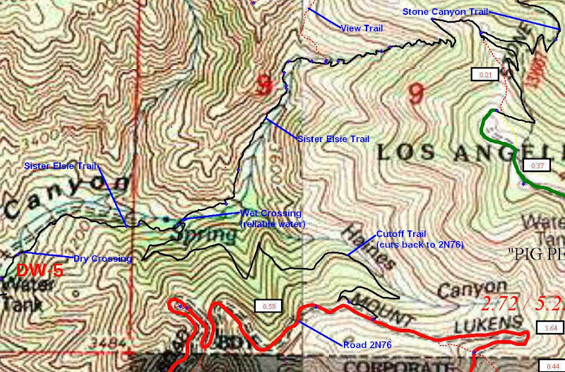
I've marked up the map that mattmaxon posted (see below). The "mystery trail" branches off the Sister Elsie Trail between the points I've marked as "Dry Crossing" and "Wet Crossing."Mike C. wrote:Could it be a new canyoneering route in the making. Hall Beckley and Sutton Canyons are nearby on the south side of Mt. Lukens....and a whole host of routes on the north side, including one aptly named Mary Jane.
I don't think it's a canyoneer's trail which is usually a minamalist trail with a few hacks to get through bad brush and yucca. This new trail took a lot of effort and follows an unusual, convoluted route. It also doesn't go toward the watercourse but rather doubles back down canyon. It's almost as though someone were trying to hide the start of the trail by placing it further up the canyon. Also, Haines Canyon is really tame in general, and the canyon is pretty wide and flat at this point. In other words, no one would be canyoneering here; it's strictly class one.
I moved into the area in 1986 and have been hiking in Haines Canyon for a long time. It's not an old trail that's been recently restored.
The more I think about it, this mystery trail does seem suspicious, although no attempt has been made to try to hide or disguise the start of the trail.
Maybe I'll walk down the mystery trail a bit on Saturday. Or maybe I'll get smart, ignore it and just keep walking.
-
Hikin_Jim
- Posts: 4688
- Joined: Thu Sep 27, 2007 9:04 pm
Well, off I go to meet HikeUp and then head up Haines Canyon to check it out ...
-
Hikin_Jim
- Posts: 4688
- Joined: Thu Sep 27, 2007 9:04 pm
And in the end it turned out to be ... a big, fat nothing (except a nice hike with HikeUp).
If you look at the map posted above, you can see that the dark blue line representing the trail ascends the canyon to the east of the old roadbed. Someone, with great effort, cut a four foot wide "trail" (no work on the tread; they just cleared the brush) from the Sister Elsie Trail to the old road bed. The trail extends about forty feet, joins the roadbed, and ... does nothing. We went down the road bed for a ways. It becomes more and more brush choked as one goes along. We crossed the creek on the roadbed very near to the point marked as "Dry Crossing" on the map, ascended the opposite stream bank, and ran into more yucca than I care to think about. So, the mystery trail remains just that, a mystery.
On the other hand, I got to introduce HikeUp to a seldom visited but very nice front country canyon with a decent trail that has year round water, even now after two years of drought. Next time you're on the Mt. Wilson Trail or Echo Mtn Trail and the hordes are getting you down, come on over to quiet Haines Canyon and have your own private hike.
-
lilbitmo
- Posts: 1092
- Joined: Tue Mar 04, 2008 9:44 pm
Hikin_Jim wrote:And in the end it turned out to be ... a big, fat nothing (except a nice hike with HikeUp).
If you look at the map posted above, you can see that the dark blue line representing the trail ascends the canyon to the east of the old roadbed. Someone, with great effort, cut a four foot wide "trail" (no work on the tread; they just cleared the brush) from the Sister Elsie Trail to the old road bed. The trail extends about forty feet, joins the roadbed, and ... does nothing. We went down the road bed for a ways. It becomes more and more brush choked as one goes along. We crossed the creek on the roadbed very near to the point marked as "Dry Crossing" on the map, ascended the opposite stream bank, and ran into more yucca than I care to think about. So, the mystery trail remains just that, a mystery.
Jim, thanks for the update.
I like the idea of less people and quiet.
On the other hand, I got to introduce HikeUp to a seldom visited but very nice front country canyon with a decent trail that has year round water, even now after two years of drought. Next time you're on the Mt. Wilson Trail or Echo Mtn Trail and the hordes are getting you down, come on over to quiet Haines Canyon and have your own private hike.
-
HikeUp
- Posts: 4097
- Joined: Thu Sep 27, 2007 9:21 pm
HJ - thanks for letting me tag along, sharing your knowledge of Haines Cyn. and tree identification (botanyfu!). Great to meet you and I look forward to future hikes.
In typical HJ acmefu fashion, here is a link to the waypoints I recorded.
A-car
B-fork in road
C-survey post (or whatever it's called): see picture below
D-on trail just past water tank
E-intersection with mystery trail
F-trail fork (wet crossing at spring)
Note-ACME uses the WGS-84 datum as does my GPS unit
Survey marker...

Intersection with mystery trail, which heads off to the left. The main trail bears to the right (hidden by HJ)...

Looking down mystery trail...

In typical HJ acmefu fashion, here is a link to the waypoints I recorded.
A-car
B-fork in road
C-survey post (or whatever it's called): see picture below
D-on trail just past water tank
E-intersection with mystery trail
F-trail fork (wet crossing at spring)
Note-ACME uses the WGS-84 datum as does my GPS unit
Survey marker...
Intersection with mystery trail, which heads off to the left. The main trail bears to the right (hidden by HJ)...
Looking down mystery trail...
-
Hikin_Jim
- Posts: 4688
- Joined: Thu Sep 27, 2007 9:04 pm
That survey marker is yet another mystery. On each of it's sides, it has a section number, 9, 10, 15, and 16. The point at which it is laid is not a four way section boundary and lies between sections 8 and 17 (not 9, 10, 15, or 16). The four way section boundary between 9, 10, 15, and 16 is quite a bit further east and is shown by "G" on this map: http://mapper.acme.com/?ll=34.26685,-11 ... centa%20CA
So if point "G" marks the four way junction of the sections, why is the marker way over to the west at point "C?" Beats me. Maybe we should rename Haines Canyon to Mystery Canyon?
-
mattmaxon
- Posts: 1137
- Joined: Mon Mar 24, 2008 12:48 pm
The photos of the mystery "trail" look like inmate hand crew practice, they'll take these crews some place and say we need a line here, do it!Hikin_Jim wrote:... why is the marker way over to the west at point "C?" Beats me. Maybe we should rename Haines Canyon to Mystery Canyon?
FWIW
Random point on a section line
I "believe" the marker(C) is a random point on a section line points "D" & "F" for some reason they both are marked "AR60"

You can see these by hiking the "Kill'em Quick Trail" Then XC toward the Camelback

-
AW~
- Posts: 2124
- Joined: Mon Oct 01, 2007 12:00 pm
Cool the mystery was solved....someone put some work into it..... 
-
Hikin_Jim
- Posts: 4688
- Joined: Thu Sep 27, 2007 9:04 pm
NOW THAT MAKES SENSE! I have seen hand crews out and about in the area (I assume) from Camp 15 (LA County Fire). The "mystery trail" took a lot of work and was done by someone who had access to all the right tools. Matt, you're a genius. Finally, a rational explanation for the "mystery trail."mattmaxon wrote:The photos of the mystery "trail" look like inmate hand crew practice, they'll take these crews some place and say we need a line here, do it!
It does appear that the aforementioned survey marker in Haines Canyon is just a random point along the section line. The thing I find curious about the concrete filled metal post is that it lists sections on each side including the R and T designations in raised metal characters. It's very specific, and someone put a lot of work into fabricating this custom survey marker. The R and T designations and the section numbers correspond to a point quite a bit further east in a different section (although on the same east-west section line). It just seems odd that someone would go to all the trouble to make this survey post with all it's highly specific markings ... and then put it in a place that doesn't correspond to its markings. I guess stranger things have happened.mattmaxon wrote:FWIWHikin_Jim wrote:... why is the marker way over to the west at point "C?" Beats me. Maybe we should rename Haines Canyon to Mystery Canyon?
Random point on a section line
I "believe" the marker(C) is a random point on a section line points "D" & "F" for some reason they both are marked "AR60"
Interesting. You really have hiked a lot around Mt. Lukens. What's the "Camelback" you're referring to? Is that the knife edged saddle between x4227 and x4275? Or?
-
mattmaxon
- Posts: 1137
- Joined: Mon Mar 24, 2008 12:48 pm
Hikin_Jim wrote: What's the "Camelback" you're referring to? Is that the knife edged saddle between x4227 and x4275? Or?
I think it is more 3600 ft & 3760 ft
This is the Google Earth KMZ for the view of Camelback
Cheers
Matt
KmlFile
1.3
http://maps.google.com/mapfiles/kml/pus ... ushpin.png
1.1
http://maps.google.com/mapfiles/kml/pus ... ushpin.png
normal
#sn_ylw-pushpin_copy1
highlight
#sh_ylw-pushpin_copy1
Camelback
-118.3014991367519
34.27643607962246
0
54.2920741394847
86.00384775648186
75.31848721553904
relativeToGround
#msn_ylw-pushpin_copy1
-118.30185112228,34.27631672767385,0
-
Hikin_Jim
- Posts: 4688
- Joined: Thu Sep 27, 2007 9:04 pm
Interesting. I'll have to give it a visual inspection this afternoon and see if I can identify it.