
It will be the subject of likely my next trip report. I don't think its an easy one, but I left the road in the image to make it easier. Bonus as always if you can tell me the trail I took the photo from earlier today.
Guess that peak
-
Nate U

- Posts: 680
- Joined: Wed Apr 05, 2023 7:38 pm
You do not have the required permissions to view the files attached to this post.
-
Sean

- Cucamonga
- Posts: 4425
- Joined: Wed Jul 27, 2011 12:32 pm
-
Elwood

- Posts: 627
- Joined: Fri Aug 15, 2008 5:23 pm
Foreground has to be Bear Divide. Point 3200 perhaps?
You do not have the required permissions to view the files attached to this post.
-
Elwood
- Posts: 627
- Joined: Fri Aug 15, 2008 5:23 pm
Topo
You do not have the required permissions to view the files attached to this post.
-
Nate U
- Posts: 680
- Joined: Wed Apr 05, 2023 7:38 pm
You are so close, yet so far!Elwood wrote: Foreground has to be Bear Divide. Point 3200 perhaps?
3270 I call "Birthday Peak" because I climbed it with my wife and our friend on her birthday this year....But alas, 3270 is not the peak in either my photo or your well-positioned google earth screenshot.
-
Elwood
- Posts: 627
- Joined: Fri Aug 15, 2008 5:23 pm
3657
You do not have the required permissions to view the files attached to this post.
-
Nate U
- Posts: 680
- Joined: Wed Apr 05, 2023 7:38 pm
Elwood wins. You can see the Clara Divide Rd cutting its way along the west flank. And Bear Divide is the best spot to do cookies and burn-outs for all the Fast and Furious types carving up The Little Tujunga Rd on weekends... (aka the posters on this forum, right?)Elwood wrote: 3657
Oh, the bonus should be pretty easy.
-
Nate U
- Posts: 680
- Joined: Wed Apr 05, 2023 7:38 pm
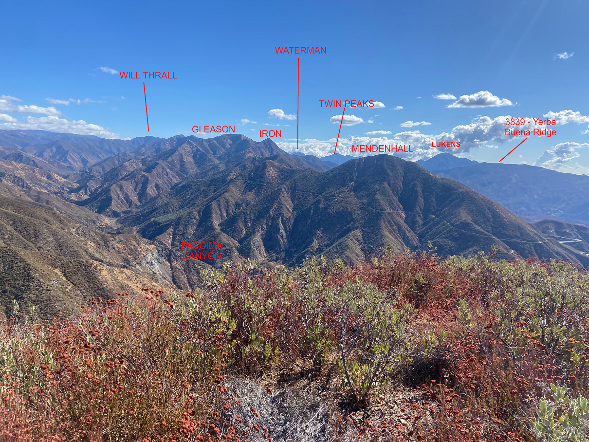
Where was I earlier today and can you name all visible peaks?
There is one familiar peak with an unfamiliar silhouette from this vantage point which threw me a little bit, but I still got 'em all.
There is one familiar peak with an unfamiliar silhouette from this vantage point which threw me a little bit, but I still got 'em all.
You do not have the required permissions to view the files attached to this post.
-
Elwood
- Posts: 627
- Joined: Fri Aug 15, 2008 5:23 pm
Not entirely sure I've got the viewpoint right, but based on Nate's recent travels:
-
Sean
- Cucamonga
- Posts: 4425
- Joined: Wed Jul 27, 2011 12:32 pm
I was just gonna say that he's on Santa Clara Divide looking across Pacoima Canyon, but Mendenhall is the flat top near the middle. I believe the fire road junction is near Highline Saddle. So that would make the closer, rounded summit The Pinnacle. If I'm correct, then way in the distance, over the left shoulder of The Pinnacle, you can also see the flat top of Markham.
-
Nate U
- Posts: 680
- Joined: Wed Apr 05, 2023 7:38 pm
You are mostly wrong I'm afraid! And missing a few, too.Elwood wrote: Wed Oct 30, 2024 7:06 am Not entirely sure I've got the viewpoint right, but based on Nate's recent travels:
You do not have the required permissions to view the files attached to this post.
-
Nate U
- Posts: 680
- Joined: Wed Apr 05, 2023 7:38 pm
You are missing a lot, but everything you say here is correct.Sean wrote: Wed Oct 30, 2024 7:28 am I was just gonna say that he's on Santa Clara Divide looking across Pacoima Canyon, but Mendenhall is the flat top near the middle. I believe the fire road junction is near Highline Saddle. So that would make the closer, rounded summit The Pinnacle. If I'm correct, then way in the distance, over the left shoulder of The Pinnacle, you can also see the flat top of Markham.
-
dima

- Posts: 1934
- Joined: Wed Feb 12, 2014 1:35 am
- Location: Los Angeles
Clearly you were on point 3650: 34.36023,-118.36489. I tell my fancy software to do this:
and I get the attached.
Code: Select all
./standalone --image /tmp/out.svg --width 2000 --radius 1500 --zfar 150000 --znear 1000 34.36023 -118.36489 $((110-30)) $((110+30))You do not have the required permissions to view the files attached to this post.
-
Nate U
- Posts: 680
- Joined: Wed Apr 05, 2023 7:38 pm
CORRECT!dima wrote: Wed Oct 30, 2024 11:25 am Clearly you were on point 3650: 34.36023,-118.36489. I tell my fancy software to do this:and I get the attached.Code: Select all
./standalone --image /tmp/out.svg --width 2000 --radius 1500 --zfar 150000 --znear 1000 34.36023 -118.36489 $((110-30)) $((110+30))
If I'm following correctly, your software generates the silhouette profile based on coordinates you feed it (wich is very cool) ....but then how did you first figure out my position? Good old-fashioned human visual recognition?
-
dima
- Posts: 1934
- Joined: Wed Feb 12, 2014 1:35 am
- Location: Los Angeles
It would take a lot more work to automate the search; doable, but work. However, it makes it really easy and fast to walk around, looking at the terrain change. So finding the spot is pretty quick.Nate U wrote: Wed Oct 30, 2024 6:52 pm If I'm following correctly, your software generates the silhouette profile based on coordinates you feed it (wich is very cool) ....but then how did you first figure out my position? Good old-fashioned human visual recognition?