
(This will be a short entry. I wasn’t even sure this odd little route deserved a trip report, but Sean said I should go for it.)
Kurt and I wrapped up our Magic Mountain hikes a few weeks ago and started to work our way east. We had to skip a big chunk east of the PCT and south of Ravenna, at least for now, due to lack of trailhead access around the Moody Truck Trail. I couldn’t figure out any way of hiking that section without backpacking, trespassing, or doing an 18 mile / 4000 foot day, which would be a bit over the line for us.
So this route, which starts where the big transmission lines cross Aliso Canyon Rd., was next one with reasonable access. The first few hundred feet of the power line road cross the edge of an undeveloped farm parcel but the area’s pretty empty, and in a few minutes you’re on public land. We began walking at about 5:30, passing an open gate just south of the highway. The only issue was a large coyote that'd run right past us, stop to stare, and then trot past us again, which became unnerving. In Thailand my wife taught me to scare off unfriendly dogs by shouting and pretending to throw rocks, so I finally tried that, and it seemed to work. (Are hikers ever attacked by coyotes?)
Near the base of the first hill, Edison Road meets 4N24. We turned left and started up. Dirt roads like this that are uninspiring by day seem much more interesting pre-dawn, when you can’t quite see the path itself and instead your senses focus on sounds, stars, lights from distant towns, and the first hints of dawn on the horizon. Since last summer we’ve done about 25 of these very early morning hikes, and it always feels magical to experience sunrise from some high place in a new area.
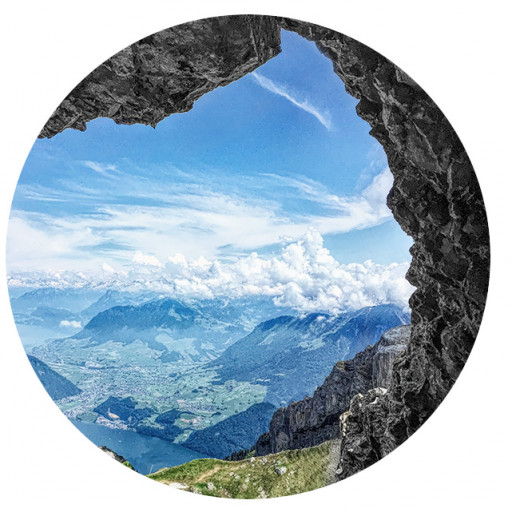
7 miles in, just before the top of the divide, we reached the PCT and turned left. 4N24 had been relatively dry but on the PCT we soon hit snow, and passed through it almost all the way to Mill Creek. Through that 6 mile section, PCT contours east along a slope. The hillside itself had little snow, but most of the trail was covered with it. I guess that unlike the hill it’s carved into, the level trail tends to collect white stuff. Very pretty but it was slippery, and every minute or so we’d find ourselves breaking through the crust and sinking down a foot or so. Except for our recent hike with Dima from Vincent Gap to the glider, I hadn’t hiked through snow for many years and Kurt never had, so we were very cautious, and therefore slow. (Good thing we’d had some practice the previous week.) Towards the end, PCT wraps around a hill to head south, intersecting with Angeles Crest and the divide road at Mill Creek Summit.
13.93 miles, 2835' of climbing: https://www.strava.com/activities/4782723068. Not a life changing experience, but the views were good, and from the north it’s probably the only reasonable way to access this section of the Angeles Forest.
Aliso Canyon to Mill Creek Summit via 4N24 and the PCT
-
David Martin
- Posts: 89
- Joined: Sun Nov 08, 2020 7:08 pm
You do not have the required permissions to view the files attached to this post.
-
jfr
- Posts: 154
- Joined: Sat Dec 12, 2009 3:01 pm
Thanks for the report! I'm planning to backpack along that PCT section soon (Mill Creek to Soledad Canyon Road) and now I know that I should wait a bit longer for the snow to melt. I know that if I wait too long it will be roasting hot, so I'm trying to find the right weather window.
My hiking trip reports: https://hikingtales.com/
-
Sean

- Cucamonga
- Posts: 4287
- Joined: Wed Jul 27, 2011 12:32 pm
Coyotes rarely attack humans, but it does happen. There's one biting people in the Bay area now.