
Bear Canyon Trail Camp - water & general conditions?
-
amrowinc

- Posts: 8
- Joined: Sun Apr 15, 2012 4:02 pm
I've been thinking about a trip to Bear Canyon coming in from Millard or the Sam Merrill trail. Does anyone have any info if there is water in creek up there?
-
Hikin_Jim

- Posts: 4688
- Joined: Thu Sep 27, 2007 9:04 pm
I might head up there on Saturday, but I haven't been recently.
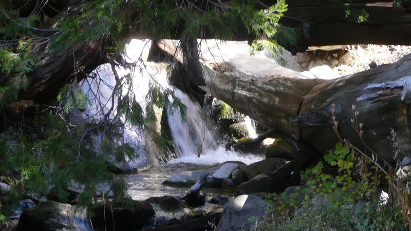
In the past, there has been water just upstream of the camp even when the creek is dry below the camp.
HJ
In the past, there has been water just upstream of the camp even when the creek is dry below the camp.
HJ
-
amrowinc
- Posts: 8
- Joined: Sun Apr 15, 2012 4:02 pm
Thanks Jim--please do let me know what you find if you do hike up there.
Don
Don
-
Hikin_Jim
- Posts: 4688
- Joined: Thu Sep 27, 2007 9:04 pm
Well, I didn't make it to Bear Canyon. I wound up in the San Gorgonio Wilderness instead. Plenty of water there.
East Fork Falls Creek:
HJ
East Fork Falls Creek:
HJ
-
amrowinc
- Posts: 8
- Joined: Sun Apr 15, 2012 4:02 pm
I guess I'll have to save up some gas money and drive over to that area. It looks like early spring conditions.
Thanks Jim
Thanks Jim
-
phstudio

- Posts: 12
- Joined: Sat Nov 03, 2012 4:05 pm
I tried to get from Millard Canyon to the Tom Sloan Saddle a couple of weeks ago. For the life of me I could not find any sign of a trail that left the canyon floor to the saddle.
Getting past Dawn Mine was quite a chore as well, as the trail was all washed out by the mine. After that, it wasn't to bad.
Getting past Dawn Mine was quite a chore as well, as the trail was all washed out by the mine. After that, it wasn't to bad.
-
amrowinc
- Posts: 8
- Joined: Sun Apr 15, 2012 4:02 pm
I did manage to get to the Bear Canyon trail camp this past weekend. Sam Merrill to Mt. Lowe one night and Lowe to Tom Sloan Saddle trail to Bear Canyon camp the next. Went out at Switzer. There was plenty of water in bear creek (not just from the rain). The trail from Tom Sloan down to the trail camp is not in the best shape resulting in some bushwacking through Poodle Dog and poison oak, resulting in me having numerous blister outbreaks. I'm never sure if it's the poison oak or poodle dog that gets me but it happens regularly.
-
Hikin_Jim
- Posts: 4688
- Joined: Thu Sep 27, 2007 9:04 pm
This thread concerns the Bear Canyon near the Arroyo Seco in the Angeles front country.
I'm not referring to the Bear Canyon by Mount Baldy.
I'm not referring to the Bear Canyon by Smith Mountain.
Nor am I referring to the 9,000,000 other freaking Bear canyons out there.
I'm considering a two day backpack. It would be a loop starting and ending at Red Box. We'd spend the night at Bear Canyon Trail Camp which is somewhere around point "P".
I have two questions:
1. Anyone been by since the fire? What kind of shape is the trail camp in?
2. Anyone been by lately? Is the creek running? Usually it is, just above the trail camp, but it generally isn't running below the camp.
HJ
-
VermillionPearlGirl
- Posts: 239
- Joined: Wed Apr 06, 2011 9:57 am
I'm sure someone will come along shortly with better information for you, the best I have is an unplanned meander before work one day about two or three months ago. I left from Switzer and went about as far as your R, maybe close to your Q. So I didn't make it all the way to the camp. I found the trail itself to be of the outdoorsy fun variety, some fallen to trees to navigate, that kind of thing. I had actually never been in Bear Canyon and I'm surprised I haven't gone back yet because I really liked it!
So like two or three months ago, which is not at all recent, there was plenty of water in that area. I was shocked actually because literally everywhere else I had been, like Rubio for instance, was so dry or stagnant already.
Hopefully someone has better information But I'm definitely interested in hearing your report!
So like two or three months ago, which is not at all recent, there was plenty of water in that area. I was shocked actually because literally everywhere else I had been, like Rubio for instance, was so dry or stagnant already.
Hopefully someone has better information
-
Uncle Rico

- Posts: 1484
- Joined: Thu Mar 20, 2008 7:48 pm
That looks like a cool trip Jimbo. Post pics when you get back.
-
cougarmagic

- Posts: 1411
- Joined: Wed May 07, 2008 5:21 pm
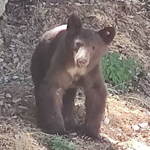
I haven't been there in about three years. Post-fire, lots of dirt had come down on the camp, burying a couple of picnic tables inot picnic-platforms. But there was still flat space for camping. The trail was not good. Half stream walking, and half finding bits of trail but climbing over trees. Lots of bear poop.
Since the loss of Richard Nyerges, I don't know if any maintenance has been done.
Anyhow, can I come on your trip??
Since the loss of Richard Nyerges, I don't know if any maintenance has been done.
Anyhow, can I come on your trip??
-
Hikin_Jim
- Posts: 4688
- Joined: Thu Sep 27, 2007 9:04 pm
Haven't scheduled it yet, but tentatively one of the weekends next month.Uncle Rico wrote: That looks like a cool trip Jimbo. Post pics when you get back.
HJ
-
Hikin_Jim
- Posts: 4688
- Joined: Thu Sep 27, 2007 9:04 pm
A couple of friends of mine went through there a week or two ago. They didn't remark about bad trail conditions, so I think it's OK there.cougarmagic wrote: I haven't been there in about three years. Post-fire, lots of dirt had come down on the camp, burying a couple of picnic tables inot picnic-platforms. But there was still flat space for camping. The trail was not good. Half stream walking, and half finding bits of trail but climbing over trees. Lots of bear poop.
Since the loss of Richard Nyerges, I don't know if any maintenance has been done.
As for camping, give me a flat spot, and I'm good. Don't need no stinkin' picnic tables! (Well, I do usually use them if they're there)
Of course! But let me schedule it first.
HJ

-
Hikin_Jim
- Posts: 4688
- Joined: Thu Sep 27, 2007 9:04 pm
Still working on the scheduling. We're now moving at the end of the month, so probably on hold for now. 
HJ
HJ
-
turtle

- Posts: 152
- Joined: Wed Jan 27, 2010 11:35 am
I passed through Bear Canyon on 2014-03-03. The camp is in very good shape, with several good clean and flat spots for a tent, several picnic tables, and several fire-stoves.Hikin_Jim wrote: 1. Anyone been by since the fire? What kind of shape is the trail camp in?
I passed through immediately after the large rainfall, so there was quite a bit of flow along the entire length of Bear Canyon. It was quite turbid, though, perhaps too turbid to be potable. My guess is that the turbidity will subside relatively soon, long before the flow dries out entirely.Hikin_Jim wrote: 2. Anyone been by lately? Is the creek running? Usually it is, just above the trail camp, but it generally isn't running below the camp.
-
AnthonyEKing
- Posts: 24
- Joined: Mon Mar 25, 2019 3:45 pm
Question: Water Conditions @ Bear Canyon Trail Camp, Extra Credit Quest Inside
Hi all. Curious if anyone has been to the camp in the last week or so and can tell me if the stream is running at all.
Also, extra question - has anyone taken the Tom Sloan Trail from Mount Lowe Trail Camp to the saddle and then the trail down to Bear Canyon? I was there (Bear Canyon Trail Camp) early this year and there was a huge landslide of trees blocking the trail just east of the camp towards the Tom Sloan Saddle. I'm also curious of the Tom Sloan Trail condition between Mount Lowe & the saddle, too.
Any info would be appreciated! Thanks!
You do not have the required permissions to view the files attached to this post.
-
Sean

- Cucamonga
- Posts: 4289
- Joined: Wed Jul 27, 2011 12:32 pm
I don't think trail workers have had access to those trails since the pandemic. So you will probably encounter obstacles. But the trailbeds should be good.
-
Girl Hiker

- Posts: 1458
- Joined: Fri Apr 04, 2014 7:46 am
I hiked the Tom Sloan Trail. Yes, there were a couple of knocked down trees but the crew RLC recently cut one of them down. The trail on Bear Canyon is nice. It's just a bit overgrown but you can hike the trail with no issues. Personally, The route that I prefer to hike from is starting at Eaton Saddle then down Bear Cyn to Tom Sloan Canyon then to Mt. Lowe Trail Camp via the short cut trail that Sean helped build. From there you can go anywhere you want.