
USFS asked for some volunteers to clear trails around Chantry Flat (mainly for cabin owners in Big Santa Anita, I think), so I got to go into the burn area there yesterday (10/15) and took a few pics. All in all, many places seemed to make it through fairly well—everyone was pretty happy to see how much didn't burn. I went up to Spruce Grove camp and turned back, but a different group went as far as Sturtevant Camp (apparently only lost one cabin, everything else survived).
Chantry itself was totally fine, amazingly. All the buildings and the picnic area seemed ok, from what I saw:
You can see the fire came right up to the parking lot:
There were lines of phos-chek on the road leading down into the canyon as well. I didn't take photos of the cabins—a handful, but less than half, burned. (Lots of cabin owners were there volunteering.) Here's the top of Sturtevant Falls:
Above the falls, some stretches seemed mostly fine, save for a covering of ash that hasn't washed away yet:
Some new stuff coming up already, little eucalyptuses I think:
Lots of ash and soot everywhere, often in seemingly random patches where an ember must have landed or something.
The trails were in surprisingly good shape for the most part—granted, it hasn't rained yet, which will be the real test. Still, it seemed like we only passed a half-dozen or so spots that would definitely wash out, and not many trees had fallen yet. (Most of the trail work was just digging little trenches through the mini-slides of rock and ash on the cliffside sections, so definitely only good until the next rain. Fire crews had already chainsawed a few trees.)
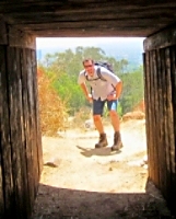
Spruce Grove trail camp was pretty much untouched:
Tapatalk is telling me I've gotta go VIP to upload more photos, so I'm going to reply to this post instead...
Chantry Flat area, trail work, 10/15
-
patrick

- Posts: 33
- Joined: Sat Aug 15, 2020 5:24 pm
You do not have the required permissions to view the files attached to this post.
-
patrick
- Posts: 33
- Joined: Sat Aug 15, 2020 5:24 pm
Above Spruce Grove we saw some smoke, and maybe 100ft above the camp we found this smoldering hole with some flaming embers:
We broke them up and shoveled some dirt on it, and reported... sort of crazy to see right next to an area that was basically untouched. Some bear scat was a good sign:
From higher up (these are on the way back, via the horse trail above the falls), you could see that lower in the valley was generally much better off. Here, below Mt. Zion looking east, you can clearly see a road cutout that I had never noticed before. I couldn't find it on any of the maps I could dig up, but one of the other guys said he thought it went down and connected behind the cabins at the canyon floor:
Here's a photo from June, from about the same spot:
Some manzanitas:
Some stretches got really toasted, and there didn't seem to be much rhyme or reason to what burned.
Even in really burned areas, the trail has held up well so far... I'm curious how well stretches like this, which are totally fine now, will hold up through the rainy season:
Have a few more, one more reply coming...
You do not have the required permissions to view the files attached to this post.
-
patrick
- Posts: 33
- Joined: Sat Aug 15, 2020 5:24 pm
Few more pics here. You can really see how the fire kinda skipped over the bottom of the valley:
Will be interesting to see more of the interior of the fire area... from what I could see, which was only into a few canyons, there were definitely some slopes with a lot of trees left.
Random piles of ash were very strange. The whole forest still smelled very strongly, by the end of the day I smelled like a campfire.
Lots of trees were burned at the base, and the interior had kind of burned out... does this kill a tree? This kind of thing was very common:
Burned manzanitas:
Back down into Chantry:
Photo from nearby, from June:
You do not have the required permissions to view the files attached to this post.
-
walker

- Posts: 248
- Joined: Mon Apr 08, 2013 11:14 pm
Hey Patrick, thanks for sharing those images.
Great to hear that it's not a total loss of the cabins. Glad that Sturdevant maybe pulled through. I'm curious to see if Fern Lodge made it.
It seems like the canyon bottoms are usually protected to some degree by the moisture and the fire jumps across to the opposite side above the canopy. Like you said, the real test is going to be to see to what degree all of those naked slopes up above start to drop tons of debris down into the canyon once winter weather comes.
I think the road cut is Burma road, built in the '60s for the construction of the check dams. It's been really overgrown for a long time, maybe now's the time it could be rehabilitated as a hiking trail.
Some interesting history on the check dam projects here:
https://canyoncartography.com/2018/01/2 ... ion-years/
-
Sean

- Cucamonga
- Posts: 4289
- Joined: Wed Jul 27, 2011 12:32 pm
Thanks for the report. I'm glad to hear many of the cabins survived. I've seen lots of trees with bad burn scars along the trunk. I think they can survive as long as some of the interior bits remain intact and can pump water up to the branches and leaves.
-
patrick
- Posts: 33
- Joined: Sat Aug 15, 2020 5:24 pm
Ah yes, the guy did say Burma, I couldn't remember. Map I found through that link lines up exactly. Definitely not overgrown now! We went by where it terminated on the Gabrieleno, just past Cascade picnic area... easy to access now, and very visible.walker wrote: I think the road cut is Burma road, built in the '60s for the construction of the check dams. It's been really overgrown for a long time, maybe now's the time it could be rehabilitated as a hiking trail.
thanks for the link!
-
Girl Hiker

- Posts: 1458
- Joined: Fri Apr 04, 2014 7:46 am
Thanks for posting these great pictures. Although its devastating to look at it gives those of us an idea of how much damage the fire caused. I would love to volunteer but I heard from the RLC as you mentioned it was mostly cabin owners to volunteer. Thanks for the report.
-
EnriqueFreeque
- Posts: 13
- Joined: Fri Aug 12, 2016 7:51 pm
So happy to hear that Sturtevant Camp likely survived mostly intact, and ditto re.: so many of the cabins. That Camp is living history, a true treasure from simpler rustic times that I hope can somehow survive forever.
It's interesting to see what the burn exposed; namely the old Burma Road. On a solo hike through Sturtevants years ago, early '90s, a camp caretaker told me about a time he bushwhacked up the old service road he said once accessed the camp; there was indeed a time, he said, in response to my obvious incredulity, that it was possible to drive the old service road up to Sturtevants.
Just curious if the Burma Road is the same road he was talking about, that accesses the Camp? And wondering if some of you have also bushwhacked it...
-
Slowest_Hiker
- Posts: 272
- Joined: Sun Jul 31, 2011 12:31 pm
Thank you for posting. During the fire, I was haunted by the mental image of the Spruce Grove sign (and everything else) on fire.
I'll be interested to know which cabins were unfortunately lost. And what happened on the other side of the Zion loop. I looked for the beginning of the Burma road a few years ago and never found it.
I'll be interested to know which cabins were unfortunately lost. And what happened on the other side of the Zion loop. I looked for the beginning of the Burma road a few years ago and never found it.
-
sunset.jim
- Posts: 1
- Joined: Mon Oct 19, 2020 1:55 pm
Hi Patrick. It was good working and hiking with you. I hope you will join us on some RLC work when they lets us back out there.
Yes, that was the Burma Road. Interesting history that was posted about it. I knew it was built for the check dam work but didn’t realize it went past Cascade at one time.
Yes, that was the Burma Road. Interesting history that was posted about it. I knew it was built for the check dam work but didn’t realize it went past Cascade at one time.
-
patrick
- Posts: 33
- Joined: Sat Aug 15, 2020 5:24 pm
Hey Jim! Yes, I emailed Brenda, will see you out there again when things open back up.
-
ReFreshing

- Posts: 68
- Joined: Mon Nov 26, 2018 1:00 pm
Thanks for the updates. Glad to hear it isn't as bad in the canyon bottom. Sturtevant Camp confirmed to be intact.