
Where is everyone?
-
HikeUp

- Posts: 4100
- Joined: Thu Sep 27, 2007 9:21 pm
Did the virus stop everyone from hiking and posting TR's?
-
Matthew

- Supercaff
- Posts: 638
- Joined: Mon Nov 30, 2015 8:25 am
- Location: Pasadena
nope! Dima and I put a robot in a mine last weekend!
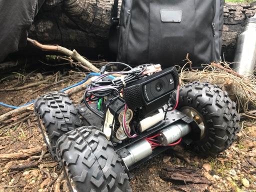
stoke is high
-
David R
- OG of the SG
- Posts: 687
- Joined: Sun Jun 12, 2011 10:28 pm
I've been hiking nothing too exciting. Last Sunday was Lukens from Duekmajian Park as a loop. Did it in under three hours which was a nice time. I think most people are in bed with COVID-19 so we need to let them recuperate.
-
HikeUp
- Posts: 4100
- Joined: Thu Sep 27, 2007 9:21 pm
Clockwise or counterclockwise?David R wrote: I've been hiking nothing too exciting. Last Sunday was Lukens from Duekmajian Park as a loop. Did it in under three hours which was a nice time. I think most people are in bed with COVID-19 so we need to let them recuperate.
-
Tom Kenney

- Posts: 386
- Joined: Sat Sep 29, 2007 7:51 pm
BORING: I've been doing laps on Rim Tr/Rincon Rd to chew at the deadfall. There is another phantom out there with a slightly bigger saw than mine, but the really big stuff remains.
INTERESTING: I met a guy out on the trail, echoes from the past, acquaintance-of-an-acquaintaince sort of thing (though I think I've met him 20+ yrs ago). He's been restoring an old trail that is an older alignment of a current trail. Someone in our group of riders 20 years ago had mentioned this project, and at the time I thought "Hey, that's neat...Not likely to go there myself, but..." After a few years, and some more casual mentions of this trail, I decided to check Goggle Earth. There was a good long section of trail that petered out into the fir forest, discouragingly far from anything but steep mountainside. I revisited the area on GE over the years, and it steadily grew towards an intriguing destination. The old trailbed is probably of CCC construction, looks very standard and similar to many other San Gabriel trails. There are a few places in the San Gabriels where I'd like to see old trails recovered or new trails built, and this scratches that itch.
INTERESTING: I met a guy out on the trail, echoes from the past, acquaintance-of-an-acquaintaince sort of thing (though I think I've met him 20+ yrs ago). He's been restoring an old trail that is an older alignment of a current trail. Someone in our group of riders 20 years ago had mentioned this project, and at the time I thought "Hey, that's neat...Not likely to go there myself, but..." After a few years, and some more casual mentions of this trail, I decided to check Goggle Earth. There was a good long section of trail that petered out into the fir forest, discouragingly far from anything but steep mountainside. I revisited the area on GE over the years, and it steadily grew towards an intriguing destination. The old trailbed is probably of CCC construction, looks very standard and similar to many other San Gabriel trails. There are a few places in the San Gabriels where I'd like to see old trails recovered or new trails built, and this scratches that itch.
-
dima

- Posts: 1934
- Joined: Wed Feb 12, 2014 1:35 am
- Location: Los Angeles
So is this rebuilt trail finished? Is it secret?
-
Tom Kenney
- Posts: 386
- Joined: Sat Sep 29, 2007 7:51 pm
I only had a short convo with Person X. He did mention that he welcomes traffic to help burn it in, but also seemed reluctant to publicize, especially on bike forums. It's not finished yet, with maybe 2 years' work to go unless some more help arrives. It's not really secret, but I want to do a bit of snooping before I say. So far, all I've got is Person X's story, years of uninterrupted progress visible on GE, and no obvious attempt to conceal any of the work.dima wrote: So is this rebuilt trail finished? Is it secret?
I'm very excited! This trail, when complete, will make access to 2 'backcountry' campgrounds and a high summit easier and more interesting.
Astute observers here may have already guessed it's location!
-
Girl Hiker

- Posts: 1469
- Joined: Fri Apr 04, 2014 7:46 am
-
dima
- Posts: 1934
- Joined: Wed Feb 12, 2014 1:35 am
- Location: Los Angeles
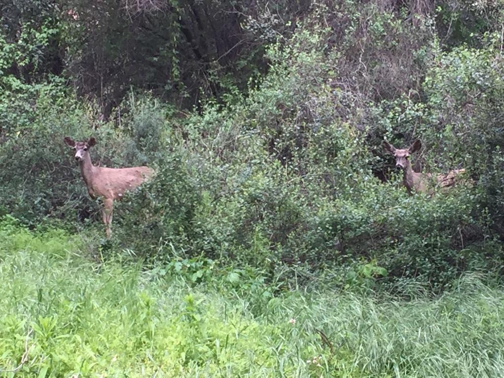
Yesterday I went up the Lone Tree to Muir Peak, and back via Middle Merrill. The Lone Tree trail is in good condition, and West Fuji has a new register, placed by the Girl Hiker. Trail down to Rubio from the tower on Lower Merrill is in good shape too. Very few people around, even on Lower Merrill, so get out there. Low chances of virus transmission I think.
-
Girl Hiker
- Posts: 1469
- Joined: Fri Apr 04, 2014 7:46 am
-
Matthew
- Supercaff
- Posts: 638
- Joined: Mon Nov 30, 2015 8:25 am
- Location: Pasadena
Yesterday I climbed part of Muir peak to the water tank to take a nap and gaze over the city. The ridge is quite overgrown but very very pretty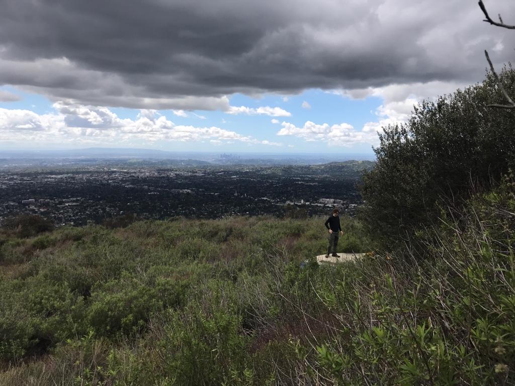
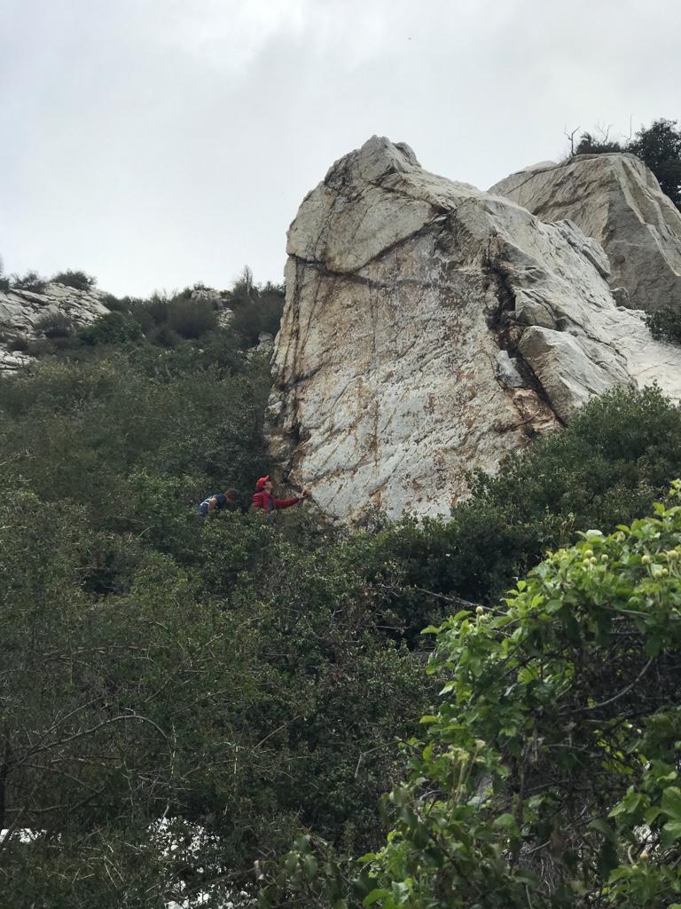
Then later in the day, I did some bouldering by Crystal lake. Road was quite open with the occasional racer zooming past.
Then later in the day, I did some bouldering by Crystal lake. Road was quite open with the occasional racer zooming past.
stoke is high
-
David R
- OG of the SG
- Posts: 687
- Joined: Sun Jun 12, 2011 10:28 pm
I went to Monticito Peak on Sunday, second time up there nice scramble at the end.
You do not have the required permissions to view the files attached to this post.
-
JeffH

- Posts: 1399
- Joined: Sun Nov 28, 2010 7:09 am
I’m staying close to home on the trails less traveled.
"Argue for your limitations and sure enough they're yours".
Donald Shimoda
Donald Shimoda
-
dima
- Posts: 1934
- Joined: Wed Feb 12, 2014 1:35 am
- Location: Los Angeles
It's really clear out, right? The rain and the lack of traffic is magic for air quality. Could clearly see Catalina, San Clemente and Santa Barbara islands from West Fuji. The view from Montecito peak looks pretty majestic too.
-
JeffH
- Posts: 1399
- Joined: Sun Nov 28, 2010 7:09 am
The Wilderness Park is closed, as is the paved Thompson Creek trail leading to it. I read today we are also closing access to Potato Mountain, which is technically in the Park.Girl Hiker wrote:Jeff, is that Claremont loop? I was thinking of going is it still open?
"Argue for your limitations and sure enough they're yours".
Donald Shimoda
Donald Shimoda
-
JeffH
- Posts: 1399
- Joined: Sun Nov 28, 2010 7:09 am
It’s a great time right now, except for the fact that we shouldn’t be doing it.dima wrote:It's really clear out, right? The rain and the lack of traffic is magic for air quality. Could clearly see Catalina, San Clemente and Santa Barbara islands from West Fuji. The view from Montecito peak looks pretty majestic too.
I have noticed that the rain-heat-rain-heat cycles have been very very good for the poison oak.
"Argue for your limitations and sure enough they're yours".
Donald Shimoda
Donald Shimoda
-
dima
- Posts: 1934
- Joined: Wed Feb 12, 2014 1:35 am
- Location: Los Angeles
All official guidance I've seen says that it's fine to go out, as long as you don't do it with dozens of other humans. They all are (were?) at Runyon and Griffith, so I'm feeling ok about going out.
-
David R
- OG of the SG
- Posts: 687
- Joined: Sun Jun 12, 2011 10:28 pm
The recommendation is to get out and exercise, it's the numbnuts who think its a social event that have ruined it for others. I was planning on hiking closer by but I knew it would be overrun by the filthy casuals and purposely went to a TH that I knew would be infrequently used. We met two groups and some bikers for the entire duration.
-
Uncle Rico

- Posts: 1484
- Joined: Thu Mar 20, 2008 7:48 pm
Ha! Relieved to know I'm not the only one yelling at kids to get off my lawn.David R wrote: The recommendation is to get out and exercise, it's the numbnuts who think its a social event that have ruined it for others. I was planning on hiking closer by but I knew it would be overrun by the filthy casuals and purposely went to a TH that I knew would be infrequently used.
I've been staying local recently - nothing TR worthy. Not necessarily on account of the whole stay at home thing, but mostly because I'm kinda burned out on driving so much. Now I'm getting kinda burned out on going local. There's apparently no pleasing me. LOL
-
AW~

- Posts: 2125
- Joined: Mon Oct 01, 2007 12:00 pm
On my beach trip last summer(in my dreams because they supposedly dont exist lol), the first day I encountered 1 or 2 people at the first day beaches. Both of them beaches are supposed to have nobody.... so they ruined it. Or did I ruin it? Or did I ruin it because they were there first? At the end of the day, we managed to settle it without confronting or even talking to each other. Some would say it was civilized common sense.David R wrote: The recommendation is to get out and exercise, it's the numbnuts who think its a social event that have ruined it for others. I was planning on hiking closer by but I knew it would be overrun by the filthy casuals and purposely went to a TH that I knew would be infrequently used. We met two groups and some bikers for the entire duration.
To me, its the govt central planning that ruins everything....as usual. And their supporting judgers...aka utopians/nanny staters.
The Runyon thing is more fake news, thats all it is....and yes I think all the utopian plans are nightmares.
Ive went 'hikining' the govt approved way lol...didnt see nary a soul. Super quiet...
https://www.parks.ca.gov/GoogleTrekker
-
dima
- Posts: 1934
- Joined: Wed Feb 12, 2014 1:35 am
- Location: Los Angeles
I don't think the govt cares if you go to Runyon or not. For any definition of "govt"
-
wesweswes
- Posts: 122
- Joined: Tue Feb 12, 2019 10:59 pm
- Location: Venice beach
I've been finding the trails a little further out have way fewer people, which is ultimately more congruent w/ social distancing, even if there's a bit of a drive.
-
Taco

- Snownado survivor
- Posts: 6218
- Joined: Thu Sep 27, 2007 4:35 pm
Jeko, where is that rock? Near Soldier Creek?
Tom, my buddy Luis is a USFS volunteer 4x4 guy. I ride Rincon with him sometimes. He has cut and pulled a buncha stuff off the road, on the eastern half. We encountered a lot of deadfall more towards Redbox recently.
Tom, my buddy Luis is a USFS volunteer 4x4 guy. I ride Rincon with him sometimes. He has cut and pulled a buncha stuff off the road, on the eastern half. We encountered a lot of deadfall more towards Redbox recently.
-
Taco
- Snownado survivor
- Posts: 6218
- Joined: Thu Sep 27, 2007 4:35 pm
I’ve lost track of time, but a lil while ago I rode up Monrovia Cyn to White Saddle, then down to the summit of Mt Bliss, then down into Duarte on Fish Canyon road, where the shooting range I was taught/trained at as a kid was before the new housing development people complained about or range which had been there for a long time. We need more urbanization and housing developments, not training for responsibility and self reliance as well as self defense. Anyway I’m disappointed with the direction the hive is flying in. I’ll stop talking for a while.
-
David R
- OG of the SG
- Posts: 687
- Joined: Sun Jun 12, 2011 10:28 pm
Did the Rubio Canyon drainage loop on Sunday went up the incline trail to Echo Mountain that was empty due to Cobb Estate trail being closed even though some parties defied the order. The trail is in decent shape, a couple of places that are eroded immediately after the rock clamber and as you contour off the incline. Took Sam Merrill up to the ridge and climbed along that to true Inspiration Point, descended to Pavilion and met another group of hikers with dogs. Zipped up to Muir and descended to West Fuji which while unpleasant wasn't too bad. Erosion in couple of spots as you contour around West Fuji on the way down. Trail has also gotten pretty bushy with lots of ducking to avoid getting your head chopped off. Great day out with minimal amount of hikers due to closures.
-
davidwiese

- Posts: 92
- Joined: Mon Jul 30, 2018 4:00 pm
Wife and I parked one car at the bottom of Lone Tree Trail and took another to Chantry Flat a few weeks ago. Took Upper Winter Creek to Wilson saddle, then hiked down to Idlehour and spent the night. Lovely spot, flow in Eaton Wash was strong. One other couple was there that night.
Next morning we hiked up Eaton Wash on the Idlehour Trail to Inspiration Point. Had lunch there, and then went over and bagged Mt. Zion before descending down the lovely and seldom-used Lone Tree Trail near our car. That ridge is a beast, I don't envy those going up!
Map here https://caltopo.com/m/AN9E (we skipped Harvard/Yale -- I got to the NO TRESPASSING fence and didn't feel like easily circumventing it until I went home and read up on it a bit more -- looks like a ton of people do it?)
You do not have the required permissions to view the files attached to this post.
-
davidwiese
- Posts: 92
- Joined: Mon Jul 30, 2018 4:00 pm
Last Thursday we parked at the Mill Creek Summit Picnic Area and hiked up to the Triple Divide. It was a very cool day (41 deg where we parked) and the snowline wasn't far up trail. We took the road up and the PCT down -- ended up being about ~12 miles all said and done. I was post-holing above my ankles on the Divide summit area. Storms started to roll in later in the afternoon and we started getting a bit of fresh snow fall on us as we neared the car.
Map here https://caltopo.com/m/H0BP
(we didn't go all the way out to Pacifico, conditions were much snowier than anticipated -- we explored a bit around the Divide before taking an overgrown PCT alternate back to the official PCT on the north and wrapping back down to the car)
Map here https://caltopo.com/m/H0BP
(we didn't go all the way out to Pacifico, conditions were much snowier than anticipated -- we explored a bit around the Divide before taking an overgrown PCT alternate back to the official PCT on the north and wrapping back down to the car)
You do not have the required permissions to view the files attached to this post.