
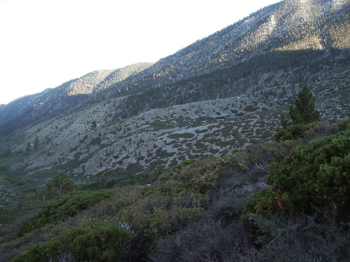
I did a little backpack in the San Gorgonio Wilderness 9/10 - 9/12/2008 from the Fish Creek Trailhead to Big Tree Camp with a little exploratory side trip down the N Fork of theWhitewater River past Big Tree Camp. I climbed Grinnell Mtn on the way in and Lake Peak on the way out. Great weather, great scenery, great hiking!
Photos: http://picasaweb.google.com/jim.barbour ... #slideshow
San Gorgonio: Fish Cr to Big Tree Camp + Lake & Grinnell
-
simonov

- Posts: 1108
- Joined: Tue Nov 27, 2007 5:44 pm
- Location: Reno, NV
Great photos and captions, as usual. You're the next John Robinson.
I have never heard of "Zahniser-Lake Saddle" until now. For a while I was thinking maybe it's a new name for Fish Creek Saddle, but I gather it's a name for the saddle between Fish Creek Saddle and Mineshaft Saddle?
Edit: I know where it is, with that sign. It's near where this photo was taken:
I have never heard of "Zahniser-Lake Saddle" until now. For a while I was thinking maybe it's a new name for Fish Creek Saddle, but I gather it's a name for the saddle between Fish Creek Saddle and Mineshaft Saddle?
Edit: I know where it is, with that sign. It's near where this photo was taken:
Nunc est bibendum

-
Hikin_Jim

- Posts: 4688
- Joined: Thu Sep 27, 2007 9:04 pm
Wow. High praise indeed. I thank you. In a way, I wish a great lover of the mountains would take over the legacy of Mr. Robinson. I don't know the two gentlemen who have taken over Robinson's classic trail guides, but I don't get the sense of deep passion from them that is clear in Robinson's writings. The guides could use some serious updating; updating beyond merely inserting "Adventure pass required to park" in Robinson's existing verbiage.simonov wrote: Great photos and captions, as usual. You're the next John Robinson.
Exactly, that's the one. I think it's actually an important distinction since not one but two trails depart from the main trail at Zahniser-Lake Saddle. The old trail that goes directly from Dry Lake to Zahniser-Lake Saddle is actually a much better route for those camping near Lodgepole who then want to go on to the summit, although perhaps that's why this route was abandoned: it makes the summit overly accessible. In Robinson's mid 80's version of Trails of the San Bernardinos, the old direct route is the route he recommends. He doesn't even mention that I recall the now standard route through Trail Flats.simonov wrote: I have never heard of "Zahniser-Lake Saddle" until now. For a while I was thinking maybe it's a new name for Fish Creek Saddle, but I gather it's a name for the saddle between Fish Creek Saddle and Mineshaft Saddle?
Cool photo by the way.
-
Hikin_Jim
- Posts: 4688
- Joined: Thu Sep 27, 2007 9:04 pm
Yes, moraines. The canyon of the N Fork of the Whitewater has that unmistakeable "U" shape that has "glacier" written all over it. Not only are there moraines but also what appear to be glacial "erratics," relatively large, solo rocks deposited seemingly at random in otherwise scoured places. The largish white rock I point out as a landmark appears to be one such glacial erratic.406 wrote:^^^^Moraines? Really?
The SGW has a lot of glacial influence. Both Dry and Dollar Lakes were formed by glacial action. Dollar lake is in a classic glacially carved bowl. If you've ever looked at the chaotic contour lines of the terrain between Dry and Dollar Lakes and wondered why they're like that, now you know: glaciers. Glaciers repeatedly scoured and piled up moraines on the N face of San G even in the small "mini" ice ages of the relatively recent (geologically speaking) past.
And, yes, it really is a cool spot. Talk about getting away from it all. There's, what, 20 million people in the 5 county greater LA area? We saw not one soul the whole time once we left the trailhead. Once in the N Fork drainage, we saw not even so much as a foot print. Got solitude?
-
lilbitmo

- Posts: 1092
- Joined: Tue Mar 04, 2008 9:44 pm
Jim, it's a pleasure to see someone post a complete and accurate account of their outdoor adventure. The pictures are great and the captions allowed me to follow along, all in all a great TR.
The other thing you could mention about the person who removed the sign is that it could be that someone's loved one who gets lost in the wilderness oneday and that very sign may be the one that saves their life? Who knows. Signs for the purest are a pain in the butt but for someone less familiar with the area it gives the illusion of being close to mankind and for some that is enough to keep them going - emotionally and mentally. Thanks for putting that sign back up - you are right it is our heritage - and everyone knows that you should leave no trace - tearing down signs only proves that that person sees themselves as "Unique" and the rules don't apply.
Hope to see you on the trail soon.
Thanks
-
Rumpled
- Posts: 271
- Joined: Mon Feb 25, 2008 10:57 pm
Pretty cool writeup; and timely for me.
I'm hoping to try and knock off San G soon - maybe mid Oct?
I was thinking of going up Fish Creek. Due to the kid's soccer; I wouldn't be able to hit the trail until probably noon to 2pm.
I'm hoping I can find a camp about 3-5 miles in; overnight, then summit and return to TH without killing myself. (I'm slow)
Anybody got suggestions? I don't yet have good beta on camps, trail junctions and distances - time to buy a new map and/or book!
-
Hikin_Jim
- Posts: 4688
- Joined: Thu Sep 27, 2007 9:04 pm
As far as a book and/or map are concerned:Rumpled wrote:Pretty cool writeup; and timely for me.
I'm hoping to try and knock off San G soon - maybe mid Oct?
I was thinking of going up Fish Creek. Due to the kid's soccer; I wouldn't be able to hit the trail until probably noon to 2pm.
I'm hoping I can find a camp about 3-5 miles in; overnight, then summit and return to TH without killing myself. (I'm slow)
Anybody got suggestions? I don't yet have good beta on camps, trail junctions and distances - time to buy a new map and/or book!
1. Get John Robinson's book, Trails of the San Bernardinos. It's a bit dated, but Robinson is still the best source of 411 for the area.
2. Get the San Gorgonio Wilderness map from Tom Harrison Maps. It's the most up to date map I'm aware of. It marks all the mileages and trail camps.
For the specifics you mention, you might try staying at Fish Creek Saddle Camp (see my TR). There's no water at the saddle itself, but if you come in from the east there is water available at Fish Creek and then again at a stream crossing just before the major switchbacks that climb to the saddle. Also, there's water at Lodgepole Spring which is 1 mile west of the saddle. Do be aware that the road to the Fish Creek trailhead is a dirt road. I got my Honda Accord up and down it w/o a problem, but you have to take it slow. I think it took me about 45 minutes to an hour to drive from Hwy 38 to the trailhead. It would be important to factor that extra drive time in to your plans.
I think you'll like the Fish Creek Trailhead. It's a pretty area. It's also a much higher trailhead, and in my opinion the easiest route to the summit.
HJ
-
Rob
- Posts: 158
- Joined: Thu Sep 27, 2007 9:26 pm
Or park at Aspen Grove TH then hike up a few hundred feet to join Fish Creek TH. You drive past Aspen Grove TH to reach Fish Creek TH.Hikin_Jim wrote:Do be aware that the road to the Fish Creek trailhead is a dirt road. I got my Honda Accord up and down it w/o a problem, but you have to take it slow. I think it took me about 45 minutes to an hour to drive from Hwy 38 to the trailhead. It would be important to factor that extra drive time in to your plans.
-
Hikin_Jim
- Posts: 4688
- Joined: Thu Sep 27, 2007 9:04 pm
Why thank you. I tried to make it something that could get someone to the spot if they followed along. I hope it's helpful to someone and that it sparks interest in more of the SGW than Vivian Creek and a few other heavily used spots.lilbitmo wrote:Jim, it's a pleasure to see someone post a complete and accurate account of their outdoor adventure. The pictures are great and the captions allowed me to follow along, all in all a great TR.
That actually crossed my mind too. When distinctive land marks start getting torn down, people can wind up getting lost, and as you point out, when discouraged people pass a sign of civilization, it can be very helpful to them psychologically.lilbitmo wrote:The other thing you could mention about the person who removed the sign is that it could be that someone's loved one who gets lost in the wilderness oneday and that very sign may be the one that saves their life? Who knows. Signs for the purest are a pain in the butt but for someone less familiar with the area it gives the illusion of being close to mankind and for some that is enough to keep them going - emotionally and mentally.
Also, this trail sign might be a bit more important than most. The trail heading back to the trailhead from Fish Creek Saddle is indistinct. Particularly if one were relatively new to hiking, the return from FC Saddle could be problematic. "Is this really the trail? Which way does the trail go? Why is this track heading NNE; isn't the trailhead east? Am I lost!?!" If one sees a trail sign, particularly a prominently located one like the one at FC Saddle, then one is reassured. "Oh, thank God! Here's a trails sign. I am on the trail."
Hope so too. Hike on!lilbitmo wrote:Thanks for putting that sign back up - you are right it is our heritage - and everyone knows that you should leave no trace - tearing down signs only proves that that person sees themselves as "Unique" and the rules don't apply.
Hope to see you on the trail soon.
-
Hikin_Jim
- Posts: 4688
- Joined: Thu Sep 27, 2007 9:04 pm
Good suggestion, Rob. Yes, the Aspen Grove TH saves you a lot of driving for only a minimal amount of addtional elevation gain. I guess it adds 4 (6?) miles RT to your hike, but it's a really nice section of the SGW. If you came in from Aspen Grove, you could camp at Fish Creek Camp instead of Fish Creek Saddle. Fish Creek Camp has water about .25 to .5 miles up the trail. The water is flowing slowly right now, but it is flowing.Rob wrote:Or park at Aspen Grove TH then hike up a few hundred feet to join Fish Creek TH. You drive past Aspen Grove TH to reach Fish Creek TH.Hikin_Jim wrote:Do be aware that the road to the Fish Creek trailhead is a dirt road. I got my Honda Accord up and down it w/o a problem, but you have to take it slow. I think it took me about 45 minutes to an hour to drive from Hwy 38 to the trailhead. It would be important to factor that extra drive time in to your plans.
-
Rumpled
- Posts: 271
- Joined: Mon Feb 25, 2008 10:57 pm
I've got a 4x4 truck, so road not an issue. I'm for saving the miles on my feet if I can. Especially with my limited time as explained previous.Rob wrote:Or park at Aspen Grove TH then hike up a few hundred feet to join Fish Creek TH. You drive past Aspen Grove TH to reach Fish Creek TH.Hikin_Jim wrote:Do be aware that the road to the Fish Creek trailhead is a dirt road. I got my Honda Accord up and down it w/o a problem, but you have to take it slow. I think it took me about 45 minutes to an hour to drive from Hwy 38 to the trailhead. It would be important to factor that extra drive time in to your plans.
HJ
Thanks for the book and map recommendations. I've got a couple of Harrison maps and would likely get this one as well. One thing missing on Harrison maps is less than totally official trails, that are often on old USGS maps and often still in use. He could list them as minor trails. A relevant example would be the Whitney Mountaineer's route.
-
simonov
- Posts: 1108
- Joined: Tue Nov 27, 2007 5:44 pm
- Location: Reno, NV
This is the ticket. Aspen Grove is a nice hike and saves you five miles and forty minutes of ball-busting dirt road.Rob wrote:Or park at Aspen Grove TH then hike up a few hundred feet to join Fish Creek TH. You drive past Aspen Grove TH to reach Fish Creek TH.
Nunc est bibendum
-
Hikin_Jim
- Posts: 4688
- Joined: Thu Sep 27, 2007 9:04 pm
I agree with you that I wish Harrison would include some of the old trails that are no longer "official" trails but are still quite followable and often quite useful. On some of Harrison's older maps, he does include certain unmaintained trails, but on his newer maps, he has abandoned the practice. In your case (for a Fish Creek to San G hike), none of the old, unmaintained trails come into play.Rumpled wrote:Thanks for the book and map recommendations. I've got a couple of Harrison maps and would likely get this one as well. One thing missing on Harrison maps is less than totally official trails, that are often on old USGS maps and often still in use. He could list them as minor trails. A relevant example would be the Whitney Mountaineer's route.
When I plan and hike in the SGW, I use the following:
1. John Robinson's "Trails of the San Bernardinos." An indispensible guide to the SGW (and the rest of the SBNF). No one conveys the history and lore of the local mtns like Robinson.
2. Tom Harrison's San Gorgonio Wilderness map. Great for an overview and for pre-trip planning. Lists mileages and trails camps.
3. USGS topo maps. I don't do any XC w/o them. The trail camps shown are generally not accurate in the SGW.
4. The "Green Map" (available at Mill Creek RS) produced by the "Defenders of the San Gorgonio Wilderness." Just line drawings, but shows maintained trails, unmaintained trails, and XC routes and lists many "unofficial" names to peaks and other landmarks not listed on the USGS maps.
I've got a copy of the USFS guide to the SGW, but to me it doesn't add anything that the others don't already cover, and it has a number of errors.
Speaking of unmaintained trails, here's Hikin' Jim's list:
1. Upper Forsee Creek Basin Trail. Connects Johns Meadow to the San Bernardino Peak Trail at Manzanita Spring. Good condition, easy to follow except in Johns Meadow. The upper end is still signed.
2. Upper Momyer Creek Trail. Climbs straight to the ridge from the junction of the Momyer Creek and Alger Creek Trails (where the maintained section of the trail Momyer Creek Trail ends), hitting the ridge just east of E SB Pk. OK Condition, followable but a lot of downed trees and brushy in places. Both ends of the trail are still signed.
3. Lower Falls Creek Trail. Goes from Forest Falls to Alger Creek Trail, joining the Alger Creek Trail just west of the still official upper section of the Falls Creek Trail. Good condition, easy to follow with some wash outs and downed trees, but passes through private property. Discretion advised. Note: not shown on "Green Map." Neither end of the trail is signed.
4. Lower old Dollar Lake Trail. Extends from where the current Dollar Lake Trail starts to switch back to the west and goes fairly directly up to Dollar Lake. Very little left of the trail, difficult find, difficult to follow. Neither end of the trail is signed.
5. Upper old Dollar Lake Trail. Goes from Dollar Lake Trail Camp to current Dollar Lake Trail, joining the current Dollar Lake Trail about 3/4 of a mile below Dollar Lake Saddle. Section near Dollar Lake Trail Camp hard to find. Upper section fairly easy to follow. Neither end of the trail is signed.
6. Lodgepole to Fish Creek Saddle Trail. Heads straight up the drainage from Lodgepole Springs to Fish Creek Saddle. Fair condtion, pretty easy to follow. The upper end is still signed although someone recently tore the sign down. The sign has been restored to its rightful place.
7. Lodgepole to Zahniser-Lake Saddle Trail. Heads up from Lodgepole Springs area to Zahniser-Lake Saddle. Fair condtion, upper section pretty easy to follow, lower section harder to find. Note: not shown on "Green Map." Neither end of the trail is signed.
There are other "trails" that never were official trails out there such as the Waterline Track, the Big Tree Track, etc, but the above seven are all of the once official but now no longer trails that I am aware of in the SGW. There is the old Wildhorse Trail, which is worthwhile and still followable, but the old Wildhorse Trail is outside the wilderness boundary.