
Dima convinced me to turn a scheduled rest day into an impromptu hike day. He wanted to scout out El Prieto Canyon beyond the truck trail crossing, with the intent of pursuing an old plane wreck site in the upper reaches.
We parked at Millard Campground and walked up the truck trail. Millard Creek had a good flow, and some party campers had forgotten to dispose of their many beer bottles, which filled a picnic tabletop.
After a few minutes traveling west on the road we located a spot where we could easily clamber onto the ridge separating Millard from El Prieto. Here we reversed direction and took a decent use trail going east.
Soon we grew anxious to drop into the creek and left the ridge to begin the bushwhacky, scramble-y portion of the day.
We passed a debris dam. I forgot to properly document it for a future thread devoted to debris dams, but I did take one photo from the top of it.
Above the dam we continued following a water pipe. It led to a concrete box used to filter the water with screens.
Inside was a pretty chill newt just hanging out at the local watering hole.
We agreed that this particular individual probably had the highest IQ of all the newts in the whole canyon, since his pool is no doubt the freshest and cleanest all year round.
More pipe tracking.
Then we came upon an intake box resting in a shallow pool.
This was the last sign of the water pipe. Further on the canyon narrowed and produced many cascades and much deadfall. The little stream coursed over a sliver of bedrock while the steep canyon walls alternated between solid granite and loose dirt.
We got pushed onto the banks a couple times to bypass the worst of the streambed, but the "banks" weren't much better. Finally, after crashing through deadfall, getting covered in ants and poison oak, and after witnessing this disgusting sight...
...I quickly realized that I wasn't going to mentally and physically make it through this canyon. And just to make sure I didn't reconsider, Mother Nature sent a wasp from hell to sting me twice, once in the ear and once in the boney ridge of my eyebrow. Gee, thanks a lot, Gaia!
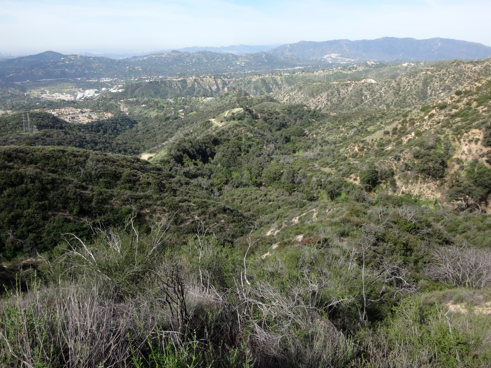
Meanwhile, Dima looked like he just popped out of the most relaxing shower. He agreed though that maybe it was time to scout something else. We started up a super steep slope en route to the east ridge of the canyon. At least we now had some nice views of the watershed.
It was a grind getting up the slope. I made sure to use every possible tree branch and plant as a safety rope. Dima seemed like an invincible goat who down in the stream could have sustained dozens of wasp stings without crying like a baby for several minutes. He found a nice contouring animal trail that shaved off some gain to reach the ridge top.
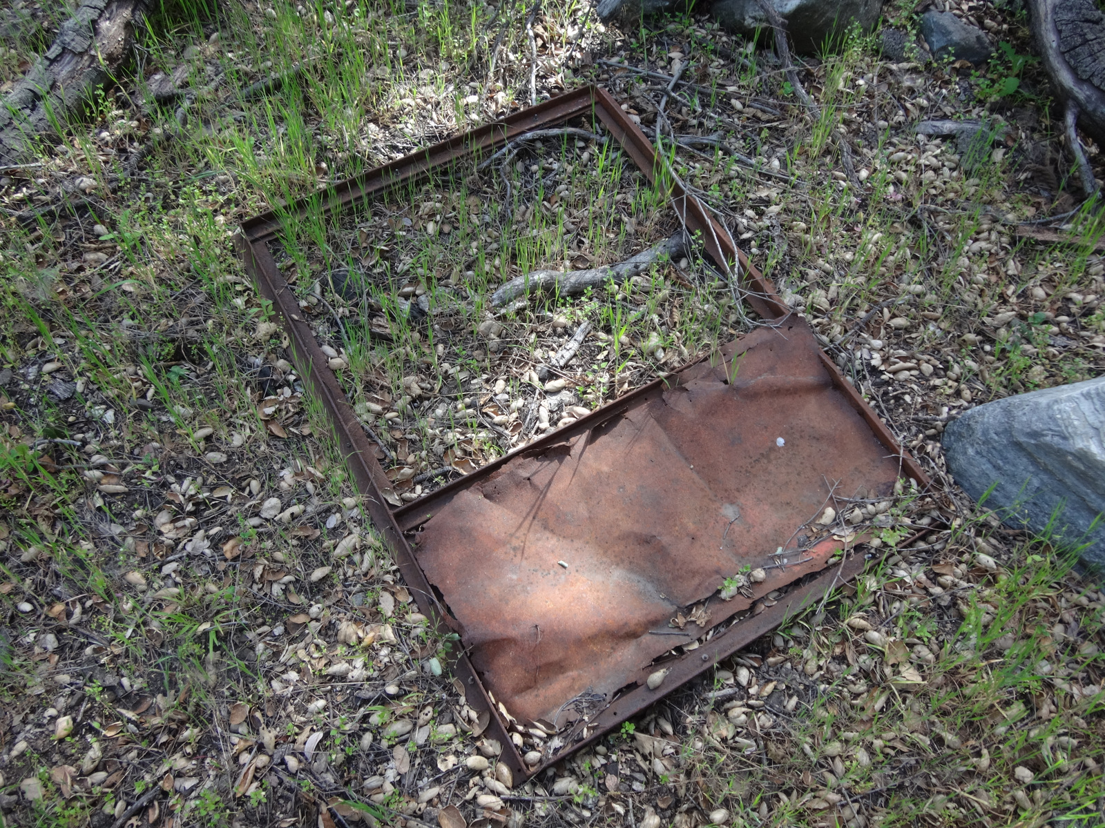
Descending on the ridge made life a lot easier. I only slipped and fell on my ass twice. Also, we happened upon a pretty obvious old trail, which we explored a bit.
On the trail sat this metal artefact.
The ridge took us back to the safety of the truck trail. We called it a day. I tried to end on a positive note by admiring some stupid flower I've seen a million times, yet I still don't know what it's called.
Scouting El Prieto Canyon
-
Sean

- Cucamonga
- Posts: 4467
- Joined: Wed Jul 27, 2011 12:32 pm
You do not have the required permissions to view the files attached to this post.
-
Uncle Rico

- Posts: 1486
- Joined: Thu Mar 20, 2008 7:48 pm
Erysimum capitatum (aka Western Wallflower).
http://www.calflora.org/cgi-bin/species ... ecnum=3472
Looks like a fun day. Glad I wasn't there.
http://www.calflora.org/cgi-bin/species ... ecnum=3472
Looks like a fun day. Glad I wasn't there.
-
Sean
- Cucamonga
- Posts: 4467
- Joined: Wed Jul 27, 2011 12:32 pm
Thanks for the ID. So this kind of flower likes to attend parties but stands off to the side alone and quiet-like?Uncle Rico wrote:Erysimum capitatum (aka Western Wallflower).
-
headsizeburrito

- Posts: 279
- Joined: Wed Nov 15, 2017 1:18 pm
Some people are so forgetful! ?some party campers had forgotten to dispose of their many beer bottles,
Looks like a fun adventure, how close do you guys think you got to the plane wrecks?
-
Girl Hiker

- Posts: 1477
- Joined: Fri Apr 04, 2014 7:46 am
-
dima

- Posts: 1941
- Joined: Wed Feb 12, 2014 1:35 am
- Location: Los Angeles
Maybe 1/3 of the way, ignoring elevation gain. The canyon is narrow and full of plants, so it's slow going, and 1/3 is actually a lot. I'm guessing there're more waterfall obstacles above, but I don't know. Thinking of trying again this weekend. Want to try it?headsizeburrito wrote: Looks like a fun adventure, how close do you guys think you got to the plane wrecks?
-
Sean
- Cucamonga
- Posts: 4467
- Joined: Wed Jul 27, 2011 12:32 pm
I support your attention to spelling. Now let's work on that punctuation!Girl Hiker wrote: I never heard of artefact but i know of ar·ti·fact lol
Artefact is the British spelling of the noun meaning, primarily, an object shaped by human workmanship, especially one of historical or archaeological interest
-
dima
- Posts: 1941
- Joined: Wed Feb 12, 2014 1:35 am
- Location: Los Angeles
-
Sean
- Cucamonga
- Posts: 4467
- Joined: Wed Jul 27, 2011 12:32 pm
On Sunday Ricardo and I scrambled around the middle section of El Prieto looking for more signs of an old trail. First we clawed our way onto the south ridge and dodged bees at the bee boxes before realizing we could have come up the road access on the other side of the boxes. Oh, well!

Then we continued along the ridgetop and peered over the sides, looking for any semblance of an ancient trailbed, perhaps contouring around steeper bits of the ridgeline.

Something that appeared obviously man-made did veer off to the left at the start of the steep ridge ascent to Point 2457.

We followed it around to a minor gully, where it basically faded into oblivion. From there we climbed up a steep use path to Point 2457. Ricardo noticed old clippings during this ascent and put his money on it being a hunter's trail. I then showed him the ART-I-FACTual canteen ring, and also the trail Dima and I found before. But that trail also disappeared into the Twilight Zone once we reached the next substantial gully.

The gully looked difficult to cross, so we backtracked and descended a promising splinter ridge.
This ridge had a decent use path on it, except for one airy bit with a nice potential tumble should one lose their footing.

The bottom of this ridge contained more signs of being a hunter's route. It spit us out into the side gully a short distance from the main stream, above the water company's filter box. At the uppermost debris dam, we started bypassing it on the north slope, when I heard movement on the south side. It was Dima! He said something about having "unfinished business" and getting a "late start." Then he took off upstream, while Ricardo and I continued downstream to look for another artifactional thing that probably doesn't exist anymore, since we didn't find it. But at least we found this
and this.

We figured these items are junk from the construction of the debris dams.
Then we continued along the ridgetop and peered over the sides, looking for any semblance of an ancient trailbed, perhaps contouring around steeper bits of the ridgeline.
Something that appeared obviously man-made did veer off to the left at the start of the steep ridge ascent to Point 2457.
We followed it around to a minor gully, where it basically faded into oblivion. From there we climbed up a steep use path to Point 2457. Ricardo noticed old clippings during this ascent and put his money on it being a hunter's trail. I then showed him the ART-I-FACTual canteen ring, and also the trail Dima and I found before. But that trail also disappeared into the Twilight Zone once we reached the next substantial gully.
The gully looked difficult to cross, so we backtracked and descended a promising splinter ridge.
This ridge had a decent use path on it, except for one airy bit with a nice potential tumble should one lose their footing.
The bottom of this ridge contained more signs of being a hunter's route. It spit us out into the side gully a short distance from the main stream, above the water company's filter box. At the uppermost debris dam, we started bypassing it on the north slope, when I heard movement on the south side. It was Dima! He said something about having "unfinished business" and getting a "late start." Then he took off upstream, while Ricardo and I continued downstream to look for another artifactional thing that probably doesn't exist anymore, since we didn't find it. But at least we found this
and this.
We figured these items are junk from the construction of the debris dams.
-
CrazyHermit

- Posts: 343
- Joined: Mon Sep 07, 2015 1:03 pm
Looks like you got close to Owen Brown's grave marker.
It was stolen, or rather rolled down a hill by an a'hole who lives in the La Vina area, same guy who's responsible for shutting down the mouth of Millard Canyon for ten years.
I've tried to get to it from the residential side, but he's set up motion detectors with alarms and such. This guy's a genuine a'hole, Here's a map if you want to seek it out.
Supposedly it was found in the brush by a hiker and has been replaced.
If you don't know who Owen Brown was, he was the third son of the insurrectionary abolitionist John Brown, and the only one of Brown’s sons who took part in his 1859 raid
on the U.S. armory at Harper’s Ferry to escape alive.

You can find a good writeup on it here .... In search of Owen Brown

Here's what the grave marker looks like if you go searching. I believe one of his descendants moved the body to another location ...

It was stolen, or rather rolled down a hill by an a'hole who lives in the La Vina area, same guy who's responsible for shutting down the mouth of Millard Canyon for ten years.
I've tried to get to it from the residential side, but he's set up motion detectors with alarms and such. This guy's a genuine a'hole, Here's a map if you want to seek it out.
Supposedly it was found in the brush by a hiker and has been replaced.
If you don't know who Owen Brown was, he was the third son of the insurrectionary abolitionist John Brown, and the only one of Brown’s sons who took part in his 1859 raid
on the U.S. armory at Harper’s Ferry to escape alive.
You can find a good writeup on it here .... In search of Owen Brown
Here's what the grave marker looks like if you go searching. I believe one of his descendants moved the body to another location ...
-
Sean
- Cucamonga
- Posts: 4467
- Joined: Wed Jul 27, 2011 12:32 pm
Yes, we went there first. I wrote a separate report for it here.CrazyHermit wrote: Looks like you got close to Owen Brown's grave marker.