

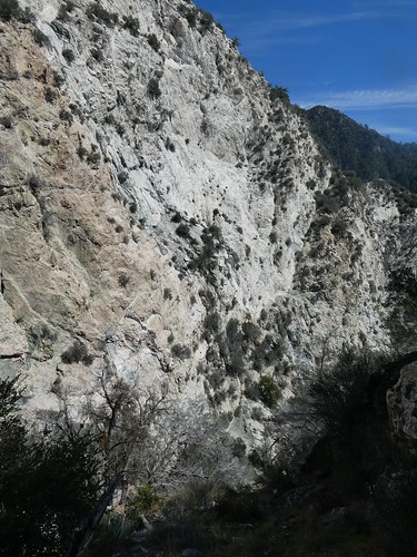
So I arrived at the MtLowe trailhead around 9am. I managed to grab a spot at 1 of the 2 overflow spaces, and a car quickly parked behind me. When I returned it was maxed out as well. Starting from the MtLowe trailhead, it was a nice day. The tunnel had a couple leaks....hmm...and after like forever lol, I was at the Markham/Lowe saddle. Taking the trail up Markham, which is exposed to the sun big time, the beginning to offtrail starts just before the Marham trail really gets moving up. Whether or not to summit Markham is debatable, but the offtrail contours Markham to its southern ridge. There are 3 gullies of the upper reaches of Caltech canyon that barely have a clearing, thanks to the introduction of buckthorn. A landslide is reached and an escape from the brush.
Id been here before last year when the marine layer made it look ridiculously rugged, not to mention completely taking over Markham for awhile, but now it made for much easier travel. This route had me chasing John Muir, who must have been on this same ridge..."My next camp was near the heart of the basin, at the head of a grand system of cascades from ten to two hundred feet high, one following the other in close succession and making a total descent of nearly seventeen hundred feet."
I knew from my last trip that deep Markham SE was not it(I dont even know if thats accessible from this southern ridge...its a long drop down there). Maybe Markham South?
The southern ridge splits into 2, the SE going to subpeak 4870 and mine to subpeak 4631. Its easy going, with Markham South showing off nice forested views. To continue onto peak 4631 was very tempting. I descended into the canyon via a steep draw, with the opposite huge SE ridge wall taking up the view. I followed an animal trail which contoured my side just above the canyon cascades, finally bypassing a 50ft or so drop. There had already been water flowing from where I had hit canyon bottom, but no brush in the way. I was losing elevation fast, so I thought it would be like this the rest of the way. But all of a sudden, the canyon opened up like an amphitheater and I was facing a big waterfall. How big was anyone's guess. The water hit a clear ledge about 20ft down and then it went into huge air and I guessed another 100ft since it was still well above the treetops.
I figured it would be best to check out other options and lazily chose the right side of the canyon. It would take me 45 minutes to get back to the canyon bottom, luckily getting onto a super steep ridge that made it several hundred feet down by that point. I went upstream, but was stopped by a 20ft mucky grotto waterfall. So now it was likely my mission to haul all the unused canyoneering gear I was carrying back to the car. And thats pretty much how it went.
I passed by a side drainage that goes to pk4631 and it looked to be steep but easy to get up to the peak. Nevertheless, this was a bit far from the confluence with Eaton. It was 2 oclock at the confluence as I emptied all my water to lessen the task at hand. Going up Eaton initially I thought it might be better to turn around and try for the Idlehour trail, but it eased up quite a bit. I stayed true to the drainage I was in, closing in on topping out on the Markham side of the tunnel. A rockfall of San Gabriel Peak fell onto the MtLowe trail starting and exciting some mountain bike riders.
After that I drove up to MtWilson. Cosmic Cafe is closed til April. Oh yeah, and the flies are already out.
Mt Lowe on the left, and the landslide

The top of Markham South....with peak 4631 on the right. Across the canyon is subpeak 4602.

Subpeak 4602 behind the tree

 Entering Markham South by desertres, on Flickr
A lot of this on the southern side of the canyon

Post waterfall

canyon travel

