Arroyo Seco: a semi-urban safari

TRs for the San Gabriel Mountains.
Post Reply
User avatar
dima
Posts: 1354
Joined: Wed Feb 12, 2014 1:35 am

Post by dima »

This ended up being a bit long. Sorry.

I like maps and look at them a lot. Maps tell us how our world connects together, without making us go everywhere, but this involves a certain amount of trust. So today I decided to trust, but verify.

As any good LA trip, this one started with a train ride to a hobo trail that led me to the LA river, near the old LA jail. Here I was face to face with the mouth of the Arroyo Seco:

Image

I entered ...

Image

... and very quickly found treasure:

Image

This day was already off to a good start. A bit further upstream, I encountered the first of the day's many waterfalls:

Image

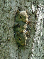
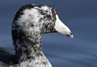
And a bit later, after the sun came up, the first animals were seen:

Image

I kept walking. At some point I popped out of the channel to one of the banks to avoid the Colorado Street dam, that I knew to be a steep pain in the ass from previous explorations. The first major tributary came in a bit later: San Rafael Creek:

Image

After a few miles the Colorado Street bridge came into view:

Image

And the previously-mentioned dam:

Image

Image

Thank you Gray Davis. Past the dam is a soft-bottom section of the arroyo, although the stagnant water really doesn't look very nice.

Image

Then came the Rose Bowl area, full of Pasadena joggers. The channel becomes concrete again here:

Image

I knew it remains a square-sided, fenced-off channel until almost to Devil's Gate dam. Not wanting to be locked in until then, I stayed out, walking along the banks instead. The plan was to stay next to the channel the entire time, but the Rose Bowl golf course people had other ideas. The channel flows down the middle of their fields, and everything is fenced off, without convenient hobo access points, like they have in LA. So I had to walk around, leaving the channel out of my sight for a bit. This would be the perfect opportunity for a prankster map maker to do their thing; I can only hope the channel was indeed where I thought it was.

Past the golf course, I arrived at the 210:

Image

And found a swing set made for people with giant legs but normal torsos:

Image

Devil's Gate dam comes up next, and like the earlier dam, holds back questionable-looking stagnant pools:

Image

The teal stuff is the water. In any case, there isn't much of the wet stuff in the flood plain behind the dam, but there IS a good view of JPL and Brown Mountain:

Image

Underneath the JPL parking lot bridge I found markings for what I assume to be water levels during catastrophic floods. That really puts this drought in perspective; compared to a 10-year flood, we have nothing:

Image

Finally, I made it to the mountains! Above JPL, the Gabrielino is in great shape, and the Arroyo has water in it. I took a break at Gould Mesa, roughly the half-way point. The bypass trail around the Brown Mountain dam is in great shape. And the dam has a nice, little waterfall coming off of it:

Image

Past the dam bypass until Oakwilde, the Arroyo is bone dry, however. The Gabrielino is flagged-out, and the brush cleared here. There's nothing left at Oakwilde, although I didn't look very hard. Above Oakwilde, the water is intermittent, and it's a nice canyon, in general:

Image

The trail is in surprisingly good shape here: people have been working on it. Here I even found some fall colors:

Image

At this point it was about time to look for the alleged junction of the Arroyo Seco and Long Canyon. The Gabrielino follows the latter, but I'm clearly following the former, into Royal Gorge. I walked for a while without finding this junction. Confused, I consulted the GPS, which said that I had missed the junction, but took the correct fork by accident, and I was already in Royal Gorge. I guess that's fine. Royal Gorge is excellent! There was more and more water as I ascended. There are lots of steep sheer cliffs, lots of boulders to hop and pools to admire.

Image

Image

Image

Image

Image

Image

There's also tons of bear scat, and I almost stepped on this guy:

Image

The crux of the trip is in the middle of the Gorge. It's nice waterfall filling a deep pool surrounded by smooth rock. The only possible route for a bypass is on the right. It's not particularly difficult, but it felt a bit unsafe with wet (and slippery) boots. I tried a bigger bypass which turned out to be worse, but by then my shoes dried sufficiently, and I got across the normal way.

Image

Past that waterfall, the going gets easier, and eventually I got to Bear Creek, and Switzer's picnic area. I met some trail workers that were cleaning up the trail to Tom Sloane saddle, so that should be easily passable at some point.

Above Switzer's, I wanted to stay in the creek bed to finish out the main drainage, but daylight was running low, so I took the Gabrielino to Red Box, where my car was sitting. Turns out staying in the creek bed there would be impossible anyway because there were many difficult dams down there:

Image

The Arroyo Seco was dry above Switzer's, and several drainages could claim to be the "main channel". I could see them all from the trail, so I claim going to Red Box was good enough. A good day, overall. It took 11.5 hours to walk 28.7 miles from (almost) downtown LA to see the sun set over the mountains, a red Lawlor and snow.

Image

Image

Image

Image

And the maps of the Arroyo Seco appear to be correct. Except for Long Canyon. That thing is a myth.
User avatar
Uncle Rico
Posts: 1402
Joined: Thu Mar 20, 2008 7:48 pm

Post by Uncle Rico »

Excellent dima. I tried dropping into Oakwilde from Switzer about a year ago on the Gabrieleno. The further into Long Canyon I went, the worse the trail got and I eventually abandoned the effort because I didn't feel like thrashing through the undergrowth. But there was a path there, or at least remnants of one.
User avatar
Sean
Cucamonga
Posts: 3787
Joined: Wed Jul 27, 2011 12:32 pm

Post by Sean »

Super report, and funny too. Congrats on completing your epic. It's amazing what sort of amazing things you see when you do amazing adventures.
User avatar
everyday
Posts: 455
Joined: Tue Mar 15, 2011 12:36 pm

Post by everyday »

thats the saddest, grossest "river" ive ever seen. really sad. i cannot comprehend why you all think its cool. its super sad and horrible, its like a river thats been raped and beaten to death by concrete :( everyone who did that to the river should be burned alive. its a crime against nature. -of course so is all of LA, so wtf, i guess you who live there think its normal...uhg, so gross, i never shoulda looked at this forum again. too depressing.
User avatar
HikeUp
Posts: 3860
Joined: Thu Sep 27, 2007 9:21 pm

Post by HikeUp »

LOL!!!
User avatar
Sean
Cucamonga
Posts: 3787
Joined: Wed Jul 27, 2011 12:32 pm

Post by Sean »

everyday wrote: thats the saddest, grossest "river" ive ever seen. really sad. i cannot comprehend why you all think its cool. its super sad and horrible, its like a river thats been raped and beaten to death by concrete :( everyone who did that to the river should be burned alive. its a crime against nature. -of course so is all of LA, so wtf, i guess you who live there think its normal...uhg, so gross, i never shoulda looked at this forum again. too depressing.
Operator: 911, what's your emergency?
everyday: I'm so depressed.
Operator: Do you have an emergency?
everyday: I want people in LA to die.
Operator: Which people?
everyday: Flood control engineers.
Operator: Why do you want them to die?
everyday: Because they raped Mother Nature.
Operator: Are you reporting a rape?
everyday: I hate concrete.
User avatar
dima
Posts: 1354
Joined: Wed Feb 12, 2014 1:35 am

Post by dima »

thats the saddest, grossest "river" ive ever seen. really sad. i cannot comprehend why you all think its cool. its super sad and horrible, its like a river thats been raped and beaten to death by concrete everyone who did that to the river should be burned alive. its a crime against nature. -of course so is all of LA, so wtf, i guess you who live there think its normal...uhg, so gross, i never shoulda looked at this forum again. too depressing.
The drainages are channelized whether we like it or not, and we all know why it is that way. Hopefully it will be made nicer at some point, and I'll certainly support any effort to do that. But complaining about it or pretending that the channels aren't there is at best unconstructive. In the meantime, they're interesting in their own way, and it was cool to see how the whole thing connects.
User avatar
walker
Posts: 248
Joined: Mon Apr 08, 2013 11:14 pm

Post by walker »

Fantastic trip, Dima. I've always speculated about doing the same thing but going from top to bottom, getting dropped off near Red Box and eventually finishing up by walking to my house in Highland Park. Now I guess I've got to attempt it.
The plan was to stay next to the channel the entire time, but the Rose Bowl golf course people had other ideas. The channel flows down the middle of their fields, and everything is fenced off, without convenient hobo access points, like they have in LA. So I had to walk around, leaving the channel out of my sight for a bit. This would be the perfect opportunity for a prankster map maker to do their thing; I can only hope the channel was indeed where I thought it was.
Near the rose bowl did you take the trail on the west side of the golf course or walk up the road on the east? The west trail allows you to be within view of the channel most of the way and leads you to an area just across the river from the giant swing set.

I also enjoy the trail segment from the York bridge alongside the south pasadena golf course. You get nice views of the driving range and mini golf. There's even a little watercourse in the middle of the golf course that makes me wonder if it's a remnant of an old river tributary channel. It all feels relatively rustic until you cross under the 110 freeway through a sketchy pedestrian tunnel.
And the maps of the Arroyo Seco appear to be correct. Except for Long Canyon. That thing is a myth.
To access Long Canyon, the Gabrieleno trail used to start up the north bank a bit early, before its creek drops in from the left. It wasn't so much a confluence as a spot where the creek dropped straight down a cliff as a waterfall into the Arroyo. With a low or non-existent water flow in Long Canyon, it might just look like a cliff. Long Canyon lives up to its name. It used to have a real dense canopy and felt like a long, dark tunnel.
The trail is in surprisingly good shape here: people have been working on it.
I was at the top of the Ken Burton trail today and ran into a fellow who's been doing some trail work up there. Several volunteer groups are coordinating with the ANF and apparently the plan is to try to open access to the Ken Burton-Arroyo loop sometime next year. He didn't know about the Gabrieleno, Switzter to Long Canyon section, but I imagine that's probably in the works as well.

Great job!
User avatar
mattmaxon
Posts: 1137
Joined: Mon Mar 24, 2008 12:48 pm

Post by mattmaxon »

EPIC! The Good the bad and the ugly of los angeles

The flood control "It seemed like a good idea at the time" mans mastery over nature and all that BS

Long Cyn is there, though it is easy to miss.

Royal "pain" Gorge is the long way around for sure. Done that twice, after the fire and before the first big flood was the best, the first time endless boulder hopping got old.
User avatar
tekewin
Posts: 1195
Joined: Thu Apr 11, 2013 5:07 pm

Post by tekewin »

Wild trip, Dima, and educational. Maps can't tell you the things you learned.

I wonder what they are hiding in that golf course. Hmmm.
User avatar
dima
Posts: 1354
Joined: Wed Feb 12, 2014 1:35 am

Post by dima »

walker wrote: Near the rose bowl did you take the trail on the west side of the golf course or walk up the road on the east? The west trail allows you to be within view of the channel most of the way and leads you to an area just across the river from the giant swing set.
Yeah, I used the west-side road and trail. You can kinda sorta see the channel from there. The trail is nice, though.
walker wrote: I also enjoy the trail segment from the York bridge alongside the south pasadena golf course. You get nice views of the driving range and mini golf. There's even a little watercourse in the middle of the golf course that makes me wonder if it's a remnant of an old river tributary channel. It all feels relatively rustic until you cross under the 110 freeway through a sketchy pedestrian tunnel.
I like that section too! It's nicely hidden, and you wouldn't know there's a trail unless you looked for it. I skipped all that this trip though: stayed at the channel bottom until the walls become vertical at San Pascual.
walker wrote: To access Long Canyon, the Gabrieleno trail used to start up the north bank a bit early, before its creek drops in from the left. It wasn't so much a confluence as a spot where the creek dropped straight down a cliff as a waterfall into the Arroyo. With a low or non-existent water flow in Long Canyon, it might just look like a cliff. Long Canyon lives up to its name. It used to have a real dense canopy and felt like a long, dark tunnel.
At this point I'm pretty sure that the waterfall in one of the photos (with a stick at the bottom) IS the Long Canyon creek. As you and others have said, the trail climbs the bank first, before joining the Long Canyon channel. And since the trail isn't in ideal shape right now, I didn't see it.
walker wrote: I was at the top of the Ken Burton trail today and ran into a fellow who's been doing some trail work up there. Several volunteer groups are coordinating with the ANF and apparently the plan is to try to open access to the Ken Burton-Arroyo loop sometime next year. He didn't know about the Gabrieleno, Switzter to Long Canyon section, but I imagine that's probably in the works as well.
That's good to hear, and I actually know one of the people helping reopen the Ken Burton. Mountain Bikers get excited about that loop. The hikers I met at Oakwilde the last time I was there (last trip report) came from Long Canyon and said that the trail on the hill is decent, and in the canyon is a bushwhack. I'll visit sometime.
User avatar
dima
Posts: 1354
Joined: Wed Feb 12, 2014 1:35 am

Post by dima »

I forgot to mention numerous signs in the Lower Arroyo park (between San Pascual and Colorado) warning about heavy coyote and mountain lion presence (separate signs for each), and what to do when encountering the animals. I'm certain there're lots of coyotes, but dubious about there being any mountain lions at all down there.
User avatar
AW~
Posts: 2042
Joined: Mon Oct 01, 2007 12:00 pm

Post by AW~ »

Interesting...what led you to plan this trip?
User avatar
dima
Posts: 1354
Joined: Wed Feb 12, 2014 1:35 am

Post by dima »

AW wrote: Interesting...what led you to plan this trip?
We've all seen the various sections of the Arroyo on separate trips, but for most of us, a line on a map is the only indication we have that the river at Switzer's falls and the one below the Colorado bridge (for instance) are one and the same. I wanted to see all the transitions.
User avatar
Sean
Cucamonga
Posts: 3787
Joined: Wed Jul 27, 2011 12:32 pm

Post by Sean »

dima wrote: The drainages are channelized whether we like it or not, and we all know why it is that way.
I'm sure you know, but it seems like some other people here actually don't know or appreciate the reasons why the Arroyo Seco, and other streams, were channelized. Perhaps they don't know how terrible the pre-channelization floods were upon life and property. And perhaps they don't understand the value of having a concrete versus soft bottom in the channel during a massive storm, when rapidly moving water out of the channel becomes critically important.

I would like to think that people's disdain for the channels comes out of ignorance and misguided emotion rather than a principled hatred of man's need to protect himself from the forces of nature. But I went to college in California and met quite a few nature-worshipping environmentalists, so I'm skeptical.

This is actually an important debate. If the consensus shifts and people vote down flood control measures, then what do you think will ultimately happen? The existing structures will deteriorate and we'll have 1938 all over again. Maybe that's what some people want to happen. At least then the stream would be free-flowing and unhindered by mankind's raping concrete, right? Never mind the devastation to civilization.
User avatar
dima
Posts: 1354
Joined: Wed Feb 12, 2014 1:35 am

Post by dima »

dima wrote: I forgot to mention numerous signs in the Lower Arroyo park (between San Pascual and Colorado) warning about heavy coyote and mountain lion presence
Here's the sign they have posted in multiple places:

http://www.cityofpasadena.net/WorkArea/ ... 6442454930

There can't seriously be cougars down there, right? This is south of Colorado Ave.
User avatar
dima
Posts: 1354
Joined: Wed Feb 12, 2014 1:35 am

Post by dima »

Sean wrote: This is actually an important debate. If the consensus shifts and people vote down flood control measures, then what do you think will ultimately happen? The existing structures will deteriorate and we'll have 1938 all over again. Maybe that's what some people want to happen. At least then the stream would be free-flowing and unhindered by mankind's raping concrete, right? Never mind the devastation to civilization.
If these things were built today, I suspect it would be done in a less heavy-handed way with (hopefully) more pleasing results.

Also, while the current structures are effective as flood-control measures, they're very poor for another purpose we're discovering is important: water capture. Instead of shipping flood waters to the ocean as quickly as possible, it'd be great to store the water for later use.

And a yet-other issue is that the channels are as trashy as they are primarily because of LA's out-of-control homelessness problem.

It's difficult and expensive (and somewhat unclear) how to sort all of that out, but it'll happen in time. In the meanwhile, let's try to enjoy what we have.
User avatar
oldcoot
Posts: 64
Joined: Wed Jun 16, 2010 9:42 pm

Post by oldcoot »

User avatar
Shangri-LA
Posts: 24
Joined: Sun Nov 15, 2015 2:27 pm

Post by Shangri-LA »

everyday wrote: thats the saddest, grossest "river" ive ever seen. really sad. i cannot comprehend why you all think its cool. its super sad and horrible, its like a river thats been raped and beaten to death by concrete :( everyone who did that to the river should be burned alive. its a crime against nature. -of course so is all of LA, so wtf, i guess you who live there think its normal...uhg, so gross, i never shoulda looked at this forum again. too depressing.
Looks like you missed the whole point. There are both heavily impacted and largely "wild" portions of the Arroyo. It's pretty cool to witness the connectivity between them in one direct journey.
User avatar
Shangri-LA
Posts: 24
Joined: Sun Nov 15, 2015 2:27 pm

Post by Shangri-LA »

What a cool journey! I'm sure I could find it, but do you happen to have a waypoint for either of the waterfalls pictured (Royal Gorge or suspected Long Canyon)?
User avatar
dima
Posts: 1354
Joined: Wed Feb 12, 2014 1:35 am

Post by dima »

Shangri-LA wrote: What a cool journey! I'm sure I could find it, but do you happen to have a waypoint for either of the waterfalls pictured (Royal Gorge or suspected Long Canyon)?
Sure. The suspected Long Canyon fall would be at its confluence:

http://www.openstreetmap.org/#map=18/34 ... 9&layers=C

I added the main falls in Royal Gorge to OSM. Waterfalls aren't rendered in the default layer, but you can see it in the data:

http://www.openstreetmap.org/node/3870336597
User avatar
Shangri-LA
Posts: 24
Joined: Sun Nov 15, 2015 2:27 pm

Post by Shangri-LA »

dima wrote:
Shangri-LA wrote: What a cool journey! I'm sure I could find it, but do you happen to have a waypoint for either of the waterfalls pictured (Royal Gorge or suspected Long Canyon)?
Sure. The suspected Long Canyon fall would be at its confluence:

http://www.openstreetmap.org/#map=18/34 ... 9&layers=C

I added the main falls in Royal Gorge to OSM. Waterfalls aren't rendered in the default layer, but you can see it in the data:

http://www.openstreetmap.org/node/3870336597
Thanks for that. I have never seem osm, so it's interesting.
User avatar
Mike P
Posts: 1005
Joined: Tue Oct 02, 2007 10:48 pm

Post by Mike P »

Thanks, dima for the trip. Amazing!

Also, the two-striped garter snake was cool. Good to see that they are still in the Arroyo.
Post Reply