
Decided to take the old SCE tractor road trail up to W. Fuji from the mouth of Rubio Canyon today and on the way noticed it was appearing more washed out than usual. Just very narrow with lots of slippery scree and sand. Wasn't like this last time I went up about a month ago.
I kept encountering wash outs of increasing severity until I get to the point where the trail takes a hard left turn at Pine Canyon, and a huge chunk of the trail appears to have washed down into the canyon.
From my vantage point it was not passable to continue on. There just wasn't any clear continuation of the path without doing some very sketchy scrambling over crumbling rock. There was however a way to get down into the upper reaches of Pine Canyon, if one were so inclined to do so. But I don't think this trail is usable to get to W. Fuji at this point.
Just thought I would give you guys a heads up in case you decided to go this way.
Gooseberry Motorway (SCE Tractor Trail)
-
HikeUp

- Posts: 4070
- Joined: Thu Sep 27, 2007 9:21 pm
Great update. That would suck to come down that way and come across an impassable section near the bottom.
-
dima

- Posts: 1859
- Joined: Wed Feb 12, 2014 1:35 am
- Location: Los Angeles
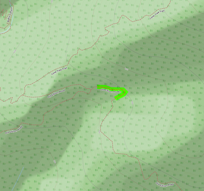
Thanks for the update. Is the washout here: http://www.openstreetmap.org/#map=19/34 ... -118.11957
or here: http://www.openstreetmap.org/#map=19/34 ... -118.11407
? I'm updating the map.
or here: http://www.openstreetmap.org/#map=19/34 ... -118.11407
? I'm updating the map.
-
sesshin
- Posts: 24
- Joined: Tue Nov 12, 2013 11:53 pm
Okay, I did a quick jaunt back up here this morning just to verify. Didn't want to be spreading bad info on the internet.
It looks like I was mistaken. The SCE tractor trail is still navigable upwards to Lone Tree Trail. It was just that the upward heading trail is obstructed by plants, making it easy to miss. If you are going that way and don't know where the junction is its very easy to continue on the trail into Pine Canyon.
The trail is completely washed out as it continues on into Pine Canyon however. I've marked it on the map. It looks like you can slide down into the canyon and then maybe back up on the other side but its pretty technical and not safe for the average hiking crowd by any means.
This might be common knowledge to the guys on here. I think it might have been covered in another thread.
I apologize if my initial misinformation caused any concern for anyone
-
Sean

- Cucamonga
- Posts: 4289
- Joined: Wed Jul 27, 2011 12:32 pm
That stretch of the SCE road is pretty solid and has been for nearly a century. It does however get overgrown and covered in slough. There are also ticks and rattlesnakes in there.
I don't recommend trying to follow the road to the Pine/Gooseberry Cyn crossing. To my knowledge that part is gone.
It's possible to scramble down to the streambed via one of the gullies before the cistern. I've come up to the road from the Surprise Mine. But it's not easy. Use the power lines to gauge your position in the Canyon when down below.
-
stonehillnews
- Posts: 85
- Joined: Thu Dec 15, 2016 1:31 pm
Listening to some Type O Negative while engaging in some thread necromancy 
I was recently doing some updates to OSM (see 34.2022,-118.1111?z=16), and found this post as a reference for the map edit in November 2015 by Dima when the Old Edison Road washed out Gooseberry Canyon crossing was removed.
So I thought in addition to updating the map, I better also set the record straight here. The after photo shown below was taken last Sunday, February 26th, 2017, and shows what used to be the sketchiest class 4 segment, now restored to a class 3, if not a class 2 path.
Also, here's a spherical image of it from a couple weeks ago.
Before
October 2, 2016
After
February 26, 2017
The whole Gooseberry Motorway, aka SCE Tractor Road, aka Old Edison Road, from Rubio Canyon Reservoir to the west wall of Eaton Canyon is currently passable. It is flagged from the fork near the sombrero cistern (at the turnoff from the connector to the Lone Tree) all the way to the Eaton Closure Area. The firebreak up the east ridge to West Fuji is also flagged. It has had very minimal work done on brush clearance, but it is still a pretty typical overgrown firebreak scramble/bushwhack.
-
stonehillnews
- Posts: 85
- Joined: Thu Dec 15, 2016 1:31 pm
Here's a pretty great historical document obtained by Paul Ayers from COLA Fire.
The Construction Notes seem to say:
The Construction Notes seem to say:
So this indicates the road was effectively abandoned some time before November 1964, and was officially abandoned sometime after that.No one can make up their mind
to aband or maint; nothing being done
on it at this time, Luier 11-64
ABANDON
-
David R
- OG of the SG
- Posts: 654
- Joined: Sun Jun 12, 2011 10:28 pm
The work done to make this hikable is significant and it is readily accessible to most hikers. It would be a stretch to call this Class 2 so anyone who wants to check it out should not be intimidated.
-
Huff and Puff
- Posts: 35
- Joined: Sun Feb 07, 2016 1:33 pm
The spherical image is cool. Gives the picture a greater sense of depth.
-
stonehillnews
- Posts: 85
- Joined: Thu Dec 15, 2016 1:31 pm
Thanks everybody 8)
Hi David, did you mean it would be a stretch to call it class 2, because it's actually a class 1?David R wrote: The work done to make this hikable is significant and it is readily accessible to most hikers. It would be a stretch to call this Class 2 so anyone who wants to check it out should not be intimidated.
-
Hayduke
- Posts: 36
- Joined: Sun Sep 06, 2009 2:18 pm
really great trail work, and awesome find with the historical documents.
-
sesshin
- Posts: 24
- Joined: Tue Nov 12, 2013 11:53 pm
Took this a few days ago and it is really nice to be able to go from Rubio to Eaton in a direct route. I appreciate all the effort that has gone into it so far. kind of closes a loop in a trail system connecting the Altadena Crest trail, up to W. Fuji, up to Muir Peak, etc.
still rough around the edges, especially over by Eaton. kind of have to worry about people wandering into the closure areas. But the view over there into the canyon is really nice.
I had cleared parts of the old SCE trail on my own about a year or two ago around the electrical towers. probably saw some of my rope work (got the ropes btw)
still rough around the edges, especially over by Eaton. kind of have to worry about people wandering into the closure areas. But the view over there into the canyon is really nice.
I had cleared parts of the old SCE trail on my own about a year or two ago around the electrical towers. probably saw some of my rope work
-
stonehillnews
- Posts: 85
- Joined: Thu Dec 15, 2016 1:31 pm
Oh, that was you who placed the ropes. Thanks for those. Yeah, I coiled them and hung them in the branches at each spot, and I recently noticed they were gone. Glad it was you who got them. Of course the one by that remaining sketchy spot is still installed. Maybe this spring I'll get that last gully sorted out. As you say, the closer you get to Eaton, the rougher things are, but with that one gully as the main exception, it's primarily brushing that's needed.
-
tonesfrommars

- Posts: 17
- Joined: Thu Apr 26, 2018 10:15 pm
Walked motorway to edge of Eaton Cyn and up the firebreak to West Fuji this morning. LOTS OF TICKS on the firebreak, beware. There's no way to get up it without thrashing through the brush. Otherwise, beautiful.
You do not have the required permissions to view the files attached to this post.
-
stonehillnews
- Posts: 85
- Joined: Thu Dec 15, 2016 1:31 pm
Truth. Sean and I lost count a few weeks back. Hundred plucked off pants.tonesfrommars wrote:LOTS OF TICKS