
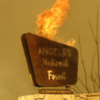
Cabin Fire - shit!
-
Wild
- Posts: 40
- Joined: Tue Jan 18, 2011 11:38 am
I was just about to post about it. Damnit! Not again 
Here's another link http://ktla.com/2015/08/14/firefighters ... ove-azusa/
Here's another link http://ktla.com/2015/08/14/firefighters ... ove-azusa/
-
HikeUp

- Posts: 4097
- Joined: Thu Sep 27, 2007 9:21 pm
Seems to be burning the northwestern face of the ridge that runs from Burro Peak all the way up to near Rattlesnake. Or in other words it is making a run up Bichota Canyon. Might jump over to Pigeon Ridge at some point.
-
Mike P

- Posts: 1005
- Joined: Tue Oct 02, 2007 10:48 pm
I agree HikeUp, judging by the TV coverage it looks like the fire may make a run up Bichota. What a shame. I thought the the Curve Fire charred the place years ago. Maybe, it will be time to put in a new trail!
2011 TR from Bichota Canyon: Bichota Canyon
2011 TR from Bichota Canyon: Bichota Canyon
-
HikeUp
- Posts: 4097
- Joined: Thu Sep 27, 2007 9:21 pm
Yep Mike. A couple of googles today revealed to me that there is a supposed trail up Bichota to Rattlesnake!? Time to renovate that one!
I wonder if this started at the Mesa in a weird ritual too.
I wonder if this started at the Mesa in a weird ritual too.
-
walker

- Posts: 248
- Joined: Mon Apr 08, 2013 11:14 pm
A few years after the Curve fire, I managed to navigate the switchbacks of the "trail" seen on topos from Bichota canyon up a southern drainage to the Rattlesnake/Burro ridge.Yep Mike. A couple of googles today revealed to me that there is a supposed trail up Bichota to Rattlesnake!? Time to renovate that one!
http://caltopo.com/map.html#ll=34.26929 ... 1&z=15&b=t
It was very hard to find from below, but once on top and descending from the ridge, you could pick it out and descend the switchbacks most of the way through a chaparral tunnel along a relatively intact trail bed. If the Cabin fire passed through that area, it may be easier to find those switchbacks again and get on top of the ridge. Once you're up there, travel seems a lot easier along the fire break. However, recovering the upper section of the trail where it drops back into Bichota canyon may be another matter.
-
Mike P
- Posts: 1005
- Joined: Tue Oct 02, 2007 10:48 pm
Oh no, another trail on the to-do list! I hadn't looked at the topo of that area. I don't believe that the fire burned the upper section that descends back into Bichota.walker wrote:A few years after the Curve fire, I managed to navigate the switchbacks of the "trail" seen on topos from Bichota canyon up a southern drainage to the Rattlesnake/Burro ridge.Yep Mike. A couple of googles today revealed to me that there is a supposed trail up Bichota to Rattlesnake!? Time to renovate that one!
http://caltopo.com/map.html#ll=34.26929 ... 1&z=15&b=t
It was very hard to find from below, but once on top and descending from the ridge, you could pick it out and descend the switchbacks most of the way through a chaparral tunnel along a relatively intact trail bed. If the Cabin fire passed through that area, it may be easier to find those switchbacks again and get on top of the ridge. Once you're up there, travel seems a lot easier along the fire break. However, recovering the upper section of the trail where it drops back into Bichota canyon may be another matter.
I'd love to do a North Fork to East Fork hike!
-
David R
- OG of the SG
- Posts: 684
- Joined: Sun Jun 12, 2011 10:28 pm
I found the remnants of the trail from Bichota Canyon. There is a flat section on the south side of the creek where there was a slightly obvious climb up onto the bank. Once you started across this section the brush became thicker. I was able to make my way up only 50-60 feet before I got to a rock fall and could no longer tell where the trail was. The rockfall was pretty loose and after sliding on it a bit and with no sign of the trail on the other side, I called it a day and turned around to continue to explore the canyon.
-
EBruddah
- Posts: 20
- Joined: Thu Aug 20, 2015 4:38 pm
Accessing Bichota easier is certainly a silver lining to this event. Fire's stomped out and it's in mop up phases right now. Still closed up to East Fork. But from what I've heard Bear Creek is still accessible however Crystal Lake and Coldbrook Campgrounds opening is still not announced as of this evening. Let's hope it opens up again for Labor Day. I want to hit Little Jimmy before the end of the summer.
-
EBruddah
- Posts: 20
- Joined: Thu Aug 20, 2015 4:38 pm
Just a reminder of current conditions per USFS on ANF
http://www.fs.usda.gov/angeles/
http://www.fs.usda.gov/angeles/
Closures
Hwy 39 is open to the West Fork Road at approx. mile marker 26.91. The remaining portion of Hwy 39 will be closed until further notice due to the Cabin Fire.
West Fork Road is Closed.
Glendora Ridge Road is closed until further notice due to road conditions.
Crystal Lake Recreation Area campground & Fawnskin Picnic Area will remain closed until further notice.
Coldbrook Campground is closed until further notice.
Glendora Mountain Road is open.
Openings
East Fork Road is open.
Rincon Road is open with a permit.
Off Highway Vehicle Area will be open this weekend, Sat. & Sun. from 8:00 to 4:00 p.m. Exit by 4:30 p.m.
-
SGBob
- Posts: 101
- Joined: Wed Jan 07, 2015 12:47 pm
The USFS has issued a closure order for most of the Cabin Fire burn area.
http://www.fs.usda.gov/Internet/FSE_DOC ... 851663.pdf
http://www.fs.usda.gov/Internet/FSE_DOC ... 851663.pdf
-
EBruddah
- Posts: 20
- Joined: Thu Aug 20, 2015 4:38 pm
That's just the area, not the road, correct? Well it sucks but it needs to recover. As long as they don't close the road we're good. I can live without that area for a year. I'm just going to miss Smith Mountain.
-
oldcoot
- Posts: 64
- Joined: Wed Jun 16, 2010 9:42 pm
I think you can still do Smith Mountain via the standard HPS routes...it looks like they don't go through the closed area...and the closure order says you can drive through the area, just can't stop or park...
Coming back down Smith to the saddle was scary...once was enough for me...
oldcoot
Coming back down Smith to the saddle was scary...once was enough for me...
oldcoot
-
Taco

- Snownado survivor
- Posts: 6214
- Joined: Thu Sep 27, 2007 4:35 pm
I was going to post that order, thanks for the better one and doing it sooner, Bob!
I visited the burn area the other day. Just driving through, no hiking or anything. All those really awesome huuuuge ferns and Humboldt Lilies living in the canyons on the southeast aspect of Smith Mtn have burned. It was like being in Jurassic Park in one of em. Shame it's gone.
The little hamlet at the edge of Bichota Canyon burned AGAIN. That same spot burned in the Curve Fire, no?
-
HikeUp
- Posts: 4097
- Joined: Thu Sep 27, 2007 9:21 pm
I recall the Curve fire started there during a ritual of some sort.
-
Taco
- Snownado survivor
- Posts: 6214
- Joined: Thu Sep 27, 2007 4:35 pm
Yeah, a Santeria thing. I found something related to that near Bichota Canyon's mouth a few years ago.