
I don't know if anyone is following the Lake Fire, but I've got detailed topo maps with the fire perimeter added as an overlay on my blog:
Lake Fire
HJ
Lake Fire -- Detailed Maps
-
HikeUp

- Posts: 4070
- Joined: Thu Sep 27, 2007 9:21 pm
Great info HJ. Sad. Thanks for the hard work.
-
Uncle Rico

- Posts: 1484
- Joined: Thu Mar 20, 2008 7:48 pm
Thanks for the good info you're putting up here and elsewhere Jimbo. Major bummer. 
-
Hikin_Jim

- Posts: 4688
- Joined: Thu Sep 27, 2007 9:04 pm
Yeah, hard to put a good spin on it.
The good news is that this fire like all fires is patchy. There are going to be some spots barely scratched -- and others that are nothing but scorched earth. I saw a photo of Poopout Hill yesterday. Scorched earth.
HJ
The good news is that this fire like all fires is patchy. There are going to be some spots barely scratched -- and others that are nothing but scorched earth. I saw a photo of Poopout Hill yesterday. Scorched earth.
HJ
-
Hikin_Jim
- Posts: 4688
- Joined: Thu Sep 27, 2007 9:04 pm
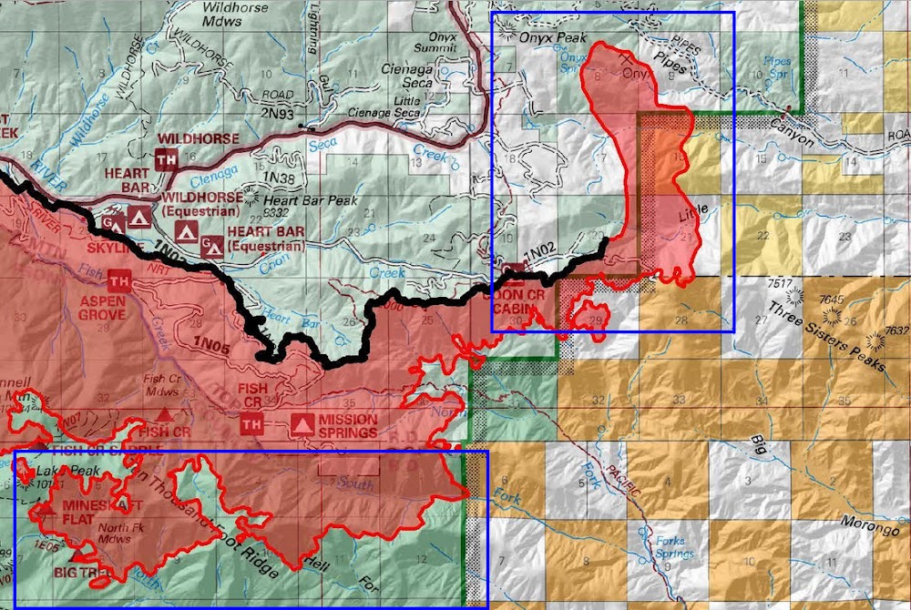
Looks like the Lake Fire is now making a run for Big Tree Camp. MODIS is showing a lot of thermal activity in the area which indicates an actively burning fire. I don't like the idea of Big Tree Camp burning, but it wouldn't bother me in the least to have the brush in the bottom of the canyon of the drainage of the N Fork of the Whitewater River cleaned out.
I've changed the second of my two maps to include the MODIS hot spots (bright red dots) if you want to see what I'm blathering about. They are NOT very precise, but they do indicate fire in the general vicinity.
See: Lake Fire Maps
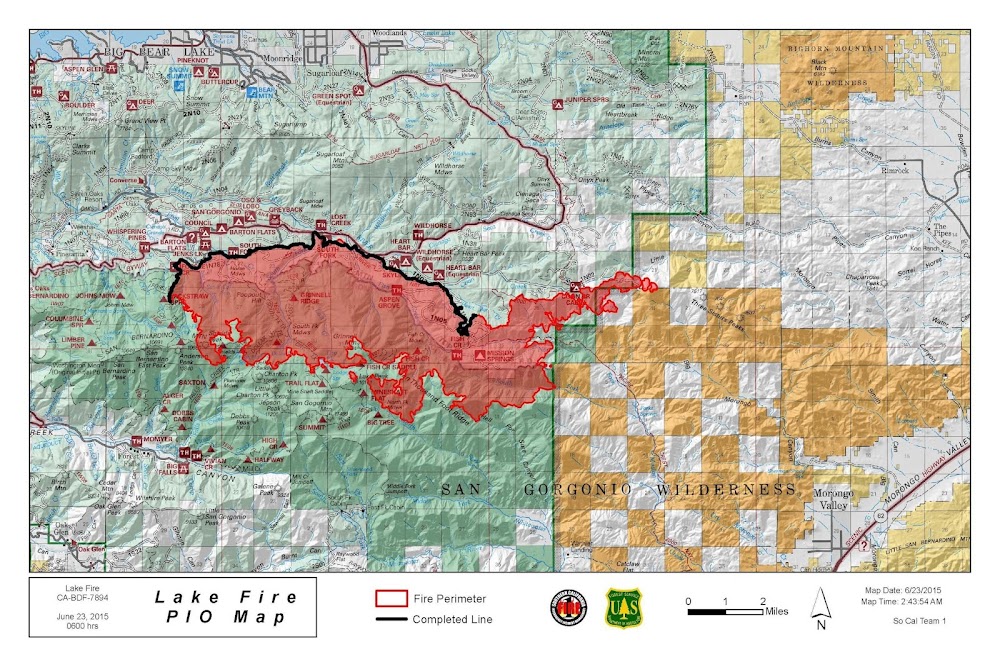
I've also added the latest US Forest Service PIO fire perimeter map in the Appendix as well as below.
HJ
I've changed the second of my two maps to include the MODIS hot spots (bright red dots) if you want to see what I'm blathering about. They are NOT very precise, but they do indicate fire in the general vicinity.
See: Lake Fire Maps
I've also added the latest US Forest Service PIO fire perimeter map in the Appendix as well as below.
HJ
-
tekewin

- Posts: 1392
- Joined: Thu Apr 11, 2013 5:07 pm
Thanks for the tracking this, HJ. I can't believe so much was burned so quickly.
-
Hikin_Jim
- Posts: 4688
- Joined: Thu Sep 27, 2007 9:04 pm
Yeah, it's pretty frickin' incredible. In a bad way. And we're not out of the proverbial woods yet.
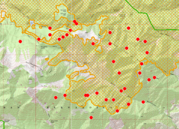
Looking at the latest MODIS data, there is active fire on the SW slopes of Ten Thousand Foot Ridge.
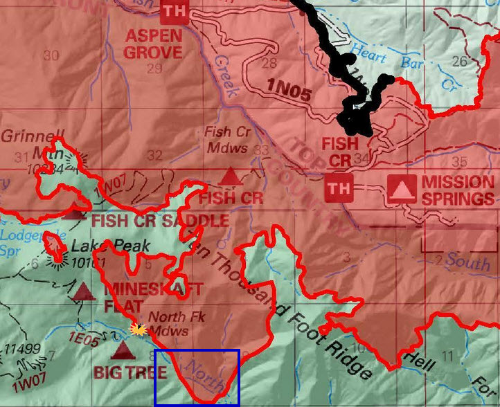
The latest PIO map shows that the fire has now crossed the N Fork of the Whitewater River and is on the opposite bank (highlighted with a blue rectangle). Big Tree Camp may have now burned. The position of the camp shown by the USFS is wrong. The camp is on the east side of the river where I've put the yellow splash symbol.
HJ
Looking at the latest MODIS data, there is active fire on the SW slopes of Ten Thousand Foot Ridge.
The latest PIO map shows that the fire has now crossed the N Fork of the Whitewater River and is on the opposite bank (highlighted with a blue rectangle). Big Tree Camp may have now burned. The position of the camp shown by the USFS is wrong. The camp is on the east side of the river where I've put the yellow splash symbol.
HJ
-
Mike P

- Posts: 1005
- Joined: Tue Oct 02, 2007 10:48 pm
Thanks, HJ. I haven't been down to Big Tree. Been to Mine Shaft about three times, though. That is a beautiful canyon!
I'm looking forward to the slow rebirth of the SGW!
I'm looking forward to the slow rebirth of the SGW!
-
Mike P
- Posts: 1005
- Joined: Tue Oct 02, 2007 10:48 pm
Dang it! It looks like Mineshaft and Big Tree were burned yesterday.
-
Hikin_Jim
- Posts: 4688
- Joined: Thu Sep 27, 2007 9:04 pm
Yep. Toast.Mike P wrote: Dang it! It looks like Mineshaft and Big Tree were burned yesterday.
I've added a fire progression map to my blog post on the Lake Fire. Lots of fire growth in the N Fork of the Whitewater.
I've also added a "tally" of what Trail Camps have/have not burned:
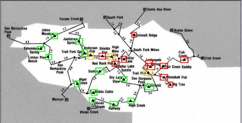
Red = burned.
Yellow = possibly burned.
Green = unburned.
HJ
-
Hikin_Jim
- Posts: 4688
- Joined: Thu Sep 27, 2007 9:04 pm
6/24/2015 Evening Updates:
1. The Lake Fire has a made a run to the north of about three miles that is nothing short of dramatic. See areas with blue rectangles on the below map.
2. The Forest Service issued an order closing the entire SGW, including those areas not affected by the fire, until October 1, 2015. Closure map on my blog.
HJ
-
Mike P
- Posts: 1005
- Joined: Tue Oct 02, 2007 10:48 pm
That sure explains all of the smoke as viewed from the Rancho Cucamonga area today
-
Hikin_Jim
- Posts: 4688
- Joined: Thu Sep 27, 2007 9:04 pm
It's a sad day for San Gorgonio Wilderness lovers. The Lake Fire burned up the east flanks of San Gorgonio Mountain up to and past the Sky High Trail. It may reach all the way to the krummholz at the very summit later today. Bighorn Mountain's east flank has also burned up to somewhere around 10,000 feet elevation. The entire San Gorgonio Wilderness and the PCT to the east is closed until 01 Oct 2015 per Forest Order.
Details and maps on my blog
HJ
Details and maps on my blog
HJ
-
Mike P
- Posts: 1005
- Joined: Tue Oct 02, 2007 10:48 pm
Thanks, Jim, for all of your work on the maps.
It's so disappointing (depressing?) that the line didn't hold up on 10,000 Foot Ridge...
It's so disappointing (depressing?) that the line didn't hold up on 10,000 Foot Ridge...
-
Hikin_Jim
- Posts: 4688
- Joined: Thu Sep 27, 2007 9:04 pm
Yeah. It would have been good to have stabilized the fire inside the SGW. But no.
The fire has burned up to nearly 10,500 on the flanks of Bighorn Mountain which is immediately south of San Gorgonio Mountain. I really hope the dwarf forests up there don't burn. It' would be centuries before they'd come back.
Good news is that the perimeter within the SGW hasn't grown much. There is however a lot of active burning going on. And the fire has made major north and east expansions outside the wilderness.
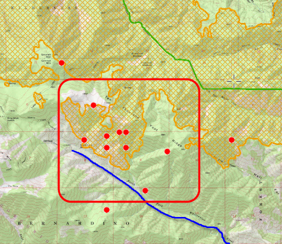
MODIS (thermal data) plot on a topo:
Additional updates and new maps on blog.
HJ
The fire has burned up to nearly 10,500 on the flanks of Bighorn Mountain which is immediately south of San Gorgonio Mountain. I really hope the dwarf forests up there don't burn. It' would be centuries before they'd come back.
Good news is that the perimeter within the SGW hasn't grown much. There is however a lot of active burning going on. And the fire has made major north and east expansions outside the wilderness.
MODIS (thermal data) plot on a topo:
Additional updates and new maps on blog.
HJ
-
AW~

- Posts: 2110
- Joined: Mon Oct 01, 2007 12:00 pm
Another news was that the old fire mgmt(Type 2) team was sacked and now there is a type 1 team in there.
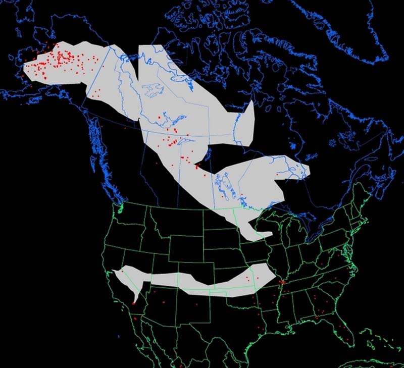
"Wildfire smoke in North America" as of 6/25/15...as smoke from the Lake fire looks to meet smoke from the Juneau fire at Illinois.
"Wildfire smoke in North America" as of 6/25/15...as smoke from the Lake fire looks to meet smoke from the Juneau fire at Illinois.
-
Tom Kenney

- Posts: 386
- Joined: Sat Sep 29, 2007 7:51 pm
Drone flying over forest fire diverts planes, costs US Forest Service $10K
Wasn't a fan of 'personal' drones before... much, MUCH less so now!
Wasn't a fan of 'personal' drones before... much, MUCH less so now!