
Happy New Years to all my SGMDF peeps.
2015 in the San Gabes
-
Uncle Rico

- Posts: 1484
- Joined: Thu Mar 20, 2008 7:48 pm
Just wondering what's on everyone's San Gabriel Mountains bucket list for 2015. For me, I'd like to get to Dawson and Iron, get out on Winston and Kratka Ridges, drop down into Fish Fork, explore the east fork of Santa Anita Canyon, descend Shortcut Canyon to West Fork and Devore trail camps, and make it out to Idlehour just to name a few. What's everyone else plan on doing?
Happy New Years to all my SGMDF peeps.
Happy New Years to all my SGMDF peeps.
-
fortified
- Posts: 105
- Joined: Sat Mar 02, 2013 10:03 pm
I have the same goal I have had for 20 years
Hike from one side, somewhere around Altadena, to the other side in the upper desert.
One day, I will do it
Hike from one side, somewhere around Altadena, to the other side in the upper desert.
One day, I will do it
-
dima

- Posts: 1923
- Joined: Wed Feb 12, 2014 1:35 am
- Location: Los Angeles
Great question! I will finally make it to Stanley-Miller mine, and to some of the ones on the East side of Iron. I will traverse San Antonio ridge. And I will walk the whole length of the Arroyo Seco in the mountains. Should be a great time.
-
VermillionPearlGirl
- Posts: 239
- Joined: Wed Apr 06, 2011 9:57 am
You know I've never done *any* of those mountains out of Icehouse -- Thunder, Telegraph, Timber, Ontario, Bighorn, Etiwanda, Cucamonga -- I've hiked a lot of other things at similar elevation, gain and distances. Just never done any of those. I don't know why, but I just haven't. Two years ago I had a goal to do them all, but just never got to it. So this is like a roll over goal.
-
Taco

- Snownado survivor
- Posts: 6213
- Joined: Thu Sep 27, 2007 4:35 pm
Maybe:
-Cucamonga Peak from Rancho Cucamonga in winter conditions. Up Day Canyon, onto the southeast face, up a real neat section, then down Smith Ridge or whatever, into Deer, back to the van and food+sleep.
-All the technical routes on Telegraph in winter in one shot.
-All the major faces in the Eastern San Gabes, plus some other stuff, in one shot. Long day, probably 30+hrs.
-Relax and not do anything like any of those, as I find it hard to motivate myself to do that kinda stuff anymore.
Most of my goals or whatever are outside the San Gabes. As a loser, I find it easy to give up on such things.
-
Sewellymon
- Posts: 113
- Joined: Tue Feb 12, 2008 8:55 pm
All good stuff. I read Uncle Rio's list and realize I did almost all of those in 1974 when I was 17. And have not been back since.
Would like to revisit Fish Fork And Iron Mt. And San Antonio Ridge. Even Idlehour...
Am gonna do a solo overnight backpack trip soon. Maybe just spent the night on South Hawkins. Melt snow for water so that means can camp anywhere and hydrate.
Would like to revisit Fish Fork And Iron Mt. And San Antonio Ridge. Even Idlehour...
Am gonna do a solo overnight backpack trip soon. Maybe just spent the night on South Hawkins. Melt snow for water so that means can camp anywhere and hydrate.
-
tekewin

- Posts: 1411
- Joined: Thu Apr 11, 2013 5:07 pm
Baldy in snow (guess I better get going on that one), Etiwanda, small peaks on the west side, Hawkins and relatives, Big Iron east ridge (big maybe?), Deception.
-
HikingGeek.com
- Posts: 126
- Joined: Thu Jan 01, 2015 6:15 pm
*Ascend Baldy Bowl in snow
*Register Ridge > Harwood > Baldy > Descend Baldy Bowl in snow
*Iron Mtn
*Telegraph in snow
*Register Ridge > Harwood > Baldy > Descend Baldy Bowl in snow
*Iron Mtn
*Telegraph in snow
-
JeffH

- Posts: 1395
- Joined: Sun Nov 28, 2010 7:09 am
I want to do the Pine/Dawson/Baldy summit thing.
Plus I want the spend the night out there more often. Unfortunately the need for water limits the places to accomplish that.
Plus I want the spend the night out there more often. Unfortunately the need for water limits the places to accomplish that.
"Argue for your limitations and sure enough they're yours".
Donald Shimoda
Donald Shimoda
-
longcut
- Posts: 190
- Joined: Wed Feb 02, 2011 1:40 pm
I have things in the gabes Ive wanted to do for a while but I'm not set on getting them done this year. I'm doing alot of other stuff (sierras, gorgonios, etc) as well and I like that even years from now I may still have local stuff that interests me.
Baldy's north backbone
Iron
PCT section along Hwy 2 with the kids
Any semi-technical winter routes
More canyonating stuff
Happy 2015!!
Baldy's north backbone
Iron
PCT section along Hwy 2 with the kids
Any semi-technical winter routes
More canyonating stuff
Happy 2015!!
-
AW~

- Posts: 2124
- Joined: Mon Oct 01, 2007 12:00 pm
No rain = no goals
I'll probably just be nosey here and there
I'll probably just be nosey here and there
-
SGBob
- Posts: 101
- Joined: Wed Jan 07, 2015 12:47 pm
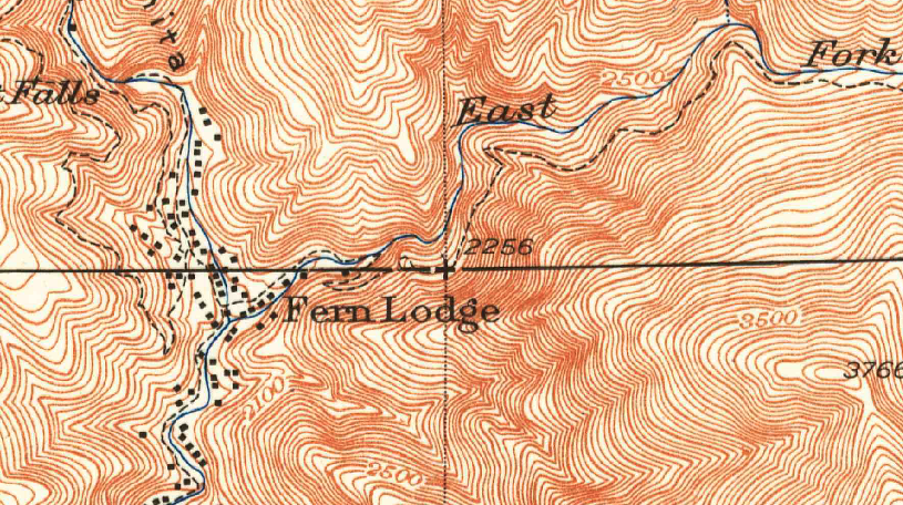
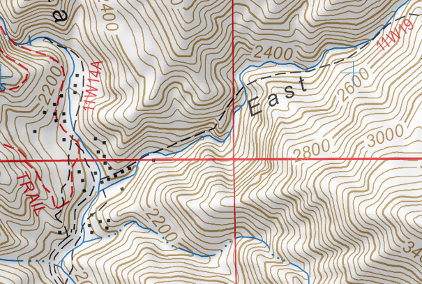
I tried this last summer and didn't make it very far. It's probably common knowledge on this board, but recent topos show the old trail up the East Fork of Santa Anita Canyon starting on the north side and going a good distance before crossing the creek. This way was unpassable when I tried, and I'm used to pushing my way through thickets of laurel sumac and poison oak. Recent research has led me to discover that older topos show the trail crossing the stream to the south side of the canyon very early on. So, it appears that the old trail may have been mostly on the south side rather than the north side.Uncle Rico wrote: explore the east fork of Santa Anita Canyon
1940 topo
2014 topo
-
bschmalz
- Posts: 41
- Joined: Fri Feb 08, 2013 1:39 pm
Working full time with occasional mandatory OT, combined with raising a 2 year old boy has limited my time on the trail, and more importantly, made it very hard to really stick to any plans I make.
Here are some of my long term goals for the San Gabriel Mountains:
- Day hike Islip Saddle to Baden Powell and back in winter.
- Three T's
- Mount Baldy big loop (Icehouse trailhead to bear canyon trail to baldy to baldy notch to icehouse saddle)
- San Gabriel thru hike from Wrightwood to Altadena, preferably in winter
- The Narrows
- Baldy Bowl winter ascent
- Lyell Fork in winter
- I have a crazy mountain biking loop that I want to do but I need to train in order to be able to do it. Here's the route: (Altadena > up the mt wilson toll road > down the trail to the red box fire road > up the fire road to red box > on the trail all the way around strawberry peak > onto a series of trails and fire roads to the top of mt lukens > down into la crescenta > up fire roads to the top of the verdugo mountains > down into glendale > up into the trails of the San Rafael Hills > back to Altadena. It's about 80 miles with like 12k elevation gain/loss. I'm hoping to do it in April if I can get in good enough shape by then.
-
walker

- Posts: 248
- Joined: Mon Apr 08, 2013 11:14 pm
Great topic, Rico.
I agree with Taco that the way you pick to get from Point A to Point B is often more interesting than the final destination. That said...
I'd love to make it to Fish Fork.
Climb Cucamonga directly from MF Lytle around Comanche.
Monrovia Peak, maybe bike and hike.
Visit the northern portion of the ANF.
Explore different old trails into and out of Pacoima Canyon.
And lots more.
I'd also like to explore the East Fork Santa Anita. I believe the older map shows the correct path of the trail. A little over a year ago I tried to find the trail. I saw some evidence of use tracks ascending where the first switchback should be, but I was not prepared to follow them across a bunch of dicey dirt slides above drop offs. I went further up canyon and ascended straight up the south side of the creek. I was able to locate a well preserved segment of the trail where it was blasted out of solid rock above some cliffs. I was able to follow it for a couple hundred yards, but it's high above the creek and involves stepping across or around some deteriorated gullies and debris slides with drastic drops into the canyon. I turned back at one such gap that was a bit too sketchy to try on my own. It was the kind of place where a person could easily get stuck between a rock and a hard place, so it's good to know your limits/comfort level, come back with a buddy or try an alternate route. However, really cool place to take a minute and imagine what it was like up there when the trail was still in use. I'd like to go back.
-
Uncle Rico
- Posts: 1484
- Joined: Thu Mar 20, 2008 7:48 pm
Good info about East Fork Santa Anita Bob and walker. If the old trail is obliterated and/or impassable in a good number of places, do you suppose the streambed is a viable alternative, or is that just foolishness? Additionally, do you happen to know whether it is or ever was possible to ascend the canyon all the way to the Spring trail camp site, or would that require AW/Taco skills? I note that Caltopo shows the trail leaving the canyon a short distance beyond its mouth and climbing steeply to Upper Clamshell Road.
By my questions you can tell I haven't visited there yet.
By my questions you can tell I haven't visited there yet.
-
SGBob
- Posts: 101
- Joined: Wed Jan 07, 2015 12:47 pm
Every map I've ever seen has the trail cut off to the Clamshell fire road. I don't think walking up the stream is possible for a number of reasons. First, it's a very small stream so it's choked with brush. There's no enough water to be lined with alders and such (at least where I was). Second, there's supposed to be some impassable falls a way up the canyon. There's this story from http://www.bigsantaanitacanyon.com/stories/cabin4.htm:Uncle Rico wrote: Good info about East Fork Santa Anita Bob and walker. If the old trail is obliterated and/or impassable in a good number of places, do you suppose the streambed is a viable alternative, or is that just foolishness? Additionally, do you happen to know whether it is or ever was possible to ascend the canyon all the way to the Spring trail camp site, or would that require AW/Taco skills? I note that Caltopo shows the trail leaving the canyon a short distance beyond its mouth and climbing steeply to Upper Clamshell Road.
By my questions you can tell I haven't visited there yet.
Code: Select all
During the 1950s, I was in my teens and I was very interested in the Canyon. My friends and I climbed just about every mountain and explored every trail. One trail I hope will be restored someday is the East Fork. At least as far as Adams Falls. Very few people in recent years have seen these beautiful Falls. Two Falls, side by side, from Spring Camp drop into a deep gorge.Also just found this video:
-
JerryN
- Posts: 200
- Joined: Sun Nov 11, 2012 4:01 pm
Ontario / Bighorn
Baldy / West Baldy
Baden Powell
in the snow
I don't have a very long time horizon so that is it for now
Baldy / West Baldy
Baden Powell
in the snow
I don't have a very long time horizon so that is it for now
-
BrownMtnBob

- Posts: 96
- Joined: Mon Oct 15, 2012 1:55 pm
Stanley Miller mine (camp at site)
Pacifico overnight
Little Iron
Condor Pk
Brown from the West ridge
Pacifico overnight
Little Iron
Condor Pk
Brown from the West ridge
-
Taco
- Snownado survivor
- Posts: 6213
- Joined: Thu Sep 27, 2007 4:35 pm
New goals include crossing the SG's from north to south, starting in the high desert and ending in the city. One of the routes over the western SG's finishes through Eaton Canyon, and the best western route ends down Cucamonga Canyon, so it's not just walking. Little bit o rope work in there.
-
tkane
- Posts: 12
- Joined: Mon Sep 02, 2013 1:11 pm
Browns Flat, Cow canyon- abandoned marijuana grow site needs cleaning up. Cascade canyon, Allison mine.