Page 1 of 1
Baldy loop hike 6-21-08
Posted: Sat Jun 21, 2008 9:37 pm
by AlanK
Once again, I parked at the Ice House Canyon lot and walked down to the Village. I took the Bear Flat Trail to the summit of Baldy and came back via the Ski Hut trail, closing the loop on the road. I was particularly interested in getting a good look at the Bear Flat area that burned a few weeks ago and I took mostly pictures of that area.
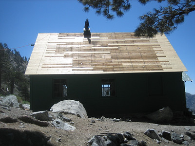
I also got a few pix of the progress on the Ski Hut roof. While at the Hut, I learned that a hiker had suffered an apparent heart attack and a fall, resulting in a head injury. Help was on the way by the time I arrived at the Hut and there were several people tending to the injured party. On the way down, a helicopter arrived, eventually carrying the victim away. There were several emergency trucks by the falls when I arrived there. I certainly hope that the guy is ok.
Regarding the hike: It was a hot day, with temperatures in the 70s early on and about 90 by the time I got back to the car. Down in the valleys, it was over 100. It was nice on top, though -- 70 and breezy. I was pleased to make it from the Village to the summit in a hair under 3 hours. I have not been hiking enough lately and that felt good!
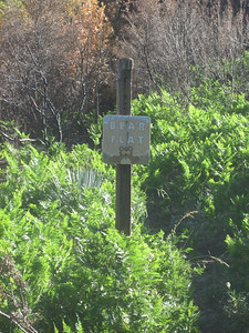
Someone said on another thread that the Bear Flats sign burned. No.

Ski Hut roof progress
 Pix
Pix
Re: Baldy loop hike 6-21-08
Posted: Sat Jun 21, 2008 9:57 pm
by HikeUp
AlanK wrote:Someone said on another thread that the Bear Flats sign burned. No.

All is ok now. Whew!

I somehow knew that your next hike was going to be this one.

Thanks for the pics. Good to see you're not slowing down despite the heat!
Re: Baldy loop hike 6-21-08
Posted: Sun Jun 22, 2008 8:15 am
by AlanK
HikeUp wrote:I somehow knew that your next hike was going to be this one.
I may be getting predictable, but I had to learn the truth about the sign!

Re: Baldy loop hike 6-21-08
Posted: Sun Jun 22, 2008 9:42 am
by FIGHT ON
The bear flat sign still being there is funny. Funny how the rumors of it being burned down grew from someone stating that they thought they heard someone say that they overheard a firefighters mothers brothers sisters son mention that to a friend. About a sign. And that changed to the cutie bear sign. And everybody believed it including me.
Nice to see what is still there.
I always believed that the Bear Flat trail started down at the visitors center or just down the Mt. Baldy road at the Bear Canyon Road intersection. Now I realize the actual trail starts a half a mile up at the end of the Bear Canyon Road. Maybe that's where the official starting point for Bear Flat to Baldy starts? I've been taking note of my cell phone clock at the Village Center White Gate and time myself from there. I always ask the hikers who pass me by what their best times are and what time they are aiming for that day but never thought to ask where they start their time from. Now I wonder. At a rate of around 2 mph, a half a mile would add up to about 15 minutes off or on a time. I thought it was six miles from the beginning of the trail but maybe that distance is measured from a half a mile up from the main road. Where does everybody start their time from? At the Mt Baldy Road or up at the end of the pavement where the dirt starts?
Re: Baldy loop hike 6-21-08
Posted: Sun Jun 22, 2008 9:49 am
by AlanK
I measure from the white gate at the Visitor Center to the summit sign. I measured 6.25 miles yesterday.
Re: Baldy loop hike 6-21-08
Posted: Sun Jun 22, 2008 9:57 am
by FIGHT ON
Cool. How do you come up with 6.25?
Re: Baldy loop hike 6-21-08
Posted: Sun Jun 22, 2008 10:02 am
by AlanK
FIGHT ON wrote:Cool. How do you come up with 6.25?
That was what my GPS said yesterday.
Re: Baldy loop hike 6-21-08
Posted: Sun Jun 22, 2008 10:17 am
by FIGHT ON
Wow. interesting, Do you find that your gps is often different than mileages stated on maps or in books? I can see how a gps would be reliable on a level surface for exact distances but as the terrain or slope increases and becomes more irregular it seems that the actual distance would be more than what the gps says. Maybe what you traveled is longer than 6.25. I wonder if the gps measures distances going vertically as accurately as horizontally. I realize nothing is going to be exact especially on a winding up and down trail. Just trying to figure out how it measures, if you know.
Re: Baldy loop hike 6-21-08
Posted: Sun Jun 22, 2008 2:27 pm
by AlanK
FIGHT ON wrote:Wow. interesting, Do you find that your gps is often different than mileages stated on maps or in books? I can see how a gps would be reliable on a level surface for exact distances but as the terrain or slope increases and becomes more irregular it seems that the actual distance would be more than what the gps says. Maybe what you traveled is longer than 6.25. I wonder if the gps measures distances going vertically as accurately as horizontally. I realize nothing is going to be exact especially on a winding up and down trail. Just trying to figure out how it measures, if you know.
I believe that the GPS calculated horizontal difference, but it makes almost no difference for hiking. If you are hiking on a 10% grade (528' per mile elevation gain) the difference between the horizontal distance and the distance along the slope is 0.5%. GPS is not that accurate.
GPS figures locations to within a couple of meters and calculates the distance between subsequent points (which are typically on the order of 10 seconds apart). The total calculated distance shaves off corners on sharp switchbacks, etc.
I have measured the Bear Flat trail several times and always gotten something around 6.25 miles in summer. (In the winter, the trail is irrelevant in many places.)
Re: Baldy loop hike 6-21-08
Posted: Sun Jun 22, 2008 3:22 pm
by AlanK
Mark I posted the following on the
Whitney Portal Store Message Board.
This may be a little off topic but I know there are more than a few Mt. Baldy fans on this board.
A 58 year old hiker, Joe Dare of Bellflower, suffered a heart attack while hiking the Ski Hut trail on Mt. Baldy. He lost consciousness and fell approximately 50 feet into the stream bed below the trail. This happened right in front of the Sierra Club Ski Hut and several of the members inside the hut, as well as other hikers nearby, responded to the victim, helping stabilize him until he was airlifted out. I don't know the current condition of Mr. Dare but I hope he is doing well and can recover completely. I do know that everyone involved tried to give this the best outcome possible, especially the San Bernardino Sheriff Rescue team, who did a professional and efficient rescue of Mr. Dare. Hats off to SAR teams everywhere who risk their lives to save the lives of injured hikers and climbers who otherwise wouldn't stand a chance.
Mark's pictures and
video.
Re: Baldy loop hike 6-21-08
Posted: Mon Jun 23, 2008 8:40 am
by calicokid
Thanks for the report and pix. I am glad those pine trees along the trail still there given there aren't many on that long steep part.


