
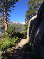
I'm looking at a few CC hikes. Has anyone gone from the saddle (actually past Icehouse saddle on the way to Cucamonga peak) down Cucamonga canyon? Can you advise on what I should expect please.
M
Cucamonga Canyon
-
mattmaxon

- Posts: 1137
- Joined: Mon Mar 24, 2008 12:48 pm
I believe you're gonna need a rope.
old maps show a trail to the falls, i forget if the trail goes above the falls or to the base of the falls
i hesitate to call the trail a trail as it is probably more of a line on a map than a trail
I have never been in there but have looked into going down there, it is also my understanding there are several aircraft wrecks in there.
-
Gozerian138
- Posts: 39
- Joined: Wed Feb 24, 2010 10:17 am
Was this hike down Cucamonga Canyon ever attempted by Migolito? I have long been interested in exploring this canyon. Someday when I have time perhaps.. However I would love to see a trip report if it has been done recently.
Here is the only information that I found on Cucamonga Canyon. Looks like an adventure
http://www.dankat.com/advents/cucamg.htm
http://www.dankat.com/advents/uprcuc.htm
Here is the only information that I found on Cucamonga Canyon. Looks like an adventure
http://www.dankat.com/advents/cucamg.htm
http://www.dankat.com/advents/uprcuc.htm
-
AW~

- Posts: 2127
- Joined: Mon Oct 01, 2007 12:00 pm
There was a tr filed by West Valley SAR 6/22/09

Some images on the internet as well....4th falls aka main falls("upper")...Team 2 began their assignment in Cucamonga Canyon around midnight, entering the canyon from the location of the last set of identified prints and negotiating their way down a moderately steep slope. Concentrating on likely track traps, Team 2 located a descent print within 45 minutes. Finding the print, a surprising stroke of luck in the dark in the wide canyon, seemed to confirm that the subject had indeed left the trail in daylight and gone down canyon, perhaps thinking he was cutting the switchbacks to catch up with his companions. Confirming the find with the CP, Team 2 set out looking for more prints or sign as they proceeded down canyon. They would find nothing for 6 hours.
Picking their way down the canyon, Team 2 saw evidence of recent travel in the canyon but no prints and nothing that could definitively be attributed to the subject. The wide rocky canyon narrowed, and a stream eventually appeared. Travel was slow, steep in many areas with poor footing. The biggest concern was the possibility, assuming the subject had indeed continued down the canyon, that Team 2 would simply miss a sleeping or unconscious subject in the dark canyon. Attempts to locate the subject by voice and whistle were made continuously as the team proceeded. The team made hourly contact with CP, reporting position by UTM but no success in locating any sign of the subject. Around 0530, after covering a little over a mile, the team called a stop to rest and await daylight. A brief nap on the rocks and the team continued at dawn, lamps no longer necessary. Amazingly, within 20 minutes Team 2 had located another set of prints, very distinct in damp sand near the stream on the canyon floor. This encouraging sign seemed to indicate that the subject was down there, still ahead of Team 2 and proceeding toward the falls about 2 miles below the saddle. It was agreed with CP that Team 2 would proceed to the falls, which would, it was assumed, prevent the subject from proceeding any further.
At this point the canyon had leveled but was becoming more difficult to negotiate. The stream was larger, and the canyon floor was overgrown with brush following recent fires. Fallen trees created foot hazards and made for slow travel, and repeated stream crossings were necessary. With daylight, 40 King was soon operating and, after briefing at Cow Canyon Saddle was searching the canyon above the falls and ahead of the still advancing Team 2. Communicating on the same frequency as CP and Team 2, 40 king announced around 0830 that they had located a subject just 1/4 mile down canyon from Team 2. Within 30 minutes Team 2 had made contact and confirmed the subject's identity. He was uninjured and in good spirits, having ended his trek down the canyon the prior evening and camping not far from where he was located that morning. Wet from the stream he had attempted a fire, with little success, and then managed some sleep through the night.
Fortunately for both the subject and Team 2, 40 King reported a possible LZ just 100 feet up the slope from the subject. After refueling, the helicopter returned to extract first the subject and then Team 2 from a ridge above the falls back to Cow Canyon. Transport down the hill to CP at Baldy Fire, and the rescue was concluded. The subject was taken by friends to join his parents, and Team 2 headed home for some sleep!

-
Taco

- Snownado survivor
- Posts: 6230
- Joined: Thu Sep 27, 2007 4:35 pm
Yep, it's a canyoneering kinda canyon. Haven't done it myself either, except for the lower section with one rapp, a couple slides and jumps, and the trail to the city.
-
goldentrout
- Posts: 1
- Joined: Sat Nov 26, 2011 11:26 pm
Hi All,
I was on my way up the cucamonga truck tail and as I was walking away from the car a resident drove up and stopped me. He said that pretty soon the fire road will be prohibited to the public. He said some guy owns all the land behind those McMansions and that if you look up at the top of the hill and see the graded flat top hill, the landowner was trying to build a house on top of the hill.
The guy also said at the water district and city are behind the closure of the land. Now my question is, does anyone have further information about this? why is it not in the newspapers?
Also who is the person that owns all land back there?
Thank you!
GT
-
hvydrt
- Posts: 494
- Joined: Thu Sep 27, 2007 8:18 pm
It looks like 4 pads have been graded on top of PK 3742. On the USFS 7.5' quad, section 16 appears to be outside of the national forest boundary. I am not sure how you find out who owns the land, but if its private property, there probably nothing you can do. The home owners on Skyline Drive have signs up saying you will be cited for parking on that street.
-
AW~
- Posts: 2127
- Joined: Mon Oct 01, 2007 12:00 pm
Sounds like the typical "1%" landowner....only access is through the courts....in the La Vina case, it only took what? 6 years and its still unresolved?
-
1redforester
- Posts: 6
- Joined: Sun Jun 19, 2011 12:42 am
I was wondering what the grading was for and now I know. I wonder how they plan to get utilites up there? I don't believe the FS will alow them to go through the forest to get up there. Anyway it's an ugly scar and an even uglier house will probably end up there. Good luck the next time we have a Santa Ana driven fire go through there.
-
atomicoyote

- Posts: 173
- Joined: Fri Dec 24, 2010 2:16 pm
You could search the property records at a local San Bernardino County office in the area (microfilm or similar), or if you know a real estate agent/broker they could get you the info really quickly. If that is private property, then you'd want to find out if there's a public right-of-way easement for the fire road; the NFS or a local agency (especially fire dept) might have requried it as part of a development plan so they could have access in case of fire, mudslide, or other emergency in the area, and/or to allow public access to public lands father up the canyon. If that was the case the govt agency would probably gate the road to prohibit vehicle traffic, but leave it accessable/open for hiking/walking (maybe MTB-ing too) as long as it didn't become a problem (trash, vandalism, abandoned cars, body dumps  , etc). Since you mention it, you might check with the admin offices of the local water district or area fire dept to see if they have any leads on it.
Edit: Forgot the obvious, but if its in the City of Rancho Cucamonga, check the city website under either the Planning or Building Dept and see if there's anything. If its a significant project it'll usually be publicized there. Best bet is usually the Planning Dept, as that's where major & new developments that tear up land get processed and environmental review docs documents get posted.
I was involved in a similar situation back in the early 1990s in northern California where a rancher tried to exert control over a leased piece of land, but a R-O-W in the lease allowed public access as long as folks stayed on the dirt road.
-
1redforester
- Posts: 6
- Joined: Sun Jun 19, 2011 12:42 am
I think this may be outside of the RC city limits and on county or SRA (state responsability area) land. I would try San Bernardino County for info although this also maybe under the sphere of influence for Rancho. Either way the road leads to public land and should not be closed off for access. Although with the state of things someone with deep pockets may own this and access could be closed. Remember "public lands for the people not from the people." I think the SBNF would like all of the front country closed in this area. I was harrased by the SB County Sheriff once for being in Deer Canyon after telling him I was LA County Fire and producing I.D. he still searched my truck. I guess the bad apples have once again screwed the rest of us. To bad as these are some neat canyons to explore.
-
HikeEnthusiast55
- Posts: 30
- Joined: Tue Jan 28, 2014 4:12 pm
http://www.dailybulletin.com/government ... cost-70000
WHY? It's such a great place.
The government should F off from the Cucamonga Canyon, an amazing location that ONLY DUE TO WEALTH RESIDENTS COMPLAINING ABOUT THE PEASANTS USING THEIR LAND has been shut down.
Now the government's controlling claws are surrounding it out of "protection".
What the hell?
Who else loves this place and is pissed off too?
-
T McPherson
- Posts: 17
- Joined: Thu Aug 25, 2011 10:30 am
If they could keep out the destructive elements of society, it would not come to this, here or elsewhere. Have you seen what damage has been done there lately? It really stinks, wealthy people, water sources, wildlife concerns, fire danger or not.
-
HikeEnthusiast55
- Posts: 30
- Joined: Tue Jan 28, 2014 4:12 pm
most of it is pretty much untainted. the vast majority of the area they block off is pristine.T McPherson wrote: If they could keep out the destructive elements of society, it would not come to this, here or elsewhere. Have you seen what damage has been done there lately? It really stinks, wealthy people, water sources, wildlife concerns, fire danger or not.
IMO it's just an excuse to gain control and do the bidding of the rich home-owners who feel privileged to be exclusive and away from the visitors.
They consider the lands to be their personal estates
-
AW~
- Posts: 2127
- Joined: Mon Oct 01, 2007 12:00 pm
So here is basically the final decision on parking...
http://www.dailybulletin.com/lifestyle/ ... nga-canyon
26 Total public parking spaces
Cost: $15-$25 per day depending on the season
Parking time: 7am to 6pm...towed after that.
Parking should be reserved in advance....up to 3 months in advance. Otherwise the permit is to be obtained by going to a certain city library.

-
dima

- Posts: 1941
- Joined: Wed Feb 12, 2014 1:35 am
- Location: Los Angeles
This is only mildly on-topic, but why is peak hiking season "May through September"? It's hot and the waterfalls are dry-er then.
-
AW~
- Posts: 2127
- Joined: Mon Oct 01, 2007 12:00 pm
Theres a fire burning near the Etiwanda preserve
http://inciweb.nwcg.gov/incident/3848/
That should just about ensure that the canyon is closed forever? Because closing it stops forest fires
Source:CalFire
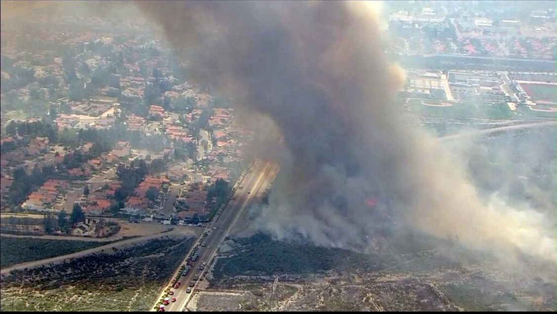
http://inciweb.nwcg.gov/incident/3848/
That should just about ensure that the canyon is closed forever? Because closing it stops forest fires
Source:CalFire
-
HikeEnthusiast55
- Posts: 30
- Joined: Tue Jan 28, 2014 4:12 pm
Is cucamonga canyon open yet at all or is it still closed with a big flashing sign??
34° 9'58.36"N 117°37'47.12"W

34° 9'58.36"N 117°37'47.12"W
-
AW~
- Posts: 2127
- Joined: Mon Oct 01, 2007 12:00 pm
It should be open.....although there still is a closure in effect for lower Cucamonga canyon/Sapphire Falls, elevation 2680 through 2220.
The other thing is that the forest website lists the approach trail road 1N34/San Sevaine/Big Tree as closed per an order 2/27/14. Ive always taken that to mean it cant be driven but its listed as a closure so it might be necessary to be bequeathed by the forest service to hike that road.
Edit: the parking website says to allow for 3-5 business days to receive the parking permit. Its not as simple as pay and print.
I'll note that "Parking will be strictly enforced between the hours of 7 a.m. - 6 p.m." may not mean parking wont be enforced after 6pm. They had earlier said the parking lot was closed after 6pm.PARKING IN CUCAMONGA CANYON - Effective 6/9/14
Reservations for parking on both sides of Almond Street between Sapphire St. and Henry St. can be made online at www.ParkRancho.com or by calling (909) 303-6030. All visitors MUST reserve a parking space. There will be NO charge for Rancho Cucamonga residents with proof of residency. Reservations are still required.
Need computer access to reserve a parking space? Public computers are available for use at the Archibald Library during business hours.
Parking will be strictly enforced between the hours of 7 a.m. - 6 p.m. Sunday - Saturday. Violators are subject to towing.
Parking rates are as follows:
Peak Season (May 1 - September 30): Monday-Thursday $20/day and Friday-Sunday $25/day
Off-Peak Season (October 1 - April 30): Monday-Thursday $15/day and Friday-Sunday $20/day
For questions regarding reserved parking in Cucamonga Canyon, please contact Tiffany Cooper at (909) 477-2740 x . 4029.
The other thing is that the forest website lists the approach trail road 1N34/San Sevaine/Big Tree as closed per an order 2/27/14. Ive always taken that to mean it cant be driven but its listed as a closure so it might be necessary to be bequeathed by the forest service to hike that road.
Edit: the parking website says to allow for 3-5 business days to receive the parking permit. Its not as simple as pay and print.
-
Bobcat22
- Posts: 10
- Joined: Fri May 02, 2014 6:10 pm
I have always wondered about Cucamonga canyon, how is it in general? I have looked down there from the top of Bighorn peak and Ontario peak and it looks interesting. However I never read any trails in the area except for the close Sapphire Falls trail.
Is it worth the 15 dollar parking permit? Or is it just best to keep driving?
Is it worth the 15 dollar parking permit?
-
HikeEnthusiast55
- Posts: 30
- Joined: Tue Jan 28, 2014 4:12 pm
It's an amazing locationBobcat22 wrote: I have always wondered about Cucamonga canyon, how is it in general? I have looked down there from the top of Bighorn peak and Ontario peak and it looks interesting. However I never read any trails in the area except for the close Sapphire Falls trail.
Is it worth the 15 dollar parking permit?
honestly just hike there from barret stoddard. it isn't that hard
you'll enjoy it
-
Taco
- Snownado survivor
- Posts: 6230
- Joined: Thu Sep 27, 2007 4:35 pm
Do you mean hiking down Cucamonga Canyon from Icehouse Saddle? If so, Check out Chris's site here: http://www.dankat.com/advents/content.htm
Scroll down a bit to the Icehouse Canyon section and you'll see info for Cucamonga Canyon divided into segments.
Scroll down a bit to the Icehouse Canyon section and you'll see info for Cucamonga Canyon divided into segments.
-
Bobcat22
- Posts: 10
- Joined: Fri May 02, 2014 6:10 pm
I had not thought from Icehouse canyon but that may not be a bad idea in fact. Thanks for the link!
I'll check out the Stoddard route as well.
I'll check out the Stoddard route as well.
-
Migolito
- Posts: 31
- Joined: Thu Jun 24, 2010 10:14 pm
Does anyone have any info on hiking down Cucamonga canyon from the saddle past the top of Ice House Canyon? Who has done it, what should I expect, etc.
-
walker

- Posts: 248
- Joined: Mon Apr 08, 2013 11:14 pm
I haven't been in there, but according to Chris Brennan:
"It is a strenuous, two day adventure hike with some spectacular scenery and several challenging rappels."
He's got three entries, upper, middle and lower cucamonga:
http://www.dankat.com/advents/uprcuc.htm
http://www.dankat.com/advents/cucamg.htm
http://www.dankat.com/advents/lowcuc.htm
"It is a strenuous, two day adventure hike with some spectacular scenery and several challenging rappels."
He's got three entries, upper, middle and lower cucamonga:
http://www.dankat.com/advents/uprcuc.htm
http://www.dankat.com/advents/cucamg.htm
http://www.dankat.com/advents/lowcuc.htm
-
Taco
- Snownado survivor
- Posts: 6230
- Joined: Thu Sep 27, 2007 4:35 pm
I've only completed Lower, and would like to do the entire thing at some point. It looks pretty. Lower is dirty, crowded, and tagged up.
-
CrazyHermit

- Posts: 343
- Joined: Mon Sep 07, 2015 1:03 pm
Cucamonga Canyon is closed until April of 2019. There's a small mine in the lower part.
Hopefully they'll clean up the area near Sapphire Falls by then.
Forest Order
Hopefully they'll clean up the area near Sapphire Falls by then.
Forest Order