Page 1 of 1
Stockton Flats/Lytle Creek Questions
Posted: Fri Oct 18, 2013 7:02 pm
by Hikin_Jim
So, I've eyeballed the
Stockton Flats/N Fork Lytle Creek area for some time. Never have gotten over there, go figure (except for the Middle Fork of Lytle Creek which is great).
So, anything worthwhile for a mere hiker? (I don't do Taco style mountain death climbs).

How far up the N Fork can I drive in a standard passenger car?
Are any of those trail camps I've marked on the map linked to above worth anything? (Piute, Coldwater, and Big Horn)
What's the road up the backside to Baldy Notch like? Is that a worthwhile hike?
HJ
Re: Stockton Flats/Lytle Creek Questions
Posted: Fri Oct 18, 2013 10:16 pm
by HikeUp
3 and a half years ago (how's that for current?), I was able to drive in my Honda CRV to the point where 3N06 crosses Lytle Creek to get to Stockton Flat with no issues. Couldn't go any further because the gate was closed at that location for some reason.
Location of gate in super zoom satelite mode!...
http://caltopo.com/map.html#ll=34.29925 ... z=20&b=sat
When you going?
One cross country easy scramble I did in the area was what I call
Chalk Canyon which is the canyon on the west side of what the Sierra Club HPS calls Chalk Peak or something.
Re: Stockton Flats/Lytle Creek Questions
Posted: Sat Oct 19, 2013 1:16 pm
by tarol
Jim - I've driven up there dozens of times. The road is very very rocky and there are some good ruts. I personally wouldn't take a regular passenger car up it. Last time I took a personal rig up it, a 4x4 Jeep Compass, we ran into lots of spots where I had to move rocks. Last time I drove it in a FS rig, in August, I was in a 4x4 Ranger and scraped bottom a couple of times :p
I've camped in Paiute Canyon at the first site - there is a seasonal waterfall there and the scenery is nice. Again, the road is in pretty bad shape.
Coldwater Canyon is closed to vehicles right now, but might make for a nice hike. Gobbler's Knob up to Blue Ridge along the PCT is another option.
If you go now, expect lots of hunters - wear orange.
http://www.tarol.com/coldwater_paiute
Re: Stockton Flats/Lytle Creek Questions
Posted: Sat Oct 19, 2013 11:16 pm
by Taco
Not a whole lot. Quiet when not hunting season. Good for winter climbing stuff, that's about it.
Re: Stockton Flats/Lytle Creek Questions
Posted: Sun Oct 20, 2013 9:00 pm
by Hikin_Jim
Well, um, yesterday actually.

But I'd like to go up again. The Coldwater Canyon area in particular looks worthy of further exploration.
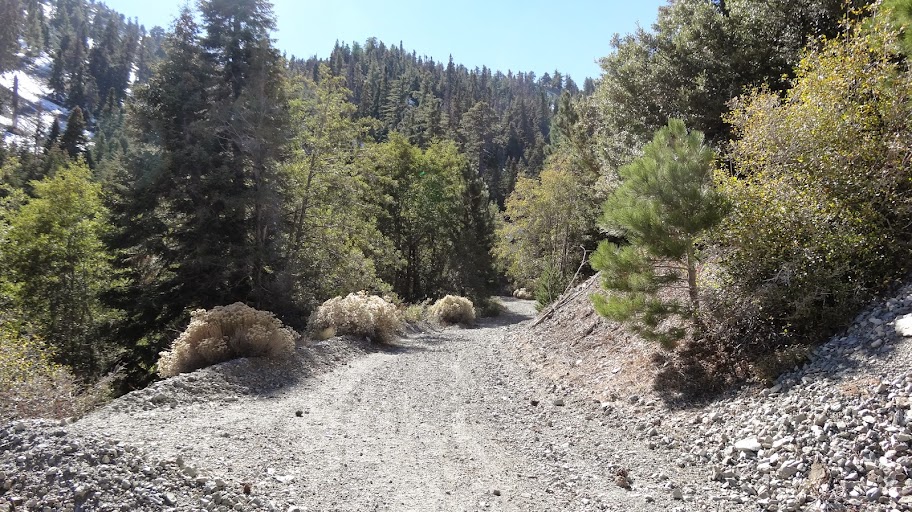
The road (3N06) is in decent shape until you get to the creek crossing that HikeUp mentions. The crossing itself is a little sketchy in a passenger car, but with care and picking a good line, my Accord made it. From the crossing to the "trailhead" (the locked gate that prevents further progress by the public) is definitely sketchy for a passenger car. I had to get out of the car and "rearrange the road". I scraped my sides a couple of times on brush trying to maneuver around rocks. Doable, but not recommended.
Lotsa hunters around the flats, but only two hikers on the road to the notch. The hike itself is nice, but nothing to write home about. Middle Fork is a lot more scenic. The section through one of the branches of Coldwater Canyon is actually kind of nice (for a road walk).
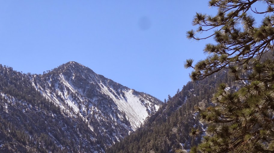
Nice views of what I
think is Telegraph Peak.
Most interesting was this:
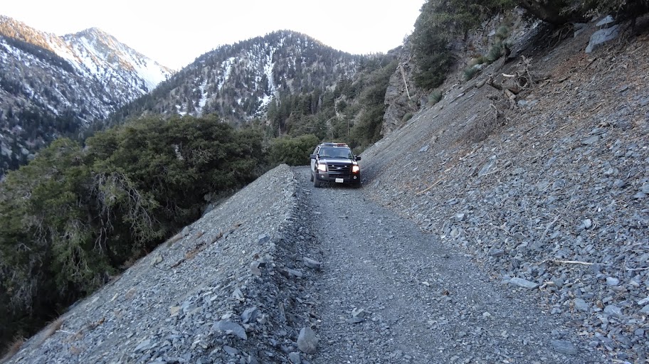
That's an LA County Sheriff's vehicle. Now of course the Lytle Creek area is entirely in
San Bernardino County. So what's an
LA sheriff doing there? Dunno. And of course it's USFS jurisdiction, not really county. Kinda weird.
Road's in good shape though.
HJ
Re: Stockton Flats/Lytle Creek Questions
Posted: Sun Oct 20, 2013 9:16 pm
by Hikin_Jim
Interesting thing about
Coldwater Canyon is that the topo map shows the road (3N06A) turning into a trail part way up the canyon. From above where I was on the main branch of 3N06, it was clear that it was a road the whole way although there might be something blocking it part way up the canyon.
The other interesting thing is that the road very clearly goes past Coldwater Camp. Just toggle to Satellite view, zoom in, and you can see it very clearly climbing out of the canyon bottom and switch backing up the west ridge. Or look at the below photo.
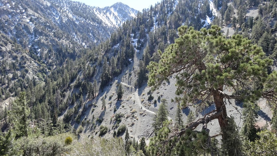
Now why would anyone go to the trouble of building a road up the side of the canyon? Maybe an old mine or something? Couldn't see any obvious tailings.
HJ
Re: Stockton Flats/Lytle Creek Questions
Posted: Sun Oct 20, 2013 9:34 pm
by HikeUp
Cool that you made it as far as you did in your Accord. Look for Sean's recent TR regarding Coldwater Canyon for more info about the area in your last pic.
99.99% sure that is Telegraph in your pic. Nice to see snow.
Re: Stockton Flats/Lytle Creek Questions
Posted: Sun Oct 20, 2013 11:09 pm
by Taco
yup, NW face of Telegraph.
The road is for the DWA's potfarm. If you go in there, you get ambushed by fat ninjas who think they're SF.
Re: Stockton Flats/Lytle Creek Questions
Posted: Mon Oct 21, 2013 7:57 am
by Hikin_Jim
Sounds like it's pretty unanimous that the peak I took a pic of is Telegraph. It sure looked like it based on the topo map, but I've made those calls wrong before. Sometimes it's hard to tell when looking obliquely at a distance.
Sean's post has nearly the same photo (and Sean says it's Tele as well).
Sean's post asks the same question I did about that old road. Looks like the answer can be found on
Tom Chester's page about Stockton Flats.
This road was built by the Hocumac Company to service the 14 gold mines owned by them, and replaced a wagon road constructed in 1883 from Lytle Creek to Baldy Notch along Coldwater Canyon to reach the Banks (Gold) Mine. The new road was a vast improvement - wagons had to be lowered by winch on one part of the [old] wagon road. These roads were the only access to Baldy Notch at the time.
If the road in my photo is really the old road from 1883, then it's in amazingly good shape. How it got the rest of the way to Baldy Notch is beyond me, since it's in some seriously steep terrain, but that be just what they did (go through the steep terrain), given that they used a winch on part of the route. Crazy stuff that those old miners used to do!
I may have gotten amazingly lucky -- all of the gates were open. Chester's page says they lock the gates in the evening. We didn't get back to the car until 1830 or so.

HJ
Re: Stockton Flats/Lytle Creek Questions
Posted: Mon Oct 21, 2013 7:59 am
by Hikin_Jim
HikeUp wrote: Cool that you made it as far as you did in your Accord.
Maybe not the brightest move, but we made it.
Getting to the junction of 3N33 and 3N06 isn't bad, but crossing the creek and going up to the campground area is a little rough.
HJ