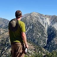
I haven't posted in a while, my apologies, I have been hiking! Today I hiked in Falling Rock Canyon for the fourth time. The first time was a straight descent of the canyon which will not be forgotten due to all the thorny plants. The next two were descents down the ridge to Sugarloaf. This would be my first time ascending the canyon.
THe route to Fallling Rock is very evident as it is the first opening as you hike up IHC but if you want some more help then cross the creek at the first switchback and head upstream until you get to the drainage. If you want to bypass the first waterfall continue up the left side of the drainage on loose rocks towards a small grove of trees. From there you can contour back into the canyon atop the waterfall. I hadn't realized how steep the initial climb of FR was and it was much more enjoyable as a climb up then coming down. You have more opportunity to stick to solid rock on the ascent without it slowing you down.
The route up to the ridge should follow the gully as much as possible otherwise you're on really loose crap that will take an extra step to move anywhere. On the way down the loose crap is what allows you to have a scree slide. The point to leave the canyon is pretty evident with a duck and a gully where you can just about make out the apex of the ridge. If you get to the second waterfall you have gone too far.
From here you have a loose use trail to take up to Sugarloaf that heads north and then west. I'm not a big fan of this use trail as its loose and narrow. I made good timing to Sugarload in just about 1:20. From there back to the saddle and the steep climb up to Ontario. This route is much easier to follow then on the way down where the last connector to the saddle is not very evident when you make your way through the rock garden. This section also allows you to play the manzanita maze game which is actually quite fun and the only penalty is scratched up legs. The steep parts all have good use trail and occur in the beginning. They are mainly on loose dirt so it really gives you an excellent work out. On the final section the steepness starts to taper off and you are on a broad ridge with lots of unpleasant plants to wade through. Try to stick to the right side as there are more trees in that area and less vegetation. Once you're on the trail you're effectively on Ontario, can't beat that. I reached the top of Ontario in 3 hours.
The views were a bit murky as there was still some marine layer lurking about. From there I had to knock off False Ontario which I had never climbed so I stuck to the ridge. On top FO there is a rock ring but I couldn't find the old register that I heard had been on there. From there down to the trail and on to the good use trail over to Bighorn. I was happy with my strength as I powered up Bighorn without having to stop. From there I started descending the ridge and then turned off in a NE direction down the mellow ridge that almost deposits you at the IHC saddle. This section starts to steepen and you get to play the manzanita maze game once again. Stick to the west or left side near the trees to avoid the worst of this scourge. You should hit the Ontario trail about 100 yards west of the saddle and the rest is history. The only postscript was that the IHC trail was pretty quiet compared to a usual weekend day but that also has to do with the time which was mid-afternoon and it gets packed in the morning. The whole hike took 5:45 was about nine-ten miles with about 4,200 feet elevation gain.
Falling Rock to Sugarloaf, Ontario, and Bighorn
-
mcphersonm80

- Posts: 243
- Joined: Mon Aug 23, 2010 11:46 am
Great report, David. Did that route a few weeks back, lots of fun. 
Since you've descended the canyon a couple times, maybe you'd know... would it be possible to skip the exit up to Sugarloaf and ascend the canyon the entire way up to False Ontario without exceeding Class 3 (in other words, how high is that second waterfall)? I really enjoyed that bottom portion and next time up, want to give that a shot.
Since you've descended the canyon a couple times, maybe you'd know... would it be possible to skip the exit up to Sugarloaf and ascend the canyon the entire way up to False Ontario without exceeding Class 3 (in other words, how high is that second waterfall)? I really enjoyed that bottom portion and next time up, want to give that a shot.
-
David R
- OG of the SG
- Posts: 633
- Joined: Sun Jun 12, 2011 10:28 pm
There are two additional waterfalls on the way up Falling Rock. Both are easily bypassed with minimal scrambling. From my recollection,if you are heading up, the first waterfall could be bypassed to the right via a scree slope. The second waterfall bypass was to the left. When I went the top waterfall was dry. The main challenge as you get higher up was the quantity of prickly plants that grow on the canyon floor.
-
Sean

- Cucamonga
- Posts: 4266
- Joined: Wed Jul 27, 2011 12:32 pm
Thanks for the report. I'm planning to do this within the next couple weeks. Any pictures of the waterfalls?
