
Topographic Esoterica
-
Uncle Rico

- Posts: 1484
- Joined: Thu Mar 20, 2008 7:48 pm
Did the 3 T's trail on Sunday for the first time. Discovered that the "peak" immediately south of Telegraph (what I initially thought was Telegraph) is apparently not an independently named and recognized peak at all. It just shows on topos as point "8923." So if this point is not a "peak," what is it? I guess the broader question is when does a "peak" become a peak? Using this point/summit/sub-peak/whatever as an example, it appears to my untrained eye that it has significant topographic prominence and isolation to warrant peak status, but I guess the peak gods disagree. Enlighten me topography geeks.
-
RichardK

- Posts: 727
- Joined: Sun Sep 30, 2007 12:33 pm
It is a topic of discussion among climbers as to what is a peak and what is a bump on a ridgeline. I don't know if Peak 8923 qualifies for independent status under whatever rules they are using. If it is considered separate, then the geographic naming board would have to approve a name, a process that could take years if ever.
-
Taco

- Snownado survivor
- Posts: 6193
- Joined: Thu Sep 27, 2007 4:35 pm
You mean the south summit of Telegraph? It's still Telegraph, just that the point to the north is higher by x amount of feet. The south summit has better views anyway, and has better routes up to it in winter.
-
Hikin_Jim

- Posts: 4688
- Joined: Thu Sep 27, 2007 9:04 pm
There's no standard definition of a peak, but you'll hear talk about prominence and isolation.
Prominence refers to the amount a high point rises above the nearest saddle that connects it to a higher point. In the case of point 8923, the saddle between the the two high points is approximately elevation 8820, which would give point 8923 a prominence of 103 vertical feet -- not much prominence in other words. There is no standard figure that automatically qualifies a high point as a peak, but most people would not call point 8923 an indpendent peak. On the other hand, let's take a look at Telegraph Peak (8985'). The next highest point to Telegraph Peak is Mount Harwood (9552'). The saddle that connects them is Baldy Notch (7802'), which means that Telegraph Peak has a prominence of 1,183' -- more than 1,000' vertical feet. Most people would consider Telegraph Peak an independent peak.
Isolation refers to how far apart two high points are. If you have a long ridge with a high point at either end, both high points might be considered peaks simply because they are so distant from one another even if there weren't much difference in elevation between the two high points. Put those same two high points right next to each other and probably only the higher of the two would get a name.
The naming of peaks being a human enterprise, there all sorts of quirks and exceptions.
HJ
-
Uncle Rico
- Posts: 1484
- Joined: Thu Mar 20, 2008 7:48 pm
Thanks for the insight boys. I guess it makes sense to call it the south summit of Telegraph ala Taco, but I'm just surprised that it isn't referenced that way on anything I looked at. It's just another number on a map (or not even identified) which isn't necessarily a bad thing I suppose. It just seems to me based purely upon looking at topos that giving a feature peak status is somewhat of an arbitrary endeavor. For example, the ridge running north-east from Cucamonga appears to have a couple of identifiable points above 8000, but the only one I am aware of other that Cucamonga worthy of identification is Etiwanda.
So who ultimately makes the call? Is it a bunch of USGS functionaries sitting around a conference room table in their short sleeves and ties pouring over maps and arguing about prominence and isolation or is there another method? I've never really thought much about it before now.
So who ultimately makes the call? Is it a bunch of USGS functionaries sitting around a conference room table in their short sleeves and ties pouring over maps and arguing about prominence and isolation or is there another method? I've never really thought much about it before now.
-
Hikin_Jim
- Posts: 4688
- Joined: Thu Sep 27, 2007 9:04 pm
Change "somewhat of" to "completely" and I think you're closer to the mark.Uncle Rico wrote: ...giving a feature peak status is somewhat of an arbitrary endeavor.
There is a process by which one can submit names to the USGS, but it appears to be long and involved. There are of course many peaks, such as Etiwanda, which have no official name in the eyes of the USGS but whose names are recognizable by locals.
I can think of half a dozen just off the top of my head:
Etiwanda
Goodykoontz
Deception
Akawie (formerly referred to as Buckhorn Pk)
Middle Hawkins
Gobbler's Knob
These are all peaks with "local" names but no official name.
HJ
-
AW~

- Posts: 2110
- Joined: Mon Oct 01, 2007 12:00 pm
Which of these are officially named peaks? I would give the source of the picture, but then you would know the answer.
-
PackerGreg

- Posts: 623
- Joined: Sat Sep 12, 2009 9:31 pm
If Telegraph has two summits, is the connecting feature a ridge? If so, and the south summit were to gain peak/mount status, would the ridge necessarily become a saddle? And if the ridge were to become a saddle, would it necessarily inherit the name of the taller peak?
-
RichardK
- Posts: 727
- Joined: Sun Sep 30, 2007 12:33 pm
Near Mt. Whitney, these come to mind:Hikin_Jim wrote: There are of course many peaks, such as Etiwanda, which have no official name in the eyes of the USGS but whose names are recognizable by locals. HJ
Mount Carl Heller - the China Lake Mountain Rescue Group petitioned to have an unnamed peak near Mt. Whitney named after one of their deceased founding members. It was denied.
Mount Randy Morgenson - Randy Morgenson was a back country ranger and the subject of the book The Last Season. He died while patrolling in the winter. There is an informal effort to name a peak after him.
-
Uncle Rico
- Posts: 1484
- Joined: Thu Mar 20, 2008 7:48 pm
Me not know Canyon Man and I'm not about to embarrass myself anymore than I already do by guessing and demonstrating my complete ignorance. So help a brother out would ya?AW wrote: Which of these are officially named peaks? I would give the source of the picture, but then you would know the answer.
-
AW~
- Posts: 2110
- Joined: Mon Oct 01, 2007 12:00 pm
I lost a reply post 
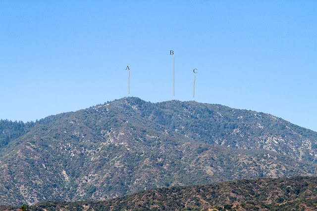
Anyway, A is Rankin Peak 5291, B is not even a peak according to the topo, and C is Monrovia Peak 5409.
http://www.gemcityimages.com/2012/07/po ... -peak.html
I have no idea why Rankin is a named peak with only 100 ft of prominence.

Also note Clamshell Peak 4389 and Mack Peak 4364
Anyway, A is Rankin Peak 5291, B is not even a peak according to the topo, and C is Monrovia Peak 5409.
http://www.gemcityimages.com/2012/07/po ... -peak.html
I have no idea why Rankin is a named peak with only 100 ft of prominence.
Also note Clamshell Peak 4389 and Mack Peak 4364
-
Hikin_Jim
- Posts: 4688
- Joined: Thu Sep 27, 2007 9:04 pm
OK, I guess we could call that a hint.AW wrote: Anyway, A is Rankin Peak 5291, B is not even a peak according to the topo, and C is Monrovia Peak 5409.
If you look closely at the size of the font, you'll note that Mack is not a peak name but rather the name of a triangulation point. Naming triangulations points occurs on some topos but seems to be fairly infrequent. I think naming triangulation points is a poor practice since it often causes confusion. Note on this map, the presence of a triangulation point named "Twin" ("A") in close proximity to the high point of Twin Peaks ("B"). I've seen people get confused by these named triangulation points.Also note Clamshell Peak 4389 and Mack Peak 4364
HJ
-
AW~
- Posts: 2110
- Joined: Mon Oct 01, 2007 12:00 pm
Thanks, didnt know that. Now I see that "Mount Lowe" 2820, south ridge Muir Peak has a triangle next to it.Hikin_Jim wrote: If you look closely at the size of the font, you'll note that Mack is not a peak name but rather the name of a triangulation point. .
HJ
However, it is interesting that Fox in the Big Tujunga is a triangulation point.
I think the USGS is alone in that being not a peak.
-
HikeUp

- Posts: 4070
- Joined: Thu Sep 27, 2007 9:21 pm
Of all the unnamed high points in the San Gabriels, Fox is the most deserving of an official name I think. Prominence, isolation, and just plain old twin-fox-ear-pointy-ness should warrant a name.AW wrote: However, it is interesting that Fox in the Big Tujunga is a triangulation point.
I think the USGS is alone in that being not a peak.
-
Hikin_Jim
- Posts: 4688
- Joined: Thu Sep 27, 2007 9:04 pm
Yeah, "Mount Lowe" vs. "Mount Lowe". No possibility of confusion there.AW wrote: I see that "Mount Lowe" 2820, south ridge Muir Peak has a triangle next to it.
Another weirdness: Muir Peak. Most Sierra Club outings list the elevation of Muir Peak as 4688 (point "A"), but the USGS marked Muir Peak on their maps as a peak further west with elevation 4714 (Point "B"). The Sierra Club calls the high point with elevation 4714 "Inspiration Point" although most people refer to the saddle where the trail comes up from Castle Canyon as "Inspiration Point." Can a saddle be a point? Clear as mud? Aren't maps fun?
Yeah, I agree. Fox has about 500' of prominence over the saddle that connects it to Condor but no official name.AW wrote: However, it is interesting that Fox in the Big Tujunga is a triangulation point. I think the USGS is alone in that being not a peak.
It's kind of ironic that some surveyor's throwaway name for a triangulation point became the name of a peak. It must of gone something like this:
"Hey, Bob, what should we name that triangulation point on that peak we were on yesterday"
"What, the one where that fox ran by? Beats the heck out of me... Hey! I know, let's just name it 'fox.'"
And so it was.
HJ
-
HikeUp
- Posts: 4070
- Joined: Thu Sep 27, 2007 9:21 pm
Tell me that this peak shouldn't have a name...

-
Hikin_Jim
- Posts: 4688
- Joined: Thu Sep 27, 2007 9:04 pm
Jimmi said it best:
http://www.youtube.com/watch?v=c9RxK7W9kUY
Was that photo taken from the vic. of Mt. Gleason?
HJ
http://www.youtube.com/watch?v=c9RxK7W9kUY
Was that photo taken from the vic. of Mt. Gleason?
HJ
-
lilbitmo

- Posts: 1092
- Joined: Tue Mar 04, 2008 9:44 pm
To follow up on this statement about James Randall Morgenson, they actually did name a peak after him, it's due west of Mount RussellRichardK wrote:Near Mt. Whitney, these come to mind:Hikin_Jim wrote: There are of course many peaks, such as Etiwanda, which have no official name in the eyes of the USGS but whose names are recognizable by locals. HJ
Mount Carl Heller - the China Lake Mountain Rescue Group petitioned to have an unnamed peak near Mt. Whitney named after one of their deceased founding members. It was denied.
Mount Randy Morgenson - Randy Morgenson was a back country ranger and the subject of the book The Last Season. He died while patrolling in the winter. There is an informal effort to name a peak after him.
Here Point "A" but some of the maps do not call it out as such yet
-
Hikin_Jim
- Posts: 4688
- Joined: Thu Sep 27, 2007 9:04 pm
-
Hikin_Jim
- Posts: 4688
- Joined: Thu Sep 27, 2007 9:04 pm
And on the topic of topographic oddities, what do we have here? (click to enlarge)
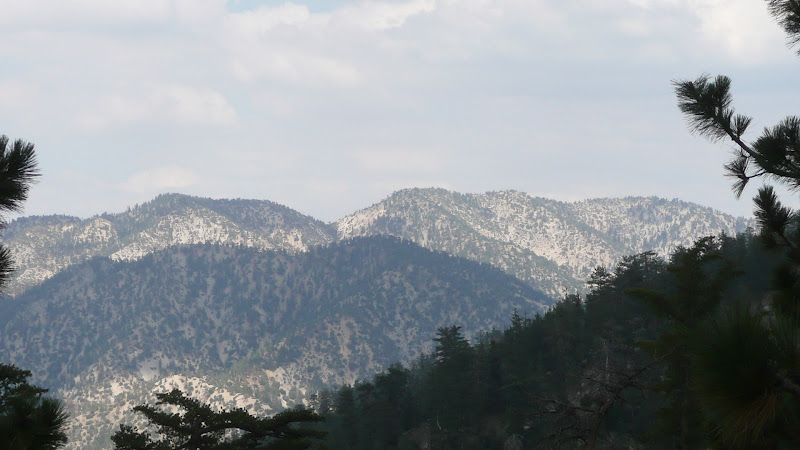
Which are peaks, and which are not? Hint: The three high points on the right horizon are, well, complicated.
HJ

Which are peaks, and which are not? Hint: The three high points on the right horizon are, well, complicated.
HJ
-
Elwood

- Posts: 623
- Joined: Fri Aug 15, 2008 5:23 pm
Think I'm looking at Pleasant View Ridge, Will Thrall Peak, Burkhart Saddle, Pallett Mountain (Continuation of Pleasant View Ridge), possibly Western ridge of Williamson, with Akawie in the midground.
-
Hikin_Jim
- Posts: 4688
- Joined: Thu Sep 27, 2007 9:04 pm
Very good; spoken by a man who knows. This is a bit of a tricky angle, so we're looking a bit more east here than might be readily apparent.Elwood wrote: Think I'm looking at Pleasant View Ridge, Will Thrall Peak, Burkhart Saddle, Pallett Mountain (Continuation of Pleasant View Ridge), possibly Western ridge of Williamson, with Akawie in the midground.
Here's a version of the photo with labels added: (click to enlarge)

The "complicated" I was referring to is with respect to the three high points on the horizon at the right of frame, which comprise Mt. Williamson. The USGS marks the high point (8214') on the right as the named summit. The HPS marks the summit as the middle high point (8244'). The highest point (8248'), the one on the left, is recognized by no one.
Pallet is out of frame in this photo. The high point to the left of Williamson has no name that I know of. The peak in the middle of frame is Goodykoontz, but the shoulder of a peak in the foreground is indeed Mt. Akawie which is marked on some maps (Tom Harrison) as "Buckhorn Peak."
The profiles of Pleasant View Ridge (HPS summit) and Thrall Peak do look much like that unnamed peak, don't they?
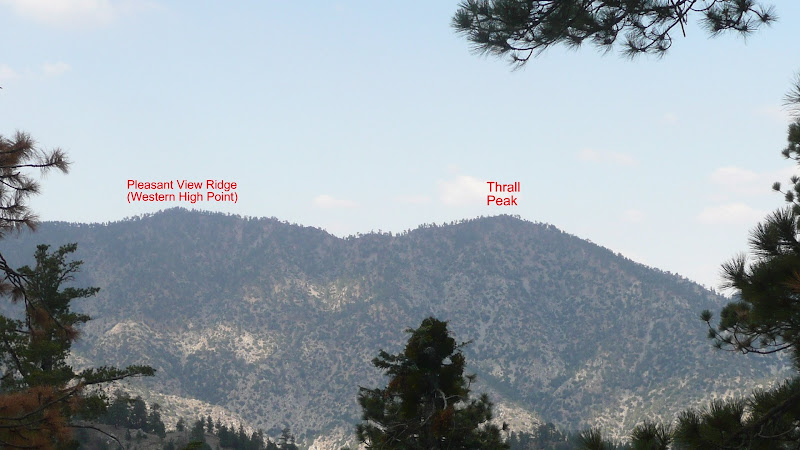
Which gives us another topographic oddity: Why is Thrall Peak the named summit when the higher summit just west has no official name and is simply known by the name of the ridge of which it is part?
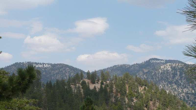
And then one last topograhic oddity from that vicinity: Why does flatish and indistinct Pallet Mountain have a name when it's higher more apical neighbor to the north has none?
HJ