
What kind of shape is the Rim trail in these days?cougarmagic wrote:This lovely specimen was seen today as I rode bikes with some friends from Mt Wilson, down the Rim Trail, and down to the West Fork. Lovely ride, by the way, I recommend it highly. Just watch where you step.
Rim Trail (Mt Wilson)
-
Hikin_Jim

- Posts: 4688
- Joined: Thu Sep 27, 2007 9:04 pm
-
cougarmagic

- Posts: 1411
- Joined: Wed May 07, 2008 5:21 pm
It was nice. Couple of small downed trees, a few places where you wouldn't want to stumble and fall a several hundred feet to certain death, but we made it just fine even carrying bikes around those spots. It's a beautiful trail - not many views, but nice and shady and forested. Toward the saddle, there is a lot of P.O. It was just starting to leaf out - I imagine when it's "full grown" it will reach across the trail, and anyone hiking will just have to bust through it.
-
Hikin_Jim
- Posts: 4688
- Joined: Thu Sep 27, 2007 9:04 pm
Not a lot of views? Interesting. It's been a long time since I've been on that trail -- that's the one from Newcomb Saddle to Mt. Wilson, yes? I was thinking there would be more views.
I definitely remember some serious drop offs!
I definitely remember some serious drop offs!
-
cougarmagic
- Posts: 1411
- Joined: Wed May 07, 2008 5:21 pm
Most of the trail is on the north side of the ridge, so I remember getting to the corners of switchbacks where there was some view, but most of it being pretty thick pine forest. Once we got to Newcomb saddle, and went past that - then we got some spectacular views. Really nice stuff too, with no roads, power lines, etc, so it felt very wilderness-y. It may be that I was more focused on not falling than the scenery though! 
-
Hikin_Jim
- Posts: 4688
- Joined: Thu Sep 27, 2007 9:04 pm
Anyone know what kind of shape the Rim Trail (from Newcomb Saddle to Mt. Wilson) is in?
One option for this Saturday is a Mt. Wilson - Sturtevant Trl - Sturtevant Camp - Newcomb Sdl - Rim Trl - Mt. Wilson loop, but I'm concerned that the Rim Trail might be in too bad of shape to do it. Anyone been on the trail lately?
HJ
One option for this Saturday is a Mt. Wilson - Sturtevant Trl - Sturtevant Camp - Newcomb Sdl - Rim Trl - Mt. Wilson loop, but I'm concerned that the Rim Trail might be in too bad of shape to do it. Anyone been on the trail lately?
HJ
-
AlanK

- Posts: 1069
- Joined: Thu Sep 27, 2007 9:28 pm
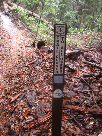
The last time I was in that area, the trail from Sturtevant Camp to Newcomb Saddle and over to Mt. Wilson was still marked "closed."
-
Hikin_Jim
- Posts: 4688
- Joined: Thu Sep 27, 2007 9:04 pm
Hi, Alan,AlanK wrote: The last time I was in that area, the trail from Sturtevant Camp to Newcomb Saddle and over to Mt. Wilson was still marked "closed."
At what location did you see that sign? I was at Sturtevant Camp a couple of weeks ago and saw no signs re the trail to Newcomb saddle.
HJ
-
HikeUp

- Posts: 4070
- Joined: Thu Sep 27, 2007 9:21 pm
I think those trails are outside of the closure area, but not sure what condition they are in. I was on the Rim trail last in 2007...several washouts. I'm wondering if the fire crews made things better when they were establishing lines up in that area. They might have even made a direct route down that ridge from Wilson to Newcomb Saddle. IIRC Elwood and maybe lik2hik have been in that area since the fire. Search the TR's.
-
blueshammer
- Posts: 105
- Joined: Wed Nov 25, 2009 1:03 pm
I vaguely remembering seeing signs over a year ago somewhere indicating that the Rim Trail is closed. Sorry, can't say for certain.
-
Hikin_Jim
- Posts: 4688
- Joined: Thu Sep 27, 2007 9:04 pm
OK. Maybe not this weekend, but I definitely want to check that area out.blueshammer wrote: I vaguely remembering seeing signs over a year ago somewhere indicating that the Rim Trail is closed. Sorry, can't say for certain.
Is Angeles Forest Highway open from lower Big T junction to Clear Creek?
HJ
-
cougarmagic
- Posts: 1411
- Joined: Wed May 07, 2008 5:21 pm
-
AlanK
- Posts: 1069
- Joined: Thu Sep 27, 2007 9:28 pm
The sign was at the start (Sturtevant Camp) of the trail heading up to Newcomb Pass. It was there as late as October 29. I may be by there tomorrow and will check it out. I last did the Newcomb Pass-Rim Trail in May of 2008 and would like to get back up there.Hikin_Jim wrote:Hi, Alan,AlanK wrote: The last time I was in that area, the trail from Sturtevant Camp to Newcomb Saddle and over to Mt. Wilson was still marked "closed."
At what location did you see that sign? I was at Sturtevant Camp a couple of weeks ago and saw no signs re the trail to Newcomb saddle.
-
Ze Hiker

- Posts: 1432
- Joined: Mon Jul 28, 2008 7:14 pm
saw that sign in late December. Avoided the urge to hike illegally. Must have been FO's voice in my head...
-
Hikin_Jim
- Posts: 4688
- Joined: Thu Sep 27, 2007 9:04 pm
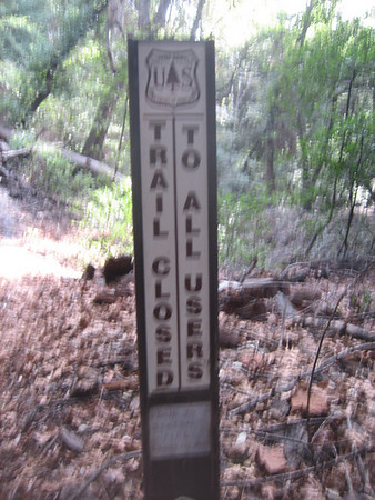
You mean here?AlanK wrote:The sign was at the start (Sturtevant Camp) of the trail heading up to Newcomb Pass. It was there as late as October 29. I may be by there tomorrow and will check it out. I last did the Newcomb Pass-Rim Trail in May of 2008 and would like to get back up there.Hikin_Jim wrote:Hi, Alan,AlanK wrote: The last time I was in that area, the trail from Sturtevant Camp to Newcomb Saddle and over to Mt. Wilson was still marked "closed."
At what location did you see that sign? I was at Sturtevant Camp a couple of weeks ago and saw no signs re the trail to Newcomb saddle.
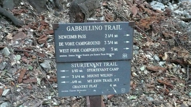
Was it affixed to the trail sign in the photo? Or was in close by? Just up the trail?
I went on the Zion Loop 1/22/2011 and didn't head up to Newcomb Saddle. If the sign was further up the trail, I wouldn't have seen it, but there was nothing in the immediate vicinity of the trail sign that I saw. Maybe I'm blind.
HJ
-
AlanK
- Posts: 1069
- Joined: Thu Sep 27, 2007 9:28 pm
That's the right spot. It was a couple of yards up the trail from the intersection.Hikin_Jim wrote: You mean here?
Was it affixed to the trail sign in the photo? Or was in close by? Just up the trail?
I went on the Zion Loop 1/22/2011 and didn't head up to Newcomb Saddle. If the sign was further up the trail, I wouldn't have seen it, but there was nothing in the immediate vicinity of the trail sign that I saw. Maybe I'm blind.
-
Hikin_Jim
- Posts: 4688
- Joined: Thu Sep 27, 2007 9:04 pm
OK, maybe I missed it. Someone said that it was just some whiteout used to scrawl something on one of those brown fiberglass trail markers that the USFS uses. Of course, they have opened up some new areas recently, and who knows if they've updated the signs.
HJ
HJ
-
PackerGreg

- Posts: 623
- Joined: Sat Sep 12, 2009 9:31 pm
The Rim Trail is probably still officially closed, but during the Station Fire various CalFire crews made a fuel break/emergency egress of it. That's not to say that the tread has been worked, but it shouldn't be a bushwhack.
-
HikeUp
- Posts: 4070
- Joined: Thu Sep 27, 2007 9:21 pm
Here's the sign Alan refers to...or at least a similar one...this is from Dec. 2009...

-
AlanK
- Posts: 1069
- Joined: Thu Sep 27, 2007 9:28 pm
That's the sign. 
I finally found my picture of it.
I finally found my picture of it.
-
lik2hik
- Posts: 82
- Joined: Sun Sep 30, 2007 8:46 am
Norma and I hiked thru there on 11 of 09 before the "trail closed" sign was posted. In fact, some weeks later, I was going by Sturtevant camp when they were installing the sign.
pictures -
pictures -
-
AlanK
- Posts: 1069
- Joined: Thu Sep 27, 2007 9:28 pm
Only because we beat this topic to de3ath -- pix from today.
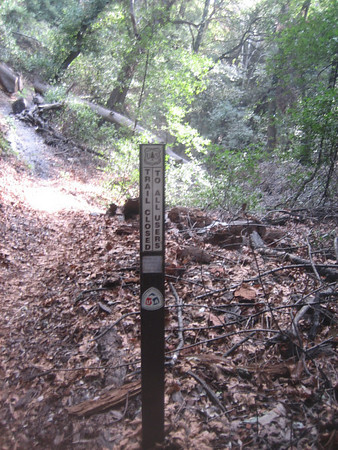
Damn! I miss that trail.
Damn! I miss that trail.
-
Hikin_Jim
- Posts: 4688
- Joined: Thu Sep 27, 2007 9:04 pm
So, how securely buried do you suppose that sign is? 

HJ
HJ
-
Illusive

- Posts: 115
- Joined: Fri Jan 28, 2011 2:19 pm
The Hundred mile run/event last year in August 2010 from wrightwood to pasadena took the trail from newcomb pass down into chantry flats.
Prior to that run the trail from chantry up to newcomb was in bad shape. Some volunteers must of gone and cleaned it up for the runners before the race because it was in much better shape after the race.
The trail from newcomb pass to wilson at the pass looks to be in decent shape but I haven't hiked up it or gone up the trail more than you can see from newcomb.
-
Mike P

- Posts: 1005
- Joined: Tue Oct 02, 2007 10:48 pm
On the day of the AC 100 last year, we cleaned out the upper section of the trail. There were two or three downed trees that blocked the trail with subsequent erosion. (We run the Newcomb's Saddle Aid Station every year.)Illusive wrote: The Hundred mile run/event last year in August 2010 from wrightwood to pasadena took the trail from newcomb pass down into chantry flats.
Prior to that run the trail from chantry up to newcomb was in bad shape. Some volunteers must of gone and cleaned it up for the runners before the race because it was in much better shape after the race.
The trail from newcomb pass to wilson at the pass looks to be in decent shape but I haven't hiked up it or gone up the trail more than you can see from newcomb.
-
norma r

- Posts: 707
- Joined: Thu Nov 06, 2008 4:22 pm
i was up on the Rim Trail via Newcomb Pass on Nov 1, 2009. at that time the trail was still open. we didn't encounter any trail closure signs. two guys we met at the Pass said the Rim Trail was pretty sketchy and warned us to be careful. we didn't find it any worse for wear than narrow parts of the DBB trail. we wanted to see how the Station Fire left the area and that we did witness.  my pix are over a year old, but here's a link: https://picasaweb.google.com/ryan.norma ... ountWilson#
-
MattCav

- Posts: 356
- Joined: Thu Sep 23, 2010 4:13 am
Wow... Ironically I left Chantry to go to Newcomb Pass yesterday. Unfortunately the Gabrileno trail from Sturtevant Camp is definitely still closed. One of my friends recently ran into a ranger who actually let them travel that trail to Devore. They said its pretty sketch in parts right now.
-
Illusive
- Posts: 115
- Joined: Fri Jan 28, 2011 2:19 pm
That explains that then. Thanks for cleaning up the trailMike P wrote:On the day of the AC 100 last year, we cleaned out the upper section of the trail. There were two or three downed trees that blocked the trail with subsequent erosion. (We run the Newcomb's Saddle Aid Station every year.)Illusive wrote: The Hundred mile run/event last year in August 2010 from wrightwood to pasadena took the trail from newcomb pass down into chantry flats.
Prior to that run the trail from chantry up to newcomb was in bad shape. Some volunteers must of gone and cleaned it up for the runners before the race because it was in much better shape after the race.
The trail from newcomb pass to wilson at the pass looks to be in decent shape but I haven't hiked up it or gone up the trail more than you can see from newcomb.