
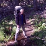
We hiked up the San Bernadino Peak Trail from Angeles Oaks. Camped one night in Columbine Camp (tons of water in the stream running through camp). Camped the next night at Limber Pine Bench, where there were gusty winds all night, but seriously excellent views all around. Limber Pine Spring was running nicely right next to the trail just up the hill from camp. Day-Hiked that afternoon up to both San Bernardino and East San Bernardino Peaks, and found one lingering patch of snow along the ridge between them. Got up at midnight to check out the beautiful lights of the city below us. Nice! Woke up super-early to view the dawn, then broke camp and hiked all the way out. We reached the trailhead by eleven, and got home to San Diego before rush hour.
Special thanks to Simonov for the tip on camping at Limber Pine Bench, which he says is one of his favorite campsites. And I can see why. Its only bad point is when it's windy, but that's often the trade-off for a great view.
This was our first time on the western end of the nine peaks. The trail itself was really nice, well graded, with only a couple of spots in the chaparral section that could use some pruning back, and not very many downed trees. What I need to do now is hike the middle section of the SG Wilderness. I'll have to get my son to join me for a long weekend and do the entire nine peak traverse. Sounds like a plan.
Trip Report with lots of Pictures
San Gorgonio Wilderness, San Bernardino Peak Trail - July 16
-
jfr
- Posts: 154
- Joined: Sat Dec 12, 2009 3:01 pm
-
rokclimbr

- Posts: 124
- Joined: Mon Jan 03, 2011 5:32 pm
I love it up there! The views are spectacular. I went camping at Limber Pine Bench when I was a kid, I do remember it being windy too  Love the photos!!
-
jfr
- Posts: 154
- Joined: Sat Dec 12, 2009 3:01 pm
Oh, I forgot to mention this in my original post: On our way out, on Monday July 18, we met some folks hiking up the trail who had a weimaraner as their "leader". A bit later, we found a camera in the middle of the trail. I probably should have left it there, but I didn't. And I probably should have left a note at the trailhead sign, but I also didn't (I'm too high-tech to have old-school things like pens and paper - perhaps this is a case of the old ways being the best ways - lesson learned). So here's a picture of the camera owner's "owner"

Please send me a PM if you know the dog in question. On the drive home I was thinking that it might have been Tracie B's dog, so I sent her a PM that very day, but it turned out she posted a message on the board at about the time we were hiking, so no go. I hope this works, as I don't need another camera. I take too many pictures as it is.
Please send me a PM if you know the dog in question. On the drive home I was thinking that it might have been Tracie B's dog, so I sent her a PM that very day, but it turned out she posted a message on the board at about the time we were hiking, so no go. I hope this works, as I don't need another camera. I take too many pictures as it is.
My hiking trip reports: https://hikingtales.com/
-
lilbitmo

- Posts: 1092
- Joined: Tue Mar 04, 2008 9:44 pm
Great Trip Report and Pictures JFR
You might want to log into or become a member of the board for the San Gorgonio Wilderness Association http://www.sgwa.org/ and post a message on that board to help find the owner of the camera.
Under the title "The Wilderness" down near the bottom it says "Backcountry BB (for bulletin board)" go in there and register, then post the message.
Not all the folks monitor our board and vise versa. Good luck.
-
Hikin_Jim

- Posts: 4688
- Joined: Thu Sep 27, 2007 9:04 pm
Wow. Nice stuff.
And lotsa water at Columbine which has the reputation for usually being dry. Maybe I'll have to check it out some time. How were the mosquitoes there?
Looks like a nice hike overall. Thanks for the HIGHLY motivating photos.
HJ
P.S. Now if you want to do the remaining seven (of the nine peaks), here's my idea of a good backpacking route for it.
I'd start at South Fork (A), head on up to the fork for Dry and Dollar Lake (E), then head up to Dry Lake (F) and camp for an easy first day at Lodgepole (G) where there is water available. You could even pack your water the short distance to Fish Creek Saddle (H) and sleep there if you wanted a bit more out of your first day.
The second day, you'd head over to Mine Shaft Saddle (I) and start up the Sky High Trail. When the Sky High Trail tops out and crosses the great SE ridge of San Gorgonio (J), just walk up the darned ridge to the summit (M). High altitude and not as easy as a trail, but just class 1 (walking) and easy navigation. Saves a lot of distance. Then head west to Jepson (P), Little Charlton (S), and Charlton (U). Last time through, I dropped my pack at the saddle between the Charltons, (T), did Charlton, came back to my pack, and re-joined the trail at "V". I spent my second night at High Meadow Springs which I ran out of letters to designate but is between "W" and "X."
The third day, I went and did Alto Diablo which is right off the trail and is silly that it's called a peak. I then went past Shields, dropped my pack in the saddle to the west of Shields, and then did the summit of Shields. I then went west to Anderson, did Anderson and then dropped down the Forsee Creek Trail. From the trailhead at Forsee Creek, I had arranged for a car shuttle. You could walk back to South Fork, but that makes for a long last day. That last day is long enough as it is.
Just some thoughts. It's all good.
HJ
-
jfr
- Posts: 154
- Joined: Sat Dec 12, 2009 3:01 pm
Thanks, Jim! Nice to see you back in the saddle, posting away once again.
As for your question, no there weren't too many mosquitoes at Columbine. Of course, we also went to bed before sunset, so they may have come out for an evening snack. The gnats are also mostly gone.
I like your route for the nine peaks. Is there a use trail (or better yet, a sign pointing the way) down to High Meadow Springs? I don't even see an official campsite on the acme topo.
As for doing all nine, I'm not likely to get a shuttle or a second car up there, as I'd be coming from San Diego. I was thinking about stashing a bike in the woods at the terminus, but if I did it this way I'd want the bike to be at the uphill end of route 38 for a relatively easy coast to the car. That would change the timing/direction of the whole thing. Could you whip up an Acme Map of all nine from the other direction, with two nights near water? Minimal biking would be nice, so PLEASE don't end it at the Fish Creek trailhead!
My hiking trip reports: https://hikingtales.com/
-
Hikin_Jim
- Posts: 4688
- Joined: Thu Sep 27, 2007 9:04 pm
It's nice to be on even if I'm not getting out and hiking much any more. Bed bugs have been SUCH a huge disruption. Argh.
So, there is a loop to do the nine peaks. It can be done either way. You need a 2.7 mile (per Google Maps) bike shuttle to join the ends of loop. Your shuttle never touches Hwy 38 and stays in the Barton Flats area. I'd probably do the loop in a clockwise direction so that I came out at Forsee Creek and could ride my bike downhill on the dirt road until I got to Jenks Lake Road. Jenks Lake Road is relatively flat (and paved). It should be a snap to get back to your car at the S. Fork trailhead from the Forsee Creek Trailhead. Besides, it makes more sense from a driving standpoint to go to Forsee Creek first, stash a bike, and then drive to South Fork which is further in.
So, the loop for all nine starts just as I described it before at the S Fork Trailhead (but drop a bike at the Forsee Creek TH first). Head up the S Fork Trail to S Fork Meadows (E) where the trail forks. Take the fork to the east to Dry Lake (F) and then go to Lodgepole Springs (G), 7.3 miles from the trailhead. There is good water at Lodgepole. This year, there may be water running even further up the drainage than Lodgepole. I don't know; I haven't been for a while.
Now, there are a couple of choices here. You could camp at Lodgepole which gives you a convenient source of water but gives you more climbing and more miles for day two OR you could continue on the unmaintained but still followable trail another mile to Fish Creek Saddle, porting all your water with you. There will be no easily available water until the following evening. For me, FCS makes sense, but which ever.
From Fish Creek Saddle or Lodgepole Spring, proceed to Lodgepole Saddle which is marked as point "Z" on this second map. If you didn't stay at Fish Creek Saddle, you can take an old, barely followable mining trail from the Lodgepole Springs area straight to Lodgepole Saddle.
From "Z," basically you're following the points in reverse alphabetical order until you get to the Forsee Creek trailhead "A". Note that you can only drive up the road as far as "A" even though the map shows it going farther.
The trip goes much like as outlined previously BUT instead of staying at High Meadow Springs (P), stay at Trail Fork Springs which I didn't mark but is just north of Anderson Peak (L). The exact location of the camp is pretty well marked by the base of the blue letter "T" in "Trail Fork Springs."
Day one is just your hike in to your first night's camp, 8.3 miles if you go to Fish Creek Saddle.
Day two bags Gorgonio (W), Jepson (V), Little Charlton (T), Charlton (S), Alto Diablo (N), and Shields (M) and ends at Trail Fork Springs, 10.4 miles not counting side trips to peaks.
Day three bags Anderson (L) by heading almost due South from the trail junction by Trail Fork Springs and then hitting E SB Peak (K) and SB Peak (J) then dropping down to the Manzanita Springs Junction (H) and taking the trail to Johns Meadow Camp (C). Note that the trail isn't maintained any more and is not shown on the topo but that it is there. From Johns Meadow Camp, take the easy, relatively flat trail to your stashed bike at the Forsee Creek TH and then ride 2.7 pretty easy miles to the South Fork TH to your car.
HJ