
No pictures yet since my camera took on too much water.
The end selection for this particluar trip was an ambitious one that fell well short. After being left go at a some day use area legally, and perhaps there was a mirage of just how appopraite this route was(hmppf) I was off. The Big Tujunga is back with some flower displays and I was really annoyed that the area was still closed.
This particular creek was flowing very strong over solid rock , and was free of major debris and vegetation. I had thought it was to end in an optional 50ft rappel of a waterfall, but before that was a downclimb made interesting by the amount of water flowing. The 50fter was extremely strong, almost a waterslide...which was bypassed canyon left.
It was some time before getting to the BigT river...but it was so peaceful out...a perfect spring day. The BigT river had a lot of sediment in this first part, eliminating previous swim portions....quickly enough, the narrows were approached. The water here was certainly flowing fast towards the extreme range, with minor whitewater. The first obstacle was bypassed on an sketchy canyon right complex route/downclimb.
I hadnt yet been to the next obstacle, a supposed optional rappel(and that people prefer a handline) or a 60ft jump...or so thats what I remebered. What I met was an impassable waterfall, but a possible downclimb to avoid it. Next to the 60ft downclimb, a hardware rope was hanging showing the sheer determiantion to make use of this narrow place by the crowd that inhabits this place....that opened my eyes wide.
The downclimb ends about 8ft short of the river, so I went to lower my pack to below....but it it went awry and I lost another pack to the fast moving water. Implusively I went after my backpack and ran down the slightly curving slope of the wall and then crashing into the water below.
But next, I now noticed that I was in a delicate position since the next part of the watercourse was a swiftwater swim with minor rapids.
Feet first...kind of fun and exciting down about 3 pools to a nifty whirlpool. It wasnt over yet. All kind of crazy water here, but nothing overwhelming just like before.
After that was a neat walk along the canyon bottom. 2 big waterfalls right off the canyon wall touching down next to the river...nice stuff. Now Im getting long-winded here, so just to say it was as best as this place gets....sandy beaches, clean rock, warm temps....with some animal tracks.
Finally I had reached the end of the river with no sign of my backpack and about 1.5 hours of daylight left. At first I was deliberating what my options were...possibly hike out from here and walk through the night or still search for my backpack(since all I was wearing was my canyoneering shirt and some pants)....or just settle down at this locale. I decided for the last option.
My first problem was my clothes were still wet, but that wasnt going to change in 1.5 hours. Taking a wild guess, I collected some vegetation from nearby and dug a hole in the sand. I was looking good...until lower temps with a cold wind really set in. The vegetation turned cold to the touch and my partially wet pants were really cold. My shirt was still wet but keeping me in good spirits.Eventually my feet went numb, which made for a strange experience when my feet shook up to regenerate my lower body.
Temps rose and I woke up to everything in color and in excellent condition. Hiking out, I would see that the dam was not releasing water, and now it was backed up past Fox Creek(Fox Creek was backed up as well). Theres an island about 120 ft high near White Oak canyon and it had about 30ft of height left!. The waterfall along Joesphine Creek was looking the best Ive ever seen. The landing area of the strong waterfall was wide open and clear of trees.
As far as the hike out along this canyoneering trail, there were a couple of landslides on the lower portion. The upper landslide renedered this one sketchy(6 out of 10 on the sketchiness scale)..so no more casual hikers or dogs.
Getting a ride back..."Where is your backpack?"...eek.
Survey of the BigT 4/14-4/15
-
HikeUp

- Posts: 4070
- Joined: Thu Sep 27, 2007 9:21 pm
Just another day (or 2) in a canyon for you, eh? Epic stuff.
-
cougarmagic

- Posts: 1411
- Joined: Wed May 07, 2008 5:21 pm
Very cool. Glad you got to see all that. The reservoir backed up to GFF - now that's something!
I have to think all this runoff is due to the lack of vegetation to suck it all up. We did get a lot of rain, but not that much rain....
It's very interesting which parts get scoured, and which get filled in. If I were a scientist, I'd have to figure that out.
I have to think all this runoff is due to the lack of vegetation to suck it all up. We did get a lot of rain, but not that much rain....
It's very interesting which parts get scoured, and which get filled in. If I were a scientist, I'd have to figure that out.
-
AW~

- Posts: 2109
- Joined: Mon Oct 01, 2007 12:00 pm
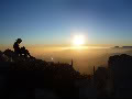
pictures....
early on

looking back at a downclimb

about 7ft wide slow stemming

waterfall

monkey canyon / jackazz area

obstacle#1

last photo

early on
looking back at a downclimb
about 7ft wide slow stemming
waterfall
monkey canyon / jackazz area
obstacle#1
last photo
-
AW~
- Posts: 2109
- Joined: Mon Oct 01, 2007 12:00 pm
The Big Tujunga is now the Crystal Lake of the forest service.cougarmagic wrote: Very cool. Glad you got to see all that. The reservoir backed up to GFF - now that's something!
I have to think all this runoff is due to the lack of vegetation to suck it all up. We did get a lot of rain, but not that much rain....
It's very interesting which parts get scoured, and which get filled in. If I were a scientist, I'd have to figure that out.
The reservoir being backed up... I got a river rat intertube hehehe. Who knew the topo map would be mostly correct some day?
-
Taco

- Snownado survivor
- Posts: 6192
- Joined: Thu Sep 27, 2007 4:35 pm
Looks like it's time to go on a multiday canyoneering adventure out there. 
-
AW~
- Posts: 2109
- Joined: Mon Oct 01, 2007 12:00 pm
Funny and Not So Funny Happenings in Big T
http://www.angelesrising.org/index.php/ ... -in-big-t/
"This afternoon I took a drive up the road to check out the dam. As you might expect, the canyon had lots of cyclists, motorized and not, plus other visitors pulled off the the side of the road, parking and picnicking as though they never saw the “Forest Closed” signs.
The dam, as it happens, is full, and not with water.This picture shows pretty clearly that the dam is completely filled with sediment. I have no idea what plans exist for excavating all that sand, silt, rock and debris, but I find it almost impossible to believe that the job could be done before next winter’s storms. And until the dam is dug out, all the water coming down the canyon is going to flow right over the spillway...."

^Hmm...that exact picture a few days ago had water over all that sediment...wild.
http://www.angelesrising.org/index.php/ ... -in-big-t/
"This afternoon I took a drive up the road to check out the dam. As you might expect, the canyon had lots of cyclists, motorized and not, plus other visitors pulled off the the side of the road, parking and picnicking as though they never saw the “Forest Closed” signs.
The dam, as it happens, is full, and not with water.This picture shows pretty clearly that the dam is completely filled with sediment. I have no idea what plans exist for excavating all that sand, silt, rock and debris, but I find it almost impossible to believe that the job could be done before next winter’s storms. And until the dam is dug out, all the water coming down the canyon is going to flow right over the spillway...."
^Hmm...that exact picture a few days ago had water over all that sediment...wild.
-
Hikin_Jim

- Posts: 4688
- Joined: Thu Sep 27, 2007 9:04 pm
Wow. That is a lot of sediment. When/if they remove the sediment, I wonder what kind of stress that old concrete arch dam will be subjected to?
HJ
HJ
-
Taco
- Snownado survivor
- Posts: 6192
- Joined: Thu Sep 27, 2007 4:35 pm
Blow it up. That would be awesome.