Lake Piru, Agua Blanca Creek, and Devil's Gateway 03/13/11

Archived TRs for the Los Padres National Forest.
Post Reply
User avatar
cougarmagic
Posts: 1409
Joined: Wed May 07, 2008 5:21 pm

Post by cougarmagic »

This one has been on the list for a while. The weather was perfect, so Matt, Bernd and I decided to make this the day to explore the Los Padres.

See bsmith's TR, with better information than I'm about to give: (mileages and such).

All photos: http://s484.photobucket.com/albums/rr20 ... u%20Creek/

We coughed up $12 to drive into the boat launch area, saving a few miles of road biking. The morning was cool and lovely (and a bit overexposed).

Image

Riding on the paved road, without worrying about cars was a nice treat. The hills are steep enough for a workout, but never too bad.

Looking back at the top of Lake Piru:

Image

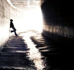
We came to the first crossing of Piru Creek, and were unsure if we should try crossing it with the bikes. The current was deep, and we knew there would be one or two more crossings up the road. We decided to go for it, since we were more interested in this trail than the Agua Blanca trail. The water was up about mid-thigh, and cold, and it's always tough to cross a stream when you can't see the bowling ball boulders you're about to stub your toes on. Nevertheless, our intrepid band soldiered on without much more than wet feet.

The trail was a bit hard to find at first (because we decided ahead of time that it would be, and didn't bother to look for or notice the cairns and flagging tape pointing the way to a pretty nicely maintained trail)

Image

The trail climbs about 100' above the stream a few times, giving nice views up and down the canyon.

Image

Sometimes it's just easier to wander in the streambed:

Image

This lovely thing is probably 300' high. If I were the kind of person who liked to climb things, I would definitely want to climb that.

Image

Sandcastles:

Image

As we neared the Devil's Gateway, the kitty prints appeared. From here on out, I mostly have close up pictures of dirt! :lol:

Image

Big impressive gateway, blah blah blah:

Image

Tiny bobcat:

Image

Big cousin cougar:

Image

Big Ursine beastie:

Image

Gosh, this sure would be a great place for someone to put a trail camera - if some person wasn't too damn lazy to carry one along today. :roll:

Utz - official Party Mix of Agua Blanca Creek:

Image

Hiking back:

Image

The hike back to the bikes took very little time and was quite easy and nice. The bike ride back for some reason was several miles longer, and much steeper, than it was when we rode in. I'm not sure how this happens - it seems to be a common feature of bike rides.

This was a great hike, and a beautiful place. We didn't see any condors, but there were many hawks, some herons, lizards, snakes, and of course plenty of tracks of all local species. Seems to be a great haven for the critters.
User avatar
davantalus
Posts: 203
Joined: Mon Jun 08, 2009 9:09 am

Post by davantalus »

Niiiice! I gotta see that gateway for myself.
User avatar
norma r
Posts: 707
Joined: Thu Nov 06, 2008 4:22 pm

Post by norma r »

Great report CM! Loved the Gateway and especially like that the LPNF is teeming with critters. :D
User avatar
Taco
Snownado survivor
Posts: 6010
Joined: Thu Sep 27, 2007 4:35 pm

Post by Taco »

Very cool wall there.
User avatar
Elwood
Posts: 612
Joined: Fri Aug 15, 2008 5:23 pm

Post by Elwood »

Nice concolor tracks. I can just imagine those kitties walking around Los Padres NF, er Angeles N.F..
User avatar
TracieB
Posts: 216
Joined: Mon Feb 22, 2010 8:57 am

Post by TracieB »

Nice! Love the creek/cyn shots!
User avatar
Hikin_Jim
Posts: 4686
Joined: Thu Sep 27, 2007 9:04 pm

Post by Hikin_Jim »

Nice!!

HJ
User avatar
HikeUp
Posts: 3853
Joined: Thu Sep 27, 2007 9:21 pm

Post by HikeUp »

Set up a cam and trap a Condor! Yeah...that's it.
User avatar
He219
Posts: 386
Joined: Thu Sep 27, 2007 11:18 pm

Post by He219 »

Very cool, CM!
:D
User avatar
James
Posts: 79
Joined: Thu Feb 04, 2010 3:28 pm

Post by James »

Great TR and photos. Is that Piru Gorge? The creek runs through the canyons and comes out at Frenchmans Flats below Lake Pyramid?
User avatar
cougarmagic
Posts: 1409
Joined: Wed May 07, 2008 5:21 pm

Post by cougarmagic »

James wrote: Is that Piru Gorge? The creek runs through the canyons and comes out at Frenchmans Flats below Lake Pyramid?
Close - Agua Blanca creek feeds into Piru Gorge just above the lake. If I have time later today, I'll post an ACME map. I would also like to hike from Frenchman's Flat down to the lake someday.

And condors are on the list HU - I was thinking Tar Creek would be a good place.
User avatar
Hikin_Jim
Posts: 4686
Joined: Thu Sep 27, 2007 9:04 pm

Post by Hikin_Jim »

Acme? Yes please. :)

HJ
User avatar
cougarmagic
Posts: 1409
Joined: Wed May 07, 2008 5:21 pm

Post by cougarmagic »

OK here goes:

http://mapper.acme.com/?ll=34.52296,-11 ... 0Piru%20CA

All markers are approximate...

"B" is where the bike ride on pavement starts
"D" the road becomes dirt
"C" is the junction of Piru Creek and Agua Blanca Creek. We went West (ish). If you wanted to go to Frenchman's Flat, you would go North on Piru Creek. This is also where we locked up the bikes, and continued on foot.
"A" is the Devil's Gateway
User avatar
James
Posts: 79
Joined: Thu Feb 04, 2010 3:28 pm

Post by James »

Thanks for the map. The hike from Lake Piru to Frenchmans Flat is fun (never went Flats to lake, only lake to flats). It can get very hot in that gorge but there is plenty of water to cool off in. I haven't hiked it in a very long time but there was lots of camping on sandbars and good trout fishing in both the pools and the running stream. There was also lots of poison oak from what I remember. Sometimes the trail would vanish and we just walked up the stream until we got to a bend and found the trail again.
User avatar
AW~
Posts: 2040
Joined: Mon Oct 01, 2007 12:00 pm

Post by AW~ »

good stuff.....there was a tr for the big narrows as well...
http://vccanyoneering.blogspot.com/2010 ... lanca.html
"The walls squeezed to about ten to twenty feet wide, and rose 500 to 600 feet high"

youtube:

500 to 700? Hmm....seems suspect....but high none the less.
User avatar
bsmith
Posts: 119
Joined: Wed Oct 28, 2009 7:36 pm

Post by bsmith »

cougarmagic wrote: All markers are approximate...

"B" is where the bike ride on pavement starts
"D" the road becomes dirt
"C" is the junction of Piru Creek and Agua Blanca Creek. We went West (ish). If you wanted to go to Frenchman's Flat, you would go North on Piru Creek. This is also where we locked up the bikes, and continued on foot.
"A" is the Devil's Gateway
i'm glad you had a great trip out there - it doesn't receive a lot of visitors and consequently more critters abound.

please forgive me, but i'd like to offer two minor corrections to the acme map markers in the hopes that future followers won't be surprised:

"A" is the gate / start of the bike ride; and
"B" is close to devil's gateway - but actually actually shy of there by about 1/3. it is located at 34.549.16, -118.80272.

now is the time to go - before it gets too hot - but be mindful of any storms and subsequent runoffs. they rescued over 30 people out of the ojai ranger district alone this past weekend. twenty boy scouts were rescued from the santa barbara district. all were due to hypothermia, wet, and being effectively cut off by rising creek waters from the previously advertised storm.
Post Reply