Page 1 of 1
22-mile Loop in Los Padres Nat'l Forest 2.9.11
Posted: Sat Feb 12, 2011 12:00 pm
by norma r
Did a crazy-a$$ hike in the LPNF with Ventura County friends Camille, Robert and Ron on Wednesday. We started at 7:30 am at Santa Paula Canyon Trail behind Thomas Aquinas College which i thought was in Ojai but is technically Santa Paula. We traveled up the creek bed and then headed north toward Jackson Falls and eventually finding the old Last Chance Trail which can be GPS'd but is rarely traveled and becomes undiscernable for stretches. We followed the GPS coordinates over ridges and up drainages and eventually through heavy throny brush that became a bushwack nightmare. The Day Fire of 2005 cleared some areas of brush and prompted thick overgrowth of others. What fun!

Just before sunset we reached with great relief our high point the Red Reef Trail and I was never so happy to see a fire road. Small remnants of snow remained on the north slope of Topatopa Bluff and at 6,100 feet it was quite chilly out. We gobbled the remaining food and candy we had left took a few sunset photos and moved like lightning by headlamp for the last 9 miles and reached a car we had parked at the Sisar Cyn TH just after 8 pm.
Total Stats: 22 miles, 7502 elevation gain, 12.5 hrs and 8 tired feet
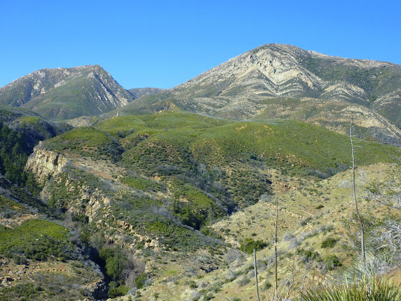
1:40 pm Cream Puff (unofficial name) and Hines Peak. We are aiming for the low point between and behind the two peaks.
all of my pix are here:
https://picasaweb.google.com/ryan.norma ... ToSisarCyn#
Re: 22-mile Loop in Los Padres Nat'l Forest 2.9.11
Posted: Sat Feb 12, 2011 4:22 pm
by Hikin_Jim
norma r wrote: Did a crazy-a$$ hike in the LPNF with Ventura County friends Camille, Robert and Ron on Wednesday. We started at 7:30 am at Santa Paula Canyon Trail behind Thomas Aquinas College which i thought was in Ojai but is technically Santa Paula. We traveled up the creek bed and then headed north toward Jackson Falls and eventually finding the old Last Chance Trail which can be GPS'd but is rarely traveled and becomes undiscernable for stretches. We followed the GPS coordinates over ridges and up drainages and eventually through heavy throny brush that became a bushwack nightmare. The Day Fire of 2005 cleared some areas of brush and prompted thick overgrowth of others. What fun!
Just before sunset we reached with great relief our high point the Red Reef Trail and I was never so happy to see a fire road. Small remnants of snow remained on the north slope of Topatopa Bluff and at 6,100 feet it was quite chilly out. We gobbled the remaining food and candy we had left took a few sunset photos and moved like lightning by headlamp for the last 9 miles and reached a car we had parked at the Sisar Cyn TH just after 8 pm.
Total Stats: 22 miles, 7502 elevation gain, 12.5 hrs and 8 tired feet
1:40 pm Cream Puff (unofficial name) and Hines Peak. We are aiming for the low point between and behind the two peaks.
all of my pix are here:
https://picasaweb.google.com/ryan.norma ... ToSisarCyn#
Norma,
What's it like going up Santa Paula Canyon these days? I know they've had a series of bad storm damage incidents over the last several years.
I don't suppose you have a plot on a topo map (hint, hint:
Acme Mapper)

of your route do you?
HJ
Re: 22-mile Loop in Los Padres Nat'l Forest 2.9.11
Posted: Sat Feb 12, 2011 4:56 pm
by cougarmagic

"the last nine miles" is not a phrase you hear tossed around much! (at least not by me...) A great accomplishment, and an interesting trip! I loved your photos, as always.
Not sure about the tracks - except they are much to big to be bobcat, and they're not bear. Likely cougar, possible big 'yote is my vote.
Re: 22-mile Loop in Los Padres Nat'l Forest 2.9.11
Posted: Sat Feb 12, 2011 6:01 pm
by lilbitmo
Norma,
Nice TR and great pictures as always - you sure you didn't used to do commercials - you know the ones with that silly rabbit banging on a drum, cause you always keep going, and going and going

one of these days I'm going to get you to take me up there and show me your other backyard
Re: 22-mile Loop in Los Padres Nat'l Forest 2.9.11
Posted: Sat Feb 12, 2011 6:04 pm
by Taco
Hey abNormaL, is there an easy way to the bottom of the Topa Topa Bluffs, fer climbing/scouting?
Re: 22-mile Loop in Los Padres Nat'l Forest 2.9.11
Posted: Sat Feb 12, 2011 7:12 pm
by Uncle Rico
Beast hike norma r.
Re: 22-mile Loop in Los Padres Nat'l Forest 2.9.11
Posted: Sat Feb 12, 2011 10:26 pm
by MattCav
sick. absolutely sick.
Re: 22-mile Loop in Los Padres Nat'l Forest 2.9.11
Posted: Mon Feb 14, 2011 8:06 am
by Illusive
Nice photos. Bushwhacking is one of my least favorite things to encounter hiking. Small patches are okay but anything over a few minutes and it gets old really quick.
Those are some epic stats for a dayhike.
Re: 22-mile Loop in Los Padres Nat'l Forest 2.9.11
Posted: Mon Feb 14, 2011 12:11 pm
by He219
Very cool TR and photos, Norma!
Well done.
Re: 22-mile Loop in Los Padres Nat'l Forest 2.9.11
Posted: Mon Feb 14, 2011 9:48 pm
by norma r
sorry for the late response. gone for a few days. Tina & Zach dragged my arse up Rabbitt/Villager yesterday. epic week for my poor feet!
HJ, Robert said he was making a GPS track so i will look into it for you. Santa Paula Canyon is fine. good orienteering or lots of patience makes for a fun rumble and stumble through the creek bed. i just realized i never posted my pix on Picasa when we did a full day scramble all the way up (and down canyon) to the saddle below SP Peak last year. we didn't summit the peak since we had just done it a few weeks prior the normal way.

up a trail. i will have to look through my memory cards and find them, post them and will send you a link. it was a blast, though my glutes were not so happy 2 days later. i have to credit the success of that trip and this loop to the amazing orientation skills of Ron Hudson. he is The Master. lucky for me he lives in Ventura County.
Taco, i'm told you can obtain a permit and take the fire road from Lion Canyon up to nearly the base of Topatopa Bluff. but you need 4WD. little Japanese coupe's won't get you there.

i'll look into beta on that for you. oh btw, Ron said the road to Tar Creek wasn't a seasonal closure, i think it was something about damage. my currently fried brain can't remember exactly what the story is, so i will check on that too.
thanks for the funny posts all. it makes up for all the whining i did that day.

Re: 22-mile Loop in Los Padres Nat'l Forest 2.9.11
Posted: Tue Feb 15, 2011 10:23 am
by Taco
Thanks Norma! You can be my porter for that trip, how's that sound?
Re: 22-mile Loop in Los Padres Nat'l Forest 2.9.11
Posted: Tue Feb 15, 2011 12:22 pm
by Hikin_Jim
norma r wrote: sorry for the late response. gone for a few days. Tina & Zach dragged my arse up Rabbitt/Villager yesterday. epic week for my poor feet!
I do hope your arse has recovered by now.
norma r wrote: HJ, Robert said he was making a GPS track so i will look into it for you.
If he can plot that on a topo, that would be very cool.
norma r wrote: Santa Paula Canyon is fine. good orienteering or lots of patience makes for a fun rumble and stumble through the creek bed. i just realized i never posted my pix on Picasa when we did a full day scramble all the way up (and down canyon) to the saddle below SP Peak last year. we didn't summit the peak since we had just done it a few weeks prior the normal way.
up a trail. i will have to look through my memory cards and find them, post them and will send you a link. it was a blast, though my glutes were not so happy 2 days later. i have to credit the success of that trip and this loop to the amazing orientation skills of Ron Hudson. he is The Master. lucky for me he lives in Ventura County.
SP canyon sounds fun. Haven't been up that way for a while. I'll have to check it out.
Thanks,
HJ
Re: 22-mile Loop in Los Padres Nat'l Forest 2.9.11
Posted: Wed Feb 16, 2011 12:08 pm
by Sam Page
Wow, stiff outing. I'd never even heard of that area.