San Gorgonio Sunrise

Archived TRs for ranges in California.
Post Reply
User avatar
hvydrt
Posts: 494
Joined: Thu Sep 27, 2007 8:18 pm

Post by hvydrt »

I did a backpacking trip in the San Gorgonio wilderness this weekend. We made a nice camp around 9300' after a fairly leisurely hike in on Saturday.

Image

While eating dinner we talked about climbing up to the peak for sunrise Sunday morning....several hours later, after attempting to sleep, and after failing at waking John, Jeremy and I set off for the peak around 4:15AM Jeremy was feeling some altitude sickness and decided to head back to camp so I continued onto the northwest ridge. Once I got out of the trees and onto the actual ridge, the winds were very strong, some gusts enough to knock me around. The top of the ridge and near the summit was probably the worst wind/ spindrift I have ever been in. Of course I didn't bring my balaclava or goggles so I made do with sunglasses (in the dark for the first hour or so) and the hood of my shell. After reaching the top of the ridge I dropped down a hundred feet or so to avoid the worst of the wind and flying debris and headed east toward the summit.

video of spindrift near the summit:


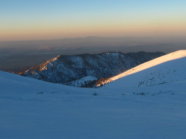
I found a spot to hide from the wind in one of the rock shelters on the east end of the summit just in time for the sunrise.

video of view from rock shelter:


Image

It was too cold to stand still for very long, so I headed back for the ridge. To get back on the ridge, I had to walk head on into the spindrift coming up over the crest. This was pain full! I kept my head down as much as possible, but my face was pelted with blowing snow until I was able to get a few hundred feet down the ridge. Part way down, John had woken from his slumber and was headed for the peak. Luckily he was prepared for the wind with goggles and a face mask and summited about an hour later After getting down near the trees I could finally relax and rest for a few minutes, from there is was an easy walk back to camp.

The South Fork Trail was spotty to Poopout Hill, then mostly hard packed snow and ice to South Fork Meadows. Past the meadow, we left the pack down path and snowshoes were needed. Switched to crampons at about 10,500 were there was harder snow and some ice. There are large drifts and cornices in lots of places between Jepson and San Gorgonio. In addition to the route we went, we saw a few others on Saturday going up the ridge that ends near bump 11490. It seems like there is a lot of snow above 10,000', more than I have seen in the past few years, but below that it seems to be less than years past.

more Pictures and Videos are here

.
User avatar
lilbitmo
Posts: 1092
Joined: Tue Mar 04, 2008 9:44 pm

Post by lilbitmo »

Great pictures and TR Hvydrt - for this outing we may need to change that to Hvysnw or Hvywnd :shock: :D

Glad to see that there's still some snow to be played in up there. How was traffic coming back on the 38? And did anyone capture any pictures of the north side of Galena and the little San Bernardino's?
User avatar
harryquach
Posts: 4
Joined: Thu Oct 21, 2010 10:23 pm

Post by harryquach »

Great pics, had a good time
User avatar
Ze Hiker
Posts: 1430
Joined: Mon Jul 28, 2008 7:14 pm

Post by Ze Hiker »

pics made the summit trek worth it I bet...well at least for us! :)
User avatar
hvydrt
Posts: 494
Joined: Thu Sep 27, 2007 8:18 pm

Post by hvydrt »

lilbitmo, no pictures of the little san bernardino mountains, but you can see Galena in picture 22, at least I think that's Galena, might be little San gorgonio????
User avatar
He219
Posts: 386
Joined: Thu Sep 27, 2007 11:18 pm

Post by He219 »

Looks like a great trip, Mark!
Well done.

i really like this pic:
Image
:D
User avatar
Johnny Bronson
Posts: 179
Joined: Mon May 31, 2010 2:04 pm

Post by Johnny Bronson »

Beautiful!
User avatar
norma r
Posts: 707
Joined: Thu Nov 06, 2008 4:22 pm

Post by norma r »

Thanks for posting Hvydrt. :D Beautiful sunrise photos! It must have been cold at that hour and with that wind, but what a sight to behold! Nice to see that San G is holding onto its snow.
User avatar
Burchey
Posts: 304
Joined: Tue Dec 28, 2010 11:28 am

Post by Burchey »

Nicely done! If I'd known you were out there heading to the top, I would have raced you from the other side. My partner in crime wasn't feeling up to the summit either, so we skipped it. Brutal wind during the night (10,300 feet).
User avatar
hvydrt
Posts: 494
Joined: Thu Sep 27, 2007 8:18 pm

Post by hvydrt »

lilbitmo wrote: traffic coming back on the 38? And did anyone capture any pictures of the north side of Galena........
missed your question about the 38. It wasn't bad at all, coming or going. Lots of cars, but moving at the speed limit.

I found a better shot of Galena in my pictures:

Image
User avatar
Dave G
Posts: 321
Joined: Sun Jun 22, 2008 9:51 am

Post by Dave G »

Nice TR & Pics, Mark. I was wondering how you guys did up there.
It sure can get windy in the SGW. One time it was so bad that I somehow misplaced my partner on Jepson and had to hunker down in the rocks for awhile. When we finally reconnected on San G a couple of hours later, the first thing out of our mouths was "I figured you were dead!". :o
Good times!
User avatar
Burchey
Posts: 304
Joined: Tue Dec 28, 2010 11:28 am

Post by Burchey »

Dave G wrote: When we finally reconnected on San G a couple of hours later, the first thing out of our mouths was "I figured you were dead!". :o
Good times!
I like your style, Dave
Post Reply