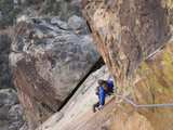
Mill Creek Jumpoff to Vivian Creek Trail, 11-Jun-2010
-
Tim

- Posts: 560
- Joined: Tue Apr 08, 2008 8:55 pm
Remember a couple of years ago this hiker went missing on San Gorgonio? After a couple of days, they found her in Raywood Flats, which is way south of San G. I've always wondered how she got there from the Vivian Creek Trail, so I checked out to see if the MCJO could be linked up to the top of ridge above High Camp.

-
Taco

- Snownado survivor
- Posts: 6230
- Joined: Thu Sep 27, 2007 4:35 pm
Very nice movie, Tim! What camera did you use?
-
Dave G

- Posts: 321
- Joined: Sun Jun 22, 2008 9:51 am
Nice! Are you holding the camera in your hand? I'm thinking you must have long arms or some sort of extension mast thingie? 
-
cougarmagic

- Posts: 1414
- Joined: Wed May 07, 2008 5:21 pm
Very interesting trip, and the video is great! That slope gave me vertigo!
-
lilbitmo

- Posts: 1092
- Joined: Tue Mar 04, 2008 9:44 pm
Indiana"Tim"Jones 
Tim, where exactly is Raywood Flats?
Tim, where exactly is Raywood Flats?
-
hvydrt
- Posts: 494
- Joined: Thu Sep 27, 2007 8:18 pm
Awesome Tim. I was up Galena a few weeks ago and looking at possible routes. I want to try that route next winter or spring.
-
Tim
- Posts: 560
- Joined: Tue Apr 08, 2008 8:55 pm
Thanks all!
HU: Roger that!
TDR: Camera is just a small Canon SD880IS. The video mode is actually kinda crappy but it has a nice wide lens. Need to upgrade to HD for my next production!
DG: Haha, my arms are not very long. In some shots I rigged the camera to my trekking pole and in others I just held it while it was on a mini tripod. I also used the trekking pole as a crude Steadicam by holding it in a certain way to balance it.
CM: Yeah, I saw so many interesting things on this trip. Those snow bridges holding up thousands of pounds of rocks was crazy!
LB: Here's RF: http://mapper.acme.com/?ll=34.04601,-11 ... ntain%20CA
HD: I was thinking about the same thing regarding winter routes. So many possibilities!
It's so cool that we can have real, genuine adventures out here just like Indy and most of the population doesn't even know about it!
-
RyanB
- Posts: 17
- Joined: Sun Feb 22, 2009 10:43 am
That map shows a trail to San G summit via East Fork Cabin/Middle Fork Jumpoff. Its not on my Tom Harrison map from 2000. Does that trail still exist?Tim wrote:LB: Here's RF: http://mapper.acme.com/?ll=34.04601,-11 ... ntain%20CA
-
Taco
- Snownado survivor
- Posts: 6230
- Joined: Thu Sep 27, 2007 4:35 pm
That's amazing quality for a "crappy" camera! If you don't mind me asking, what do you plan on upgrading to?

-
EManBevHills

- Posts: 387
- Joined: Fri Sep 28, 2007 12:40 am
That was a pleasure to watch. Nice job, Tim!
-
lilbitmo
- Posts: 1092
- Joined: Tue Mar 04, 2008 9:44 pm
Tim,
If that hiker actauly went from Vivian Creek Trail all the way to "Raywood Flats" before she was picked up that's way out of the way, that must have been a crazy ordeal?
If that hiker actauly went from Vivian Creek Trail all the way to "Raywood Flats" before she was picked up that's way out of the way, that must have been a crazy ordeal?
-
Ze Hiker

- Posts: 1432
- Joined: Mon Jul 28, 2008 7:14 pm
awesome Tim! so that gully looked like it had brush, but how bad was it? did you go all the way up to intersect the VC trail?
as for that lost girl, i remember her claiming she felt like "she was on a trail, then it got steeper and steeper on some dirt ground." very descriptive!
as for that lost girl, i remember her claiming she felt like "she was on a trail, then it got steeper and steeper on some dirt ground." very descriptive!
-
Tim
- Posts: 560
- Joined: Tue Apr 08, 2008 8:55 pm
Ryan: Not sure about that trail. Hardly anyone ever goes back there and it's pretty brushy so I assume everything is overgrown now. In John Robinson's book, Hike #61 does describe a trail from Millard Canyon Rd to Raywood Flat and then on to Silverwood Falls, but even he admits it's overgrown.
TDR: The crappy part is when the camera sees anything white or really bright (like snow), the sensor gets overloaded or something and it gets these annoying pink vertical streaks. Not sure yet on which camera. The new Canon SD4000 is pretty good, but expensive. They're all kinda meh.
HE/EBH: Thanks again!
LB: She was out there for a couple of nights and even weathered a thunderstorm. At one point she said she saw a monkey. Ironically Moe the chimp had escaped from a compound a few days before (but that was way west of her location so it seems unlikely it was Moe). I can see how she ended up in RF, because there is a small creek on the other side of the MCJO and she said she kept following a stream. I contacted her on Facebook but she didn't seem to remember much or want to talk about it. Probably everything looked all the same to her anyway.
Ze: The gully starts to get brushy about halfway up, then it just gets more and more dense. The best path was to exit the gully and start headed up either side of the gully. At first I went towards the east flank because it's really rocky over there with some pretty fun looking Class 3, but getting to the rocks through the brush proved difficult, so I went back and headed up the west flank, which was a safer bet. From there, it was pretty easy to weave through the manzanita and gain the ridge to the VC trail.
-
Taco
- Snownado survivor
- Posts: 6230
- Joined: Thu Sep 27, 2007 4:35 pm
Same thing happens with several digicams I've used.