White cliffs of Middle Fork Lytle Creek: 03-13-2010

TRs for the San Gabriel Mountains.
Post Reply
User avatar
HikeUp
Posts: 3861
Joined: Thu Sep 27, 2007 9:21 pm

Post by HikeUp »

Hiked up into an unnamed (as far as I know) side canyon off of Middle Fork Lytle Creek. The Middle Fork Trail crosses the mouth of this side canyon about 1 mile from the trail head. The canyon is dry at this point but after climbing up canyon a short ways there is a nice flow. Hard to get lost in this canyon at this time - just follow the water until you reach the waterfalls (a series of at least 3 falls - lowest one is about 20' maybe?).

I actually didn't know about the falls, I just suspected they were there. If they didn't materialize I was going to head further up the canyon in hopes of gaining the ridge that leads to high point 7465 (and eventually Telegraph Peak if you're ambitious). Turns out that the hanging valley above the falls went unexplored by me today. It may be possible for good rock climbers to get up and around the falls, but that doesn't include me.

Map. Head up side canyon at point "A", waterfalls at "C", hanging valley at "D", high point 7465 at "F", Telegraph's north ridge at "G".

Pics & vids.

White cliffs and waterfalls...
Image
User avatar
Taco
Snownado survivor
Posts: 6010
Joined: Thu Sep 27, 2007 4:35 pm

Post by Taco »

Too awesome. So what was the rock like? Chalky (since it's the Chalk Peak area)? Anything out of the ordinary? I have to go there asap!
User avatar
HikeUp
Posts: 3861
Joined: Thu Sep 27, 2007 9:21 pm

Post by HikeUp »

TacoDelRio wrote:So what was the rock like? Chalky (since it's the Chalk Peak area)? Anything out of the ordinary?
White and chalky :wink: . Not as crumbly as a lot of the crap in the San Gabs, but not solid either.

I might be going back up there soon...this peaklet looked like it would be fun...
Image
Image
User avatar
Taco
Snownado survivor
Posts: 6010
Joined: Thu Sep 27, 2007 4:35 pm

Post by Taco »

By any chance did you see the east or northeast or whatever the big face of that peak near Chalk Peak?
User avatar
GigaMike
Posts: 164
Joined: Sun Feb 24, 2008 4:37 pm

Post by GigaMike »

I need to check out that area sometime before summer arrives. Great pics!
User avatar
HikeUp
Posts: 3861
Joined: Thu Sep 27, 2007 9:21 pm

Post by HikeUp »

Thanks Mike. This is only the second time I've been in the Lytle Creek area and I'm really impressed. The rough road to the trail head is both a blessing and a curse. Keeps the crowds down but takes a while to cover the distance.

Taco - I think you're referring to the north face of point 7465. I didn't see it, but it's one of the reasons I want to get up there. The waterfalls kept me from getting up this time, but I have a plan B which I want to explore soon.
User avatar
Taco
Snownado survivor
Posts: 6010
Joined: Thu Sep 27, 2007 4:35 pm

Post by Taco »

HikeUp wrote:Thanks Mike. This is only the second time I've been in the Lytle Creek area and I'm really impressed. The rough road to the trail head is both a blessing and a curse. Keeps the crowds down but takes a while to cover the distance.

Taco - I think you're referring to the north face of point 7465. I didn't see it, but it's one of the reasons I want to get up there. The waterfalls kept me from getting up this time, but I have a plan B which I want to explore soon.
I wish to go with!
User avatar
AW~
Posts: 2043
Joined: Mon Oct 01, 2007 12:00 pm

Post by AW~ »

Nice explore! unique looking area. Due to other stuff, cant get out for awhile on the weekends, but look forward to seeing this one explored further!
User avatar
HikeUp
Posts: 3861
Joined: Thu Sep 27, 2007 9:21 pm

Post by HikeUp »

TacoDelRio wrote:I wish to go with!
You betcha. Right now I'm thinking this weekend - dunno which day though. PM to work the details out. Can't convince you to play hooky AW?
User avatar
He219
Posts: 386
Joined: Thu Sep 27, 2007 11:18 pm

Post by He219 »

Nice pix, HikeUp!
Beautiful terrain.
User avatar
Taco
Snownado survivor
Posts: 6010
Joined: Thu Sep 27, 2007 4:35 pm

Post by Taco »

HikeUp wrote:
TacoDelRio wrote:I wish to go with!
You betcha. Right now I'm thinking this weekend - dunno which day though. PM to work the details out. Can't convince you to play hooky AW?
I'm free on Sunday. I shouldn't have said I want to go just yet, as I don't think I can make it.
User avatar
HikeUp
Posts: 3861
Joined: Thu Sep 27, 2007 9:21 pm

Post by HikeUp »

No worries...if it happens it happens. Besides, don't you have some ice to climb somewhere? :)
User avatar
HikeUp
Posts: 3861
Joined: Thu Sep 27, 2007 9:21 pm

Post by HikeUp »

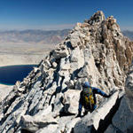
Finally got around to trying plan B. It failed (as I figured it would). So I settled for a hike up to High Point 5610 which offered some very nice views of the area. It was quite a scramble up some very loose slopes to get to the ridge that leads up to the high point. The ridge itself was a basic class 2 scramble over some rocky outcrops and around brush, but it was fun although short.

Anyway, here are some pics.

Middle Fork Lytle Creek...
Image

The white cliffs with the series of waterfalls in the middle...
Image
User avatar
Taco
Snownado survivor
Posts: 6010
Joined: Thu Sep 27, 2007 4:35 pm

Post by Taco »

Sweet. 8)
User avatar
AW~
Posts: 2043
Joined: Mon Oct 01, 2007 12:00 pm

Post by AW~ »

Eeks..thats that then.
User avatar
HikeUp
Posts: 3861
Joined: Thu Sep 27, 2007 9:21 pm

Post by HikeUp »

AW wrote:Eeks..thats that then.
There's a plan C but frankly I'm tired of the drive. Plan C has a high probability of failure too.
Post Reply