Baden-Powell to Shoemaker Road: Epic Fail

TRs for the San Gabriel Mountains.
User avatar
Zach
Posts: 522
Joined: Sun Jan 04, 2009 4:25 pm

Post by Zach »

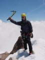
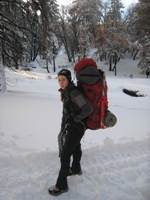
My original plan was to head out on saturday for a 2 day backpacking trip of the entire Sheep Mtn Wilderness aka the Death March. Upon checking the weather reports I decided against the trip since it would entail some cold weather/snow gear that i had not brought with me to O.C.. Instead I piggy-backed on Lilbitmo's trip to Mt. Baden-Powell. I was to hike with them to the summit and then through-hike the ridge, summiting a few peaks before dropping down to Rattlesnake Peak and then back to Shoemaker Rd, where my bro was waiting with a car ride back home.
The next day Patrick and I summited Baden-Powell around 10am, "complication" aside ;) 
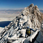
and we parted ways. Elwood, it was nice to meet you! I continued on to Mt. Burnham, then Throop (by 11am) and then hit Mt. Hawkins, Middle Hawkins, and South Hawkins (by 1245). Here I took a 15 minute lunch and started the cross-country section of my hike. On the ridge between S. Hawkins and Rattlesnake the weather took a turn for the worse, clouds and fog rolled in and I lost my visual reference of Rattlesnake Peak. I consulted my map and saw that by staying on the eastern-most side of the ridge it would take me to my next destination. I followed the ridge for quite some time and when i arrived at what I thought was Rattlesnake's summit I found no registry and no familiar land-marks. Another look at the map revealed I had, in fact, taken a different ridge... my original assumption about staying on the east-most ridge turned out to be a mistake! Ouch! I looked back up from where I came and realized the weather and altitude gain would be too much for me at that point. I decided to descend further, into Devil's Gulch which would eventually empty into the East Fork on the San Gabriel River (territory I am very familiar with). I scrambled down the ridge and started making my way through the dense foliage and creek bed towards the San Gabriel River. The going was extremely slow. Everything was overgrown, dead trees and giant boulder cascades made for a wet and rather painful descent. By nightfall I still had not reached the end. I refilled my water supply and pressed on. By 7pm I was puzzled to find the water was flowing TOWARDS me not with me. I made a wrong turn somewhere. Tired, hungry, and a little nervous I decided it was time to hunker down for the night. Daylight would reveal the terrain and sort things out. The weather report called for rain so I found a spot on the shoulder of the gulch and checked to make sure none of San Gabriel's famously loose rock was above me. I found a dense bush and crawled inside. My shoes were soaked from the creek so I took them off and rung out my socks. I wrapped my feet with my extra jacket and slid my feet into my backpack and zipped them in. I donned my down jacket and weatherproof shell and thus began a miserable night. It was cold, flurries of snow would fall mixed with cold rain. I struggled to keep my feet warm. On top of that I was having muscle spasms every time I would straighten my legs. I slept a bit but was awake most of the night. When dawn arrived I packed up my belongings and headed out (630ish). I backtracked a couple hundred yards to the main gulch and resumed my descent. A few hours later the San Gabriel River came into view and I got excited. Low and behold, not a quarter of a mile away from the end the gulch cliffed out in a 40-50 foot drop. The walls were smooth granite and it was obvious I wasn't going to be able to pass. I back tracked and found a rock wall that looked semi-climbable and decided it was my best bet. A few minutes later I had gained the ridge and was confronted with almost a thousand feet of dense manzanita mingled with buckthorn (that stuff was nasty!). I pressed on, fighting the brush and feeling more and more tired. Halfway up the ridge I heard a faint sound... it got louder and louder until the whooping of helicopter blades revealed an L.A. County Sherrif's Helo searching the East Fork canyon... and Iron Mountain?! My first thought was, "oh shit." My parents must have freaked out. I tried to signal them with my light, then my white map but to no avail. They were searching the gullies on Iron for some reason. They zoomed by several more times throughout the day but each time there was no response. I gained the top of the ridge and realized I was just west of the bridge to nowhere. I descended the other side of the ridge to Rattlesnake Canyon. It was worst than before, the path was littered with dead and down trees and patches of densely overgrown thorn-bushes. I crawled and clawed my way down the canyon, slipping multiple times on slippery tree trunks (landed on my head once :) until I emerged to find myself right by the San Gabriel River. I hauled ass on the bridge trail until i came to Heaton Flats parking lot. From across the way I saw a Sheriff... then a group of people milling about, and then a shout as my Dad came running to greet me. The next few minutes were spent explaining the past 24 hours to the sheriff and then a quick checkup by the medics on scene. It was embarrassing. Thanks to all the people involved in my non-rescue.

Looking back I think there were several things I should have done differently.
Parents: Maybe I shouldn't tell them the next time i go hiking :wink:. I had told my parents on multiple occasions to always wait at least 24hours before getting worried. They jumped the gun a little but I can't blame them as this is the first time I've missed my pickup time. I think carrying one of those spot gps locators would have been great since I would have been able to send out an "ok" message the minute I was running late.
Routefinding: I'm still torn about the decision I made. I think with the condition of my body and the weather, I was spending the night out there either way. A GPS would have given me great accuracy and would have probably avoided the whole situation, a map and compass was useless with the weather being what it was. No way to orient myself. So up/down either way I think it turned into an overnighter when I read my map wrong. I'm curious to hear what you guys think/would have done.
Flamethrower: to clear a path so there's no need to bush-whack


Pics: http://s300.photobucket.com/albums/nn30 ... er%20Road/
User avatar
cougarmagic
Posts: 1409
Joined: Wed May 07, 2008 5:21 pm

Post by cougarmagic »

12/06/2009 09:14 ANF-4851 Overdue/Missing Hiker Search & Rescue Mt Baden Powell to Heaton Flat
I saw this on WILDCAD (http://www.wildcad.net/WCANF.htm) and though...hmmm...BP to Heaton Flat? that's ambitious - Wonder if it's a forum person!?

Very glad you made it out OK and sounds like you took good care of yourself finding shelter.

I have a SPOT messenger, and though I haven't had to use it to that degree, it definitely comes in handy for letting people know you're going to be late, but are OK. I bet your folks will get you one for Christmas!

Again, glad you are OK and good job making it out of there.
User avatar
simonov
Posts: 1087
Joined: Tue Nov 27, 2007 5:44 pm
Location: Reno, NV
Contact:

Post by simonov »

Whoa, high adventure!

A compass certainly would have been useful. You would have been able to use it to orient your map correctly, even if distant landmarks weren't visible.

Edit: your photo album requires a Photobucket login.
Nunc est bibendum
User avatar
Rick Kent
Posts: 150
Joined: Tue Oct 02, 2007 11:21 am

Post by Rick Kent »

Wow! Apparently I wasn't the only one to get mixed up by those damn clouds.

Great report! Upon reading your initial route selection I had a good idea how it turned out. Glad your alive. I had a taste of this route once before (along the ridge) but descending down to the East Fork from the ridge is surely a far more formidable challenge. Given the limited visibility with the low clouds I'd say your chances of successfully finding your way from South Hawkins to Rattlesnake was low even with honed route-finding skills. I think it was a bit of a gamble to head down to the East Fork but fortunately you worked it out. SAR was probably premature but given the pending storm I'm sure they were highly motivated to locate you quickly. Sometimes things don't work out as planned. This was one of those times. Nothing more. Thankfully you didn't pay the ultimate price and you had quite the adventure in the process.
User avatar
HikeUp
Posts: 3861
Joined: Thu Sep 27, 2007 9:21 pm

Post by HikeUp »

Looks like you descended Devil Gulch. I know AW would be very interested in hearing about this!

High adventure indeed. Glad you made it out...call this an epic win!

That ridge between South Hawkins and Rattlesnake looks pretty indistinct around the 6000' level. Perhaps this is where your plan to stay on the east side of the ridge went awry? A constant use of your compass and taking a bearing on visible objects every minute or so might have been able to keep you on the ridge, depending on visibility, or lack of, in whiteout or heavy brush conditions. Dunno, obviously.
User avatar
lilbitmo
Posts: 1092
Joined: Tue Mar 04, 2008 9:44 pm

Post by lilbitmo »

Zach wrote:The next day Patrick and I summited Baden-Powell around 10am, "complication" aside :wink:
If you are referring to the "Newbie" that I brought up Baden-Powell (as the "Complication aside", he was slow as hell as it was his first summit ever, and he'd had back surgery a year or so ago) it's ok to pick on him, he doesn't have access to this blog site :wink:

I was never truly worried about you or your ability to get out - we've done enough trails, bowls, snow and such to know you would make the right choice when it was time - you did :D
Simonov wrote:A compass certainly would have been useful. You would have been able to use it to orient your map correctly, even if distant landmarks weren't visible.
That assumes that you are on a trail or in an area that allows you to move about freely and that a ridge (the one you are on) is the correct one - once you get into the thick brush (that completely dominates the saddle between S. Hawkins and Rattlesnake) it's almost impossible to know without some visual cues where you are in white out conditions. Telling the difference between one ridgeline or the next is useless unless you've been there before and you still have the chance of choosing the wrong one. Once he committed to going down the one he chose it was going to be "nearly super human to regain" the ridge and find the correct one, if the "White Out conditions persisted" (only he knows). Bush whacking downhill is one thing, doing it for hours on end uphill is another - it's thick out there, we did Rattlesnake in the winter last year going through both tunnels and taking the faint use trail that leads up the far north ridgeline directly to the summit and that was thick as well, I cannot imagine the amount of crap he fought his way through two ridgelines over from this. A GPS may have helped or trying to stay on the upper ridge as "Hikeup" suggested, going as far south on that ridge as possible, using the compass to stay out of the brush as long as possible but eventually you have to work your way through it - some of that stuff is as tall as you. :twisted:
cougarmagic wrote:SPOT messenger - I bet your folks will get you one for Christmas!
And they will get you that "Flamethrower" you are requesting - the rest of us will get you a "cheap" pair of "loppers" :roll: :shock:

I sure would like to see a bunch of us "Cut a Trail" between Rattlesnake and S. Hawkins. Once the Crystal Lake area opens I'm all for doing a little trail making :D

I'm absolutely glad that you made it out without any serious injuries, you did a great job of staying calm and making decision that were "success based (as we talked last night) and not "fear bases" which usually leads to more problems - nice work Zach. :D
User avatar
Ze Hiker
Posts: 1430
Joined: Mon Jul 28, 2008 7:14 pm

Post by Ze Hiker »

wow! nice job hunkering down and eventually getting out of that.

so, did you end up on this ridge?
User avatar
Sam Page
Posts: 267
Joined: Fri Sep 04, 2009 10:59 am

Post by Sam Page »

"Tired, hungry, and a little nervous I decided it was time to hunker down for the night. Daylight would reveal the terrain and sort things out."

Sounds like a very wise decision. Glad you got out ok.
User avatar
EnFuego
Posts: 677
Joined: Mon Dec 15, 2008 11:14 am

Post by EnFuego »

How come I'm not reading this on Hiker Hell????

All kidding aside, glad you're OK. And really glad to hear you took your parka with you. Sounds like quite the trip.

Wow! I can't even imagine what you felt like once you decided to hunker down for the night. Knowing you were missing you're pick-up from your bro, I bet you were worried as hell for his sake, not so much you're sake.

This is a good way however to get that SPOT beacon or a GPS for Christmas. Not sure you needed to go through so much trouble for it. Maybe just asking you're parents or friends to chip infor one would have worked. :lol:

Nice TR.

So is the Death march doable in a day??? :shock:
User avatar
EManBevHills
Posts: 387
Joined: Fri Sep 28, 2007 12:40 am

Post by EManBevHills »

Nice to know your choices worked out!
I must admit, I was MOST concerned about your footware.

After being involved in a heli rescue on Baldy one winter -- when a woman training for Aconcagua (I believe) -- slipped and broke her heel, I always carry pons, just in case. And I put them on as soon as I think they might be needed. I also carry my trademark whippets, which saved my ass more than once, thank you....
User avatar
Zach
Posts: 522
Joined: Sun Jan 04, 2009 4:25 pm

Post by Zach »

HikeUp: Devil's Gulch is correct. Actually, I just looked at my map. Damn was I wrong about staying east. Right where the ridge forks for Rattlesnake and that unnamed ridge that forms Devil's Gulch my Tom Harrison map has the big "NATIONAL" forest label precisely where they diverge. No excuses though... dumb mistake. As far as compasses and orienting and that sort of thing, it was pretty damn limited. Once you see my pictures of all the soup rolling over the mountains you'll see what I mean. Visibility was maybe 100-200 feet when this all happened.

Simonov: Link should be working now... I hope.

Lilbitmo: Joking about the noob, he was cool... karma kicked me in the ass for that one.

Ze: That's the one

Enfuego: I did feel pretty guilty about standing him up... and sort of forcing him to be the barer of bad news. As far as the Death March goes... you'd have to have prime conditions... and there would have to be a trail cut between rattlesnake and S. Hawkins... and even then, it'd be a long, long 24hrs. Rick Kent could probably tell you better. I have yet to do the SA ridge, seeing as how both of those sections seem to be the toughest parts he'd probably know more... it sucks because any way you slice it, i think you'd be hitting one of the two "crux" sections in the dark.

EManBevHills: I had on some new balance trail running shoes... goretex which kept me warm and dry up until the canyoneering part of my adventure. After that, it just plain sucked. Also, what are pons and whippets?

My hands were cut up pretty good, both the top and palms got a good once over. My legs received the same treatment... all the way up to my thighs. And of course, it wouldn't be the SG's if I didnt have a huge patch of poison oak on my forearm and my cheek? (even through my beard??!) I went to the doc's to get some prophylactic antibiotics for the cuts plus the 3 liters of delicious unfiltered/treated SG stream water I drank. They dug around on one of my fingers for a splinter which they ended up not being able to fish out, and the damn poison oak shows up now, so another trip to the doc's will be in order since I'm HIGHLY sensitive to this sh!t.
User avatar
edenooch
Posts: 504
Joined: Fri Jul 03, 2009 7:42 pm

Post by edenooch »

are your hands like that cuase of the thorn bush?
User avatar
Zach
Posts: 522
Joined: Sun Jan 04, 2009 4:25 pm

Post by Zach »

no i went a little overboard with the pumice stone taking a shower this morning ;)

:lol:

Jokes aside, there must have been around 6 or 7 different types of plants out there ranging from large spikes (like yucca) to these nasty vines that would tangle around my legs with a million little stinging needles.
User avatar
Taco
Snownado survivor
Posts: 6010
Joined: Thu Sep 27, 2007 4:35 pm

Post by Taco »

SWEET!

Glad you're OK dude. Kinda sucks about the SAR thing. How did they interact with you when you made it back to HF?
User avatar
Zach
Posts: 522
Joined: Sun Jan 04, 2009 4:25 pm

Post by Zach »

They all cheered, then when i started apologizing for everything they said something like, "too bad you weren't out there an hour longer we would have gotten a free helicopter ride."
User avatar
Taco
Snownado survivor
Posts: 6010
Joined: Thu Sep 27, 2007 4:35 pm

Post by Taco »

Would they have charged you anything for a rescue?
User avatar
Zach
Posts: 522
Joined: Sun Jan 04, 2009 4:25 pm

Post by Zach »

No, one of the guys said they don't charge because people wouldn't call if they knew how much it would cost.
User avatar
EManBevHills
Posts: 387
Joined: Fri Sep 28, 2007 12:40 am

Post by EManBevHills »

For a reminder, here's what you were trying to navigate through:

http://picasaweb.google.com/EManBevHill ... 4492422658

:P
User avatar
GigaMike
Posts: 164
Joined: Sun Feb 24, 2008 4:37 pm

Post by GigaMike »

Thanks for the TR, Zach. I'm glad everything worked out ok.
User avatar
Tim
Posts: 560
Joined: Tue Apr 08, 2008 8:55 pm

Post by Tim »

Wow, what a story! Glad to hear you made it out under your own power. These epics are interesting. If you make it out okay, they're the most memorable things you ever do, but if it goes the other way you end up regretting a lot of stuff. I've come close a few times and at the time I'm usually pissed off at myself for making such stupid mistakes. But when I make it out, it feels pretty good. I guess we all walk a fine line.
Zach wrote:I'm curious to hear what you guys think/would have done.
It's really tough to go cross country without any visual reference. Even with a GPS, you still have to do local routefinding because the GPS only puts you at a location. You still have to get around rocks, brush, boulders, etc. by looking and seeing what's ahead. I was on Leatherneck Ridge a few weeks back and was still on route after dark and it was a little tricky at first to get back to Long Valley even with a GPS because there were huge boulders everywhere and I could only see 20-30 ft in front of me.

GPS is good insurance, though. I have mine loaded with 20ft topo data for all of California and I draw in my route before I head off. I also bring a paper map because it's easier to look at a bigger area on the paper map. Some GPS screens have failed in the cold so I bring a compass for backup and for direction finding when you're standing still. Some people poo-poo GPS since it takes the adventure out of getting lost, but I see no shame in using one.

Like you, I leave word with my family to not call the authorities until late in the second day (this gives me enough time to get out on my own if I have to bivy) but I can see why your parents called since you had a pickup time. I also started carrying a McMurdo PLB which helps reassure my family. I tell them that unless that PLB is going off, definitely do not call SAR before my overdue time.
User avatar
norma r
Posts: 707
Joined: Thu Nov 06, 2008 4:22 pm

Post by norma r »

Zach,

thanks for posting your TR. i'm really glad you made it out OK. after my bivy of '07, i always hike with an extra pair of socks in cold weather. would a signal mirror have helped when the heli's were above you?
User avatar
Zach
Posts: 522
Joined: Sun Jan 04, 2009 4:25 pm

Post by Zach »

Tim: thanks for your input, I'm definitely changing a few things about my cross-country hiking strategy

Norma: I doubt it... cloud cover had the sun hidden almost the entire time. I dunno, they were kind of far off and moving pretty quick... I wonder if there's some way to practice mirror signaling?
User avatar
bsmith
Posts: 119
Joined: Wed Oct 28, 2009 7:36 pm

Post by bsmith »

Zach wrote:I wonder if there's some way to practice mirror signaling?
near my work there's a tall building - four, maybe five stories. it's been some time, but i try to "paint" it when there's no one there. and at different times of the day - for the different altitudes of the sun.
i've read that sar pilots can / will see the flash from 10 - 50 miles away. overcast days, even with a bright moon - i think that may be a stretch, but i'd try it if the situation arose. you just need to keep flashing it ("painting") in their direction. the eye will pick it up.

oh, and by the way, great job!
User avatar
Taco
Snownado survivor
Posts: 6010
Joined: Thu Sep 27, 2007 4:35 pm

Post by Taco »

What he said.
User avatar
whatmeworry
Posts: 57
Joined: Tue Mar 03, 2009 1:28 pm

Post by whatmeworry »

TacoDelRio wrote:Would they have charged you anything for a rescue?
As was stated in at least one other post, there is not a policy or practice to charge for SAR operations in the majority of the nation. There are a few exceptions, but it is important for people to know that these are very significant exceptions.

No one should hesitate to call for help if your or your family feels it is needed. SAR will respond when we are called. How much urgency and/or additional resources are requested will depend on a number of factors. We'd rather respond and not be needed than respond when it is too late.

A mirror was mentioned as a piece of gear worth carrying. It is true that a flash from a mirror can be seen from a LONG way away. It is very difficult to spot someone from a moving helicopter. A mirror is a great tool and will work in surprisingly overcast conditions (try it out). Strobe lights are also functional in the day. Headlamps can be used to create a light source that can be bounced from a mirror (although the "range" will be pretty limited). Don't limit mirror flashing to aircraft. You can flash searchers on a cross canyon ridge or along a distant trail. A lightweight whistle is valuable as well since the sound will carry much further and more clearly than your voice.

Interested in SAR - Sierra Madre is recruiting now (http://smsr.org/content/view/14/45/). Contact your local sheriff for more teams in the local area. San Dimas Mountain Rescue (http://sdmrt.com/) was the lead team on this search. There are a number of other teams in the LA/Riverside/San Bernardino county areas that are always looking for qualified people.

Note - A ride in a private ambulance (air or ground) will be charged just as it would if you called 9-1-1 from your home and had to be transported.

Position statements from 2 of the larger national SAR organizations (most of the LA County teams are MRA members):

http://www.mra.org/documents/MRAPressRe ... Rescue.pdf

http://www.mra.org/documents/NoBillforS ... 4-2009.pdf
User avatar
EManBevHills
Posts: 387
Joined: Fri Sep 28, 2007 12:40 am

Post by EManBevHills »

Thanks for posting this info. The reasoning behind it is sound. What a concept!
User avatar
AW~
Posts: 2043
Joined: Mon Oct 01, 2007 12:00 pm

Post by AW~ »

Finally someone went through there. My problem always is there is something else higher on the list to check out.

I dont know what to say about the navigation. Im lazy on the trail(plenty of examples here), then get much more interested at the top of drop-ins then am sharp as I can be later(typically when class 3 looms ahead).
Ive seen the fog before I ventured on to it and always looked comical and frustrated later in it.

For the canyoneering part, yeah you can be brought up on charges of not stopping canyon travel until 7pm in a foreign canyon. Then the gear police will grab out a whole ticket book and continue writing until their hands give out :D Then if there are too many points on your record, you could be 'contaminated'.

The rescue part of it, having been on Air5 myself, will get a passionate response from the canyoneering community. Personally I like that you wrote it up so that others can read this experience.
User avatar
bkk030580
Posts: 23
Joined: Wed Mar 12, 2008 12:46 pm

Post by bkk030580 »

I'll take a moment to also jump on this bandwagon.

I was one of the Sierra Madre Search and Rescue Team members who responded to this call. We were all very happy to see Zach walk safely out of the woods, and no, we don’t mind at all being called out on this kind of operation -- or any kind of operation. Getting called out is what we joined the team for! Like the other SAR teams in the area (and in much of the country) we are volunteers who do this because we love it, and there’s no better way to end an operation than with a smiling face.

As Zach said, there is no charge for rescues. SAR team members buy their own gear and SMSR is funded entirely by private donations. If you’re so inclined, your local team can use your help -- look them up and volunteer or make a donation.

And if you get into trouble, don’t be afraid to call and PLEASE don't discourage your family from calling if something is not right! A successful search operation takes a long time to get spooled up - not because we are lazy or don't have the resources, but because of the planning and investigation required to do it correctly. If your family waits until they are super-sure something is horribly wrong, we are hours behind in getting help to you when you really need it.

We have a lot of searches where we find the person walking back to their car on the trail they planned on taking, just few hours behind schedule. That's cool. We call it in to base, walk back with you making pleasant conversation, pack up our gear and get ready for the next one. No irritation. No charge to you or your family. No fuss, no mess.

However, if, hypothetically, Zach had broken his ankle on Saturday and was sheltering behind a boulder, he would have been very cold on Saturday night and Sunday. If his family had waited until 10 pm Sunday to report him overdue, the teams would have been entering the field in the dark (not THAT big of a deal, but it does decrease your chance of spotting a clue), in deteriorating weather (no air support), and his tracks would have been covered with snow meaning the only thing left to find is Zach. Usually we find people by sound - yelling, listening for a whistle or finding their sign - tracks, blood trail, obvious bivy spot, dropped water bottle, clothing, etc. After 2" of snow, all those clues are gone. So, the POD (SAR lingo for probability of detection) goes down automatically because there is less for us to find. The rain and snow also decreases the distance sound travels, so the team that finds Zach will need to get much closer first.

So which of the two scenarios would you rather be a part of?

Please, tell someone your plan, or post it here. When I heard the hiker's objective and name, I knew he was a member of this message board. Have an emergency plan and don't be afraid to call us for help. It might feel weird having these giant orange trucks show up for a silly little sprained ankle or just to find a family member taking a detour, but it keeps life interesting for us.
User avatar
Zach
Posts: 522
Joined: Sun Jan 04, 2009 4:25 pm

Post by Zach »

AW: Devil's Gulch isn't worth the time or effort to get to that one drop (which is nothing spectacular). Not unless you want to suffer. Also, you're probably guaranteed to come out of there with poison oak if you are allergic.

bkk030580: THANK YOU! I do appreciate the effort that everyone put into trying to get me out safely. Everyone was really great, offering me food, clothes, something to drink, it was very pleasant. So if I get non-rescued does that preclude me from joining you guys?! :lol:
This whole incident got me thinking about maybe joining a SAR team. Do volunteers need some sort of skill to qualify? I have 2 years of EMT experience and now I'm in nursing school...?
User avatar
EnFuego
Posts: 677
Joined: Mon Dec 15, 2008 11:14 am

Post by EnFuego »

Zach wrote:
This whole incident got me thinking about maybe joining a SAR team. Do volunteers need some sort of skill to qualify? I have 2 years of EMT experience and now I'm in nursing school...?
They need to "NOT GET LOST" first of all. :lol:

On a serious note, I think volunteering would be an exceptional attribute. Not only would you learn some great new skills, but you would meet an awesome group of people. I'll PM you some info I'm aware of, and a couple groups you can check into.
Post Reply