
I know the Acorn Trail up to the PCT and over to Wright Mtn. is in the San Bernardino National Forest, and thus should be open.
But can anyone confirm that it actually is open?
BTW, Wright, Pine, Dawson, the east half of Baldy and Harwood are all in the San Bernardino National Forest. So is the North Backbone trail. Thus they all should be legal places to hike to from the north or east.
[edit: see below for more correct info.]
Acorn Trail (Wrightwood)
-
moppychris

- Posts: 87
- Joined: Mon Sep 07, 2009 12:56 pm
I would think Acorn is open. Because those houses in the area never had to evacuate or have any troubles. You should contact the SanBern Ranger Station.
-
Bill

- Posts: 332
- Joined: Thu Jul 24, 2008 6:09 pm
I think the dividing line is Circle mountain over Wright mountain and along the North Devils backbone up to Pine, Dawson etc. I'm pretty sure it's in the Angeles.HikeUp wrote:I know the Acorn Trail up to the PCT and over to Wright Mtn. is in the San Bernardino National Forest, and thus should be open.
But can anyone confirm that it actually is open?
BTW, Wright, Pine, Dawson, the east half of Baldy and Harwood are all in the San Bernardino National Forest. So is the North Backbone trail. Thus they all should be legal places to hike to from the north or east.
Have not checked if it is posted closed or not.
No smoke in Wrightwood is cool though. 8)
-
HikeUp

- Posts: 4070
- Joined: Thu Sep 27, 2007 9:21 pm
Actually what I think is going on is that this is the part of the San Bernardino National Forest that is administered by the Angeles National Forest.Bill wrote:I think the dividing line is Circle mountain over Wright mountain and along the North Devils backbone up to Pine, Dawson etc. I'm pretty sure it's in the Angeles.

Click to see full size image
I'll buy you a beer! Go check it out!!!Bill wrote:Have not checked if it is posted closed or not.
I got a better map and stopped being stupid (at least for now)! Disregard my comments in the original post.
-
MtnMan
- Posts: 143
- Joined: Fri May 08, 2009 2:22 am
technically, yes the Acorn is under ANF admin, and is closed.
-
Hikin_Jim

- Posts: 4688
- Joined: Thu Sep 27, 2007 9:04 pm
Can we confirm that? Aren't we just making an assumption that if admin'd by ANF then it's closed?MtnMan wrote:technically, yes the Acorn is under ANF admin, and is closed.
That map that HikeUp posted is as old as the hills. Which portions of the San Gabs that are SBNF are still admin'd by ANF? Which SBNF portions are admin'd by SBNF?
There was a post that Lytle Creek RS (SBNF) said "open for business." Lytle Cr is part of the San Gabs.
I think that we have a "less than authoritative" answer here.
-
Hikin_Jim
- Posts: 4688
- Joined: Thu Sep 27, 2007 9:04 pm
OK, talked to some people. The area of the SBNF administered by the ANF is basically the area around Wrightwood that is part of the Valyermo Ranger District, and it is closed.
-
MtnMan
- Posts: 143
- Joined: Fri May 08, 2009 2:22 am
There is no Valyermo Ranger District. It's the Santa Clara Mojave Rivers Ranger District, and has been for quite a few years now.Hikin_Jim wrote:OK, talked to some people. The area of the SBNF administered by the ANF is basically the area around Wrightwood that is part of the Valyermo Ranger District, and it is closed.
The SBNF starts their admin at the top of Lone Pine Canyon Rd, ( from Slover Canyon eastward).
So everything east of this point is technically open to recreation use.
-
AlanK

- Posts: 1069
- Joined: Thu Sep 27, 2007 9:28 pm
Someone needs to pass the word to the local Congressman.MtnMan wrote:There is no Valyermo Ranger District. It's the Santa Clara Mojave Rivers Ranger District, and has been for quite a few years now.
Press Release, April 2, 2009 -- McKeon Submits Local Priorities to House Appropriations Committee
18. Angeles National Forest (Shoemaker Canyon) Land Acquisition – Trust for Public Land –$750,000
This additional funding in FY 2010 would allow for the acquisition of the 154-acre Shoemaker Canyon property, located in the San Gabriel foothills within the Valyermo Ranger District. It is almost completely surrounded by federally owned lands. The acquisition of in holdings in Southern California's national forests has been identified as a priority in the state's wildlife action plan becasue the proximity of the forests to huge population centers puts them at high risk of development and present significant dangers to the ecology of the region. Acquisition by the Angeles National Forest would protect the scenic values and ecological integrity of this significant in holding.
-
Hikin_Jim
- Posts: 4688
- Joined: Thu Sep 27, 2007 9:04 pm
OK, whatever they're calling it this week. But yes, east of Slover Canyon. Bascially up to the point where the Blue Ridge Road ends.MtnMan wrote:There is no Valyermo Ranger District. It's the Santa Clara Mojave Rivers Ranger District, and has been for quite a few years now.Hikin_Jim wrote:OK, talked to some people. The area of the SBNF administered by the ANF is basically the area around Wrightwood that is part of the Valyermo Ranger District, and it is closed.
Told ya their maps were out of date.
-
MtnMan
- Posts: 143
- Joined: Fri May 08, 2009 2:22 am
The map is the SBNF map, and was updated in 2006 (although, there are still a few errors on it). However, the forest admin boundaries are accurate and have not changed, so far as I can tell.
-
kristo5747
- Posts: 102
- Joined: Tue Sep 15, 2009 3:09 pm
I went to Wrightwood this past Saturday to check out the trailhead for the north baldy approach (yup, I was expecting to see signs telling me "trail closed...blahblah").
From I15, I hoped on the 138 and got on the 2 to Wrightwood. I made a left on Spruce, right on Apple and left on Acorn.
Drove all the way up the hill until I saw lots of signs that read "private driveway". There was some camp called Mariastella (sp?) on the right. Nothing that looked like a trailhead.
Since I did not feel like getting yelled at for trespassing, I turned around and drove home.
Is the trailhead on Acorn drive? Did I miss it? Maybe I am just stupid................
I welcome any enlightment....or a kick in the *ss. Or both.
Thanks,
Al.
PS: In case, you are wondering...Wrightwood is in the ANF. Big signs all over the roads confirming that. FYI.
-
lilbitmo

- Posts: 1092
- Joined: Tue Mar 04, 2008 9:44 pm
You were exactly where you needed to be, right when you get to the sign that reads Private Road is a place on the right hand side to park (Legally) and you walk up the road about 1/4 mile to the start of the trail by a "Water Tank" just past the last house. The folks just do not want anyone parking on their property or in front of it, it's not like our tax dollars don't pay for the road leading all the way up there, you just don't want to get "Towed Away". I actually had them give my close friend a hard time for driving up there to pick me up coming from the I-15 to that spot on the PCT one day, I was exhausted, we left before they got ugly about it but they told him he could not wait out there, so I called him on the Two way radios and told him exactly when to come up the road.kristo5747 wrote:I went to Wrightwood this past Saturday to check out the trailhead for the north baldy approach (yup, I was expecting to see signs telling me "trail closed...blahblah").
From I15, I hoped on the 138 and got on the 2 to Wrightwood. I made a left on Spruce, right on Apple and left on Acorn.
Drove all the way up the hill until I saw lots of signs that read "private driveway". There was some camp called Mariastella (sp?) on the right. Nothing that looked like a trailhead.
Since I did not feel like getting yelled at for trespassing, I turned around and drove home.
Is the trailhead on Acorn drive? Did I miss it? Maybe I am just stupid................
I welcome any enlightment....or a kick in the *ss. Or both.
Thanks,
Al.
PS: In case, you are wondering...Wrightwood is in the ANF. Big signs all over the roads confirming that. FYI.
There's a small pull out spot that is legal and no one will mess with your car, it's just beyond that spot that it's a pain in the arse.
-
kristo5747
- Posts: 102
- Joined: Tue Sep 15, 2009 3:09 pm
Interesting. It sounds quite similar to the "mt baldy village church->bear flats->baldy top " trail I took a couple of times.lilbitmo wrote:You were exactly where you needed to be, right when you get to the sign that reads Private Road is a place on the right hand side to park (Legally) and you walk up the road about 1/4 mile to the start of the trail by a "Water Tank" just past the last house. The folks just do not want anyone parking on their property or in front of it, it's not like our tax dollars don't pay for the road leading all the way up there, you just don't want to get "Towed Away". I actually had them give my close friend a hard time for driving up there to pick me up coming from the I-15 to that spot on the PCT one day, I was exhausted, we left before they got ugly about it but they told him he could not wait out there, so I called him on the Two way radios and told him exactly when to come up the road.kristo5747 wrote:I went to Wrightwood this past Saturday to check out the trailhead for the north baldy approach (yup, I was expecting to see signs telling me "trail closed...blahblah").
From I15, I hoped on the 138 and got on the 2 to Wrightwood. I made a left on Spruce, right on Apple and left on Acorn.
Drove all the way up the hill until I saw lots of signs that read "private driveway". There was some camp called Mariastella (sp?) on the right. Nothing that looked like a trailhead.
Since I did not feel like getting yelled at for trespassing, I turned around and drove home.
Is the trailhead on Acorn drive? Did I miss it? Maybe I am just stupid................
I welcome any enlightment....or a kick in the *ss. Or both.
Thanks,
Al.
PS: In case, you are wondering...Wrightwood is in the ANF. Big signs all over the roads confirming that. FYI.
There's a small pull out spot that is legal and no one will mess with your car, it's just beyond that spot that it's a pain in the arse.
You have to go past a bunch of houses and private residences. The only difference is the sign that reads "hikers welcome" .
I guess I'll have to be more daring next time.
-
jfr
- Posts: 154
- Joined: Sat Dec 12, 2009 3:01 pm
This is Sean's "Official" Acorn Trail conditions thread, so I'm posting this here.lilbitmo wrote: You were exactly where you needed to be, right when you get to the sign that reads Private Road is a place on the right hand side to park (Legally) and you walk up the road about 1/4 mile to the start of the trail by a "Water Tank" just past the last house. The folks just do not want anyone parking on their property or in front of it, it's not like our tax dollars don't pay for the road leading all the way up there, you just don't want to get "Towed Away". I actually had them give my close friend a hard time for driving up there to pick me up coming from the I-15 to that spot on the PCT one day, I was exhausted, we left before they got ugly about it but they told him he could not wait out there, so I called him on the Two way radios and told him exactly when to come up the road.
There's a small pull out spot that is legal and no one will mess with your car, it's just beyond that spot that it's a pain in the arse.
I can confirm that the trail is open, and there was even a sign from the AC100 race at the trailhead stating "Altadena 98.8 Miles" ?
To hike it, you have to park at a small pull-out across from the Camp Mariastella gate, just before the big nasty "Private Road" No-Parking No-Stopping No-Trespassing No-Almost-Anything signs begin. Then you have to hike up the hill on the road, right past all those daunting signs, around the locked gate at the end of the road (complete with a few more threatening signs), before you get to see the "Welcome PCT Hikers" sign on the trail itself. On the way back down, after our hike, I spoke with one of the homeowners on the street, and she said that the guy who lives up at the top of the road is like a "Nazi" and will call the Sheriff if you park up there and will have your car ticketed and towed. So be warned. But I noticed that there were NO signs saying "No Hiking" and therefore there is, indeed, public access to this most excellent trail.
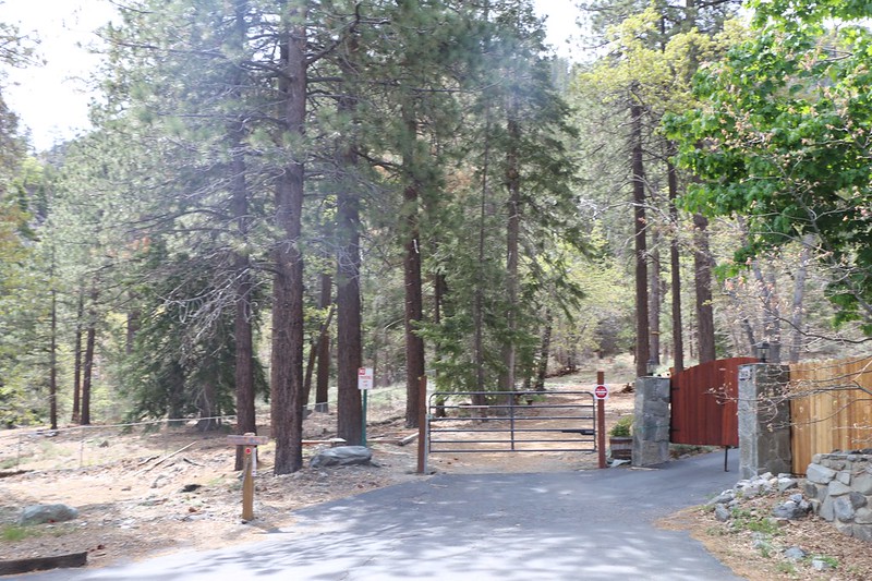
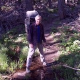
The Acorn Trail trailhead at the top of Acorn Road in Wrightwood - You'd never know there was a trail here.
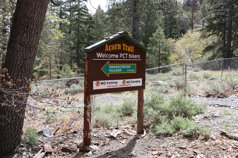
Acorn Trail trailhead - PCT Hiker Welcome to Wrightwood sign. Hikers are welcome, but with caveats...
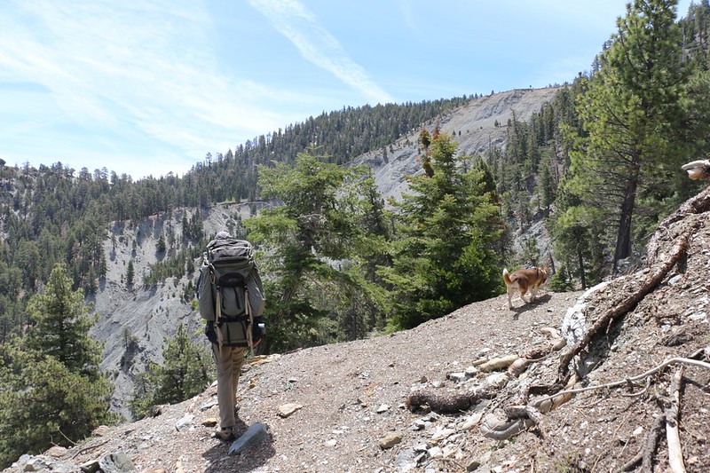
Heading up to Blue Ridge via the Acorn Trail - it's about 2000 feet of climbing in a bit over two miles
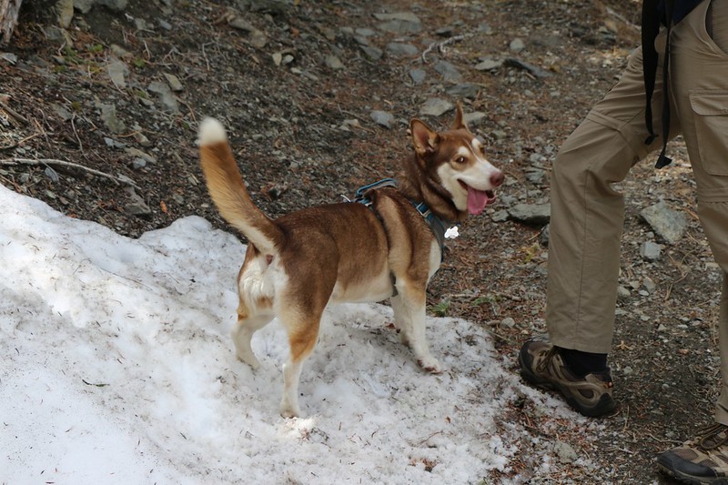
We found a residual snowdrift near the top and the dog really loved it - she's part Husky, apparently
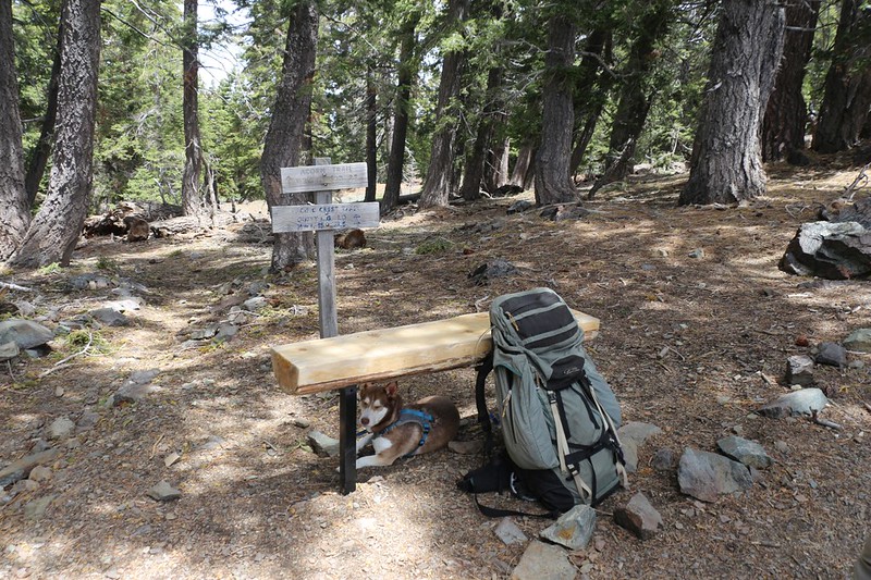
The bench and trail sign at the top of the trail where it meets the PCT
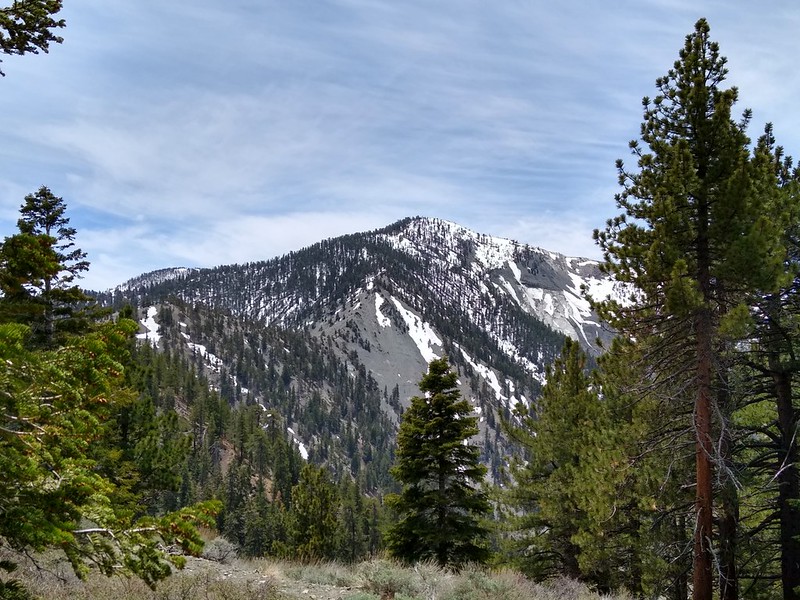
View of Pine Mountain from the top of the trail
My hiking trip reports: https://hikingtales.com/
-
Sean

- Cucamonga
- Posts: 4289
- Joined: Wed Jul 27, 2011 12:32 pm