
New fire on ACH
http://latimesblogs.latimes.com/lanow/2 ... orest.html
ACH is currently closed out of La Canada.
The Station Fire Thread


-
cougarmagic

- Posts: 1414
- Joined: Wed May 07, 2008 5:21 pm
I would think they can easily contain this between ACH and the Mt Lukens Rd, right?
-
edenooch

- Posts: 504
- Joined: Fri Jul 03, 2009 7:42 pm
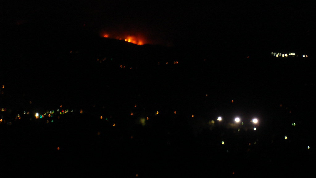
Went for a jog up the Mt lowe fire road. could see the flames.......
Even at night from echo mountain you could still see the orange glow..
water choppers like crazy..looks like its just eeast of mt lukens
Even at night from echo mountain you could still see the orange glow..
water choppers like crazy..looks like its just eeast of mt lukens
-
mattmaxon

- Posts: 1137
- Joined: Mon Mar 24, 2008 12:48 pm
Well you'd think so....cougarmagic wrote:I would think they can easily contain this between ACH and the Mt Lukens Rd, right?
LA County is probably all over this one, lots of houses on the other side of the ridge
While the weather is hot the, wind is not bad, humidity is very low as measured at clear creek teens and single digits yesterday
The brush over there is thicker than flies on a fresh one
The last fire to affect that area was the WOODWARDIA FIRE alarm date of 10/13/1959 est acreage of 14,403.3. That covered most of the Arroyo Seco bounded on the north by Angeles Crest Highway, Angeles Forest Highway, Big T rd

-
cougarmagic
- Posts: 1414
- Joined: Wed May 07, 2008 5:21 pm
I think I read that the Woodwardia fire was the last straw for the Switzer resort.

well hopefully it's out by the weekend and the road is open.Hmm...awfully close to Twin Cyn.
-
cougarmagic
- Posts: 1414
- Joined: Wed May 07, 2008 5:21 pm
from Inciweb:Highway 2 is expected to remain closed through at least noon Thursday due to firefighting operations.
http://inciweb.org/incident/1856/
(Inciweb now has a twitter feed too...that's just kind of weird....)
-
mattmaxon
- Posts: 1137
- Joined: Mon Mar 24, 2008 12:48 pm
I hiked up to Mt Lukens road and had a peek
It appeared to me the majority of the fire was below ACH in Dark Cyn, I couldn't see down the highway so I don't know what the heck was going on down there.
There wasn't much activity except for a CalFire plane orbiting, though as I was leaving some hand crews where down on the highway
I just uploaded the video (11:20am) so it is still processing
http://www.youtube.com/watch?v=BbiREHAMd5Q
-
cougarmagic
- Posts: 1414
- Joined: Wed May 07, 2008 5:21 pm
Thanks Matt. How 'bout a map showing where you were standing - I'm having trouble picturing what direction you're looking, and what ridge exactly.
Are you sure it was burning below ACH?? Oh man that is bad news...
Are you sure it was burning below ACH?? Oh man that is bad news...
-
cougarmagic
- Posts: 1414
- Joined: Wed May 07, 2008 5:21 pm
Nevermind, I got it. I also figured out why I though it was on the Lukens side - "1 mile above Angeles Crest Fire Station". I saw the word "above" and thought "uphill", rather than just north...
Image from Ch 7 (I can't figure this out exactly - I don't know what direction they're looking, if this was taken last night or early this morning.)

Image from Ch 7 (I can't figure this out exactly - I don't know what direction they're looking, if this was taken last night or early this morning.)
-
mattmaxon
- Posts: 1137
- Joined: Mon Mar 24, 2008 12:48 pm
cougarmagic wrote:Thanks Matt. How 'bout a map showing where you were standing - I'm having trouble picturing what direction you're looking, and what ridge exactly.

Positivecougarmagic wrote:Are you sure it was burning below ACH?? Oh man that is bad news...
-
cougarmagic
- Posts: 1414
- Joined: Wed May 07, 2008 5:21 pm
You were flirting with danger.... 
cbs2 is reporting that the fire has now reached the Mt Lukens ridge. They're trying to stop it there.
cbs2 is reporting that the fire has now reached the Mt Lukens ridge. They're trying to stop it there.
-
mattmaxon
- Posts: 1137
- Joined: Mon Mar 24, 2008 12:48 pm
Danger is my middle namecougarmagic wrote:You were flirting with danger....
cbs2 is reporting that the fire has now reached the Mt Lukens ridge. They're trying to stop it there.
Seems to me that it was intentional (the fire has now reached the Mt Lukens ridge)
There was no serious effort to put this out when I was there, very laid back
I wasn't surprised to see it roar back to life
At the time I was there it wasn't anywhere near Mt Lukens Rd, the ridge or much above the highway
Though I don't put much stock in anything the media sez, especially when it comes to geography.... It's a miracle they find their way out of the station let alone to the various locations IMO
Shut off the sound and hopefully they'll show something useful
The quality of the reporting is low low low

-
Taco

- Snownado survivor
- Posts: 6211
- Joined: Thu Sep 27, 2007 4:35 pm
I've seen him rappel with TWO chainsaws... into a pool full of molten-steel sharks.
-
edenooch
- Posts: 504
- Joined: Fri Jul 03, 2009 7:42 pm
went fora jog around mt washigton. looks like its east of glendale now.. chey chase canyon???
The 3 bright lighhts are the Eagle rock high Football field
The 3 bright lighhts are the Eagle rock high Football field

-
cougarmagic
- Posts: 1414
- Joined: Wed May 07, 2008 5:21 pm

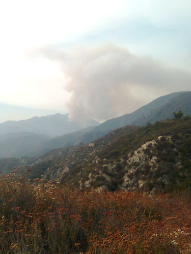
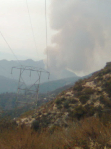
CCC ridge and Dark Canyon on the right of the frame. This was taken around noon this morning.
On the bright side - less brush on the Twin Canyon Trail! But if it gets into the canyon, that is going to be a very very sad day.

-
AlanK

- Posts: 1069
- Joined: Thu Sep 27, 2007 9:28 pm
From our street near the Verdugos we can see the flames from the Station fire shooting up over the ridge above La Canada. We just took in some La Canada friends who were asked to voluntarily evacuate from their place off of ACH near the golf course. Rumors of a quiet little fire are over.
-
Hikin_Jim

- Posts: 4688
- Joined: Thu Sep 27, 2007 9:04 pm
Not good. My mom lives right on the La Canada/La Crescenta boundary -- way up in the hills.AlanK wrote:From our street near the Verdugos we can see the flames from the Station fire shooting up over the ridge above La Canada. We just took in some La Canada friends who were asked to voluntarily evacuate from their place off of ACH near the golf course. Rumors of a quiet little fire are over.
-
mattmaxon
- Posts: 1137
- Joined: Mon Mar 24, 2008 12:48 pm
Sadly this fire has gone loco
They have a "mandatory" evacuation order is in effect for 500+ homes North of Vista Del Valle Road, East of La Canada Blvd., extending into La Canada Country Club area.
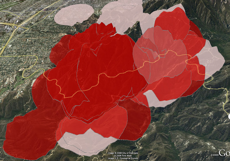
On the bright side these Modis fire detections are not all that accurate, the "footprint" is overly broad, I wouldn't read much into it, it's just and indication something is burning from a satellite 22,200 miles up
Wait for a perimeter before you start counting your losses
I'd expect Los Angeles County to become heavily involved since PP is now threatened, many more air and ground resources, which is what should have been done yesterday early instead of waiting until 9am to get out there!
My GIS data is here
http://mattmaxon.homeip.net/data/Fire%2 ... on%20Fire/
They have a "mandatory" evacuation order is in effect for 500+ homes North of Vista Del Valle Road, East of La Canada Blvd., extending into La Canada Country Club area.
On the bright side these Modis fire detections are not all that accurate, the "footprint" is overly broad, I wouldn't read much into it, it's just and indication something is burning from a satellite 22,200 miles up
Wait for a perimeter before you start counting your losses
I'd expect Los Angeles County to become heavily involved since PP is now threatened, many more air and ground resources, which is what should have been done yesterday early instead of waiting until 9am to get out there!
My GIS data is here
http://mattmaxon.homeip.net/data/Fire%2 ... on%20Fire/
-
Taco
- Snownado survivor
- Posts: 6211
- Joined: Thu Sep 27, 2007 4:35 pm
Holy shit! So those circles are generously sized?
I too could see this fire from my house.
NOT COOL
Sucks too that three major roads are now in trouble: ACH, R39, and GMR.
I hope everyone here is good to go, and doesn't have anyone in trouble near the fires.
I too could see this fire from my house.
NOT COOL
Sucks too that three major roads are now in trouble: ACH, R39, and GMR.
I hope everyone here is good to go, and doesn't have anyone in trouble near the fires.
-
mattmaxon
- Posts: 1137
- Joined: Mon Mar 24, 2008 12:48 pm
I was going to do my Friday morning thing....
Nope the smoke is very thick...around here
I thought if I went east of the fire ug worse
So I went to Big-T and headed up nope shit loads of smoke up there too.
The ER rooms will be PACKED with breathing troubles today, people will die IMO
Anybody down by the coast on the board? Was thinking of heading over toward Malibu or Ventura What's the smoke situation over there?
-
mattmaxon
- Posts: 1137
- Joined: Mon Mar 24, 2008 12:48 pm
-
cougarmagic
- Posts: 1414
- Joined: Wed May 07, 2008 5:21 pm
Holy Hell.
One news report this morning said there is now a forest-wide closure. Haven't been able to confirm that, though.
One news report this morning said there is now a forest-wide closure. Haven't been able to confirm that, though.
-
mattmaxon
- Posts: 1137
- Joined: Mon Mar 24, 2008 12:48 pm
YesTacoDelRio wrote:Holy shit! So those circles are generously sized?
I'd be inclined to say from experience watching these things, the fire is down to Arroyo Seco and up to the ridge line on Mt Lukens from Dark Cyn down canyon
Given the evacuation order and what I saw this AM it has rounded the South east ridge on to the south face of Mt Lukens and is heading west
One major problem today for aircraft is the smoke, ya can't see shit, further given the smoke the fire fighters will be having a tough slog... They'll be sending FF's to the hospital with breathing problems and heat exhaustion