
I organized a Mt Langley hike for the OCHC (formerly the OCHBC). This was to be a repeat of one I did last year, via (Old) Army Pass, except I've been watching the SummitPost boards and there's been just enough snow at Army Pass this summer to make it somewhat dangerous. So at the last minute I decided to re-route the trip to climb up via New Army Pass, which added mileage and elevation to the trip, but also allowed me to see some new country.
Eleven of us were in the group, and I rode up to Lone Pine with a friend in her 1990 VW Vanagon hippie wagon. This fact becomes significant later in the narrative.
I've made it a habit to produce maps of the hikes I lead for the OCHC, and the following example shows how you would diverge from the Cottonwood Lakes trail to go via New Army Pass (our route the lower one in light blue):
The weather was perfect, warm and sunny with no clouds at all. I think I was the only member of the party who had ever been to Cottonwood Lakes before, and of course it's quite breathtaking when you climb up through that wooded hillside and emerge all at once in the Cottonwood Lakes basin of meadows and lakes, with Mt Langley itself looming in the distance.
Our trail skirted the south of Cottonwood Lakes, and the plan was to make camp at Long Lake. Once we arrived at Long Lake, the best place to camp that we found was a hidden site below the trail on the north shore of a lake labeled "Lake 2" on the topo map, though one of the South Fork Lakes. So I don't know whether it's South Fork Lake 2 or Cottonwood Lake 2. I think it's too far south and west to be one of the Cottonwood Lakes.
The lake is fed by a stream that comes down from New Army Pass, where we soaked our tired feet.
Lake 2 is a small lake, but very pretty:
We lounged around in camp all afternoon, took a walk around the lake, ate dinner and got a little drunk from wine before turning in.
BTW, out of eleven hikers there were only nine sleeping bags. A father and son team only had one for some reason, and my friend with the Vanagon only realized she forgot to pack hers the night before in Lone Pine. I did the gallant thing and lent her my grotty old "summer bag" (from 1982) and a bivy sack, while I slept in blankets borrowed from the Vanagon. It never got very cold either night, and I was quite comfortable. Apparently, the father in the father/son team had a colder night, and those two decided to hike back to their car the second day to avoid another frigid night.
Monday morning we got up early and were on the trail by 7:30. After a night at 11,000 feet, getting up New Army Pass was relatively easy, despite how steep and forbidding it appeared.
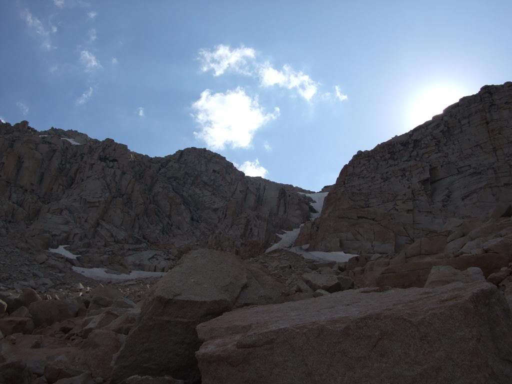
Once we emerged at the top, we experienced something you don't get to see from (Old) Army Pass: almost the entire route to the top of My Langley laid out before you:
When climbing by (Old) Army Pass, you don't really see where you are going; you just keep climbing up and up until at one point you come around some outcroppings on the flank of the mountain and see the summit for the first time. But the entire mountain is visible from the top of New Army Pass, including most of the route up. It appears from this vantage to be incredibly steep and long, and if I hadn't done it the year before I would have questioned whether we would be able to summit that day. But I guess that's an illusion caused by foreshortening in the clear mountain air.
At this point the first thing you do is head down to the top of (Old) Army Pass. This is one of the disadvantages of this route, because New Army Pass is 300 feet higher than (Old) Army Pass, so you have to lose those 300 feet to get down to the latter. And of course, you have to do the same thing on your way back, so in total New Army Pass costs you 600 feet of extra elevation gain compared to (Old) Army Pass.
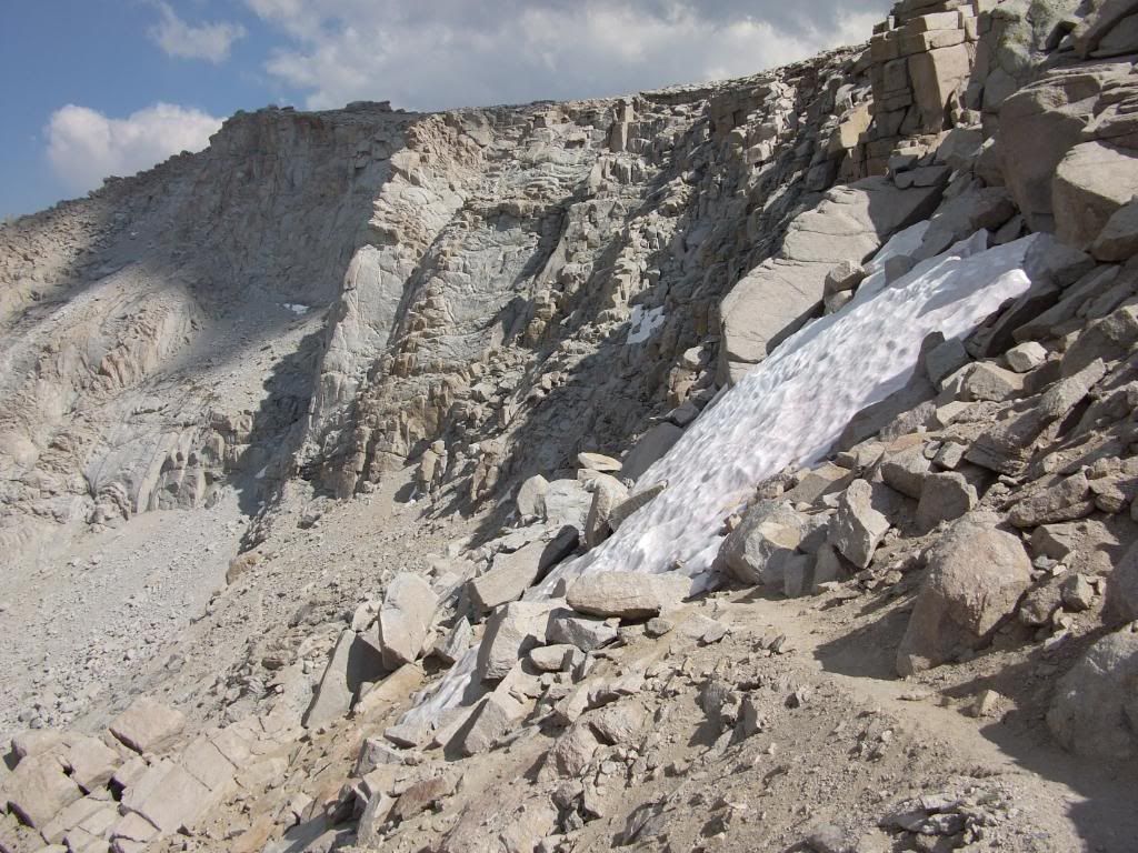
There is no trail between the two passes. Instead, we headed down the trail to Rock Creek for a while until it diverged from the bearing to (Old) Army Pass, then stepped off the trail and crossed overland to the top of the pass. I didn't like doing this, because you inevitably tread upon lots of tiny alpine plants that probably don't grow very fast. It's a shame (Old) Army Pass is no longer maintained, because that means the Park Service will never cut a trail between the two passes, and as climbers continue to use New Army Pass to get to the top of Langley, they will also trample a lot of slow-growing plants on their way up.
Anyway, the (Old) Army Pass ramparts were as impressive as they were the year before:
The top of (Old) Army Pass is at about 12,000 feet, so only 2,000 feet of elevation gain to go!
As we hiked the relatively easy traverse up the flank of the mountain, we saw some bighorn sheep far below the trail. I took a few photos of them, but you can't see much unless you look carefully at the full sized image.
The group was pretty spread out, and as usual I was walking sweep, so I was separated from most of the other climbers. The "trail" gets pretty indistinct during a steep section below what I call the "rock wall," but everyone seemed to find their way okay. Finally we emerged at the "flat rock," a little ridge just before the "rock wall" where you can plan your route to the top.
Last year our climb leader seemed to get a bit lost at this point and he led us far to the right until it was clearly too steep to go on. I was a participant in a small mutiny that time, and I insisted we go back to seek the trace trails along the left side. This year the main trace trail to the top was clearly visible, and I was relieved, as I came up to the "flat rock," to see my teammates high in the distance navigating perfectly up the most direct and easiest route through the "rock wall."
At this point the "trail" is a sandy scramble through boulders and scree, and since you are above 13,000 feet, it would be rough going in any case. It's the toughest part of the climb, and makes Langley a far more challenging climb than Whitney. But finally the summit came into view.
One of the party asked me to go on without him, and he said he would go as far as he could and then stop and wait for us to to come back down, so the summit portrait only shows ten of us:
But then 30 minutes later the final climber came plodding up to the summit to join us.
This reminded me of something Fritz mentioned to me prior to our Mt Rainier climb: that high elevation climbing is all mental. Probably most people in reasonable physical condition could do it, the only thing that would keep them back would be mental exhaustion. But the fact is, it's just a long hard walk. If you don't stop walking, you will eventually run out of mountain to walk on and you will have summited. It's almost as simple as that.
We spent a lot of time at the summit. It was very nice (if a little windy), and since we were camped less than six miles away we were in no hurry to get back down. Finally we headed back, as one of our party seemed to be suffering from the altitude.
At the top of (Old) Army Pass, we saw two backpackers who came up from Rock Creek heading down the pass. A few minutes later they reappeared and asked us the way to New Army Pass. Apparently the snow on the trail was too much for them to risk. We all started up the slope until we came to the trail and then switchbacked up the trail to the top of the pass, where the views were spectacular.
Here you can see, from foreground to background, High Lake, Long Lake, then the lake where we were camped and the rest of the South Fork Lakes:
The trail goes right past the Long Lake trail camp, which we didn't see the first day because we didn't continue far enough along the trail. It's a very nice trail camp among some tall trees by the shore of the lake, at the base of the beetling ramparts of New Army Pass:
Next time I come this way I will stay there.
I stayed with the sick hiker on the trail, so finally got into camp at 6:00pm, some time after most of the others. We spent some ten and a half hours in the high altitude sun, since there was no shade available once we left camp that morning, and I think that more than the sore feet was what left me drained and happy to be back in camp.
We "slept in" the next morning at the request of one of the hikers, who was unhappy about having to get up early for the summit climb, and finally got back to the Horseshoe Meadow trailhead around lunchtime. The rest of the team bought me lunch at the Mexican place in Lone Pine, and then everyone dispersed.
However, while gassing up the Vanagon for a planned drive up to White Mountain, I noticed grease coming out of the right front wheel. We had lost a bearing seal on the way down the mountain. We took the car to one of two mechanics in town, and he said he could replace the front seals by the next morning. So we got a couple of motel rooms and spent another night in Lone Pine, which wasn't exactly a disaster for me since I love that little town and walking around in the mellow night air was pleasant and refreshing.
We picked up the van at 11:00am and headed out of town. Somewhere on Highway 14 between Ridgecrest and Mojave, the van gave up the ghost. It stopped running and wouldn't start. We had no idea what was wrong. After arguing with AAA over whether the van was an RV or a van, we waited two hours in the 100 degree desert for a tow truck. We were saved by cell phones, an ice chest full of cool drinks and a refreshing desert breeze.
We decided the only option we had at this point was to tow the van 160 miles back to Orange County, so we ended the trip by spending three hours in the cab of a Ridgecrest tow truck with Todd the driver.
Moar photos (uncaptioned at this point).
Moar Mt Langley: 16-18 August 2009
-
Rumpled
- Posts: 271
- Joined: Mon Feb 25, 2008 10:57 pm
Nice trip report, I think I'd like to get in that area - maybe next year.....
So, last ride in a hippie van?
What was the final outcome on the van?
So, last ride in a hippie van?
What was the final outcome on the van?
-
lilbitmo

- Posts: 1092
- Joined: Tue Mar 04, 2008 9:44 pm
Well that was a Trip and then again that was a "Trip" 
Nice narrative, great pictures, congrats on getting everyone to the summit.
Were you able to convert Todd the Tow Truck Driver into a hiker?
Did he have all his teeth?
Next time you go make the guy that's complaining about the early start to get up at 4AM and make breakfast for the rest of the group, so they can start even earlier. Only a knucklehead would have complaints in that beautiful place.
Nice Work - sorry about all the CAR/Van/RV problems, only Triple AAA would give you crap about type of vehicle - hopefully you had Triple AAA "Plus" which get's you the longer tow's at no extra cost? That must of been one hell of a bill?
-
Zach

- Posts: 522
- Joined: Sun Jan 04, 2009 4:25 pm
Caught @ Lake 5 about 3 weeks ago:
My buddy said it tasted better than any trout he's ever had.
My buddy said it tasted better than any trout he's ever had.

-
friendowl

- Posts: 137
- Joined: Fri Sep 28, 2007 9:23 am
long lake trail camp is a great place to camp
-
Ze Hiker

- Posts: 1432
- Joined: Mon Jul 28, 2008 7:14 pm
nice TR
if you want to dayhike from Horshoe Meadows (thinking of doing Cirque Peak in a few weeks) do you need a permit?
If I want to sleep in my car, will I get away with parking my car at the trailhead without an overnight camping permit?
if you want to dayhike from Horshoe Meadows (thinking of doing Cirque Peak in a few weeks) do you need a permit?
If I want to sleep in my car, will I get away with parking my car at the trailhead without an overnight camping permit?
-
simonov

- Posts: 1108
- Joined: Tue Nov 27, 2007 5:44 pm
- Location: Reno, NV
Even though you cross into two Wilderness areas and one National Park, permits are not required for day hikes: http://www.fs.fed.us/r5/inyo/faq/#wpermitsZé wrote:if you want to dayhike from Horshoe Meadows (thinking of doing Cirque Peak in a few weeks) do you need a permit?
You can camp at Horseshoe Meadow, which is adjacent to the trailhead, no reservations required, $6 per night (exact change): http://www.fs.fed.us/r5/inyo/recreation ... unds.shtmlZé wrote:If I want to sleep in my car, will I get away with parking my car at the trailhead without an overnight camping permit?
Nunc est bibendum
-
Hikin_Jim

- Posts: 4688
- Joined: Thu Sep 27, 2007 9:04 pm
I noticed that OCHBC changed to OCHC a few weeks ago. What's up with that? Have they disowned backpacking? 
I guess it is a lot easier to say.
NICE photos by the way.
I guess it is a lot easier to say.
NICE photos by the way.
-
Bill

- Posts: 332
- Joined: Thu Jul 24, 2008 6:09 pm
Excellent TR as usual! 8)
I am planning a trip to Mt Whitney via Horshoe meadow, New army pass, Rock creek etc. Anyway, I noticed on your report you passed a group heading up from Rock creek to Army pass. I was thinking of heading across New army pass to Army pass and down to Rock creek via Soldier lakes. Do you know if that is a worthwhile short cut to reach Soldier lakes, or should we just continue via New army pass. According to Paul Richins Mount Whitney guide I can save a 1 1/2 miles going this way.
Maybe we can bag Langley on our way. 8)
-
simonov
- Posts: 1108
- Joined: Tue Nov 27, 2007 5:44 pm
- Location: Reno, NV
I'm not sure what you are suggesting here.Bill wrote:Excellent TR as usual! 8)
I was thinking of heading across New army pass to Army pass and down to Rock creek via Soldier lakes. Do you know if that is a worthwhile short cut to reach Soldier lakes, or should we just continue via New army pass.
There are three ways to get to Soldier Lake from Horseshoe Meadow:
1. Via the Cottonwood Lakes Trail and (Old) Army Pass. This is the shortest route, but can only be done safely if Army Pass is free of snow. Though the Army Pass trail is unmaintained, it remains well-used and was perfectly fine last year when I was on it.
2. Via the Cottonwood Lakes Trail and New Army Pass. This is less direct than the (Old) Army Pass route, plus you climb an additional 300 feet.
3. Via the Cottonwood Pass Trail, which is probably the easiest, in terms of elevation gain, but I'm guessing (without a map handy) it's also much longer than the other two.
(Old) Army Pass and New Army Pass are only about 800 yards apart at the top. Walking down to the top of (Old) Army Pass from the top of New Army Pass takes you slightly in the opposite direction if you are heading for Soldier Lake; you'd be better off just taking the trail straight down to Rock Creek from New Army Pass. There's no advantage that I can think of to crossing over to (Old) Army Pass. I'm not sure what Paul Richins is saying here, unless the trail from New Army Pass loops and switchbacks around a lot; the trail down from the top of (Old) Army Pass seems pretty direct.
Now if you wanted to summit Langley, then it's convenient to walk over to the top of (Old) Army Pass because that's where you can pick up the summit trail. That's what we did last week.
Nunc est bibendum
-
lilbitmo
- Posts: 1092
- Joined: Tue Mar 04, 2008 9:44 pm
As of August 13th at 4PM in the afternoon, this is what's left of the only snow on the whole trail going from Cottonwood Lake #4 to the top of Old Army Pass - this is the view looking down just after crossing over ridgeline at the top of the pass and taking 20 steps - it's only 15 feet across at the most when you get to it.
And this is an up close picture of the same - not much of a challenge, should you chose to go that way.
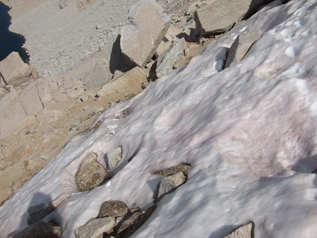
And from the botton of the pass looking up, the patch that you cross is that little section in the upper left corner of this picture, not the big stuff in the middle going up that chute.
Have fun whatever way you go up - Lilbitmo
And this is an up close picture of the same - not much of a challenge, should you chose to go that way.
And from the botton of the pass looking up, the patch that you cross is that little section in the upper left corner of this picture, not the big stuff in the middle going up that chute.
Have fun whatever way you go up - Lilbitmo
-
Bill
- Posts: 332
- Joined: Thu Jul 24, 2008 6:09 pm
Thanks for the intel Lilbitmo. I was only considering Langley, but with yours and Simonov's TR's I think we'll give it a shot! 8)