
This is the thread for place names that don't seem to be on any maps.
I am mystified by that huge mountain, quite separate from Mt San Gorgonio itself, that you see right in front of you as you come around the Sky High Trail switchbacks. It is 10,997 feet tall according to the topo map, just southeast of the Tarn. But as far as I can tell, it doesn't seem to have a name. There sure isn't any name on the topo map.
And yet it's a big mountain in its own right. If a bump on a ridge like Mt Harwood can have a name of its own, there must be a name for this peak as well.
The summit is at point A on this map.
Anyone know what it is?
Unnamed things
-
Ze Hiker

- Posts: 1432
- Joined: Mon Jul 28, 2008 7:14 pm
Sierra Club calls it Bighorn Mountain.
The one to its west is Dragons Head.
I might have switched them around though.
The one to its west is Dragons Head.
I might have switched them around though.
-
HikeUp

- Posts: 4097
- Joined: Thu Sep 27, 2007 9:21 pm
-
simonov

- Posts: 1110
- Joined: Tue Nov 27, 2007 5:44 pm
- Location: Reno, NV
Thanks.
Which bit is Dragon's Head in this photo?
Which bit is Dragon's Head in this photo?
Nunc est bibendum
-
Taco

- Snownado survivor
- Posts: 6213
- Joined: Thu Sep 27, 2007 4:35 pm
Dragon's Head is to the west. It's the one with the really really steep east face.
http://www.summitpost.org/mountain/rock ... -head.html
http://www.summitpost.org/mountain/rock ... -head.html
-
Hikin_Jim

- Posts: 4688
- Joined: Thu Sep 27, 2007 9:04 pm
The one on the left is Bighorn. The Dragon's Head is not in frame.
The "standard route" as I understand it goes to the saddle seen in your photo and then heads east up the ridge to Bighorn. I haven't been, but the view from Bighorn isn't supposed to be anything special since it's not a very apical peak. The views from the top of The Dragon's Head are supposed to be better.
HJ
-
Hikin_Jim
- Posts: 4688
- Joined: Thu Sep 27, 2007 9:04 pm
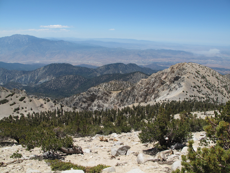
Simonov, here is a photo of the Dragon's Head shot from the Sky High Trail:
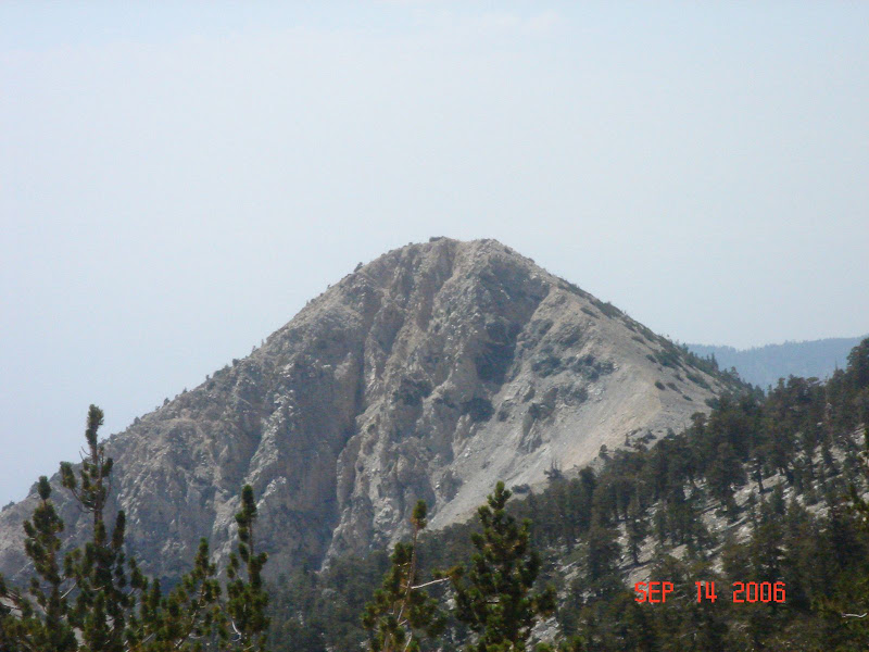
This is the summit of Bighorn Peak shot from the same area:
The USGS topo map lists Bighorn's elevation as 10,997'. However, the topo map also places San Gorgonio Mtn at 10,499' when in fact San Gorgonio Mountain's elevation has been revised upward by about 3 feet to 11,502 (rounded). Assuming that nearby Bighorn's elevation also should also be similarly revised, Bighorn's elevation would then be 11,000', making Bighorn one of only three "11'ers" in S. Calif (San Gorgonio and Jepson being the other two).
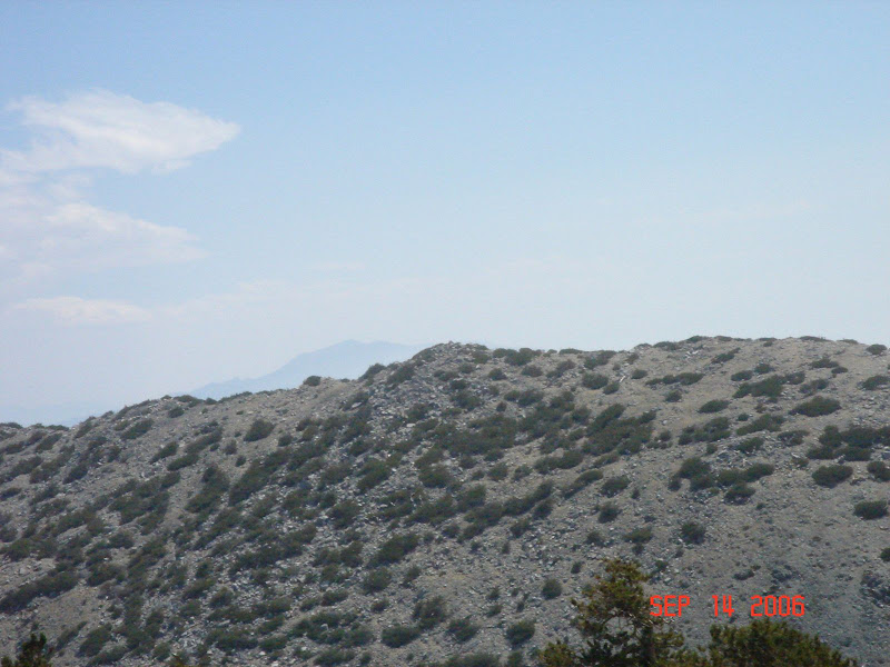
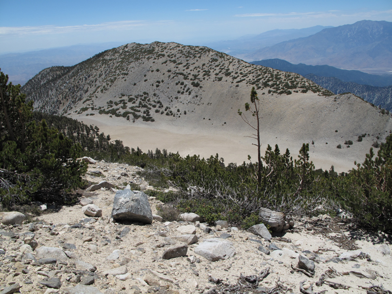
This is a photo of the western end of Tosh's Tarn and the small peak that lies between Bighorn and the Dragon's Head. If you look closely, you can see a lot of sheep trails. The standard route ascends to the saddle immediately east of this small peak and then climbs the ridge to Bighorn.
This is the summit of Bighorn Peak shot from the same area:
The USGS topo map lists Bighorn's elevation as 10,997'. However, the topo map also places San Gorgonio Mtn at 10,499' when in fact San Gorgonio Mountain's elevation has been revised upward by about 3 feet to 11,502 (rounded). Assuming that nearby Bighorn's elevation also should also be similarly revised, Bighorn's elevation would then be 11,000', making Bighorn one of only three "11'ers" in S. Calif (San Gorgonio and Jepson being the other two).
This is a photo of the western end of Tosh's Tarn and the small peak that lies between Bighorn and the Dragon's Head. If you look closely, you can see a lot of sheep trails. The standard route ascends to the saddle immediately east of this small peak and then climbs the ridge to Bighorn.
Club the clubbers?DamOTclese wrote:Death to the 'Clubbers!Zé wrote:Sierra Club calls it Bighorn Mountain.
-
Taco
- Snownado survivor
- Posts: 6213
- Joined: Thu Sep 27, 2007 4:35 pm
Tosh's Tarn? I thought it was just 'THE' Tarn. Enlighten me, Sensei Jim Kun.
-
Richard N.
- Posts: 91
- Joined: Tue Feb 12, 2008 9:47 pm
As long as I've known about the Tarn, and its only been 40+ years, its only been called the Tarn.
Someone must have just added their name to it. Like they found it or something???
I've hike there as well as Big Horn & Dragon's Head. Nothing all that spectacular.
What would be good for any hiker is to see the tarn with water in it. It really does fill up at times. Generally early spring is best.
Someone must have just added their name to it. Like they found it or something???
I've hike there as well as Big Horn & Dragon's Head. Nothing all that spectacular.
What would be good for any hiker is to see the tarn with water in it. It really does fill up at times. Generally early spring is best.
-
Hikin_Jim
- Posts: 4688
- Joined: Thu Sep 27, 2007 9:04 pm
The "Defender's of the San Gorgonio Wilderness" map (a.k.a. "the Green Map") list's it as "Tosh's Tarn". The Defender's of the San Gorgonio Wilderness is the group that saved the SGW from development as a ski resort (THANK GOD). Bob Tosh, IIRC, was a naturalist who explored the San Gorgonio Wilderness extensively in the 1960's and 1970's. I believe Tosh's work, which documented the diversity of the SGW's fragile alpine, riparian, and montane eco-systems, was used during the proceedings that eventually saved the SGW. Naming the tarn after him seems fitting.TacoDelRio wrote:Tosh's Tarn? I thought it was just 'THE' Tarn. Enlighten me, Sensei Jim Kun.
Of course, since there's pretty much only one tarn in the SGW, "The Tarn" works pretty well and is commonly used. A "tarn" is generally a glacially carved vernal pool.
So, when will we be seeing a winter ascent of the NE face of the Dragon's Head. I rate it as somewhere between "complete lunacy" and "suicide mission" on the "official" HJ scale.
HJ
-
Hikin_Jim
- Posts: 4688
- Joined: Thu Sep 27, 2007 9:04 pm
Close encounters of the DamOTclese kind?DamOTclese wrote:Huh, Dragon's Head looks like the mountain I carved out of mashed potatos last night at dinner.

-
Hikin_Jim
- Posts: 4688
- Joined: Thu Sep 27, 2007 9:04 pm
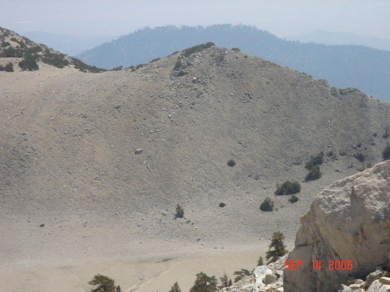
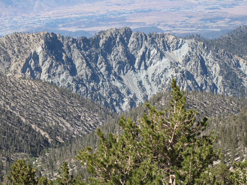
Speaking of Tosh's Tarn and the Dragon's Head, here is a photo of the Dragon's Head taken from Tosh's Tarn:

-
Taco
- Snownado survivor
- Posts: 6213
- Joined: Thu Sep 27, 2007 4:35 pm
NEF of Dragonshead might be in this winter. Not super high on the list, but hey, sure looks good. Will probably go up, camp at the tarn, and rap down or otherwise move down and grab the goods, instead of doing some mega long approach.
-
Elwood

- Posts: 627
- Joined: Fri Aug 15, 2008 5:23 pm
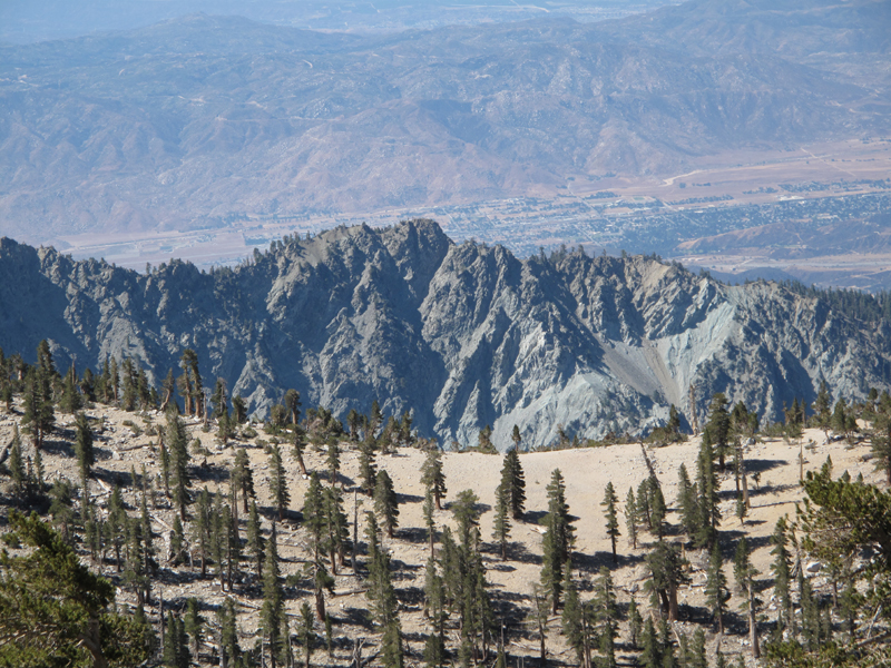
Though probably neither useful nor relevant, I snapped these pictures of this area on Saturday whilst visiting Alvin and the other Chipmunks on San Gorgonio Mountain. As an interesting aside; there were real live Rangers checking Wilderness Passes on-trail in the SGW.
Regards,
Elwood
Regards,
Elwood
-
Hikin_Jim
- Posts: 4688
- Joined: Thu Sep 27, 2007 9:04 pm
Elwood:
Cool pix. So photo #2 is of the Dragon's Head and photo #3 is of Bighorn, but what are photo #1 and #4 of? Is that the Dragon's Head shot from an angle that I just don't recognize? Or is that Yucaipa Ridge? Or ?
HJ
Cool pix. So photo #2 is of the Dragon's Head and photo #3 is of Bighorn, but what are photo #1 and #4 of? Is that the Dragon's Head shot from an angle that I just don't recognize? Or is that Yucaipa Ridge? Or ?
HJ
-
Elwood
- Posts: 627
- Joined: Fri Aug 15, 2008 5:23 pm
I'm not entirely sure. The view is looking ~SSW from the Divide Trail. My best guess it's the ridge that includes Galena and Little San 'G'.
-
Tim

- Posts: 560
- Joined: Tue Apr 08, 2008 8:55 pm
Pretty sure pics 1 and 4 are of the Yucaipa Ridge near the Galena side. I recognize Galena in pic #4 as that transition on the left side from the normal looking brown soil to that crappy, crumbly grey soil.
-
Hikin_Jim
- Posts: 4688
- Joined: Thu Sep 27, 2007 9:04 pm
OK, Yucaipa Ridge it is. Didn't think that was the Dragon's Head.