North Ridge Iron Mountain

TRs for the San Gabriel Mountains.
Post Reply
User avatar
LD
Posts: 93
Joined: Sat Jan 31, 2009 10:03 pm

Post by LD »

About 3 weeks ago as 5 of us were topping out on Iron having just completed the traverse from Mt. Baldy I mentioned to Mace “now that we’ve done Iron from 3 sides (we had done the S/W ridge in April) how about if we box Big Iron?”
“What do you mean?”
“I just made that term up; if we could do the North Ridge as a day hike it would mean we did Iron from all 4 sides, you know like a box.”
Rolling his eyes, Mace laughed and said “Sure I’m in, what’s another death march” :roll:

So I went about the Internet scouring for beta on the North Ridge only finding a few reports done as multi day hikes. I was able to get an idea of what gulley to go up but not too much on how long it would take to get to that point.
So with a preliminary topo with elevation points marked off we set off from East Fork trailhead at 5:10. It was already 65 degrees and we knew it was going to be a hot day but if we didn’t do it today we would probably have to put it off until the fall. We figured we could stay out of most of the early heat until we hit the gulley.

With only 2 stream crossings we made the bridge in 1:40 minutes. Since neither one of us had never been past the bridge the rest of the journey would be all new to us. I estimated we could be at the gulley by 10.
We were pleasantly surprised to find a pretty good use trail from the bridge to Iron Fork. We saw a few prospector camps along the way, which would explain the use trail.
We made Iron Fork by 8 and at 9 we were at the waterfall from Falls Gulch. We were going in and out of the stream by then, mainly in.

Once we started up Fish Fork the conditions changed which really slowed us down. No more use trail and if you tried to stay out of the water you would run into poison oak.
Going up stream the rocks were really slippery. They seemed to have a film of algae on top of them. You had to be careful not to slip. This wouldn’t be a good place to get injured.
It felt like we were in the jungle with overlying trees and brush shielding us from the sun and it was getting very humid being that close to the water. The water felt warm and dousing ourselves didn’t seem to help much. After 6 hours this water stuff was really getting old.

We had calibrated our altimeters at the bridge and so far they had been right on with the topo. So right at 4140’ we spotted a small opening in the trees and low and behold there was a gulley. Right or wrong we were going up it.

It took us until 11:50 to get here. A little over 6 ½ hours after we started. I was already off by 2 hours on my estimate. The water stuff had really slowed us down.

We rested here and ate and drank as much water as we could and then filled our backpacks with 6 liters each. It was 85 degrees down by the stream out of the sun and we could only imagine what it would be once we started up.

We started up the gulley at 1 and right away we ran into a large headwall. I didn’t remember reading about any headwall so I thought maybe we were going up the wrong gulley. No matter, we were committed so we started up the ridge to the right of the gulley since it was less brushy figuring we would go up a ways and then go back into the gulley and continue up. But as we continued up the gulley was looking pretty bad with brush so we just continued up the ridge working our way through the brush and deadfall. After about 500’ the ridge cleared up a bit and we eventually started to contour our way over to the gulley at the top and made the ridge at 6000’ by 4.

I had stopped about 200’ below in some shade to change into dry socks, as my shoes were almost dry by now. As I hiked up to meet Mace on the ridgeline I heard him say “you’re not going to like this.” As I looked south up the ridgeline all I could see was 1500’ of mainly class 3 climbing. This was going to be a long day.
As it turned out the class 3 was easy and ended at around 7000’. After that it was mainly class 2 with some occasional 3.

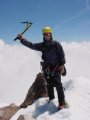
We finally topped out at 6:45. We took a 30 minute break and refueled ourselves. We were doing fine with fluids. We only ended up at the end of the day using 5 of our 6 liters, which surprised us considering the heat. Drinking up at the stream before heading up really helped hydrate us.

We zombied on down to Allison saddle where we had to put headlamps on, making it back to the truck at 11:15 for an 18 hour day.

I think we’re both done with Iron for a while.

We both agreed on this scale of difficulty:
1. North Ridge-no contest
2. S/W ridge-shorter hiking time to 4000’ and just a little class3
3. South trail (regular route)
4. East Ridge (Baldy Traverse) - 10000’ of downhill and most of gain is on Ski Hut trail

Up through the Narrows
Image

Dave's not here
Image

Iron Fork confluence
Image


Stanley Miller mine up there somewhere. More vertical then it looks here. There is a gulley to the east that looks doable
Image

Past Narrows toward Fish Fork
Image

Stalagtite Formation just before the waterfall
Image

200' waterfall
Image

Fish Fork confluence
Image

Fish Fork camp
Image

Heading up Fish Fork
Image

Fish Fork slimy rocks
Image

Iron Mt. drainage,looking downstream. Easy to miss drainages as they come together. Take a right turn here
Image

Up Iron Mt. drainage
Image

Gulley at 4140'
Image

Weaving our way to the ridge
Image

500' up the brush cleared
Image

Gulley to our left
Image

Looking down the North ridge
Image

Looking North of what we just climbed at 6000'
Image

Ross Mt and Baden Powell
Image

Looking South toward Iron
Image

Making our way thru the 3rd class
Image

Head wall at around 7300'. There is a gulley to the left to get around this
Image

Almost there. The top is 7800'
Image

The End or just the beginning to the end
Image

Image

Image
User avatar
Tim
Posts: 560
Joined: Tue Apr 08, 2008 8:55 pm

Post by Tim »

WOW, difficult route on a difficult day. Congrats! Too bad there isn't a way to get to the fun stuff (the Class 3) without that hugely long approach.
User avatar
Ze Hiker
Posts: 1430
Joined: Mon Jul 28, 2008 7:14 pm

Post by Ze Hiker »

dude, excellent job!

that's one long approach alright. i hate poison oak. seems like that section up Fish Fork really slowed you down, I wonder if one can start ascending the ridge from north of Falls Gulch...

you seem to pick the hottest days for these things, what gives ? :)

ok since you did this and Triplet Rocks, which one is worse?
User avatar
EnFuego
Posts: 677
Joined: Mon Dec 15, 2008 11:14 am

Post by EnFuego »

Wow. What an incredible hike. Nice job and great photos. Thanks for this TR.
User avatar
Elwood
Posts: 612
Joined: Fri Aug 15, 2008 5:23 pm

Post by Elwood »

I'm not worthy! I'm not worthy! Amazing trek and report. Thanks for sharing.
User avatar
Winston
Posts: 50
Joined: Wed Jun 24, 2009 1:58 pm

Post by Winston »

Great job! Love all the pics, especially those of the turn off points. Very useful!
User avatar
LD
Posts: 93
Joined: Sat Jan 31, 2009 10:03 pm

Post by LD »

wrote:dude, excellent job!

that's one long approach alright. i hate poison oak. seems like that section up Fish Fork really slowed you down, I wonder if one can start ascending the ridge from north of Falls Gulch...


you seem to pick the hottest days for these things, what gives ? :)

ok since you did this and Triplet Rocks, which one is worse?
Thanks Ze. I'm real sensitive to poison oak also. The last four times I've got it I've had to go to the doctor for a steroid shot to knock it down. I already have a rash forming on my calf,so does Mace. I was stupid not to have brought my Technu. And I'm supposed to go to Vegas with the wife this weekend. She ain't gonna like that :x
That section in Fish Fork sucked. Slippery rocks and deadfall across the stream. Poison Oak all around making us paranoid looking at every leaf :x

I was looking down Falls Gulch thinking the same thing. It looked possible to climb to the right of the waterfall and gain access to Falls Gulch. It definitely looked a lot less brushy then the other side of the ridge. The picture looking north down the ridgeline is what Falls Gulch looks like. Certainly would kill some milage. I guess you need to do a recon when you check out Stanly Miller :lol:

We don't plan on these hot days for sure. Just been our bad luck. Sometimes I don't have a choice on weekends(work) so it's go at the last moment or put it off. These types of hikes need a lot of daylight so that pretty much puts you right in the summertime. But I'll say I have learned a lot about my body and how it reacts to heat and long days.Makes me a safer hiker in the long run. As Mountain Impulse said this is a very commiting hike. Not much choice of turning around.

Triplet. How did I know you would ask me that? :wink:
We would pick Triplet but not by much mainly because with Triplet you need to carry all your fluids where here you could hydrate up before climbing.
Also navigation on Triplet much harder especially as you get closer to Triplet. This one's fairly easy once you find the right ridge to go up.

So which one first for you? :wink:

P.S. Mace and I still have to do Cow Canyon to start boxing in Baldy. It's gonna be nice to have your TR to reference. Thanks :)
User avatar
lilbitmo
Posts: 1092
Joined: Tue Mar 04, 2008 9:44 pm

Post by lilbitmo »

Nice TR LD, that's outstanding, great pict's and great BETA - now watch Rick Kent go out and do all four sides in one day - just kidding.

That was one hell of a day.

Nice work.

If I enter a state that has poison oak it will find me, so I know the feeling, I got it on my N#$ Sack (the week before) my wedding, the wife was not happy, all she could do was laugh at me.

Hopefully it will go away quickly.

Good luck with that. :lol:
User avatar
outwhere
Posts: 323
Joined: Sun Jan 25, 2009 5:40 pm

Post by outwhere »

lilbitmo wrote:I got it on my N#$ Sack (the week before) my wedding, the wife was not happy, all she could do was laugh at me.
Lilbitmo,

Well I just don't get it --- if you got poison oak on your nap sack why didn't your wife just go buy you a new one instead of laughing at you? :P

That's an amazing TR, LD! Great one all the way around...!
User avatar
406
Posts: 316
Joined: Thu Jan 17, 2008 10:36 am

Post by 406 »

nice work
User avatar
cougarmagic
Posts: 1409
Joined: Wed May 07, 2008 5:21 pm

Post by cougarmagic »

Good job!! I really enjoy reading these big trip reports. I love the spirit of exploration in general, but especially when it comes to "our" mountains. Also, though the water is tough to slog thru, it is a beautiful sight in the summer...

Too bad about the PO - I've been using Ivy Block lotion, and have been poison oak free for about a year now. (for a while there, it seemed like I had a patch of it somewhere, all the time, and steroids make me feel awful) I truly believe in the stuff. It's a lotion made of clay, basically - coats you with a thin layer so the oil never touches your skin

That pic of the stalactite - its the sword of DamOTclese! :lol:
User avatar
Rick Kent
Posts: 150
Joined: Tue Oct 02, 2007 11:21 am

Post by Rick Kent »

Very cool! That had to be pretty tough and yet you guys pulled it off. Nice work!
User avatar
Ze Hiker
Posts: 1430
Joined: Mon Jul 28, 2008 7:14 pm

Post by Ze Hiker »

LD wrote: Thanks Ze. I'm real sensitive to poison oak also. The last four times I've got it I've had to go to the doctor for a steroid shot to knock it down. I already have a rash forming on my calf,so does Mace. I was stupid not to have brought my Technu. And I'm supposed to go to Vegas with the wife this weekend. She ain't gonna like that :x
That section in Fish Fork sucked. Slippery rocks and deadfall across the stream. Poison Oak all around making us paranoid looking at every leaf :x

I was looking down Falls Gulch thinking the same thing. It looked possible to climb to the right of the waterfall and gain access to Falls Gulch. It definitely looked a lot less brushy then the other side of the ridge. The picture looking north down the ridgeline is what Falls Gulch looks like. Certainly would kill some milage. I guess you need to do a recon when you check out Stanly Miller :lol:

We don't plan on these hot days for sure. Just been our bad luck. Sometimes I don't have a choice on weekends(work) so it's go at the last moment or put it off. These types of hikes need a lot of daylight so that pretty much puts you right in the summertime. But I'll say I have learned a lot about my body and how it reacts to heat and long days.Makes me a safer hiker in the long run. As Mountain Impulse said this is a very commiting hike. Not much choice of turning around.

Triplet. How did I know you would ask me that? :wink:
We would pick Triplet but not by much mainly because with Triplet you need to carry all your fluids where here you could hydrate up before climbing.
Also navigation on Triplet much harder especially as you get closer to Triplet. This one's fairly easy once you find the right ridge to go up.

So which one first for you? :wink:

P.S. Mace and I still have to do Cow Canyon to start boxing in Baldy. It's gonna be nice to have your TR to reference. Thanks :)
PO is terrible. I got a really bad case earlier this year for doing spontaneously doing some major bushwhacking up in the Bay area. 2 nights I couldn't sleep, yikes! So I feel your pain, damn!

Yeah avoiding Fish Fork looks tempting. I'm planning on hiking up to Stanley miller in maybe 3 weeks or so. Planning on checking out routes up NW to Iron, Falls Gulch route, and some other probably bad ideas in the area.

Tough hikes are difficult to sort out, so much depends on the exact day, whether its a first time ascent or not. Big Horn ridge is the toughest I've done I have to say. I didn't do Triplets all the way, as you know (though did the elevation gain). East twin SE ridge was easier to navigate, less brush, but more rugged.

Big Horn ridge probably could end up not being that bad (aside from the 7500+ gain) if the optimal path is chosen, so repeated trips would be easier. Using a previous TR helps though.

meh, they're all terrible :D
User avatar
AW~
Posts: 2036
Joined: Mon Oct 01, 2007 12:00 pm

Post by AW~ »

Falls Gulch wouldnt be a standard route...easy enough to see for oneself though. The crux move into the gulch from above the waterfall, I wouldn't attempt(without a rope) during dry months...the support 'ledge' I recall is about 1/2 a foot wide, 1.5ft in length on soil(hands first and about 100ft of high angle exposure). Theres also an easier up and around the obstacle thats done upstream(assuming no pack toss is used) then the next waterfall one easily enough gains the ridge brushfree...however I remember it(that second move) curiously going through the one poision oak in the gulch...most of that part of the gulch is clear and pretty.

Image
User avatar
AW~
Posts: 2036
Joined: Mon Oct 01, 2007 12:00 pm

Post by AW~ »

forgot to mention what a trip and thanks for the pictures LD...saved me a trip to Fish Fork for sure. So whats next? West ridge Twin!, West ridge Twin!...hehehe...I'll settle for Little Mermaid Pk?!
User avatar
LD
Posts: 93
Joined: Sat Jan 31, 2009 10:03 pm

Post by LD »

AW wrote:forgot to mention what a trip and thanks for the pictures LD...saved me a trip to Fish Fork for sure. So whats next? West ridge Twin!, West ridge Twin!...hehehe...I'll settle for Little Mermaid Pk?!
Thanks AW, that climb around the waterfall did look somewhat hairy without pro. I didn’t know there was another waterfall up stream of that though. It looks like a person wouldn’t save much time going that way then.
When did you go up there and do you have more picts of that gulch? How far did you go?

Getting to be Sierra season now. It’ll be nice not having to carry so much water with me.
We may do Triplet again in September. I think I can find a different way down by the bottom to save some time.

You got me curious. What is this west ridge?
Rick Kent wrote:Very cool! That had to be pretty tough and yet you guys pulled it off. Nice work!
Thanks Rick. Reading from your epic deathmarches this would be right up your alley.

Thanks Cougermagic.....I don't know how both of us got PO on our calves since we both had long pants. Does PO oil float on top of the water? That's the only way we would have got I think. If so that really sucks for me in the future though I'll for sure try that Ivy Block lotion.
lilbitmo wrote: If I enter a state that has poison oak it will find me, so I know the feeling, I got it on my N#$ Sack (the week before) my wedding, the wife was not happy, all she could do was laugh at me.

Hopefully it will go away quickly.

Good luck with that.
If all she did was laugh you must be newlyweds :D
User avatar
Taco
Posts: 5999
Joined: Thu Sep 27, 2007 4:35 pm

Post by Taco »

Here's a challenge for any of you. If any of you pull it off, it'll be cool. If you go ropeless, even more challenging, though not as safe.

Central Mermaid Peak. Highest point just west of Little Mermaid Peak 3702 right in the middle of the SG Wilderness.

Go.
User avatar
lilbitmo
Posts: 1092
Joined: Tue Mar 04, 2008 9:44 pm

Post by lilbitmo »

LD replied
lilbitmo wrote:

If I enter a state that has poison oak it will find me, so I know the feeling, I got it on my N#$ Sack (the week before) my wedding, the wife was not happy, all she could do was laugh at me.

LD response was "If all she did was laugh you must be newlyweds"
Point well taken, but somethings are better left "Unspoken/Untouched" if you know what I mean :shock:
User avatar
AW~
Posts: 2036
Joined: Mon Oct 01, 2007 12:00 pm

Post by AW~ »

5 photos of Falls Gulch 2 years ago:
http://www.flickr.com/photos/13833920@N03/page2
1) Looking upcanyon just upstream of dropin/crux move
2) next waterfall, hill on canyon left before falls is brushfree hike to ridge and beyond
3)exit waterfall
4)smaller falls dotting the gulch, as pic#1 shows easy bypasses
5) obstacle#2

West ridge Twin Peaks peak 5014.....pretty place(at least the views from afar I have seen), long approaches from all directions. Rugged territory. Ze? :D

Mermaid peaks are the like the prehikes to west ridge if attempted from the bottom...best done in the winter with the snow capped mountains above. Doesnt require a rope...does require 'weaving' the terrain though oh and some kind of strong hiking stick or trekking poles for Mermaid draw...it be steep.
User avatar
Ze Hiker
Posts: 1430
Joined: Mon Jul 28, 2008 7:14 pm

Post by Ze Hiker »

sure let's check it out sometime. recon trying to go down from ACH, at least that's my preference right now. easy car shuttle

those are nice pics of Falls Gulch. looks like a cool area to see at least.
User avatar
Hikin_Jim
Posts: 4686
Joined: Thu Sep 27, 2007 9:04 pm

Post by Hikin_Jim »

AW wrote:5 photos of Falls Gulch 2 years ago:
http://www.flickr.com/photos/13833920@N03/page2
1) Looking upcanyon just upstream of dropin/crux move
2) next waterfall, hill on canyon left before falls is brushfree hike to ridge and beyond
3)exit waterfall
4)smaller falls dotting the gulch, as pic#1 shows easy bypasses
5) obstacle#2

West ridge Twin Peaks peak 5014.....pretty place(at least the views from afar I have seen), long approaches from all directions. Rugged territory. Ze? :D

Mermaid peaks are the like the prehikes to west ridge if attempted from the bottom...best done in the winter with the snow capped mountains above. Doesnt require a rope...does require 'weaving' the terrain though oh and some kind of strong hiking stick or trekking poles for Mermaid draw...it be steep.
DANG good looking photos and right in our back yard. Some of that beautiful stuff is around 15 minutes from my place (well, the trailhead is). Amazing what's there that but a few know about. I guess that's the greatest delight of the San Gabriels: you never know what fabulous nook is just around that corner; so many undiscovered places.
User avatar
LD
Posts: 93
Joined: Sat Jan 31, 2009 10:03 pm

Post by LD »

Oh, :shock: that West Ridge
AW wrote:forgot to mention what a trip and thanks for the pictures LD...saved me a trip to Fish Fork for sure. So whats next? West ridge Twin!, West ridge Twin!...hehehe...I'll settle for Little Mermaid Pk?!
Would you settle for going up to peak 6649 and then twin. Seems a little closer then that route to peak 5041. You know that area better then me. I have no idea what either ridge line looks like but whichever has less brush is the one for me.

Image
User avatar
AW~
Posts: 2036
Joined: Mon Oct 01, 2007 12:00 pm

Post by AW~ »

that place is horribly rugged...I think what Ze is referring to is going down Skull canyon...
http://www.dankat.com/advents/maps/dvloop.htm

but then what? and to meet the challenge it has to be pk 5014...its the most noticable one with the exposed solid rock face. Every way is challenging, every way out the same.
User avatar
Taco
Posts: 5999
Joined: Thu Sep 27, 2007 4:35 pm

Post by Taco »

It would be badass to do that in cooler weather.
Post Reply