
Buck Point and San Sevaine Lookout
I am planning on hiking these 2 peaks soon. Anyone know if the road is open to drive to them from the I-15. Anyone aware of alternative (aka more interesting) routes? It looks like it would be a good hike to Buck Point from Icehouse Canyon over Etiwanda Peak.
http://angeles.sierraclub.org/hps/guides/17g.htm
http://angeles.sierraclub.org/hps/guides/17h.htm
thanks for any info.
San Sevaine Road (1N34)
-
Travis

- Posts: 268
- Joined: Thu Sep 27, 2007 3:04 pm
I still want to hike these peaks. There is a trip report on summitpost.
http://www.summitpost.org/trip-report/3 ... tains.html
Here is the route I am now thinking, it was mentioned in the HPS route page. Trailhead from the north end of Etiwanda Ave.
http://www.summitpost.org/trip-report/3 ... tains.html
Here is the route I am now thinking, it was mentioned in the HPS route page. Trailhead from the north end of Etiwanda Ave.
-
Taco

- Snownado survivor
- Posts: 6193
- Joined: Thu Sep 27, 2007 4:35 pm
I take it that road is non-accessible? The one running to SS Lookout?
-
Zinge

- Posts: 4
- Joined: Wed Oct 10, 2007 10:59 pm
I checked about a month or so ago and the road was gated. I've been eyeing that ridge for quite a while when driving by and it looks doable.
I've also considered just hiking up the dirt road and tagging the two, but that's no fun! Let me know if you want company in trying out that ridge.
Eric G.
I've also considered just hiking up the dirt road and tagging the two, but that's no fun! Let me know if you want company in trying out that ridge.
Eric G.
-
Travis
- Posts: 268
- Joined: Thu Sep 27, 2007 3:04 pm
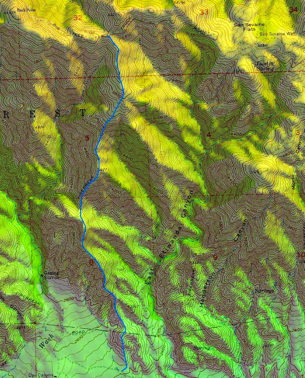
I checked it out on google earth, the ridge looks brush free (looks like the firebreak is in good condition). Check out the track (this will open in Google Earth).
http://www.class3hiking.com/buckpointgo ... htrack.kmz

http://www.class3hiking.com/buckpointgo ... htrack.kmz

-
Travis
- Posts: 268
- Joined: Thu Sep 27, 2007 3:04 pm
i gathered all the info together and put it up on my website:
http://www.gpsmountaineering.com/buckpo ... inelookout
i am hoping to do this hike next sunday, Jan. 20th.
i estimate that to hike to both Buck Point and San Servaine Lookout it would be 16.5 miles and 5500 ft elev. gain, maybe a little less if I can drive further up the dirt road.
let me know if you are interested in joining us,
-
Zinge
- Posts: 4
- Joined: Wed Oct 10, 2007 10:59 pm
Travis,
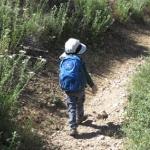
Here's a pic of the ridge:

There's a gate right where your map starts.
I would like to join with you guys, what time would you plan on starting? I'm considering tagging Etiwanda as well since after all it's right there(kinda).
But that's going to require an early start and add ~10 miles and bring the elevation gain closer to 9000ft. Plus the snow! hhhmmmm....
Here's a pic of the ridge:
There's a gate right where your map starts.
I would like to join with you guys, what time would you plan on starting? I'm considering tagging Etiwanda as well since after all it's right there(kinda).
But that's going to require an early start and add ~10 miles and bring the elevation gain closer to 9000ft. Plus the snow! hhhmmmm....
-
Travis
- Posts: 268
- Joined: Thu Sep 27, 2007 3:04 pm
We are going ahead on this hike this Sunday, 1/20/08. We will start hiking at the north end of Etiwanda Ave (at the gate) around 7 am ish (more likely 7:30). Anyone is welcome to join us, we will be hiking at a fast pace.
travis
travis
-
dhstein31
- Posts: 21
- Joined: Sat Oct 13, 2007 12:04 am
Did a very similar "route finding" hike a few years ago off of etiwanda ave adnd then up to the road to Big Tree and then over Etiwanda to Cucamonga and shuttled over to Ice House. Some interesting route finding but very doable ---- wear long pants some of that brush gets quite thick.
D
D
-
Mike P

- Posts: 1005
- Joined: Tue Oct 02, 2007 10:48 pm
Has anyone been up there lately and know the road conditions? The plan is to do Cucamonga Peak from Big Tree Trailhead.
Thanks!
Thanks!
-
tarol
- Posts: 126
- Joined: Tue Nov 06, 2007 12:28 pm
Road is in fairly good shape, high clearance vehicles strongly recommended.
-
Mike P
- Posts: 1005
- Joined: Tue Oct 02, 2007 10:48 pm
Is the road open?
Lytle Creek Ranger Station said it was closed and that no one was allowed. We ended up doing Cucamonga from the usual Icehouse Canyon direction.
Lytle Creek Ranger Station said it was closed and that no one was allowed. We ended up doing Cucamonga from the usual Icehouse Canyon direction.
-
Bill

- Posts: 332
- Joined: Thu Jul 24, 2008 6:09 pm
Just did the trip from Middlefork Lytle to Icehouse and on to Wrightwood. It was great! (TR to follow)Sorry to here someone came up missing near Icehouse.  We were at Icehouse around 11:00 a.m. on 9/24 and saw several people. None appeared lost.
Did they end up finding him? We heard the helicopter flying over us as we camped on Timber Mtn.
Did they end up finding him? We heard the helicopter flying over us as we camped on Timber Mtn.
-
FIGHT ON
No pics? no tr?Bill wrote:Just did the trip from Middlefork Lytle to Icehouse and on to Wrightwood. It was great! (TR to follow)Sorry to here someone came up missing near Icehouse.
Did they end up finding him? We heard the helicopter flying over us as we camped on Timber Mtn.
-
Taco
- Snownado survivor
- Posts: 6193
- Joined: Thu Sep 27, 2007 4:35 pm
(TR to follow)FIGHT ON wrote:No pics? no tr?Bill wrote:Just did the trip from Middlefork Lytle to Icehouse and on to Wrightwood. It was great! (TR to follow)Sorry to here someone came up missing near Icehouse.
Did they end up finding him? We heard the helicopter flying over us as we camped on Timber Mtn.
-
Taco
- Snownado survivor
- Posts: 6193
- Joined: Thu Sep 27, 2007 4:35 pm
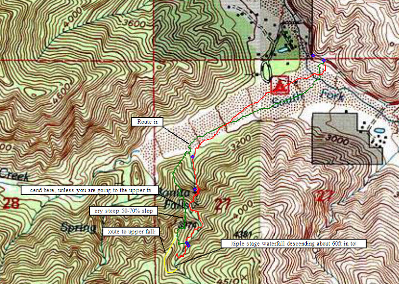
Cucamonga Truck Trail, right? Is it open up that far? We're going to do some canyoneering down Bonita Falls.
-
HikeUp

- Posts: 4070
- Joined: Thu Sep 27, 2007 9:21 pm
That'd be road 1N34 I think. Supposed to be closed except during the fall I believe (map below from the ranger station says it is open Labor Day thru January). The gate just a few yards off of Lytle Creek Road was locked a few weeks ago. The Lytle Creek Ranger Station will know if you give em a ring (if you dare).

-
AW~

- Posts: 2110
- Joined: Mon Oct 01, 2007 12:00 pm
Even easier is to follow more up-to-date beta.Zé wrote:just hike up Etiwanda ridge. much easier
http://canyonbeta.com/2010/01/bonita-canyon/
I think the elevation gain is considered 500ft.
-
Ze Hiker

- Posts: 1432
- Joined: Mon Jul 28, 2008 7:14 pm
i was kidding!AW wrote:Even easier is to follow more up-to-date beta.Zé wrote:just hike up Etiwanda ridge. much easier
http://canyonbeta.com/2010/01/bonita-canyon/
I think the elevation gain is considered 500ft.
-
mattmaxon

- Posts: 1137
- Joined: Mon Mar 24, 2008 12:48 pm
Watch your rope pull on the last rap, and have the first man down carry the rope, there are generally lots of people at the bottom of the fallsTacoDelRio wrote:Cucamonga Truck Trail, right? Is it open up that far? We're going to do some canyoneering down Bonita Falls.
They don't know to get out of the way.
That route up may be getting a bit brushy now...
Matt
-
T McPherson
- Posts: 17
- Joined: Thu Aug 25, 2011 10:30 am
As of 9-11-11 1N34 is open to Joe Eliot Tree Memorial Campground from Lytle Creek Rd. I did not discover that it was open until this afternoon. I grabbed something to drink and took my Jeep up about 3.5 miles to a scenic view above Coyote Canyon which eventually sheds into Etiwanda flood control channel. This coming Friday (or earlier) I will travel 1N34 to Joe Elliot Campground if road conditions permit me to do so. I'll post road conditions after that time for those of you that may be interested.

-
Funyan005
- Posts: 203
- Joined: Tue Apr 01, 2008 11:17 pm
Woah! No way, going to drive up tomorrow if I can drag my lady along for a "ride"
Isnt this road like never open?
Isnt this road like never open?
-
Mike P
- Posts: 1005
- Joined: Tue Oct 02, 2007 10:48 pm
Yes, thanks is advance for the info. Might want to take a chain saw...
-
MtnMan
- Posts: 143
- Joined: Fri May 08, 2009 2:22 am
might want to double check with the local USFS office and see if it is indeed supposed to be open, especially if it hasn't been open in a long time. Sometimes, contractors or other interests leave gates open/unlocked by mistake. It would suck to get locked behind a gate.
-
T McPherson
- Posts: 17
- Joined: Thu Aug 25, 2011 10:30 am
Thanks MtnMan,
You are absolutely right about checking with the Lytle Creek Ranger Station before attempting the trek. The road normally opens soon after Labor Day and will stay open until a goodly amount of snow falls. However, they may choose to close the road to the public for washouts or other hazards. Sometimes they temporarily close the road during high fire hazard conditions such as high and dry winds. A couple of years ago the road was closed after a man died while riding his motorcycle. Therefore, it is a good idea to check for impassibility prior to arrival.
You are absolutely right about checking with the Lytle Creek Ranger Station before attempting the trek. The road normally opens soon after Labor Day and will stay open until a goodly amount of snow falls. However, they may choose to close the road to the public for washouts or other hazards. Sometimes they temporarily close the road during high fire hazard conditions such as high and dry winds. A couple of years ago the road was closed after a man died while riding his motorcycle. Therefore, it is a good idea to check for impassibility prior to arrival.
-
T McPherson
- Posts: 17
- Joined: Thu Aug 25, 2011 10:30 am
Hi all,
Please forgive my late report on 1N34 road conditions. I know some of you have personally walked the upper sections of this road and know that some sections could be difficult in a car.
If you want to drive the entire distance to the Cucamonga Peak trail head. I would recommend at least a high clearance vehicle. I would also recommend the security of four wheel drive to safely carry you through some deeply rutted or rocky areas. There was one nasty washout near Joe Elliott campground that someone kindly filled up with various sized logs and limbs in order to make the road passable, but a little iffy.
As far as regular passenger vehicles are concerned, the road condition is pretty good through mile 5 to 7. There are some rocky spots, so take it slow. I believe some minor washout ruts occurred prior to reaching the fork to the communications site.
For all vehicles, be advised that Whitethorn (Ceanothus Leucodermis) narrows up the road in many places. If you are worried about the paint on your vehicle, don't use this road.
In other words, the road conditions on 1N34 are similar to descriptions in previous posts. This road is certainly one of my favorites for many reasons. Stunning scenery and vistas are to be had for the entire length of road. If you drive slowly in the rough spots like I do, allow yourself at least two hours of travel in each direction.
Most importantly, take your time and drive very carefully.