
TR Here
Surprising to see anyone else doing this hike, but met KathyW on the way. Nice meeting you Kathy!
Clamshell, Rankin, & Monrovia Peaks 1/17/09
-
EnFuego

- Posts: 677
- Joined: Mon Dec 15, 2008 11:14 am
WOW! That looks like quite the hike. The bush whacking in the first video doesn't look too appealing to me. Were there many sections like that?
In any case, I commend you and your group for completing the long hike.
Do you know if Adjala was named after the town in Ontario, Canada? Or named after the wife of Chief Tecumseh?
In any case, I commend you and your group for completing the long hike.
Do you know if Adjala was named after the town in Ontario, Canada? Or named after the wife of Chief Tecumseh?
-
Hikin_Jim

- Posts: 4688
- Joined: Thu Sep 27, 2007 9:04 pm
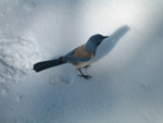
Cool stuff. Dunno about that brush though. I've seen enough brush for a lifetime. I guess you met Kathy on a summit from the looks of the photo?
So, dunno if this is too nit-picky, but I enjoy your Google Earth maps showing the route. Any chance you could lose the dark blue labels?. I can't read 'em; not enough contrast. The green ones are fine.
So, dunno if this is too nit-picky, but I enjoy your Google Earth maps showing the route. Any chance you could lose the dark blue labels?. I can't read 'em; not enough contrast.
-
calicokid
- Posts: 90
- Joined: Wed Feb 27, 2008 1:07 pm
Nice hike. I lived right by the foothill of monrovia but never did this hike yet! This will be my goal of this year, again! Last time my son and I turned around because of the bush.
Thanks for the report
Thanks for the report
-
calicokid
- Posts: 90
- Joined: Wed Feb 27, 2008 1:07 pm
Nice hike. I lived right by the foothill of monrovia but never did this hike yet! This will be my goal of this year, again! Last time my son and I turned around because of the bush.
Thanks for the report
Thanks for the report
-
KathyW
- Posts: 212
- Joined: Thu Sep 27, 2007 9:00 pm
Joe: It was a pleasure to meet you too. I thought I'd see your group again on the way down, but it looks like you took the trail part of the way down and didn't stay on the road.
Kathy
Kathy
-
Ze Hiker

- Posts: 1432
- Joined: Mon Jul 28, 2008 7:14 pm
Heh, the first video was just a special case, and can be avoided. The 2nd video is more typical of what you'd deal with.EnFuego wrote:WOW! That looks like quite the hike. The bush whacking in the first video doesn't look too appealing to me. Were there many sections like that?
In any case, I commend you and your group for completing the long hike.
Do you know if Adjala was named after the town in Ontario, Canada? Or named after the wife of Chief Tecumseh?
I'm not sure about the name, Sascha (dog's owner) didn't pick the name b/c of meaning, more of he liked it. I told him it's similar to a hebrew name (Ayala) and he wanted to know what it meant (baby goat!).
Cross paths with Kathy a few times. She was leaving to start the hike as we were waiting for everyone to show up. I asked where she was planning on going (not knowing who she was) b/c who goes hikes up that ridge alone? Then saw her on the way up and then also at the peak.Hikin_Jim wrote:Cool stuff. Dunno about that brush though. I've seen enough brush for a lifetime. I guess you met Kathy on a summit from the looks of the photo?
So, dunno if this is too nit-picky, but I enjoy your Google Earth maps showing the route. Any chance you could lose the dark blue labels?. I can't read 'em; not enough contrast.
Yeah I can take those blue ones off, there useless anyways.
Yes having the right clothing and mental preparation for dealing with brush makes a huge difference! Last time I did not expect it and it was definitely more annoying. This time liked it.calicokid wrote:Nice hike. I lived right by the foothill of monrovia but never did this hike yet! This will be my goal of this year, again! Last time my son and I turned around because of the bush.
Thanks for the report
Nice meeting you too. Well you ran off (literally) so I figured you ran all the way down, did you walk at some point?KathyW wrote:Joe: It was a pleasure to meet you too. I thought I'd see your group again on the way down, but it looks like you took the trail part of the way down and didn't stay on the road.
Kathy
-
KathyW
- Posts: 212
- Joined: Thu Sep 27, 2007 9:00 pm
I jogged along slowly for a couple of miles, but then I reverted to walking. I got back to my truck at around 5 pm, so at least it was still daylight.
-
Leslie L
- Posts: 46
- Joined: Wed Oct 03, 2007 5:39 pm
Ze/Kathy,
How do you rate the route finding on this loop? Do you have tips for any tricky sections? Thanks.
How do you rate the route finding on this loop? Do you have tips for any tricky sections? Thanks.
-
KathyW
- Posts: 212
- Joined: Thu Sep 27, 2007 9:00 pm
Leslie: Overall, route finding wasn't too difficult. You'll need to watch for where you leave the road to pick up the ridge to Clamshell. Also, you need to stay on the loose/steep ridge where the Bill Cull Trail intersects the ridge, so watch for that intersection and don't head down the Bill Cull Trail. Once you drop down from Clamshell heading toward Rankin, you will pick up the road for a section. When you're on the road. you'll need to watch for where you leave the road to pick up the ridge to Rankin and Monrovia. The route down along the road was long but obvious.
Kathy
Kathy
-
Ze Hiker
- Posts: 1432
- Joined: Mon Jul 28, 2008 7:14 pm
I was going to mention the same thing Kathy mentioned.
When you are coming up the first ridge, you'll be heading NE. At some point you'll hit the bottom of bigger north/south ridge that you need to get up.
The best and easiest option is the follow the blue path. As Kathy said, if you continue on the trail (red) you'll take the bill cull trail and miss the ridge entirely. If you take the first little ridge (yellow) and not the second (blue), it's harder to get up. The first video in my TR is Ofir trying to get up the yellow! Everyone else in the group went up the blue way.
-
Leslie L
- Posts: 46
- Joined: Wed Oct 03, 2007 5:39 pm
Perfect, that is just the kind of information I was looking for. Joseph, I cannot see your attachment, would you mind posting it again or send it to me via p.m.?
Thanks again.
Thanks again.
-
Hikin_Jim
- Posts: 4688
- Joined: Thu Sep 27, 2007 9:04 pm
If you're using Internet Explorer, right click on the image, select "Properties," and then cut and paste the address (i.e. URL) into a browser window.
-
HikeUp

- Posts: 4098
- Joined: Thu Sep 27, 2007 9:21 pm
A year ago I ascended via the Bill Cull "trail". It was a serious bushwhack in several sections and was almost entirely washed out in the section nearest to where it joins the blue line in Joe's picture. Made for a rather shaky traverse - not recommended until the trail is rebuilt (which I really wish they would do because it would be a very nice front country trail with some nice views, some shade, not too steep, etc.).Zé wrote:As Kathy said, if you continue on the trail (red) you'll take the bill cull trail and miss the ridge entirely.
-
Ze Hiker
- Posts: 1432
- Joined: Mon Jul 28, 2008 7:14 pm
It's odd really how this front range chunk doesn't have many trails (no 'reasonable' ascent to Monrovia IMO) while the peaks to the west have plenty.
Then I read this again about 'trails that once were'
"Monrovia Peak Trail: This was once a favorite of Big Santa Anita Canyon hikers, going from Fern Lodge up the East Fork to Clamshell Ridge and on to the summit. Today, the middle stretch from the East Fork up to the Clamshell fire road is completely overgrown and impassable."
"Deer Park-Monrovia Trail: Ben Overturff built this trail from Deer Park Lodge up the long southeast ridge of Monrovia Peak to the summit in 1914-1915. It fell into disrepair when Deer Park was abandoned after the 1938 flood."
Intrigued to check these out some time. If they are referring to the upper Clamshell fire road, the first one sounds interested. I noticed the southeast ridge and thought it had potential, would love to see if that has potential.
-
Hikin_Jim
- Posts: 4688
- Joined: Thu Sep 27, 2007 9:04 pm
I've been on some of those 'trails that once were'. Some of them, particularly in chapparal areas have vanished without a trace. I remember trying to follow the old Zion trail before it was restored. Holy bushwhack, Batman! The Tom Sloane Trail was better but still tough.
Good luck on those trails. Hope you find 'em!
Good luck on those trails. Hope you find 'em!
-
HikeUp
- Posts: 4098
- Joined: Thu Sep 27, 2007 9:21 pm
As I had mentioned in the thread I linked to above, I had seen a TR from someone who hiked from Chantry to Monrovia. I found the link!Hikin_Jim wrote:I've been on some of those 'trails that once were'. Some of them, particularly in chapparal areas have vanished without a trace. I remember trying to follow the old Zion trail before it was restored. Holy bushwhack, Batman! The Tom Sloane Trail was better but still tough.
Good luck on those trails. Hope you find 'em!
Also Brennen climbed a ridge from below Hermit falls up to upper clamshell road - sounds like no fun.
-
Ze Hiker
- Posts: 1432
- Joined: Mon Jul 28, 2008 7:14 pm
ha! it was bad in the 40 yr old trip report, so there's probably nothing there now.
I just took a look at the Monrovia Peak route descriptions, and they've just deleted the Bill Cull route!
HikeUp, I bet you wish they updated that a year ago!
I just took a look at the Monrovia Peak route descriptions, and they've just deleted the Bill Cull route!
HikeUp, I bet you wish they updated that a year ago!
-
HikeUp
- Posts: 4098
- Joined: Thu Sep 27, 2007 9:21 pm
Zé wrote:I just took a look at the Monrovia Peak route descriptions, and they've just deleted the Bill Cull route!
HikeUp, I bet you wish they updated that a year ago!
Bastards.
-
Hikin_Jim
- Posts: 4688
- Joined: Thu Sep 27, 2007 9:04 pm
From the above link:
If I'm not mistaken, this 1966 hike was taken before the road and flood control dams were put into place in the late 60's. Would have been neat to have seen the canyon pre-flood control dams.From the ranger station we dropped down to the floor of Santa Anita Canyon...