
Smith Mtn via Mt Islip
-
bechtt
- Posts: 17
- Joined: Sat Oct 06, 2007 10:16 am
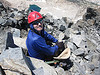
Woke up Sunday expecting to hike in bad weather but found the sky clear. Decided to climb Smith Mtn from Islip Saddle instead of the lower closed gate at SR39 (at the West Fork junction). Bob L. and Coco the Dog joined me on this trip. After climbing Mt Islip via the NW Ridge, we descended the abandoned Wawona trail that follows Islip's south ridge all of the way to Crystal Lake. At one time, this was an exceptional trail and in many parts still is. However, numerous fallen trees blocked the trail in places (worse as we got lower) requiring (mostly easy) detours. Near the end of the ridge, the trail turns towards Crystal Lake while we kept going south towards SR39. Bob chose to fight the brush down the ridge while Coco and I chose one of the gullies to the road (some brush as well). After hitting SR39 (and meeting back up with Bob), we followed the fire break over Peak 5495, down to the saddle, and up Smith Mtn. We returned over the same fire break route but then walked the upper part of SR39 back to Islip Saddle. Cold day but no snow from Saturday's storm. I'm sure today's storm made up for it.
-
Hikin_Jim

- Posts: 4688
- Joined: Thu Sep 27, 2007 9:04 pm
Wow. Sounds like a pretty tough hike.
That Wawona Trail, that's an interesting name. I've heard that one referred to as the Big Cienaga Trail, not sure if there's an "official" name. When combined with the Windy Gap Trail, the Wawona/Big Cienaga trail makes a really nice intermediate loop out of the Crystal Lake area. Shame that it's been let go, but then again, the whole Crystal Lake area has been closed for some years.
That Wawona Trail, that's an interesting name. I've heard that one referred to as the Big Cienaga Trail, not sure if there's an "official" name. When combined with the Windy Gap Trail, the Wawona/Big Cienaga trail makes a really nice intermediate loop out of the Crystal Lake area. Shame that it's been let go, but then again, the whole Crystal Lake area has been closed for some years.
-
AW~

- Posts: 2109
- Joined: Mon Oct 01, 2007 12:00 pm
Underrated summits and trip IMO.....eventually the 3 closed areas will open up and I think the views look really good...those weather hoaxsters...way off again.
-
Taco

- Snownado survivor
- Posts: 6191
- Joined: Thu Sep 27, 2007 4:35 pm
Nice area with awesome views. That's a nice way to walk back, too. 8)
-
bechtt
- Posts: 17
- Joined: Sat Oct 06, 2007 10:16 am
Not too tough of a hike compared to the previous week with Bob Burd. 
The Wawona name came off the Tom Harrison map that I have. However, San Gabriel Mountains Trailbuilders calls the trail we were on the Islip Ridge Trail and the trail from Crystal Lake that accesses the ridge as the Wawona cutover (although there's no other way to access it from below except by bushwacking like we did). The Big Cienaga trail links the lower end of the Windy Gap trail to about halfway up the Islip Ridge. I bow to the S.G.M. Trailbuilders naming convention since they built the trails.
Hey Ryan. The views were well worth it and the hike back up SR39 wasn't too bad either.
-
Augie

- Posts: 345
- Joined: Fri Sep 28, 2007 2:17 pm
All sounds way cool Tom. And imagine-at least during these holiday months-Coco gets out hiking a lot more than I do.
Merry Xmas everybody.
Merry Xmas everybody.
-
Hikin_Jim
- Posts: 4688
- Joined: Thu Sep 27, 2007 9:04 pm
O.K, gotcha. That helps me to get things lined out a little better. Thanks.bechtt wrote:The Wawona name came off the Tom Harrison map that I have. However, San Gabriel Mountains Trailbuilders calls the trail we were on the Islip Ridge Trail and the trail from Crystal Lake that accesses the ridge as the Wawona cutover (although there's no other way to access it from below except by bushwacking like we did). The Big Cienaga trail links the lower end of the Windy Gap trail to about halfway up the Islip Ridge. I bow to the S.G.M. Trailbuilders naming convention since they built the trails.
High time they opened up Crystal Lake so I don't have to try to remember trail names based on hikes from years ago.
-
bechtt
- Posts: 17
- Joined: Sat Oct 06, 2007 10:16 am
Agree Jim, it's a real neat area. On the other hand, there would be a heck of a lot more people on the trails.
Merry X-mas to you too, Augie. Coco is starting to show her age -- she only got to the top of Iron a couple of minutes before me this last time.
As for the Sierra Challenge, I have to get in a lot better shape since Bob is aiming for the interior peaks on about half of the hikes. Marion, in particular, requires 8 miles and 6000' just to get to the pass with another 9 miles and 3500' to the peak. And that's just half way.
Are you going to join us this year, Ryan? There's a couple of good technical peaks on the list -- one that will require a 1000' couloir climb. Plenty of people going from LA so you should be able to find a ride.
-
Taco
- Snownado survivor
- Posts: 6191
- Joined: Thu Sep 27, 2007 4:35 pm
Sounds fun. I'd give it a shot.
Nice list for next year, haven't heard of most of them!
Nice list for next year, haven't heard of most of them!
-
Zach

- Posts: 522
- Joined: Sun Jan 04, 2009 4:25 pm
I was always curious about Crystal Lake. Since I've been going to the Angeles Forest the lake has been closed. Can the lake still be accessed via trails? If so, is it legal to camp out there or will you get booted by the rangers? If it is open, what's the condition of the lake, any fish? 