
The Station Fire Thread
-
Taco

- Snownado survivor
- Posts: 6218
- Joined: Thu Sep 27, 2007 4:35 pm
Regarding R39 and GMR/GRR, I read that they're only open to residents with ID. Reckon this is still the case despite today being OCT 1, yes?
-
AW~

- Posts: 2125
- Joined: Mon Oct 01, 2007 12:00 pm
I would love to be proven wrong on it.....but it does state the closure area goes along these boundariesHikeUp wrote:Same question with all the boundaries that follow trails or roads.
Sure go to Hoeges camp, just take the LSA trail to Winter Creek and descend to Hoeges. Or trying to go to Muir Peak?
-
HikeUp

- Posts: 4098
- Joined: Thu Sep 27, 2007 9:21 pm
LOL @ Muir. I'll risk it...go ahead and tell me!
-
Ze Hiker

- Posts: 1432
- Joined: Mon Jul 28, 2008 7:14 pm
hey don't you remember my brushy exploration SW ridge of Muir? I already found a way. There might be a better way.
-
Ze Hiker
- Posts: 1432
- Joined: Mon Jul 28, 2008 7:14 pm
so it lists all the boundaries of the closed region. are the trails / roads ON the boundary closed? in some cases it mentions the 'west' or 'east' side of the road as the boundary, but in many cases it doesn't mention either.
-
AlanK

- Posts: 1069
- Joined: Thu Sep 27, 2007 9:28 pm
From the Los Angeles Times
U.S. Forest Service launches inquiry into Station fire response
The agency scaled back its attack the night before the blaze, the biggest in Los Angeles County history, began to burn out of control.
By Paul Pringle
October 1, 2009
Quantcast
The U.S. Forest Service has launched an internal inquiry into the agency's attack on the deadly Station fire, an operation that was scaled back the night before the blaze began to burn out of control.
"With the significant loss of life, and impacts to the local community, we must determine the effectiveness of our efforts," Forest Service Chief Thomas Tidwell said in a written statement Wednesday. Tidwell said he would ask other agencies to participate in the review.
But the Forest Service has declined to release detailed information about its response to the suspected arson fire, citing in part an ongoing homicide investigation by the Los Angeles County Sheriff's Department into the deaths of two firefighters whose truck fell off a mountain road. Sheriff's spokesman Steve Whitmore said the department sent a letter Wednesday to fire officials asking that the material be withheld until detectives review it.
Neither Forest Service officials nor Whitmore would explain how the release of information on the deployment of firefighters and equipment might jeopardize the investigation. The firefighters were killed on the blaze's fifth day.
The Times reported this week that the Forest Service considered the fire nearly contained at the end of the first day, and thus prepared to go into mop-up mode the next morning with fewer ground crews and water-dropping helicopters, according to documents and interviews. After the story appeared, fire victims demanded an investigation.
The blaze, which broke out Aug. 26, destroyed about 90 homes and other buildings and blackened more than 160,000 acres of the Angeles National Forest. It is the largest fire in the county's recorded history.
Big Tujunga Canyon residents, many of whom lost homes to the fire, said they welcomed the Forest Service inquiry, but were skeptical that it would be as rigorous as an independent probe.
"Will we get the truth? I don't know," said Cindy Marie Pain, whose Stonyvale Road house burned down. She said she believed the Forest Service was withholding information on its tactics because "they look bad enough already."
Residents have accused the Los Angeles County Fire Department of not doing enough to keep the flames from the canyon community after the blaze spread from its starting point above La Cañada Flintridge. County officials have said the department did all it could without risking the lives of firefighters.
Meanwhile, Rep. Adam Schiff (D-Glendale), whose district borders the Angeles National Forest, said the Forest Service failed to address concerns that he and five other local members of Congress raised more than two years ago about the agency's firefighting capabilities.
In an August 2007 letter, the lawmakers cited reports of a "severe shortage of qualified supervisors" in the forest and complaints that many firefighters had quit because of low pay and management that "has not been responsive."
"We'll look at what the Forest Service investigation reveals and we'll see if a broader investigation needs to be done," Schiff said Wednesday. "It seems to me that this is a situation where you would want maximum transparency."
The Times reported that in the evening of the fire's first day, the Forest Service estimated that the blaze would be controlled by the following afternoon, with no loss of structures and minimal harm to the natural treasures of the San Gabriel Mountains. Overnight, as the 15-acre fire grew, the Forest Service realized its mistake and began to summon more equipment and crews.
On that fateful second day, the county department lent the Forest Service a heli-tanker but denied its request for another smaller chopper, according to documents and interviews.
Chief Deputy John Tripp, the department's No. 2 official, said he made that decision because he did not believe the fire was endangering neighborhoods, and because the county must keep some helicopters for other emergencies.
paul.pringle@latimes.com
-
Elwood

- Posts: 627
- Joined: Fri Aug 15, 2008 5:23 pm
Let's call this a derivative artwork. Extracted the blue closure boundary from the horrible pdf. Scaled it and slightly rotated it to register with the gridlines of the forest service visitor's map. Composited it with higher-resolution image of same. Created JPEG. This is slightly more legible than the official document but not to be construed as authoritative by any means. I'm also confused as to why the Kentucky Shooting area registers so badly. The layered PSD file is sitting here if anyone wants to play with it.
"www.electricskates.com/Pix/Other/CMAP.psd"
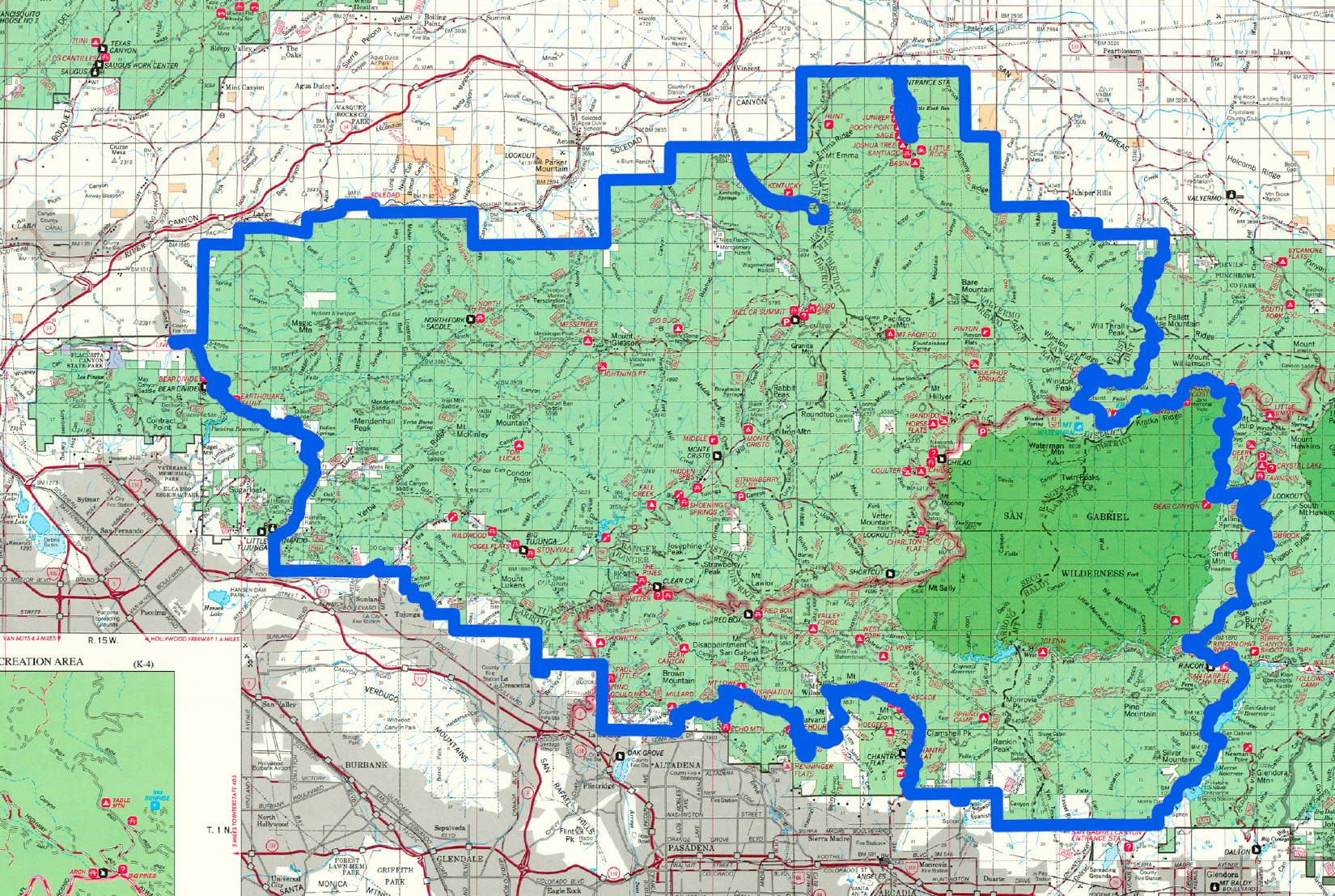
"www.electricskates.com/Pix/Other/CMAP.psd"
-
HikeUp
- Posts: 4098
- Joined: Thu Sep 27, 2007 9:21 pm
Cool. Where'd ya get the hi-res version of the ANF map?
-
AW~
- Posts: 2125
- Joined: Mon Oct 01, 2007 12:00 pm
Hows this?HikeUp wrote:Same question with all the boundaries that follow trails or roads.
http://www.socaltrailriders.org/forum/t ... osure.htmlJoeTruth writes:As of Wednesday September 30th, Chantry, the Mt. Wilson toll road & Mt Lowe toll road are open (but only up to around the Idlehour trail). Chantry part of Angeles National Forest is open and you will not be ticketed. ...... The closure borders are very confusing so it's going to be interesting how they're going to mark it clearly or provide maps of closures. For instance, all of Winter Creek, Zion and The Gab is open but the Newcomb Pass Trail leading up to The Rim trail and Rincon Fire road is closed and off limits. The Merrill's up to Inspiration Point are open again but not beyond. Again, very confusing but at least we have that much to access"
-
HikeUp
- Posts: 4098
- Joined: Thu Sep 27, 2007 9:21 pm
My question is unanswered, at least definitively. Joe Truth (lol@name) seems to be erring on the safe side, where as my interpretation is that the trails and roads that form the boundary are open. But as usual, who the heck knows for sure. I'd bet if you were on the Mt. Wilson Toll Road above Idlehour Trail Head, and you came across 2 different rangers, one would write you a ticket or warning, and the other would say hello and warn you not to stray from the road on the closure side.
Unless I hear more definitive news regarding this, I'm planning on hiking the Toll Road up to Mt. Wilson next weekend.
Unless I hear more definitive news regarding this, I'm planning on hiking the Toll Road up to Mt. Wilson next weekend.
-
HikeUp
- Posts: 4098
- Joined: Thu Sep 27, 2007 9:21 pm
Ze...you're gonna get banned for comments like that! 

-
Taco
- Snownado survivor
- Posts: 6218
- Joined: Thu Sep 27, 2007 4:35 pm
He'd probably go cry in a corner in his house.
He's probably going to read this, and go cry in a corner of his house, but not before he complains on whatever forum hasn't banned him yet (summitpost).
He's probably going to read this, and go cry in a corner of his house, but not before he complains on whatever forum hasn't banned him yet (summitpost).
-
AW~
- Posts: 2125
- Joined: Mon Oct 01, 2007 12:00 pm
You mean the entire closed section becomes a Crystal Lake? Or a Snow Creek? 
Its easy to bash the Forest Service here, but what would be a realistic plan?
Could start talking about a permit system, but you aint getting my vote for that even if it means anarchy as the other option.
Its easy to bash the Forest Service here, but what would be a realistic plan?
Could start talking about a permit system, but you aint getting my vote for that even if it means anarchy as the other option.
-
HikeUp
- Posts: 4098
- Joined: Thu Sep 27, 2007 9:21 pm
I can be very dense for most of my awake hours but I'm not sure wtf you're talking about AW  - what am I missing?
I want the Forest Service to tell me in clear language whether I can walk on the trails and roads that form the boundary of the closure area. Seems like one should be able to do so, or at least walk 1 inch to the non-closure side of the trail /road. Anyway, what's tiresome about almost everything the Forest does is that it is almost always ambiguous at best. Very tiresome.
I want the Forest Service to tell me in clear language whether I can walk on the trails and roads that form the boundary of the closure area. Seems like one should be able to do so, or at least walk 1 inch to the non-closure side of the trail /road. Anyway, what's tiresome about almost everything the Forest does is that it is almost always ambiguous at best. Very tiresome.
-
MtnMan
- Posts: 143
- Joined: Fri May 08, 2009 2:22 am
move to the beach then.HikeUp wrote:I can be very dense for most of my awake hours but I'm not sure wtf you're talking about AW
I want the Forest Service to tell me in clear language whether I can walk on the trails and roads that form the boundary of the closure area. Seems like one should be able to do so, or at least walk 1 inch to the non-closure side of the trail /road. Anyway, what's tiresome about almost everything the Forest does is that it is almost always ambiguous at best. Very tiresome.
otherwise use your noggin, do some fingerwork and call someone instead of whining.
I agree things can often be ambiguous with the USFS, and the people within the agency suck at communicating sometimes, but in their defense, things like this are not as simple as closing a ride at Disneyland.
Gerry R. is your best bet for the LA Dist.. 818-899-1900 x228 He's usually in his office office Sunday -Thurs.
I'm not sure who would be the best contact on the San Gabriel RRD... maybe Lois P....?
SCMRRD for Wrightwood area, call Todd Big Pines at 760-249=3504 on Friday- Sun.
-
Ze Hiker
- Posts: 1432
- Joined: Mon Jul 28, 2008 7:14 pm
i'm sorry but that is utter bullshit.MtnMan wrote: move to the beach then.
otherwise use your noggin, do some fingerwork and call someone instead of whining.
I agree things can often be ambiguous with the USFS, and the people within the agency suck at communicating sometimes, but in their defense, things like this are not as simple as closing a ride at Disneyland.
1) 7 times out of 10, I call them about something and they screw up. they respond with a FALSE statement. in these situations they are either lying, think they know but they don't, or know they don't know but pretend they do
2) 2 times out of 10 they actually say "i don't know"
3) 1 time out of 10 they actually are right (i.e. I called Mt Baldy visitor center and they confirmed Baldy Ski Lift was open but couldn't hike there)
so, no, "fingerwork" is practically useless. it's a damn shame too.
things like this are not as simple as closing a ride at Disneyland
i don't think anyone is knocking them for taking time to decide what the closed boundaries should be. once they make a decision, however, they are simply not clear. not straightforward.
Visualization of a closed area is important. They have just about the crappiest map resolution I've seen uploaded for people to view what is "closed". Give me a break. Upload a goddamn better resolution map. It's not that hard. Hell Elwood did a better job in his spare time. What a fucking joke.
-
MtnMan
- Posts: 143
- Joined: Fri May 08, 2009 2:22 am
I agree about the piss-poor map, and the lame effort sometimes put forth on alot of things the USFS does. Like the pathetic thing called a website and information exhanging. It could (and should!) be so much better.
I also agree that your average person that answers the phone at some USFS offices is often clueless. However, that's why I gave some specific names of people that usually know what's going on, and actually get out there and do some of the same things many of us here love to do.
There are actually a few good, knowledgeable people that work for the Angeles. You just gotta know who they are, get in touch with them, and try not to rely on the stuff that is meant for the masses (which again, should still be better than it is).
-
HikeUp
- Posts: 4098
- Joined: Thu Sep 27, 2007 9:21 pm
I agree with everything you just said.MtnMan wrote:I agree about the piss-poor map, and the lame effort sometimes put forth on alot of things the USFS does. Like the pathetic thing called a website and information exhanging. It could (and should!) be so much better.
I also agree that your average person that answers the phone at some USFS offices is often clueless. However, that's why I gave some specific names of people that usually know what's going on, and actually get out there and do some of the same things many of us here love to do.
There are actually a few good, knowledgeable people that work for the Angeles. You just gotta know who they are, get in touch with them, and try not to rely on the stuff that is meant for the masses (which again, should still be better than it is).
There are reasons things aren't communicated properly, clearly, or whatever. Like underfunding, politics, under-staffing, blah blah blah. But that doesn't eliminate the fact that things aren't communicated properly, clearly or whatever. I'm just pointing out that fact in hopes that someone can offer clarity. You have done so and thanks. I'll give those people a call (and without those names, it would be a crap shoot). Sorry it sounds like whining, but it isn't.
See ya on the boundaries! Or in jail.
-
Layne Cantrell

- Posts: 127
- Joined: Tue Sep 01, 2009 5:20 pm
Couldn't get an answer about boundaries/open highways/trails from Mike McIntyre. Asked him about Buckhorn specifically, but he said it won't be accessible from the highway until November - right when they close it.
I asked about getting there from Wrightwood which I'm not sure he was clear on. In any case I'm not sure how they'd open the highway all the way up there and also maintain the closures.
Very confusing stuff indeed.
I asked about getting there from Wrightwood which I'm not sure he was clear on. In any case I'm not sure how they'd open the highway all the way up there and also maintain the closures.
Very confusing stuff indeed.
-
cougarmagic

- Posts: 1414
- Joined: Wed May 07, 2008 5:21 pm
I'm going up to Vincent Gap, and hopefully farther, tomorrow, so I'll let you all know what I find out. If there is anyone to ask, I specifically am going to find out about being able to walk or bike ACH beyond Islip Saddle.
-
Layne Cantrell
- Posts: 127
- Joined: Tue Sep 01, 2009 5:20 pm
You're my hero! I crave information!!! Must... have... info...cougarmagic wrote:I'm going up to Vincent Gap, and hopefully farther, tomorrow, so I'll let you all know what I find out. If there is anyone to ask, I specifically am going to find out about being able to walk or bike ACH beyond Islip Saddle.
-
MtnMan
- Posts: 143
- Joined: Fri May 08, 2009 2:22 am
Highway 2 from the Wrightwood side is now re-opened to vehicles to Vincent Gap. That's where the closed gate is.
Legally, you can walk/bike past the gate at Vincent Gap at this time, but the area is behind a gate, and not patrolled, so you're on your own, and you may encounter fire/construction traffic/horny bighorn sheep (and if something happens, don't sue anyone. )
)
Now, if Cal-Trans or CHP decides they want to kick you out, that's their right since it's a state hwy. However, USFS does not have a closure to public entry behind the Vincent Gap gate to Islip Saddle gate.
Next: The official Fire Closure area begins AT Islip Saddle, so you're not supposed to go any further west than that on road or trail. So no, Buckhorn is not accessible at all right now even though part of the closure boundary straddles Hwy 2. There was slopover from the fire near Cloudburst Summit.
Layne, what other info do you want about "boundaries/open highways/trails"? I have a hard time believing Mike M couldn't answer any of your questions. He's a pretty sharp guy.
Legally, you can walk/bike past the gate at Vincent Gap at this time, but the area is behind a gate, and not patrolled, so you're on your own, and you may encounter fire/construction traffic/horny bighorn sheep (and if something happens, don't sue anyone.
Now, if Cal-Trans or CHP decides they want to kick you out, that's their right since it's a state hwy. However, USFS does not have a closure to public entry behind the Vincent Gap gate to Islip Saddle gate.
Next: The official Fire Closure area begins AT Islip Saddle, so you're not supposed to go any further west than that on road or trail. So no, Buckhorn is not accessible at all right now even though part of the closure boundary straddles Hwy 2. There was slopover from the fire near Cloudburst Summit.
Layne, what other info do you want about "boundaries/open highways/trails"? I have a hard time believing Mike M couldn't answer any of your questions. He's a pretty sharp guy.
-
Layne Cantrell
- Posts: 127
- Joined: Tue Sep 01, 2009 5:20 pm
This was exactly what I was wondering about. Its confusing since the highway acts as part of the boundary. My question is whether or not the highway itself is off limits since the area north of it is open all the way to Cloudburst.MtnMan wrote: Next: The official Fire Closure area begins AT Islip Saddle, so you're not supposed to go any further west than that on road or trail. So no, Buckhorn is not accessible at all right now even though part of the closure boundary straddles Hwy 2. There was slopover from the fire near Cloudburst Summit.
I crave any info about the Islip/Buckhorn area. Mike M is the MAN - he fed me as much info via email as he could during this whole ordeal. I think I just didn't phrase my question right. His answer had to do with how I'd reach/not reach Buckhorn from Glendale instead of Wrightwood which is what I meant to ask him about.Layne, what other info do you want about "boundaries/open highways/trails"? I have a hard time believing Mike M couldn't answer any of your questions. He's a pretty sharp guy.
-
simonov

- Posts: 1110
- Joined: Tue Nov 27, 2007 5:44 pm
- Location: Reno, NV
Zé, the problems you are experiencing are due to the Forest Service not having local specialists in graphics and communications who can ensure that policies are clearly promulgated throughout the agency and to the public. Everything is being done ad hoc.
The way it works is, the District Supervisor determines they need a map of the closure area, and canvasses the office to see if there's anyone who can use Photoshop. Someone raises her hand and she gets the job.
The way it works is, the District Supervisor determines they need a map of the closure area, and canvasses the office to see if there's anyone who can use Photoshop. Someone raises her hand and she gets the job.
Nunc est bibendum
-
AW~
- Posts: 2125
- Joined: Mon Oct 01, 2007 12:00 pm
I was getting ahead of the discussion perhaps...heres a snipet from that forum...HikeUp wrote:I can be very dense for most of my awake hours but I'm not sure wtf you're talking about AW
I want the Forest Service to tell me in clear language whether I can walk on the trails and roads that form the boundary of the closure area. Seems like one should be able to do so, or at least walk 1 inch to the non-closure side of the trail /road. Anyway, what's tiresome about almost everything the Forest does is that it is almost always ambiguous at best. Very tiresome.
"But there are closed trails and roads that intersect with the open areas. If we see traffic on the closed area trails and roads and the people are accessing from the open trails and routes, then we will take a tough look at closing trails and roads that are now open."
Add this to the AFH&ACH opening up sometime this year.
Think that the boundaries can possibly be explained and complied with? Most of the public does not go to the website or call a certain mr.X at the office. Thus the direction we are headed is chronic closures...the leading example being Crystal Lake...unless MtnMan or anyone can explain why that area is closed besides the official law of the land.
The Station fire was a game changer and thus far, all the planning is like nothing ever happened...its just burnt...its just not realistic.
So after the public is walking on the closed areas..now what? I suppose in Crystal Lake its closed but look the other way is the policy...thus people who want to comply get left out in the cold....and then when you call them like I did back in 2006 when it was 100% that the Crystal Lake was going to open, you get informed the opening date was changed to a date to be determined...dont even bother calling now...and thats the path we are headed toward on this Station fire area.
In addition, we have these crazy plans like the AFH is going to be commuter only and 'civilized' as if anyone really believes that will happen...or as mentioned , the East Fork SG river can hold the entire Hwy39 crowd...once 39 opens
Thats the best case scenario IMO. I think even more realistic is landslides occur and make the place closed forever due to no highway access.
In the worst case scenario, the fire setters move east now and the potential for the east side being scorched is now is much greater.
Thats why I mentioned a permit system that limits access(sometimes as low as 12 people per day) but still provides it....go to the office, sign away the forest liability,etc...
My thinking is we go out there and preserve the roads...massive volunteer effort...wouldnt care if the cliffside had to be covered in cement...whatever we can do to stop landslides. For the open/closed line, right now its OK, but also volunteers to get more trail open like the MtWilson toll road. And open the West Fork SG river for sure.
-
cougarmagic
- Posts: 1414
- Joined: Wed May 07, 2008 5:21 pm
Thanks for the good information, MtnMan. I'm so jaded about calling rangers, I just go look for myself at this point. But, you were absolutely right - big closed gate at Vincent Gap. There were few cars in the Baden Powell parking lot, so I guess not many people know it's open yet.
Layne - couldn't get near Buckhorn, but I hiked up from South Fork almost to Islip saddle, and it looks green, beautiful, with dark blue skies, fresh air and lots of life. I am sure Buckhorn is the same!! I expected to see ash on the leaves, but there was none. It was really good to see.
Layne - couldn't get near Buckhorn, but I hiked up from South Fork almost to Islip saddle, and it looks green, beautiful, with dark blue skies, fresh air and lots of life. I am sure Buckhorn is the same!! I expected to see ash on the leaves, but there was none. It was really good to see.
-
edenooch

- Posts: 504
- Joined: Fri Jul 03, 2009 7:42 pm
And some good got on my case once about the FS being incompetent!Zé wrote:i'm sorry but that is utter bullshit.MtnMan wrote: move to the beach then.
otherwise use your noggin, do some fingerwork and call someone instead of whining.
I agree things can often be ambiguous with the USFS, and the people within the agency suck at communicating sometimes, but in their defense, things like this are not as simple as closing a ride at Disneyland.
1) 7 times out of 10, I call them about something and they screw up. they respond with a FALSE statement. in these situations they are either lying, think they know but they don't, or know they don't know but pretend they do
2) 2 times out of 10 they actually say "i don't know"
3) 1 time out of 10 they actually are right (i.e. I called Mt Baldy visitor center and they confirmed Baldy Ski Lift was open but couldn't hike there)
so, no, "fingerwork" is practically useless. it's a damn shame too..
-
Layne Cantrell
- Posts: 127
- Joined: Tue Sep 01, 2009 5:20 pm
Again, you're my hero! I actually went up to Wrightwood to visit my brother who rented a cabin there - about three hours after I got there, my triumphant return to the Angeles, we were evacuated. Very traumatic.cougarmagic wrote: Layne - couldn't get near Buckhorn, but I hiked up from South Fork almost to Islip saddle, and it looks green, beautiful, with dark blue skies, fresh air and lots of life. I am sure Buckhorn is the same!! I expected to see ash on the leaves, but there was none. It was really good to see.