The Station Fire Thread

Rescues, fires, weather, roads, trails, water, etc.
User avatar
mattmaxon
Posts: 1137
Joined: Mon Mar 24, 2008 12:48 pm

Post by mattmaxon »

cougarmagic wrote:Holy Hell.

One news report this morning said there is now a forest-wide closure. Haven't been able to confirm that, though.
There is a closure order for San Gabriel Canyon going into effect today

http://www.inciweb.org/incident/article/9302/

Like I said the media are morons, shut off the sound, hopefully they'll show something useful
User avatar
edenooch
Posts: 504
Joined: Fri Jul 03, 2009 7:42 pm

Post by edenooch »

damn!!
User avatar
Hikin_Jim
Posts: 4686
Joined: Thu Sep 27, 2007 9:04 pm

Post by Hikin_Jim »

I see that it says that the San Gab Cnyn area is closed, but I don't see anything about the forest in general. Alternate link?
User avatar
HikeUp
Posts: 3902
Joined: Thu Sep 27, 2007 9:21 pm

Post by HikeUp »

A walk out on Brown Mtn. Road would be interesting right about now!
User avatar
AW~
Posts: 2059
Joined: Mon Oct 01, 2007 12:00 pm

Post by AW~ »

Hikin_Jim wrote:I see that it says that the San Gab Cnyn area is closed, but I don't see anything about the forest in general. Alternate link?
ANF website :D , I dont know but think its a good idea until they can get some of the recent stuff out. One more fire around here and I might not be able to breathe! muchless see anything.
User avatar
Hikin_Jim
Posts: 4686
Joined: Thu Sep 27, 2007 9:04 pm

Post by Hikin_Jim »

Fire Map from LA Times
It says no structures under immediate threat (as of about 6 this morning). My mom lives in Briggs Terrace. :shock:


The live video feed from Fox is mostly covering the Station Fire right now.


Today's statewide map:
Image
User avatar
cougarmagic
Posts: 1409
Joined: Wed May 07, 2008 5:21 pm

Post by cougarmagic »

No of course not, those guys were being 'careful' obviously.
User avatar
Mike P
Posts: 1005
Joined: Tue Oct 02, 2007 10:48 pm

Post by Mike P »

A-Mazing:
Image
User avatar
Hikin_Jim
Posts: 4686
Joined: Thu Sep 27, 2007 9:04 pm

Post by Hikin_Jim »

TacoDelRio wrote:I've seen him rappel with TWO chainsaws... into a pool full of molten-steel sharks.
Ha! Those chainsaws were electric, so those sharks are history. Of course what does that say about Matt? ALIEN! :shock:
User avatar
cougarmagic
Posts: 1409
Joined: Wed May 07, 2008 5:21 pm

Post by cougarmagic »

Los Angeles, CA:

Image

Mordor, Middle Earth:

Image
User avatar
edenooch
Posts: 504
Joined: Fri Jul 03, 2009 7:42 pm

Post by edenooch »

so was this arson? or did taco delrios pot farm blow up again
User avatar
HikeUp
Posts: 3902
Joined: Thu Sep 27, 2007 9:21 pm

Post by HikeUp »

HikeUp wrote:A walk out on Brown Mtn. Road would be interesting right about now!
Well, maybe not such a good idea considering it's ON FIRE!!!

Pics from about noon on Friday 2009-08-28.

Image
Image
Image
User avatar
Hikin_Jim
Posts: 4686
Joined: Thu Sep 27, 2007 9:04 pm

Post by Hikin_Jim »

DamOTclese wrote:That point where Morris started supposedly had fire ban signs posted every 30 feet in English and Spanish. The unconfirmed-as-yet rumor is that 2 people fishing started the fire to cook, the signs didn't apply to them.
If true, I hope they throw the book at them -- and charge them for the fire fighting expense.

I'm not at all sure that fining that Boy Scout thousands of dollars was the right thing to do, but if these two fishermen started that fire, then I have NO doubt that a fine would be the right thing to do.
User avatar
Hikin_Jim
Posts: 4686
Joined: Thu Sep 27, 2007 9:04 pm

Post by Hikin_Jim »

User avatar
AlanK
Posts: 1069
Joined: Thu Sep 27, 2007 9:28 pm

Post by AlanK »

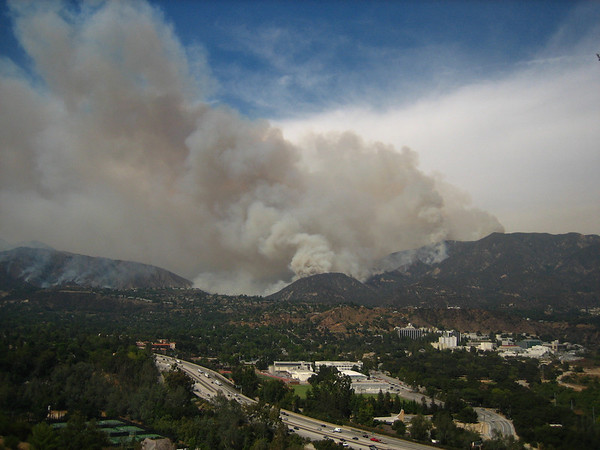
Here are some pictures, mostly from the San Rafael Hills near Flintridge Sacred Heart School around 4 PM. (There are a couple from in front of my house this morning.)

In this picture, the 210 Freeway, La Canada HS, and JPL are in the foreground.

Image
User avatar
AlanK
Posts: 1069
Joined: Thu Sep 27, 2007 9:28 pm

Post by AlanK »

The map of the burn area on the Star News Web site is greatly exaggerated. I went up Ocean View a ways and the fire is nowhere near that far west on the south slopes. This map is more accurate.
User avatar
mattmaxon
Posts: 1137
Joined: Mon Mar 24, 2008 12:48 pm

Post by mattmaxon »

This is some of the latest Modis data.....

Not good, any way you cut it

We'll have to wait for the smoke to clear to count our losses, some gains maybe as PO and pot farms will be trashed for a few years... Little solace

Image
User avatar
mattmaxon
Posts: 1137
Joined: Mon Mar 24, 2008 12:48 pm

Post by mattmaxon »

User avatar
cougarmagic
Posts: 1409
Joined: Wed May 07, 2008 5:21 pm

Post by cougarmagic »

The Arroyo, Brown Mtn, Switzer, Bear Canyon, possibly Millard...my heart is broken.
User avatar
Hikin_Jim
Posts: 4686
Joined: Thu Sep 27, 2007 9:04 pm

Post by Hikin_Jim »

cougarmagic wrote:The Arroyo, Brown Mtn, Switzer, Bear Canyon, possibly Millard...my heart is broken.
Eww. Let's hope the canyon bottom trees survive. Millard too, hunh? It's gotten that far east? Dang. :(
User avatar
Sewellymon
Posts: 104
Joined: Tue Feb 12, 2008 8:55 pm

Post by Sewellymon »

as of 10PM, not into Millard yet. Much of the Brown Mt Fire Road towards the Ken Burton trail, yes. Who knows what tomorrow brings, tho...
User avatar
Taco
Snownado survivor
Posts: 6036
Joined: Thu Sep 27, 2007 4:35 pm

Post by Taco »

Cool sequence.
User avatar
mattmaxon
Posts: 1137
Joined: Mon Mar 24, 2008 12:48 pm

Post by mattmaxon »

I checked with friends who have a house in Big Tujunga in La Paloma Flat
Jane wrote:"The fire hasn't reached the pines in GF yet, but it is also in Silver and S on the Side (maybe down to 2600ft).

The sheriff came by to warn about potential evacuations, but believes it won't happen unless we get unforeseen wind."
User avatar
mattmaxon
Posts: 1137
Joined: Mon Mar 24, 2008 12:48 pm

Post by mattmaxon »

This GE image shows the areas of Active burning detected on the pass overs at 5:50 GMT and 10:14 GMT (10pm 8/28 & 3am 8/29 local)

Seems strange the fire has retreated to it's "core" (mostly) with an extension toward Colby Cyn and upper Arroyo Seco toward Red Box

I'm not sure where others are seeing information on Millard Cyn being affected but I see no evidence it has gotten in there

But OTOH I have first hand reports the fire is in Silver Cyn too so who knows...confusion reigns! :evil:

Is it threatened..you bet... Will it get there who knows... this fire is crazy.... extreme behavior for sure, I hate to think what it'd be like with some Santa Ana's

Image

Image
User avatar
mattmaxon
Posts: 1137
Joined: Mon Mar 24, 2008 12:48 pm

Post by mattmaxon »

I noticed a perimeter map on the Inciweb info page

I have it out for carbon dating as they have no date or time on it, but it looks like the fire I saw on Thursday Morning 8/26

I extracted this relevant info and viola!

Obviously it has gotten much much bigger with a 5000 acre value

Image
User avatar
cougarmagic
Posts: 1409
Joined: Wed May 07, 2008 5:21 pm

Post by cougarmagic »

mattmaxon wrote:
I'm not sure where others are seeing information on Millard Cyn being affected but I see no evidence it has gotten in there
No direct evidence, just with how much it spread yesterday (1 day!) and how close it is, and no effort to contain the "back end" of the fire (just save the expensive houses....). Pessimistically inevitable....
User avatar
Mike P
Posts: 1005
Joined: Tue Oct 02, 2007 10:48 pm

Post by Mike P »

J- Was your camera in the path of this fire????
User avatar
cougarmagic
Posts: 1409
Joined: Wed May 07, 2008 5:21 pm

Post by cougarmagic »

Mike P wrote:J- Was your camera in the path of this fire????
Two cameras...

Image


Can you offer any encouragement on how larger animals deal with fire? I'm much more worried about that than my gear. I've read the lions can easily move out of the area, but then they have to deal with being in another's territory, plus loss of food & water. And the smoke is bad enough here - I hope they find some sheltered areas.
User avatar
HikeUp
Posts: 3902
Joined: Thu Sep 27, 2007 9:21 pm

Post by HikeUp »

Unreal how big this thing has gotten.

I've added more pics from today to flickr.

Friday at 12 noon...
Image
Saturday at 11:14a...
Image

Saturday at 11:14am
Image
Saturday at 12:41pm
Image
User avatar
mattmaxon
Posts: 1137
Joined: Mon Mar 24, 2008 12:48 pm

Post by mattmaxon »

My friends who live at la paloma flat where evacuated with flames within ¼ mile

I drove from Big-T Rd to La Cresenta (Ocean View Blvd)

Fire down into Hall-Beckley Canyon to at least 2900ft level

Probably lower from what I could see, but to there for sure

The south Side of Mt Lukens has fire in the Head of Haines Canyon

The North face of Mt Lukens from Grizzly Flat to probably Delta Cyn is in flames

The fire has jumped Big-T rd @ Stony Vale and is making a run for Condor Peak

Mandatory evacuations for Colby Ranch area too....
Post Reply