TR: Rabbit Peak from S-22/Villager Peak, 24-May-2008

TRs for desert ranges.
User avatar
Tim
Posts: 560
Joined: Tue Apr 08, 2008 8:55 pm

Post by Tim »

I've been waiting for the right day to do this day hike and Saturday was it. The sky was overcast to partly cloudy and the temperature was a cool 55°F with a light breeze out of the west. I could not have asked for a better day to hike a desert peak. Any lingering storm activity stayed well to the north.

To make a long story short, this hike was awesome! It was physically exhausting but the views, which went on and on, made up for it. The entire hike is along a ridge, so you get great views of Clark Valley, the Borrego Badlands and the Salton Sea nearly all the time. It feels like you're a lot higher up than you really are because the views extend so far out without any obstructions. The geology of this area is also fascinating. The surrounding mountains rise very abruptly from the perfectly flat desert floor. The landscape is filled with contrasting colors and textures and there is an impressively huge escarpment displaying various rock layers which I wish I understood better.

Another bonus is the relative isolation. Other than the Coachella Valley, I couldn't see any signs of large scale human activity for miles. I didn't even hear any dirt bikes or ATVs. Not another soul was on the mountain and according to Rabbit Peak's register, I was the first one to visit that peak in over a month. This is probably because it's been too hot but this was a nice change from our overused local mountains. Everything was so pristine--no graffiti, no trash, not even much of a trail.

The only exception was someone had glued reflector dots on some of the ocotillo plants. I would have taken then off but I was in a hurry to get down. I'm not a very fast hiker and I spent a lot of time taking pictures and admiring everything so I was very late getting back to my car. I had given my family a 10:00pm deadline to call SAR if I didn't check-in. I stumbled back to my car at 9:20pm but I still needed to drive several miles out to get cell coverage. I did manage to check-in before 10:00 but next time I've got to set a later check-in time or get off these mountains sooner.

Coyote Mountains in the distance:
Image

Lute Ridge:
Image

Field of angry Teddy Bear Cholla (these guys release little cholla balls from their stems that roam around looking for victims):
Image

This is either a swimming seal or a smiling dodo bird:
Image

Interesting rocks. I wish I had studied geology in school.
Image

Mini Stonehenge:
Image

OK, which cairn do I follow? View of Rabbit Peak from Villager.
Image

Burn area at the first saddle below Villager on the way to Rabbit:
Image

The 1992 notebook held 8 years worth of entries!
Image

More cool rock formations:
Image

The impressive escarpment:
Image

Rock layers:
Image

Found and removed two mylar balloons:
Image
User avatar
Terry Morse
Posts: 126
Joined: Mon Mar 03, 2008 8:55 pm

Post by Terry Morse »

Great pictures. I really like the colors that came out with the semi-cloudy light.
I've never been on those peaks, and didn't imagine that it looked like that up there.
User avatar
Taco
Snownado survivor
Posts: 6037
Joined: Thu Sep 27, 2007 4:35 pm

Post by Taco »

Beautiful shots! Anza Borrego FTW!
FIGHT ON

Post by FIGHT ON »

Nice pics Tim but HEY I WANTED TO DO THAT HIKE! HOW COME YOU DIDN'T INVITE ME? LOL.
Tim. Have you done Skyline before? If so how does that compare?
User avatar
Tim
Posts: 560
Joined: Tue Apr 08, 2008 8:55 pm

Post by Tim »

I have done the full C2C once. No question this is harder than Skyline (C2T). They have similar stats: 8,000' gain over 11 miles (one-way) but here you have to go back down without the aid of a tram. That in itself makes it harder, but it also means you have to carry more water.

IMO, this route is more interesting than Skyline. I know Skyline isn't a "trail" but you're more or less walking on a trail the entire time. Here you do boulder hopping, some mild scrambling (but no Class 3) and even a little cross-country. I like the diverse plant life and geology and that it's not popular nor hyped up. Even the name is modest and unassuming: Rabbit Peak. Besides, like Taco said, Anza-Borrego FTW!

My favorite part was going to Villager. I'm not sure if it's worth continuing on to Rabbit if I did it again. Those 7 bumps to Rabbit are really tough on morale.
FIGHT ON

Post by FIGHT ON »

Tim. I always end up carrying a ton too much water anyways. It sounds like on this hike you could stash some at Villager for when you return from Rabbit. Did you do that hike alone? I've been trying to get anybody to do that hike with me, even AllanK. lol. But no luck. Guess I'll just have to do it solo. Thanks AlanK. (AllanK ties fishing line to his son and has him pull him along the trail. It's true! I have photos.)
User avatar
Tim
Posts: 560
Joined: Tue Apr 08, 2008 8:55 pm

Post by Tim »

Yep, I did this solo. Sorry I didn't let you know I was going. Sounds like you really want to do it. You could cache water at Villager but you've got to make sure you have enough for the round trip to Rabbit and back. That's a tough stretch. Just don't try this in 90°+ temps. It doesn't go as high as Skyline so it's not going to get much cooler and the heat radiating off all rocks will bake you alive. There is no shade at all until about 5,000 ft.
FIGHT ON

Post by FIGHT ON »

Tim.
So from Villager to Rabbit, it is not just walking like on Skyline? Mostly jumping over and off of rocks and boulders, or a little or all the way? No red carpet trail?
User avatar
Tim
Posts: 560
Joined: Tue Apr 08, 2008 8:55 pm

Post by Tim »

Between Villager and Rabbit there is a "best route" marked by single rock cairns but you can actually walk wherever you want. The cacti are spread out so they're not really a problem. If I walked 20 or 30 feet and didn't see a cairn then I knew I was off the best route. I'd then traverse left or right until I spotted a cairn again. You can't really get lost because when in doubt just go back to the top of the ridge. But I did have a paper map and the route loaded on my GPS (SOP for solo hikes).

There is some boulder/rock hopping (maybe 30% of the time?). The boulders to Rabbit are different and not as nice as the ones to Villager. Those ones are smaller, flatter, closer together and more grippy.
User avatar
Rick M
Posts: 61
Joined: Mon Mar 17, 2008 4:11 pm

Post by Rick M »

Tim said
To make a long story short, this hike was awesome!...IMO, this route is more interesting than Skyline. I know Skyline isn't a "trail" but you're more or less walking on a trail the entire time. Here you do boulder hopping, some mild scrambling (but no Class 3) and even a little cross-country. I like the diverse plant life and geology and that it's not popular nor hyped up
Tim, you just hyped it up :lol:

Good info and I really like what you did with these
Found and removed two mylar balloons:
When we are out searching, anything unnatural out there needs to be checked out and I hate getting diverted to check out old wrappers or other junk not left by the missing person. The back country is usually pretty clean of stuff dropped but on some of the longer SAR missions, my pockets will be packed with old stuff...my attempt at cleaning up the mountains AND making future searches "easier" :wink: Thanks again
User avatar
He219
Posts: 386
Joined: Thu Sep 27, 2007 11:18 pm

Post by He219 »

Beautiful images.
Thanks for your TR!
:D
FIGHT ON

Post by FIGHT ON »

Tim wrote:I've been waiting for the right day to do this day hike and Saturday was it. The sky was overcast to partly cloudy and the temperature was a cool 55°F with a light breeze out of the west. I could not have asked for a better day to hike a desert peak. Any lingering storm activity stayed well to the north.
Tim. Did you use a tripod when taking these pics?
User avatar
Tim
Posts: 560
Joined: Tue Apr 08, 2008 8:55 pm

Post by Tim »

Jeebus! :shock: No need to re-quote the entire post with all the pictures. This makes the page load slow.

I didn't use a tripod.
FIGHT ON

Post by FIGHT ON »

Tim wrote:Jeebus! :shock: No need to re-quote the entire post with all the pictures. This makes the page load slow.
Ok thanks for the advice!
User avatar
Tim
Posts: 560
Joined: Tue Apr 08, 2008 8:55 pm

Post by Tim »

:arrow:
FIGHT ON

Post by FIGHT ON »

If you can't say anything nice don't say anything at all!
User avatar
Taco
Snownado survivor
Posts: 6037
Joined: Thu Sep 27, 2007 4:35 pm

Post by Taco »

FIGHT ON,

Do not quote a post with a shitload of pictures in it. it makes it very slow for lots of us to load. I have editted the post so it doesn't display the images.

Tone it down a bit, please.
User avatar
Tim
Posts: 560
Joined: Tue Apr 08, 2008 8:55 pm

Post by Tim »

:arrow:
User avatar
Taco
Snownado survivor
Posts: 6037
Joined: Thu Sep 27, 2007 4:35 pm

Post by Taco »

Fight on is just being himself.

That said, Fight on, kinda tone it down a bit. Your joking doesn't typically seem to entertain anyone but yourself.
FIGHT ON

Post by FIGHT ON »

well I deleted it!
FIGHT ON

Post by FIGHT ON »

If you can't say anything nice don't say anything at all!
User avatar
simonov
Posts: 1087
Joined: Tue Nov 27, 2007 5:44 pm
Location: Reno, NV
Contact:

Post by simonov »

FIGHT ON wrote:
TacoDelRio wrote:Fight on is just being himself.

That said, Fight on, kinda tone it down a bit. Your joking doesn't typically seem to entertain anyone but yourself.
I stand corrected. IMVVVVVVVVVVVHO, Maybe I would be good to make a rule not to post a mile of pics. Use a link instead. It is kinda not fun to load threads when someone new posts. But hey. Who am I? :lol:
It's simpler than that. Post all the pics you want for an original post, and simply edit any replies.

Whoa.
Nunc est bibendum
FIGHT ON

Post by FIGHT ON »

simonov wrote:
FIGHT ON wrote:
TacoDelRio wrote:Fight on is just being himself.

That said, Fight on, kinda tone it down a bit. Your joking doesn't typically seem to entertain anyone but yourself.
I stand corrected. IMVVVVVVVVVVVHO, Maybe I would be good to make a rule not to post a mile of pics. Use a link instead. It is kinda not fun to load threads when someone new posts. But hey. Who am I? :lol:
It's simpler than that. Post all the pics you want for an original post, and simply edit any replies.

Whoa.

Whoat?
I was talking about if you have a billion pictures on an original post instead of using a link to the the same pictures, it's a hassle having to wait for them to load to view new posts. A few pictures is ok but anything after that a link makes sense. proof that even an idiot can make a good point!
User avatar
Tim
Posts: 560
Joined: Tue Apr 08, 2008 8:55 pm

Post by Tim »

:arrow: Too much drama.
User avatar
HikeUp
Posts: 3932
Joined: Thu Sep 27, 2007 9:21 pm

Post by HikeUp »

Great TR Tim. I personally think your contributions to this board are interesting and indeed valuable. Keep them coming.
User avatar
Tim
Posts: 560
Joined: Tue Apr 08, 2008 8:55 pm

Post by Tim »

Thanks for the support, HikeUp.
FIGHT ON

Post by FIGHT ON »

Tim wrote:I've been waiting for the right day to do this day hike and Saturday was it. The sky was overcast to partly cloudy and the temperature was a cool 55°F with a light breeze out of the west. I could not have asked for a better day to hike a desert peak. Any lingering storm activity stayed well to the north.

To make a long story short, this hike was awesome! It was physically exhausting but the views, which went on and on, made up for it. The entire hike is along a ridge, so you get great views of Clark Valley, the Borrego Badlands and the Salton Sea nearly all the time. It feels like you're a lot higher up than you really are because the views extend so far out without any obstructions. The geology of this area is also fascinating. The surrounding mountains rise very abruptly from the perfectly flat desert floor. The landscape is filled with contrasting colors and textures and there is an impressively huge escarpment displaying various rock layers which I wish I understood better.

Another bonus is the relative isolation. Other than the Coachella Valley, I couldn't see any signs of large scale human activity for miles. I didn't even hear any dirt bikes or ATVs. Not another soul was on the mountain and according to Rabbit Peak's register, I was the first one to visit that peak in over a month. This is probably because it's been too hot but this was a nice change from our overused local mountains. Everything was so pristine--no graffiti, no trash, not even much of a trail.

The only exception was someone had glued reflector dots on some of the ocotillo plants. I would have taken then off but I was in a hurry to get down. I'm not a very fast hiker and I spent a lot of time taking pictures and admiring everything so I was very late getting back to my car. I had given my family a 10:00pm deadline to call SAR if I didn't check-in. I stumbled back to my car at 9:20pm but I still needed to drive several miles out to get cell coverage. I did manage to check-in before 10:00 but next time I've got to set a later check-in time or get off these mountains sooner.
Tim. Have you hiked Skyline?
Near the top are some spots where your camera would be in heaven!
User avatar
Tim
Posts: 560
Joined: Tue Apr 08, 2008 8:55 pm

Post by Tim »

FIGHT ON wrote:Tim. Have you hiked Skyline?
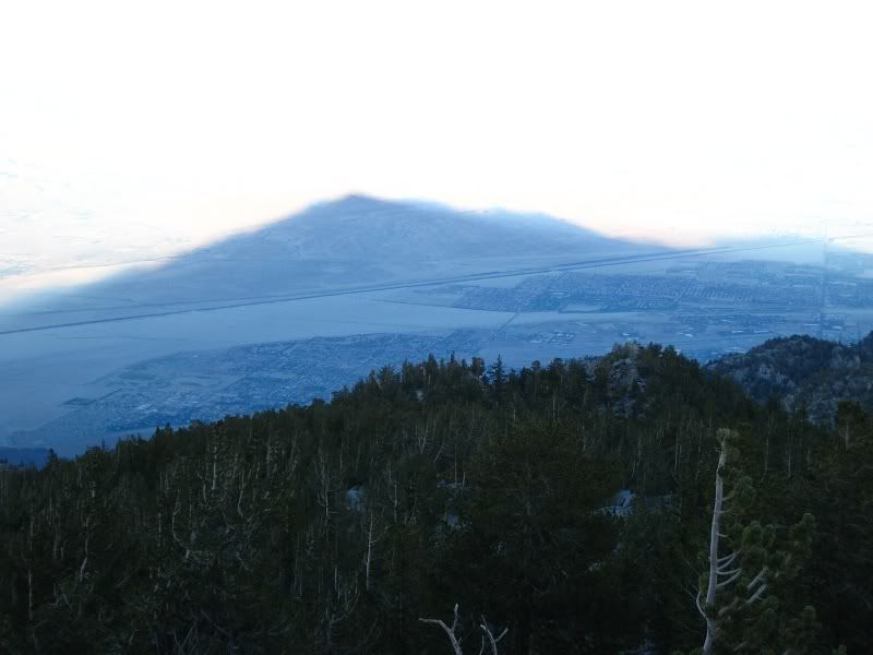
Yes, I have. I reached the summit just as the sun was coming down. The mountain cast a huge shadow over Palm Springs. It had the classic triangular shape of a mountain. It was a poignant moment since I could see where I started (the desert) and where I am now (literally on top of the mountain) all in the same view.

Image
FIGHT ON

Post by FIGHT ON »

Tim wrote:
FIGHT ON wrote:Tim. Have you hiked Skyline?
Yes, I have. I reached the summit just as the sun was coming down. The mountain cast a huge shadow over Palm Springs. It had the classic triangular shape of a mountain. It was a poignant moment since I could see where I started (the desert) and where I am now (literally on top of the mountain) all in the same view.
Shoulda held your arm up, (and maybe gave the ol friendowl salute!) With how clear your camera takes images I bet it would have come out! :D
User avatar
calicokid
Posts: 90
Joined: Wed Feb 27, 2008 1:07 pm

Post by calicokid »

Tim,

That was a great shot with the shadow of the mountain. That picture tells thousand words about your planning and efforts to take that photo.

Thanks for all beautiful pics and TRs.

Hanh
Post Reply