Gotchy, Phillip, Muir, and West Fuji

TRs for the San Gabriel Mountains.
User avatar
Matthew
Supercaff
Posts: 189
Joined: Mon Nov 30, 2015 8:25 am
Location: Pasadena

Post by Matthew »

The goal of the day was very simple: To get to this strange building that is next to Inspiration Point to see if it was mine related. The following image is from 1960 and has the building circled.
hut.jpg
On the side, I have been trying to locate all the mines in the Monitor Consolidated Claims with Dima, so this spot was close to a shaft we mapped. I started my hike at the bottom of the Lone Tree trail and climbed up to West Fuji. Now some sources told me that someone put a sign up on West Fuji calling it Phillips Point! This is totally inaccurate since the local common name has been West Fuji since at least the 1970s according to John W. Robinson in his book, "The San Gabriels." This person even crossed out the correctly named "West Fuji" and wrote "Phillips Point" in the peak registry that was placed by Coby King. I reached out to Coby on Facebook and he said he did not place the sign. More on this later.
Sign
Sign
Registry
Registry
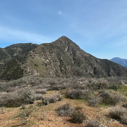
I continued my hike up to Muir Peak. The stretch between West Fuji and Muir is steep AF with grades hitting the 35% range and it never gets easier the more and more you do it. After reaching the summit, I took a much needed break and took in the wonderful scenery of Mt. Wilson and Upper Eaton Canyon.
Views
Views
From the peak to Inspiration Point is about 10 minutes of flat road on the One Man One Mule trail. From Inspiration, I took Castle Canyon trail down then started a short scramble up the hill before immediately finding broken old plates and glasses!
Plate
Plate
Right there, under an oak and next to a manzanita, I found the old wall of the cabin! Most of what was left were pieces of metal, glass, plates, stone, and concrete. There was also a circular wide pipe in the ground which was probably where the outhouse was.
IMG_5654.JPEG
IMG_5658.JPEG
IMG_5659.JPEG
IMG_5665.JPEG
The next few photos were provided by Jeremiah showing what the cabin looked like in the 50s. The cabin was owned by a WWII vet named L.T. Gotchy and not the site for a mine I was trying to find.
IMG_4313.JPEG
IMG_4316.JPEG
IMG_4317.JPEG

Okay, back to West Fuji! I picked up the sign and registry and got back to my car pretty late in the afternoon after many breaks in the shade (it was 85F outside.) The question on me and my friends' minds was who would rename an already named peak something as random as Phillips Point? There was no mention of it on OSM or on any major hiking forums nor was it on any facebook posts. I began digging through the registry and finding people's social media accounts based on full names written. Here is the timeline that we have to work with.

3/3/2024 Johnny's Syndicate (youtube channel) logs an entry. I find a video of him climbing the peak. No sign in sight. https://www.youtube.com/watch?v=oqNKRzdGGLw
3/24/2024 on AllTrails taken by Ryan Kellis with Phillips Point sign.
4/6/2024 Joseph Koetters posts a TR on AllTrails calling the peak Phillips Point. This is the only online mention of the peak.
5/11/2024 Noti Akino takes photo of sign.
8/17/2024 Darren Ng takes photo of sign.
9/20/2024 Dima removes the sign and places it behind bush
9/22/2024 I, Matthew, takes sign and registry and places sign in my living room.

There are 2 entries in the registry by a person who signed it "JTK" in all caps. This is notable since they spelled PHILLIPS POINT in all caps on the cover of the registry. So whoever JTK is, "Hey! You misspelled the sign. It should have been spelled W-e-s-t_F-u-j-i with an elevation of 3681 Ft."
User avatar
dima
Posts: 1433
Joined: Wed Feb 12, 2014 1:35 am

Post by dima »

So it's just some dude's house? Was he squatting? I don't think there's an inholding right there, right? And the mine, if it exists, is somewhere else?
User avatar
Nate U
Posts: 294
Joined: Wed Apr 05, 2023 7:38 pm

Post by Nate U »

Great trip report. LT Gotchy looks like a legend - I want to hang out in that cabin with him. Did he himself build his cabin? Did he actually own or lease the land?

I give Phillip credit for making and erecting his giant sign, but I think his vanity got the best of him. Now until he claims it, you have a great piece of decor for your living room.

I am continually amazed by how much great history is just below the surface all around Eaton Canyon. Remarkable place.
User avatar
Nate U
Posts: 294
Joined: Wed Apr 05, 2023 7:38 pm

Post by Nate U »

Since we are scrutinizing peak names in that area, what's the deal with having both a Muir Peak AND "Mount Muir"?
Screen Shot 2024-09-23 at 8.04.30 PM.png
And then OSM has "Muir Peak" where Cal Topo has "Mount Muir" with no name where Forest Service map and Cal Topo has "Muir Peak"
Screen Shot 2024-09-23 at 8.07.53 PM.png
Screen Shot 2024-09-23 at 8.10.59 PM.png
This is confusing. Can we blame Phillip for this too?
User avatar
Matthew
Supercaff
Posts: 189
Joined: Mon Nov 30, 2015 8:25 am
Location: Pasadena

Post by Matthew »

dima wrote: Mon Sep 23, 2024 7:55 pm So it's just some dude's house? Was he squatting? I don't think there's an inholding right there, right? And the mine, if it exists, is somewhere else?
The mine is definitely somewhere else. I think we can further narrow down our georeferencing by finding the exact location of the Pine, Summit, and Carrie mines.
User avatar
dima
Posts: 1433
Joined: Wed Feb 12, 2014 1:35 am

Post by dima »

Nate U wrote: Mon Sep 23, 2024 8:05 pm Since we are scrutinizing peak names in that area, what's the deal with having both a Muir Peak AND "Mount Muir"?
What I've always been told is that the usgs map putting "Muir Peak" next to Inspiration Point was a mistake. But the usgs is kinda the definition of truth, so I don't know.
Nate U wrote: Mon Sep 23, 2024 8:05 pm And then OSM has "Muir Peak" where Cal Topo has "Mount Muir" with no name where Forest Service map and Cal Topo has "Muir Peak"
OSM has "Muir peak" on the bump in the East and nothing on the bump to the West. Caltopo is giving you the "MapBuilder Topo" layer, which apparently has "Mount Muir". I'm not entirely sure what that layer is.
Nate U wrote: Mon Sep 23, 2024 8:05 pm This is confusing. Can we blame Phillip for this too?
Phillips. We can blame Phillips. I'm going to give the sign man the benefit of the doubt, and assume that they can spell.
User avatar
Matthew
Supercaff
Posts: 189
Joined: Mon Nov 30, 2015 8:25 am
Location: Pasadena

Post by Matthew »

Nate U wrote: Mon Sep 23, 2024 8:05 pm Since we are scrutinizing peak names in that area, what's the deal with having both a Muir Peak AND "Mount Muir"?

Screen Shot 2024-09-23 at 8.04.30 PM.png

And then OSM has "Muir Peak" where Cal Topo has "Mount Muir" with no name where Forest Service map and Cal Topo has "Muir Peak"

Screen Shot 2024-09-23 at 8.07.53 PM.png
Screen Shot 2024-09-23 at 8.10.59 PM.png

This is confusing. Can we blame Phillip for this too?
I don't wanna talk about it :cry:
User avatar
Matthew
Supercaff
Posts: 189
Joined: Mon Nov 30, 2015 8:25 am
Location: Pasadena

Post by Matthew »

Aerial image from 5/27/24 shows sign clearly!
Screenshot 2024-09-23 204851.png
User avatar
Nate U
Posts: 294
Joined: Wed Apr 05, 2023 7:38 pm

Post by Nate U »

dima wrote: Mon Sep 23, 2024 8:20 pm OSM has "Muir peak" on the bump in the East and nothing on the bump to the West. Caltopo is giving you the "MapBuilder Topo" layer, which apparently has "Mount Muir". I'm not entirely sure what that layer is.
I've always assumed Caltopo's "MapBuilder Topo" layer was drawing from OSM data, with periodic updates from the OSM source, but not continuously updated like the actual OSM is. I'm fairly confident in this because "MapBuilder Topo" has things like Centennial Peak.

Whatever the case, because everyone wants to know, my feeling would be that whole series of bumps south of Mount Lowe is all a Mount Muir, full of peaks, history, and good times :)
Screen Shot 2024-09-24 at 9.27.43 AM.png
User avatar
Sean
Cucamonga
Posts: 3918
Joined: Wed Jul 27, 2011 12:32 pm

Post by Sean »

The misplaced "Muir Peak" label is an annoying error from the USGS map. I think the error occurred on the '95 version, but don't quote me on that. It's been awhile since I did the research.

Also, the historical photos are of Gotchy's cabin south of Mt. Muir, near Panorama Point, not Inspiration. Paul posted them several years ago with detailed descriptions.
Screenshot_20240924-094926~2.png
Screenshot_20240924-094949~2.png
According to the Mount Lowe Preservation Society, the cabin near Inspiration Point originally belonged to Ed Tobin, creator of the OM&M railroad. Gotchy was the second owner of the Tobin cabin.
User avatar
dima
Posts: 1433
Joined: Wed Feb 12, 2014 1:35 am

Post by dima »

Nate U wrote: Tue Sep 24, 2024 9:30 am I've always assumed Caltopo's "MapBuilder Topo" layer was drawing from OSM data, with periodic updates from the OSM source, but not continuously updated like the actual OSM is. I'm fairly confident in this because "MapBuilder Topo" has things like Centennial Peak.
Yes, but as we're seeing here, MapBuilder Topo has extra stuff on top of OSM: there's no "Mount Muir" in OSM, and there never has been (I just looked at the history). I haven't dug into it to know any more than that.
User avatar
Nate U
Posts: 294
Joined: Wed Apr 05, 2023 7:38 pm

Post by Nate U »

dima wrote: Tue Sep 24, 2024 11:21 am Yes, but as we're seeing here, MapBuilder Topo has extra stuff on top of OSM: there's no "Mount Muir" in OSM, and there never has been (I just looked at the history). I haven't dug into it to know any more than that.
Hmmm, indeed! Mysterious...
User avatar
stonehillnews
Posts: 77
Joined: Thu Dec 15, 2016 1:31 pm

Post by stonehillnews »

I took this photo at the same time as I took the ones @jeko1034 posted at the Historical Society. Here's an OCR copy/paste off the photo.
L.T. Gotchy
• Although he never lived in Altadena, L.T. Gotchy personified the iconoclastic nature of our community.
• After serving in the army in WWII, he worked for the Forest Service Fire Department at a camp based at the ruins of Alpine Tavern and lived in one of three Forest Service cabins built near Mount Lowe.
• He and his fellow crew members, known as "dingbats," fought forest fires wearing badges Gotchy created for the non-existent Mount Lowe Fire department.
• For many years he traveled through California, installing signs for AAA.
• He was an excellent photographer who produced many thousands of photographs including the ruins of Mt. Lowe and was an avid collector of Mt. Lowe memorabilia.
• He was a voluminous writer and correspondent, expressing his thoughts and opinions in his own colorful language (see his autobiography and the quotations on the wall.)
IMG_4318.jpeg
User avatar
stonehillnews
Posts: 77
Joined: Thu Dec 15, 2016 1:31 pm

Post by stonehillnews »

Sean wrote: Tue Sep 24, 2024 10:05 amnear Panorama Point
I've never heard a definitive answer I was satisfied with. Do you guys think Panorama Point is right their by the water tank at the end of OM&M? Another plausible option is at the dogleg on OM&M where the ridge heads down into Eaton above the falls.
User avatar
stonehillnews
Posts: 77
Joined: Thu Dec 15, 2016 1:31 pm

Post by stonehillnews »

Speaking of Gotchy, I got a copy of this letter he wrote about Ed Nohr who built the AMRT Cabin 16 in the Millard tract.

As you can see, Gotchy was prone to a great deal of hyperbole. Also, he casually mentions Ed "terminating" a guy in a fight...anyways, all I know is what you see in the letter. I can neither confirm nor deny the veracity of most of it.

Cabin 16, letter page 1, Ed Nohr, LT Gotchy, 1966.jpeg
Cabin 16, letter page 2, LT Gotchy, 1966.jpeg


These are closeups of the photos that were attached

Cabin 16 views 1a, LT Gotchy, 1966.jpeg
Cabin 16 views 1b, LT Gotchy, 1966.jpeg
Cabin 16 views 2a, LT Gotchy, 1966.jpeg
Cabin 16 views 2b, LT Gotchy, 1966.jpeg
Cabin 16, letter page 1 L, Ed Nohr, LT Gotchy, 1966.jpeg
Cabin 16, letter page 1 R, Ed Nohr, LT Gotchy, 1966.jpeg
User avatar
Sean
Cucamonga
Posts: 3918
Joined: Wed Jul 27, 2011 12:32 pm

Post by Sean »

stonehillnews wrote: Tue Sep 24, 2024 3:02 pm
Sean wrote: Tue Sep 24, 2024 10:05 amnear Panorama Point
I've never heard a definitive answer I was satisfied with. Do you guys think Panorama Point is right their by the water tank at the end of OM&M? Another plausible option is at the dogleg on OM&M where the ridge heads down into Eaton above the falls.
OM&M ended before the water tank, which was installed later, probably after/during the dismantling of OM&M. I believe there are photos of old signs directing hikers to Panorama Point and Morning Glory Point, both of which were somewhere around the end of the OM&M. I cannot find Panorama or Morning Glory on any USGS or FS map. Tom Harrison, however, puts Panorama where the water tank is.

Old photo of Panorama Point with Gotchy cabin and outhouse in view.
FB_IMG_1727200801822.jpg
User avatar
dima
Posts: 1433
Joined: Wed Feb 12, 2014 1:35 am

Post by dima »

So if Gotchy's cabin was by Muir Peak, what did jeko1034 find?
User avatar
Matthew
Supercaff
Posts: 189
Joined: Mon Nov 30, 2015 8:25 am
Location: Pasadena

Post by Matthew »

Got it! So Gotchy's cabin was actually right on Mount Muir! So the cabin I visited wasn't that cabin and was probably another in the tract right?
User avatar
dima
Posts: 1433
Joined: Wed Feb 12, 2014 1:35 am

Post by dima »

Sean wrote: Tue Sep 24, 2024 10:05 am The misplaced "Muir Peak" label is an annoying error from the USGS map. I think the error occurred on the '95 version, but don't quote me on that. It's been awhile since I did the research.
So the "MapBuilder Topo" layer comes "from a variety of sources, including USGS data sets, OpenStreetMap and high resolution LIDAR (where available)". OSM doesn't do Mount Muir. And the USGS doesn't either, and they now put Muir Peak on the East part of the ridge: https://edits.nationalmap.gov/apps/gaz- ... arch/names

So the older USGS map was indeed mistaken, and we still don't know where "Mount Muir" comes from.
User avatar
Sean
Cucamonga
Posts: 3918
Joined: Wed Jul 27, 2011 12:32 pm

Post by Sean »

dima wrote: Tue Sep 24, 2024 9:17 pm So if Gotchy's cabin was by Muir Peak, what did jeko1034 find?
I think he found Ed Tobin's cabin, but I've never seen photos of Tobin's cabin.
User avatar
Sean
Cucamonga
Posts: 3918
Joined: Wed Jul 27, 2011 12:32 pm

Post by Sean »

dima wrote: Tue Sep 24, 2024 9:29 pmSo the older USGS map was indeed mistaken, and we still don't know where "Mount Muir" comes from.
Muir's Peak comes from Hiram Reid in History of Pasadena, but some cartographers have failed miserably at locating it.
Screenshot_20240924-215944-200.png
User avatar
Sean
Cucamonga
Posts: 3918
Joined: Wed Jul 27, 2011 12:32 pm

Post by Sean »

Mapbuilder Topo appears to be accurate regarding Muir, and it is consistent with the 1966 USGS placement.
MapBuilder Topo
MapBuilder Topo
1966 Mt Wilson USGS
1966 Mt Wilson USGS
User avatar
Sean
Cucamonga
Posts: 3918
Joined: Wed Jul 27, 2011 12:32 pm

Post by Sean »

Matthew wrote: Tue Sep 24, 2024 9:18 pm Got it! So Gotchy's cabin was actually right on Mount Muir! So the cabin I visited wasn't that cabin and was probably another in the tract right?
Right. You visited #2, which I think was Ed Tobin's cabin. I dug up this photo from Paul but it's hard to see the cabin and it doesn't say who lived there.
Screenshot_20240924-230208-407.png
FB_IMG_1727244132930.jpg
Cabin #1 was the Cliffe House near Lowe Camp.
Screenshot_20240924-230126-054.png
Don't know who lived there. The ruins here are more substantial than at #2.
User avatar
stonehillnews
Posts: 77
Joined: Thu Dec 15, 2016 1:31 pm

Post by stonehillnews »

Sean wrote: Tue Sep 24, 2024 11:14 pm Right. You visited #2, which I think was Ed Tobin's cabin. I dug up this photo from Paul but it's hard to see the cabin and it doesn't say who lived there.

Cabin #1 was the Cliffe House near Lowe Camp.
Don't know who lived there. The ruins here are more substantial than at #2.
Anyone have lat/longs or an old map that shows the Mt Lowe tract cabins? Having a hard time visualizing location of cabin 1. Didn’t know about cabin 2 either. From the photo, looks like maybe Castle Cyn trail was access to it?
User avatar
Tom Kenney
Posts: 383
Joined: Sat Sep 29, 2007 7:51 pm

Post by Tom Kenney »

That's a very compact typewriter (Mr. Gotchy's).

You could troll the Phillips Point people by posting photographs of their sign placed at the end of a random breakwater, like Marina Del Rey. Whole thing smacks of the Mt Thoreau/Mt George Davis kerfluffle. I've sworn off Bob Burd because of that.

EDIT to add: Sean's post of the red delivery looks like the cabin sits where the water tank now is, on that gentle shoulder above the end of the road.
User avatar
Sean
Cucamonga
Posts: 3918
Joined: Wed Jul 27, 2011 12:32 pm

Post by Sean »

stonehillnews wrote: Wed Sep 25, 2024 7:43 amAnyone have lat/longs or an old map that shows the Mt Lowe tract cabins?
I labeled them 1-3.
Mt Lowe cabins.jpg
User avatar
dima
Posts: 1433
Joined: Wed Feb 12, 2014 1:35 am

Post by dima »

Oh yeah; how about that. They're actually on the map. Here's the full topo quad, for easier referencing
CA_Mt Lowe_293326_1939_24000_geo.pdf
(14.26 MiB) Downloaded 6 times
User avatar
Sean
Cucamonga
Posts: 3918
Joined: Wed Jul 27, 2011 12:32 pm

Post by Sean »

I dug up a few more items. This is the best quality image I have of the Cliffe House (Mt. Lowe Tract #1).
MT LOWE TRACT CABIN 1 WURMSER.jpg
The filename includes "Wurmser." Maybe that's who owned it, but I don't remember how I acquired this file. Probably from Paul.

Here is a photo titled "Herbert's Power House." Herbert was Ed Tobin's mule. I don't know where this structure was located exactly. Possibly at the end of the line, possibly near the beginning.
mountlowe-Herberts-Power-House.jpg
And this is an old Mt. Lowe brochure. It contains a description of Morning Glory Point, which might have been where the water tank is now.
DSCF6744a.JPG
User avatar
stonehillnews
Posts: 77
Joined: Thu Dec 15, 2016 1:31 pm

Post by stonehillnews »

Sean wrote: Wed Sep 25, 2024 1:43 pm I labeled them 1-3.
Mt Lowe cabins.jpg
Is cabin 1 site near or on the current day Spencer’s Lookout?
User avatar
Uncle Rico
Posts: 1413
Joined: Thu Mar 20, 2008 7:48 pm

Post by Uncle Rico »

Damn interesting thread guys. Thanks for posting all this info.

Ed Nohr sounds like a total stud and looks a bit like Hunter S. Thompson. Ha ha.
Post Reply