
Yes.FIGHT ON wrote:You got a map that has it named on it?
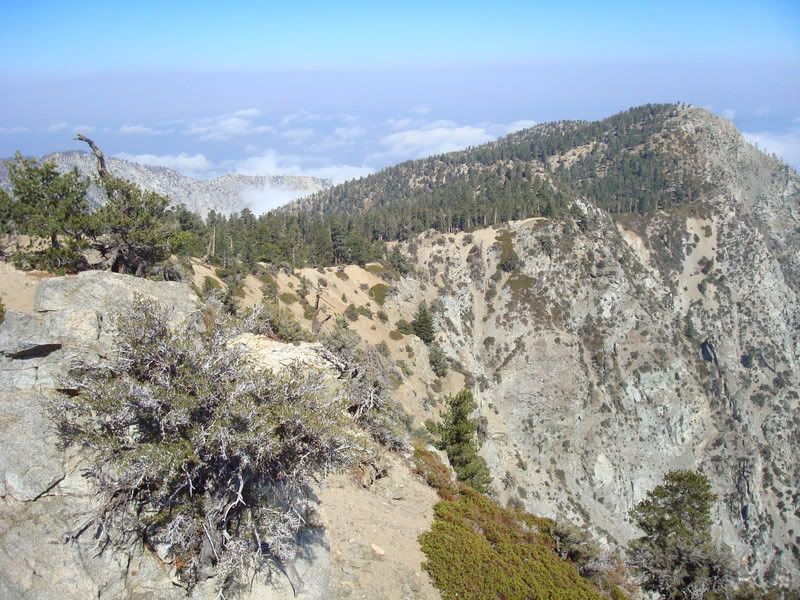
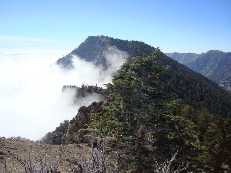
Attempted Baldy 9 Peaks Challenge, 02-Aug-2008
-
AlanK

- Posts: 1069
- Joined: Thu Sep 27, 2007 9:28 pm
-
simonov

- Posts: 1102
- Joined: Tue Nov 27, 2007 5:44 pm
- Location: Reno, NV
I've seen the trail to Etiwanda where it branches off from the short trail to Cucamonga summit, but is there a sign for Etiwanda when you go down that trail? I want to climb Etiwanda next time I am on Cucamonga but I am not sure how to get there and whether it is marked.
Nunc est bibendum
-
Hikin_Jim

- Posts: 4688
- Joined: Thu Sep 27, 2007 9:04 pm
I don't recall seeing a sign, but I haven't been up Etiwanda in quite a while. There's no official trail.
Basically, if you look at the topo map link below, you have to go east from the junction with the Cucamonga summit trail (approximately at point "A"). You need to drop down a ways first to a smaller saddle ("B") and then to a second larger saddle ("C"). After the larger saddle, follow the trail as it climbs NE. There is a bit of a use trail heading up the ridge, but I can't recall exactly where it takes off after the larger saddle ("C"). If you don't see a decent use trail, you can follow the main trail around to the north to approximately point "D". From this point, climb up to the top of SW summit ridge of Etiwanda to the smallish saddle just above point "D." Follow the ridge to the peak.
Alternatively, you could just walk the ridge all the way from the 2nd, larger saddle to Etiwanda. Taking the ridge all the way makes for easier nav, but it's a bit more work.
http://mapper.acme.com/?ll=34.22545,-11 ... tland%20CA
-
He219

- Posts: 386
- Joined: Thu Sep 27, 2007 11:18 pm
There is a trail, but not well traveled and difficult to find most of the time.simonov wrote: I want to climb Etiwanda next time I am on Cucamonga but I am not sure how to get there and whether it is marked.
Like Jim wrote, follow the ridge to Etiwanda.
Try not to get too close to the edge ..
Cucamonga & Etiwanda Peaks - Oct. 12th, 2007
-
HikeUp

- Posts: 4036
- Joined: Thu Sep 27, 2007 9:21 pm
Is it possible, when returning from Etiwanda, to contour around the north side of Cucamonga to avoid some elevation gain? My guess is it is probably not worth the effort.
-
Hikin_Jim
- Posts: 4688
- Joined: Thu Sep 27, 2007 9:04 pm
Probably not. The regular trail doesn't go to the summit itself, so at least you don't have to re-summit.
-
Tim

- Posts: 560
- Joined: Tue Apr 08, 2008 8:55 pm
I think I read in a TR somewhere that someone has tried this, but maybe it was during the winter. It's not worth the trouble, IMO.HikeUp wrote:Is it possible, when returning from Etiwanda, to contour around the north side of Cucamonga to avoid some elevation gain? My guess is it is probably not worth the effort.
There's no sign at the turnoff from the trail to Etiwanda. After the second saddle you can tell you're getting closer to the peak so just keep an eye out for a turnoff on the right (south) side of the trail. The main trail is in good shape and mainly gets indistinct in the broad, flat areas of the ridge near Cucamonga.
-
He219
- Posts: 386
- Joined: Thu Sep 27, 2007 11:18 pm
Direct is better. We tried going around north last year.HikeUp wrote:Is it possible, when returning from Etiwanda, to contour around the north side of Cucamonga to avoid some elevation gain? My guess is it is probably not worth the effort.
Huge detour, turned around after gaining even more elevation ..
-
HikeUp
- Posts: 4036
- Joined: Thu Sep 27, 2007 9:21 pm
Thanks Jim, Tim and Uhu for the 1st hand info. Priceless! 
-
Taco

- Snownado survivor
- Posts: 6136
- Joined: Thu Sep 27, 2007 4:35 pm
Yeah, going back up Cucamonga from Etiwanda seemed to go by real fast, for some reason.
-
Rob
- Posts: 158
- Joined: Thu Sep 27, 2007 9:26 pm
I've ascended BCT 3 times and each time been unable to get a good jumping-off GPS fix at the Visitor's Center. My Garmin says it acquired satellites, but later when I review the track, the fixes jump hundreds of yards in all directions.Tim wrote:my car was parked outside the Visitor Center. .... up Bear Canyon Rd. .... My GPS could not receive any signals .... it didn't start recording until he dropped me off.
-
FIGHT ON
Tim wrote: I started at the Visitor Center at 4:30am. I was the first one there, but within a few minutes an old guy in a truck pulled up to get his permit from the bulletin board. Was this the elusive Fight On?
NO! It was not. I just talked to Charles tonight and he had arrived at the visitor center shortly after you did Tim. Like at 4:35. He told me he saw you and was friendly. Now that should have been your first clue!
-
JMunaretto
- Posts: 370
- Joined: Thu Feb 07, 2008 11:03 am
Yeah Tim, you didn't look too happy when we saw you around Telegraph! Was it mostly about the heat, lack of sleep, water, food, or a combination?
I think I need to try some of these longer challenges. I actually can lug up less water initially up Bear Canyon if I stop at Baldy Notch and fill up at the water fountain. I can start with 4 then fill up 5 more and try to get 8 peaks. For me water is definitely a problem. I can carry enough food to last me as I don't eat very much during hikes anyways.
I think, even in the heat, your hike wouldn't be so terrible if you had more sleep and enough food & water.
-
FIGHT ON
Silver Moccasin TrailJMunaretto wrote:I think I need to try some of these longer challenges. I actually can lug up less water initially up Bear Canyon if I stop at Baldy Notch and fill up at the water fountain. I can start with 4 then fill up 5 more and try to get 8 peaks.
-
Tim
- Posts: 560
- Joined: Tue Apr 08, 2008 8:55 pm
It was mostly being nauseated. But that was probably caused by the heat and an empty stomach. I didn't eat very much and after all these years of hiking I still haven't figured out a good method of eating right. The lack of sleep didn't help and I had technical difficulties with my shoes which felt like they were ripping my toenails off on the downhills.JMunaretto wrote:Was it mostly about the heat, lack of sleep, water, food, or a combination?... I think, even in the heat, your hike wouldn't be so terrible if you had more sleep and enough food & water.
I don't deal with the heat well so even if I did everything else right, I still would have had a miserable time. I'll try this again in the fall.
-
Cy Kaicener
- Posts: 163
- Joined: Fri Sep 28, 2007 5:19 am
The goal has been raised. Rick Graham has completed a 13 peak challenge in 16 hours. Now thats a long day in a fast time.
http://www.mt-whitney.info/viewtopic.php?t=2431
http://www.mt-whitney.info/viewtopic.php?t=2431
-
FIGHT ON
I got money Kent goes sub 15.5 hrs. doing the back stroke! 8)Cy Kaicener wrote:The goal has been raised. Rick Graham has completed a 13 peak challenge in 16 hours. Now thats a long day in a fast time.
http://www.mt-whitney.info/viewtopic.php?t=2431
-
Tim
- Posts: 560
- Joined: Tue Apr 08, 2008 8:55 pm
Wow, that's really impressive. Good job Rick Graham!Cy Kaicener wrote:The goal has been raised. Rick Graham has completed a 13 peak challenge in 16 hours. Now thats a long day in a fast time.
http://www.mt-whitney.info/viewtopic.php?t=2431